 W
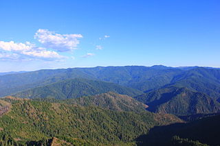
WThe Rogue River–Siskiyou National Forest is a United States National Forest in the U.S. states of Oregon and California. The formerly separate Rogue River and Siskiyou National Forests were administratively combined in 2004. Now, the Rogue River–Siskiyou National Forest ranges from the crest of the Cascade Range west into the Siskiyou Mountains, covering almost 1.8 million acres (7,300 km2). Forest headquarters are located in Medford, Oregon.
 W
WCupressus bakeri, reclassified as Hesperocyparis bakeri, with the common names Baker cypress, Modoc cypress, or Siskiyou cypress, is a rare species of cypress tree endemic to a small area across far northern California and extreme southwestern Oregon, in the western United States.
WCupressus bakeri, reclassified as Hesperocyparis bakeri, with the common names Baker cypress, Modoc cypress, or Siskiyou cypress, is a rare species of cypress tree endemic to a small area across far northern California and extreme southwestern Oregon, in the western United States.
 W
WKalmiopsis leachiana, commonly referred to as kalmiopsis, is a rare flowering plant endemic to the Siskiyou Mountains of southwest Oregon, where it is specially protected in the 179,755-acre (727.4 km2) Kalmiopsis Wilderness reserve. It was discovered in 1930 by Lilla Leach in the Gold Basin area.
 W
WApplegate Lake is a 988-acre (400 ha) reservoir located in the Rogue River–Siskiyou National Forest about 27 miles (43 km) southwest of Medford in the U.S. state of Oregon. It is 16 miles (26 km) south of Oregon Route 238 along Applegate River Road and slightly north of the Oregon–California border. The lake is an impoundment of the Applegate River about 46 miles (74 km) from its confluence with the Rogue River.
 W
WThe Biscuit Fire was a massive wildfire in 2002 that burned nearly 500,000 acres in the Rogue River–Siskiyou National Forest, in southern Oregon and northern California, in the Western United States. The fire was named after Biscuit Creek in southern Oregon. The Biscuit Fire was the largest wildfire in the recorded history of Oregon. The Biscuit Fire area is subject to warm, dry winds known as the Brookings effect, driven by high pressure over the Great Basin. The fire re-burned portions of the 1987 Silver Fire and subsequently burned in the 2017 Chetco Bar Fire.
 W
WThe Blue Ledge Mine is an inactive underground copper mine that has been classified as a Superfund Site by the Environmental Protection Agency (EPA) due to high concentrations of heavy metals. The mine is located approximately 3 miles south of the California–Oregon border in the Rogue River-Siskiyou National Forest. It is within the Siskiyou Mountain range, and sits near a summit at about 4,800 feet above sea level. The underground mining excavations span over 2 miles, and it is one of the largest mining operations to have existed in the region.
 W
WThe Cedar Guard Station No. 1019 in the Rogue River – Siskiyou National Forest, near Cave Junction, Oregon, was built in 1933 by the Civilian Conservation Corps. It was listed on the National Register of Historic Places in 1986 for its architecture. It was designed by Forest Service architects in rustic style. The listing included two contributing buildings, a single dwelling and a garage, on a 10-acre (4.0 ha) area.
 W
WThe Chetco River is a 56-mile-long (90 km) stream located in the southwestern portion of the U.S. state of Oregon. It drains approximately 352 square miles (912 km2) of Curry County. Flowing through a rugged and isolated coastal region, it descends rapidly from about 3,200 feet (975 m) to sea level at the Pacific Ocean. Except for the lowermost 5 miles (8 km), the river is located entirely within the Rogue River – Siskiyou National Forest. The river rises in the Kalmiopsis Wilderness, northwest of Chetco Peak at the junction of the Oregon Coast Range and the Klamath Mountains. It flows generally north, west, and then southwest, before emptying into the ocean between Brookings and Harbor, approximately 6 miles (10 km) north of the California state line. The Chetco River's watershed remains largely undeveloped, protected by the Rogue River – Siskiyou National Forest and the Kalmiopsis Wilderness. The upper 45 miles (72 km) of the river have been designated Wild and Scenic since 1988.
 W
WThe Copper Salmon Wilderness is a protected wilderness area in the Southern Oregon Coast Range and is part of the Rogue River–Siskiyou National Forest. The wilderness area was created by the Omnibus Public Land Management Act of 2009, which was signed into law by President Barack Obama on March 30, 2009.
 W
WThe Rogue River in the U.S. state of Oregon begins at Boundary Springs on the border between Klamath and Douglas counties near the northern edge of Crater Lake National Park. The Rogue River flows generally west for 215 miles (346 km) from the Cascade Range through the Rogue River – Siskiyou National Forest and the Klamath Mountains to the Pacific Ocean at Gold Beach. Communities along its course include Union Creek, Prospect, Trail, Shady Cove, Gold Hill, and Rogue River, all in Jackson County; Grants Pass, and Galice in Josephine County, and Agness, Wedderburn and Gold Beach in Curry County. Significant tributaries include the South Fork Rogue River, Elk Creek, Bear Creek, the Applegate River, and the Illinois River. Arising at 5,320 feet (1,622 m) above sea level, the river loses more than 1 mile (1.6 km) in elevation by the time it reaches the Pacific.
 W
WElk Creek is an 18-mile (29 km) tributary of the Rogue River in the U.S. state of Oregon. Beginning at 4,931 feet (1,503 m) above sea level in the western foothills of the Cascade Range, it flows generally southwest through the Rogue River – Siskiyou National Forest and the U.S. Army Corps of Engineers Elk Creek Project lands to Rogue Elk Park in Jackson County. Here the creek enters the Rogue River 5.25 miles (8.45 km) downstream from Lost Creek Lake and 3.2 miles (5.1 km) river miles upstream of the small town of Trail. Elk Creek Dam, an incomplete flood-control structure that blocked fish migration for more than 20 years, was partly demolished in 2008 to restore endangered anadromous fish passage.
 W
WEpilobium siskiyouense is a rare species of flowering plant in the evening primrose family known by the common names Siskiyou willowherb and Siskiyou fireweed.
 W
WFish Lake is a reservoir located 4,639 feet (1,414 m) above sea level in Jackson County, Oregon, United States. It is 35 miles (56 km) northeast of Medford. Originally a natural lake, it was enlarged by the 50-foot (15 m) tall Fish Lake Dam, which impounds the north fork of Little Butte Creek, in the Rogue River watershed.
 W
WGrassy Knob Wilderness is a wilderness area in the Klamath Mountains of southwestern Oregon, within the Rogue River-Siskiyou National Forest. It was designated wilderness by the United States Congress in 1984 and now comprises a total of 17,200 acres (6,961 ha). Like most wilderness areas in Oregon, Grassy Knob is managed by the Forest Service.
 W
WThe High Cascades Complex was a group of 20 fires burning in four protected areas in Oregon, in the United States, specifically: Crater Lake National Park, Rogue River – Siskiyou National Forest, Umpqua National Forest, and Fremont–Winema National Forest. The first fire in the complex, the Blanket Creek Fire, was started by a lightning strike on July 29, 2017. In total, the fires have burned 72,309 acres (293 km2) and are 28% contained. The fires are directly impacting the communities of Prospect, Union Creek and Diamond Lake, park headquarters, old growth forests that house endangered species like the spotted owl and volcanic features.
 W
WHoneymoon Creek Snow-Survey Cabin, also known as Seven Lakes Cabin, near Ashland, Oregon, was built in 1943. It was listed on the National Register of Historic Places in 2000.
 W
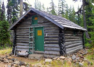
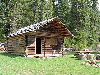
WThe Imnaha Guard Station is a rustic cabin located in the Rogue River-Siskiyou National Forest in western Oregon, United States. It was originally built to house fire crews assigned to patrol the surrounding National Forest. In the 1990s, the United States Forest Service began renting the Imnaha Guard Station to recreational visitors. The Imnaha Guard Station is listed on the National Register of Historic Places.
 W
WIsland Lake is one of many small alpine lakes in the southern Cascade Range in the U.S. state of Oregon. Part of the Rogue River watershed, it is 29 miles (47 km) northwest of Klamath Falls at an elevation of about 6,000 feet (1,800 m) above sea level. It is one of the largest of the more than 200 bodies of water in the Sky Lakes Wilderness, which straddles the crest of the Cascades.
 W
WKalmiopsis Wilderness is a wilderness area in the Klamath Mountains of southwestern Oregon, within the Rogue River – Siskiyou National Forest. It was designated wilderness by the United States Congress in 1964 and now comprises a total of 179,755 acres (72,744 ha). There are approximately 153 miles (246 km) of trails on 24 established hiking trails in the area.
 W
WThe Klamath Basin is the region in the U.S. states of Oregon and California drained by the Klamath River. It contains most of Klamath County and parts of Lake and Jackson counties in Oregon, and parts of Del Norte, Humboldt, Modoc, Siskiyou, and Trinity counties in California. The 15,751-square-mile (40,790 km2) drainage basin is 35% in Oregon and 65% in California. In Oregon, the watershed typically lies east of the Cascade Range, while California contains most of the river's segment that passes through the mountains. In the Oregon-far northern California segment of the river, the watershed is semi-desert at lower elevations and dry alpine in the upper elevations. In the western part of the basin, in California, however, the climate is more of temperate rainforest, and the Trinity River watershed consists of a more typical alpine climate.
 W
WThe Klamath River flows 257 miles (414 km) through Oregon and northern California in the United States, emptying into the Pacific Ocean. By average discharge, the Klamath is the second largest river in California after the Sacramento River. It drains an extensive watershed of almost 16,000 square miles (41,000 km2) that stretches from the arid country of south-central Oregon to the temperate rainforest of the Pacific coast. Unlike most rivers, the Klamath begins in the high desert and flows toward the mountains – carving its way through the rugged Cascade Range and Klamath Mountains before reaching the sea. The upper basin, today used for farming and ranching, once contained vast freshwater marshes that provided habitat for abundant wildlife, including millions of migratory birds. Most of the lower basin remains wild, with much of it designated wilderness. The watershed is known for this peculiar geography, and the Klamath has been called "a river upside down" by National Geographic magazine.
 W
WLewisia cotyledon is a species of flowering plant in the family Montiaceae known by the common names Siskiyou lewisia and cliff maids. It is native to southern Oregon and northern California, where it grows in rocky subalpine mountain habitat.
 W
WThe Lookout Air Raids were minor but historic Japanese air raids that occurred in the mountains of Oregon, several miles outside Brookings during World War II.
WMount Emily is a mountain in the Klamath Mountains of southwestern Oregon in the United States. It is located in southern Curry County in the extreme southwest corner of the state, near Brookings, approximately 5 miles (8.0 km) from the Pacific Ocean and 5 miles (8.0 km) from the California state line.
 W
WThe North Fork Smith River is 28-mile (45 km) tributary of the Smith River that begins in the U.S. state of Oregon and ends in the U.S. state of California. Arising near Chetco Peak in the Klamath Mountains, it flows generally south to meet the Middle Fork Smith River at Gasquet, California. The combined streams form the Smith River.
 W
WThe Red Buttes Wilderness is a wilderness area in the Klamath and Rogue River national forests in the U.S. states of Oregon and California. It comprises 19,940 acres (8,070 ha), approximately 16,190 acres (6,550 ha) of which is located in California, and 3,750 acres (1,520 ha) in Oregon. It was established by the California Wilderness Act of 1984 and the Oregon Wilderness Act of 1984.
 W
WThe Rogue River in southwestern Oregon in the United States flows about 215 miles (346 km) in a generally westward direction from the Cascade Range to the Pacific Ocean. Known for its salmon runs, whitewater rafting, and rugged scenery, it was one of the original eight rivers named in the Wild and Scenic Rivers Act of 1968. Beginning near Crater Lake, which occupies the caldera left by the explosive volcanic eruption and collapse of Mount Mazama, the river flows through the geologically young High Cascades and the older Western Cascades, another volcanic province. Further west, the river passes through multiple exotic terranes of the more ancient Klamath Mountains. In the Kalmiopsis Wilderness section of the Rogue basin are some of the world's best examples of rocks that form the Earth's mantle. Near the mouth of the river, the only dinosaur fragments ever discovered in Oregon were found in the Otter Point Formation, along the coast of Curry County.
 W
WThe Rogue–Umpqua Divide Wilderness is a wilderness area located in the Rogue River – Siskiyou and Umpqua National Forests in the Klamath Mountains of Oregon, United States. It was established by the United States Congress in 1984 and comprises 33,200 acres (13,400 ha).
 W
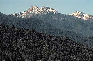
WThe Siskiyou Mountains are a coastal subrange of the Klamath Mountains, and located in northwestern California and southwestern Oregon in the United States. They extend in an arc for approximately 100 miles (160 km) from east of Crescent City, California, northeast along the north side of the Klamath River into Josephine and Jackson counties in Oregon. The mountain range forms a barrier between the watersheds of the Klamath River to the south and the Rogue River to the north.
WThe Siskiyou Wilderness is a federal wilderness area designated by the passage of the California Wilderness Act of 1984. Originally, the land area was 153,000 acres (620 km2) The Northern California Wild Heritage Act of 2006 added 30,122 acres (121.90 km2) for the current total of 182,802 acres (739.77 km2). All of the wilderness is in Northern California and is managed by the U.S. Forest Service. The wilderness spans three national forests: the Rogue River–Siskiyou, the Klamath, and the Six Rivers.
 W
WThe Sky Lakes Wilderness is a wilderness area located in the Rogue River–Siskiyou and Fremont–Winema national forests in the southern Cascade Range of Oregon in the United States. It comprises 116,300 acres (47,100 ha), of which 75,695 acres (30,633 ha) are in the Rogue River–Siskiyou National Forest and 40,605 acres (16,432 ha) are in the Fremont–Winema National Forest. It was established in 1984 under the Wilderness Act of 1964.
 W
WThe Smith River is a river flowing from the Klamath Mountains to the Pacific Ocean in Del Norte County in extreme northwestern California, on the West Coast of the United States. It is about 25.1 miles (40.4 km) long, all within Del Norte County, and it flows through the Rogue River – Siskiyou National Forest, Six Rivers National Forest, and Jedediah Smith Redwoods State Park.
 W
WThe Wild Rogue Wilderness is a wilderness area surrounding the 84-mile (135 km) Wild and Scenic portion of the Rogue River in southwestern Oregon, U.S. to protect the watershed. The wilderness was established in 1987 and now comprises 35,818 acres (14,495 ha). Because it spans part of the Rogue River-Siskiyou National Forest as well as the Medford district of the Bureau of Land Management (BLM), the Wild Rogue Wilderness is administered by both the BLM and the Forest Service.
 W
WThe Willow Prairie Cabin is a rustic one-room cabin located in the Rogue River-Siskiyou National Forest in western Oregon, United States. It was built by a road construction crew in 1924. When the road was finished the United States Forest Service began using it to house fire crews assigned to patrol the surrounding National Forest. The Forest Service now rents the cabin to recreational visitors. The Willow Prairie Cabin is listed on the National Register of Historic Places.