 W
WThe Southeastern Ceremonial Complex, aka S.E.C.C., is the name given to the regional stylistic similarity of artifacts, iconography, ceremonies, and mythology of the Mississippian culture. It coincided with their adoption of maize agriculture and chiefdom-level complex social organization from 1200 to 1650 CE. Due to some similarities between S.E.C.C. and contemporary Mesoamerican cultures, scholars from the late 1800s to mid-1900s suspected there was a connection between the two locations. But, later research indicates the two cultures have no direct links and that their civilizations developed independently.
 W
WAnishinaabe traditional beliefs cover the traditional belief system of the Anishinaabeg peoples, consisting of the Algonquin/Nipissing, Ojibwa/Chippewa/Saulteaux/Mississaugas, Odawa, Potawatomi and Oji-Cree, located primarily in the Great Lakes region of North America.
 W
WThe Bad River LaPointe Band of the Lake Superior Tribe of Chippewa Indians are a federally recognized tribe of Ojibwe people. The Bad River Reservation is located on the south shore of Lake Superior and has a land area of 156,000 acres in northern Wisconsin straddling Ashland and Iron counties. The tribe has approximately 7,000 members, of whom about 1,800 lived on the reservation during the 2000 census.
 W
WBlack Hawk, born Ma-ka-tai-me-she-kia-kiak, was a band leader and warrior of the Sauk Native American tribe in what is now the Midwest of the United States. Although he had inherited an important historic sacred bundle from his father, he was not a hereditary civil chief. Black Hawk earned his status as a war chief or captain by his actions: leading raiding and war parties as a young man and then a band of Sauk warriors during the Black Hawk War of 1832.
 W
WThe Black Hawk Powwow Grounds are located in Komensky, Wisconsin. In 2007, the site was added to the National Register of Historic Places.
 W
WThe Black Hawk War was a brief conflict between the United States and Native Americans led by Black Hawk, a Sauk leader. The war erupted soon after Black Hawk and a group of Sauks, Meskwakis, and Kickapoos, known as the "British Band", crossed the Mississippi River, into the U.S. state of Illinois, from Iowa Indian Territory in April 1832. Black Hawk's motives were ambiguous, but he was apparently hoping to avoid bloodshed while resettling on tribal land that had been colonized by the United States in the disputed 1804 Treaty of St. Louis.
 W
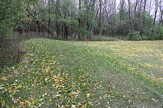
WCalumet County Park Group is an archaeological site in Calumet County, Wisconsin, United States. It consists of six effigy mounds of panthers and other water spirits and it is located at the top of the Niagara Escarpment where overlook Lake Winnebago. The group is located within the Calumet County Park approximately 2 miles northwest of Stockbridge. The mounds are consistent with other mound groups found at the peak of the Niagara Escarpment along the eastern shore of Lake Winnebago, including the High Cliff Mounds. It was listed on the National Register of Historic Places in 1997.
 W
WThe End of the Trail is a sculpture by James Earle Fraser located in Waupun, Wisconsin, United States. It depicts a weary Native American man hanging limp as his weary horse comes to the edge of the Pacific Ocean. The statue is a commentary on the damage Euro-American settlement inflicted upon Native Americans. The main figure embodies the suffering and exhaustion of people driven from their native lands.
 W
WThe Gee's Slough Group of Indian Mounds, located along the Lemonweir River just outside of New Lisbon, Wisconsin, is listed on the US National Register of Historic Places. The New Lisbon area was a winter gathering place for the Woodland Culture Indians who are considered the ancestors to the Ho-Chunk (Winnebago) tribe.
 W
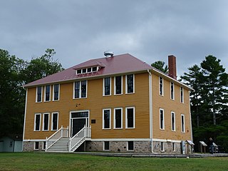
WThe Government Boarding School at Lac du Flambeau in Lac du Flambeau, Wisconsin was a school where native American children - mostly Ojibwe - were taken from their families and their culture and taught mainstream American culture from 1895 to 1932. It was added to the National Register of Historic Places in 2005.
 W
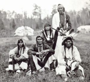
WHanging Cloud was an Ojibwe woman who was a full warrior among her people, and claimed by the Wisconsin Historical Society as the only woman to ever become one. She was the daughter of Chief Nenaa'angebi and his wife Niigi'o. Aazhawigiizhigokwe was of the Makwa-doodem, and was born and lived most of her life at Rice Lake, Wisconsin. Her community became part of the Lac Courte Oreilles Band of Lake Superior Chippewa Indians after the 1854 Treaty of La Pointe.
 W
WHigh Cliff State Park is a 1,187-acre (480 ha) Wisconsin state park near Sherwood, Wisconsin. It is the only state-owned recreation area located on Lake Winnebago. The park got its name from cliffs of the Niagara Escarpment, a land formation east of the shore of Lake Winnebago that stretches north through northeast Wisconsin, Upper Michigan, and Ontario to Niagara Falls and New York State.
 W
WDuring the War of 1812, the Illinois Territory was the scene of fighting between Native Americans and United States soldiers and settlers. The Illinois Territory at that time included the areas of modern Illinois, Wisconsin and parts of Minnesota and Michigan.
 W
WWhitewater Effigy Mounds Preserve is a park operated by the city of Whitewater, Wisconsin. The 21.5-acre park is located on the west side of the city. It was added to the National Register of Historic Places in 1991.
 W
WSimon Kahquados, born Kakanisaiga, was a leader of the Potawatomi people in Wisconsin and played a pivotal role in creating the federally recognized Forest County Potawatomi Community.
 W
WChief Buffalo was a major Ojibwa leader, born at La Pointe in Lake Superior's Apostle Islands, in what is now northern Wisconsin, USA.
 W
WLizard Mound County Park is a county-operated park in the Town of Farmington, Washington County, Wisconsin near the city of West Bend. Established in 1950, it was acquired by Washington County from the state of Wisconsin in 1986. It contains a significant well-preserved effigy mound group.
 W
WLutheran Indian Mission is a historic church in Gresham, Wisconsin, United States. The Mission church and school was built in 1901 by the Lutheran Church–Missouri Synod to serve Stockbridge Indians. The school operated until 1958 and the church continues today.
WMero Mound Group or Diamond Bluff Site is an archeological site near Diamond Bluff, Wisconsin, in Pierce County, Wisconsin. It consists of at least two village sites surrounded by hundreds of mounds, including three effigy mounds. All were constructed from around 1000 AD to 1300 AD.
 W
WThe Outlet Mound is an conical burial mound located at the outlet of Lake Monona - now near the junction of Midwood and Ridgewood Avenues in Monona, Wisconsin. It was added to the National Register of Historic Places in 2003.
 W
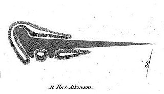
WThe Panther Intaglio Effigy Mound is a ground depression in Fort Atkinson, Wisconsin. The effigy is a reverse mound: a depression in the shape of a panther or water spirit scooped out by prehistoric Native Americans. In the mid-1800s ten of these reverse effigy mounds were found in Wisconsin, but all except this one have been destroyed. It was added to the National Register of Historic Places in 1970.
 W
WPontiac's War, also known as Pontiac's Conspiracy or Pontiac's Rebellion, was launched in 1763 by a loose confederation of American Indian tribes, primarily from the Great Lakes region, the Illinois Country, and Ohio Country who were dissatisfied with British policies in the Great Lakes region following the French and Indian War (1754–1763). Warriors from numerous tribes joined the uprising in an effort to drive British soldiers and settlers out of the region. The war is named after Odawa leader Pontiac, the most prominent of many Indian leaders in the conflict.
 W
WThe Potawatomi Trail of Death was the forced removal by militia in 1838 of some 859 members of the Potawatomi nation from Indiana to reservation lands in what is now eastern Kansas. The march began at Twin Lakes, Indiana on September 4, 1838, and ended on November 4, 1838, along the western bank of the Osage River, near present-day Osawatomie, Kansas. During the journey of approximately 660 miles (1,060 km) over 61 days, more than 40 persons died, most of them children. It marked the single largest Indian removal in Indiana history.
 W
WRed Cliff Band of Lake Superior Chippewa is a band of Ojibwe Native Americans. The Red Cliff Band is located on the Red Cliff Indian Reservation, on Lake Superior in Bayfield County, Wisconsin. Red Cliff, Wisconsin, is the administrative center. Red Cliff is notable for being the band closest to the spiritual center of the Ojibwe nation, Madeline Island. The reservation is located in the Town of Russell and the Town of Bayfield, north and northwest of the city of Bayfield, Wisconsin.
 W
WThe Saint Joseph of the Lake Church is located on the Menominee Indian Reservation in Menominee County, Wisconsin. It was added to the National Register of Historic Places in 2000.
 W
WSamuels' Cave, also known as Brown's Cave, Pictured Cave, or Mystery Cave, is a prehistoric, naturally formed rock shelter located in La Crosse County, Wisconsin. The cave contains petroglyphs and pictographs from the Native Americans who lived in the area. It was listed on the National Register of Historic Places in 1991.
 W
WThe Sheboygan Indian Mound Park is a public park in Sheboygan, Wisconsin. Its main attraction is 18 Indian burial mounds distributed over 15 acres. The Kletzien Mound Group, located within the park, was added to the National Register of Historic Places in 1981. While the park is operated by the City of Sheboygan, it is surrounded by the Town of Wilson in a residential neighborhood. The park is protected under the Wisconsin Burial Sites Preservation Law.
 W
WThe St. John Mine is located in Potosi, Wisconsin. It was added to the National Register of Historic Places in 1979.
 W
WTainter Cave, also known as Tombstone Cave, is a dry sandstone cave in Crawford County, Wisconsin, in which prehistoric Native Americans carved petroglyphs and drew pictographs, including birds, men, deer, and abstract designs. With over 100 pictographs, the cave holds more than any other known site in Wisconsin. It is also notable as the first archaeological site recorded in the dark zone of a cave in the Upper Midwest.
 W
WThe Treaty of Chicago may refer to either of two treaties made and signed in the settlement that became Chicago, Illinois between the United States and the Odaawaa, Ojibwe, and Bodéwadmi Native American peoples. The first was in 1821 and the second in 1833.
 W
WThe Treaty of La Pointe may refer to either of two treaties made and signed in La Pointe, Wisconsin between the United States and the Ojibwe (Chippewa) Native American peoples. In addition, the Isle Royale Agreement, an adhesion to the first Treaty of La Pointe, was made at La Pointe.
 W
WThe Upper Mississippian cultures were located in the Upper Mississippi basin and Great Lakes region of the American Midwest. They were in existence from approximately A.D. 1000 until the Protohistoric and early Historic periods.
 W
WThe Western Confederacy, or Western Indian Confederacy, was a loose confederacy of Native Americans in the Great Lakes region of the United States created following the American Revolutionary War. Formally, the confederacy referred to itself as the United Indian Nations, at their Confederate Council. It is also known as the Miami Confederacy, since many contemporaneous federal officials overestimated the influence and numerical strength of the Miami tribes based on the size of their principle city, Kekionga. The confederacy, which had its roots in pan-tribal movements dating to the 1740s, formed in an attempt to resist the expansion of the United States and the encroachment of American settlers into the Northwest Territory after Great Britain ceded the region to the U.S. in the 1783 Treaty of Paris. This resulted in the Northwest Indian War (1785–1795), in which the Confederacy won significant victories over the United States, but concluded with an U.S. victory at the Battle of Fallen Timbers. The Confederacy became fractured and agreed to peace with the United States, but the pan-tribal resistance was later rekindled by Tenskwatawa and his brother, Tecumseh.
 W
WWhitefish Dunes State Park is a 867-acre (351 ha) state park of Wisconsin, United States, on the eastern shore of the Door Peninsula. This day-use park preserves the most substantial sand dunes on the western shore of Lake Michigan. The remains of eight successive prehistoric Native American villages are on the National Register of Historic Places as Whitefish Dunes-Bay View Site. Cave Point County Park is an enclave inside the state park, allowing visitors free foot access to the state park by the shoreline trail connecting the parks.