 W
WThe geology of Mars is the scientific study of the surface, crust, and interior of the planet Mars. It emphasizes the composition, structure, history, and physical processes that shape the planet. It is analogous to the field of terrestrial geology. In planetary science, the term geology is used in its broadest sense to mean the study of the solid parts of planets and moons. The term incorporates aspects of geophysics, geochemistry, mineralogy, geodesy, and cartography. A neologism, areology, from the Greek word Arēs (Mars), sometimes appears as a synonym for Mars's geology in the popular media and works of science fiction.
 W
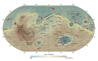
WAcross the southern highlands of Mars, approximately 640 sites of chloride-bearing deposits have been identified using the Thermal Emission Imaging System (THEMIS). These isolated, irregularly shaped patches have been dated to the older geologic periods on Mars: Noachian and Hesperian periods. On Earth, chlorides are known to form through aqueous processes. Similar processes are expected to be responsible for the formation of chloride deposits on Mars. The finding of these deposits is significant in that it provides further evidence for the presence of surface or subsurface water in ancient Mars.
 W
WThe composition of Mars covers the branch of the geology of Mars that describes the make-up of the planet Mars.
 W
WDark slope streaks are narrow, avalanche-like features common on dust-covered slopes in the equatorial regions of Mars. They form in relatively steep terrain, such as along escarpments and crater walls. Although first recognized in Viking Orbiter images from the late 1970s, dark slope streaks were not studied in detail until higher-resolution images from the Mars Global Surveyor (MGS) and Mars Reconnaissance Orbiter (MRO) spacecraft became available in the late 1990s and 2000s.
 W
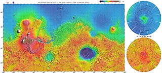
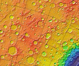
WThe most conspicuous feature of Mars is a sharp contrast, known as the Martian dichotomy, between the Southern and the Northern hemispheres. The two hemispheres' geography differ in elevation by 1 to 3 km. The average thickness of the Martian crust is 45 km, with 32 km in the northern lowlands region, and 58 km in the southern highlands.
 W
WMany areas on Mars experience the passage of giant dust devils. These dust devils leave tracks on the surface of Mars because they disturb a thin coating of fine bright dust that covers most of the Martian surface. When a dust devil goes by it blows away the coating and exposes the underlying dark surface. Within a few weeks, the dark track assumes its former bright colour, either by being re-covered through wind action or due to surface oxidation through exposure to sunlight and the Martian atmosphere.
 W
WEnipeus Vallis is a valley in the northern hemisphere of the planet Mars. It is centered at lat. 37°N, long. 267°E in the Arcadia quadrangle (MC-3) between the large volcano Alba Mons and the Tempe Terra plateau. The valley follows a gently sinuous, north-south path for a distance of about 357 km (222 mi). It is likely an ancient watercourse that formed during the early Hesperian period, around 3.7 billion years ago.
 W
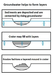
WEquatorial Layered Deposits (ELD’s) have been called Interior Layered Deposits (ILDs) in Valles Marineris. They are often found with the most abundant outcrops of hydrated sulfates on Mars, and thus are likely to preserve a record of liquid water in Martian history since hydrated sulfates are formed in the presence of water. Layering is visible on meter scale, and when the deposits are partly eroded, intricate patterns become visible. The layers in the mound in Gale Crater have been extensively studied from orbit by instruments on the Mars Reconnaissance Orbiter. The Curiosity Rover landed in the crater, and it has brought some ground truth to the observations from satellites. Many of the layers in ELD’s such as in Gale Crater are composed of fine-grained, easily erodible material as are many other layered deposits. On the basis of albedo, erosion patterns, physical characteristics, and composition, researchers have classified different groups of layers in Gale Crater that seem to be similar to layers in other (ELD’s). The groups include: a small yardang unit, a coarse yardang unit, and a terraced unit. Generally, equatorial layered deposits are found ~ ±30° of the equator. Equatorial Layered Deposits appear in various geological settings such as cratered terrains, chaotic terrains, the Valles Marineris chasmata, and large impact craters.
 W
WThe geological history of Mars follows the physical evolution of Mars as substantiated by observations, indirect and direct measurements, and various inference techniques. Methods dating back to 17th century techniques developed by Nicholas Steno, including the so-called law of superposition and stratigraphy, used to estimate the geological histories of Earth and the Moon, are being actively applied to the data available from several Martian observational and measurement resources. These include the landers, orbiting platforms, Earth-based observations, and Martian meteorites.
 W
WMartian geysers are putative sites of small gas and dust eruptions that occur in the south polar region of Mars during the spring thaw. "Dark dune spots" and "spiders" – or araneiforms – are the two most visible types of features ascribed to these eruptions.
 W
WGlaciers, loosely defined as patches of currently or recently flowing ice, are thought to be present across large but restricted areas of the modern Martian surface, and are inferred to have been more widely distributed at times in the past. Lobate convex features on the surface known as viscous flow features and lobate debris aprons, which show the characteristics of non-Newtonian flow, are now almost unanimously regarded as true glaciers.
 W
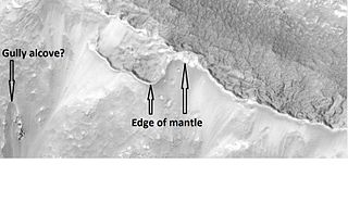
WMartian gullies are small, incised networks of narrow channels and their associated downslope sediment deposits, found on the planet of Mars. They are named for their resemblance to terrestrial gullies. First discovered on images from Mars Global Surveyor, they occur on steep slopes, especially on the walls of craters. Usually, each gully has a dendritic alcove at its head, a fan-shaped apron at its base, and a single thread of incised channel linking the two, giving the whole gully an hourglass shape. They are estimated to be relatively young because they have few, if any craters. A subclass of gullies is also found cut into the faces of sand dunes, that are themselves considered to be quite young. Linear dune gullies are now considered recurrent seasonal features.
 W
WThe Heat Flow and Physical Properties Package (HP3) is a science payload on board the InSight lander that features instruments to study the heat flow and other thermal properties of Mars. One of the instruments, a burrowing probe nicknamed "the mole", is designed to penetrate 5 m (16 ft) below Mars' surface. In March 2019, the mole burrowed a few centimeters, but then became unable to make progress due to various scenarios. In the following year further efforts were made to resolve the issues. As of June 2020, the top of the mole is flush with the martian regolith and burrowing efforts are ongoing.
 W
WThe Interior Exploration using Seismic Investigations, Geodesy and Heat Transport (InSight) mission is a robotic lander designed to study the deep interior of the planet Mars. It was manufactured by Lockheed Martin Space Systems, is managed by NASA's Jet Propulsion Laboratory, and most of its scientific instruments were built by European agencies. The mission launched on 5 May 2018 at 11:05 UTC aboard an Atlas V-401 rocket and successfully landed at Elysium Planitia on Mars on 26 November 2018 at 19:52:59 UTC. InSight traveled 483 million km (300 million mi) during its journey.
 W
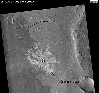
WA new class of Martian impact craters have been discovered by Northern Arizona University scientist Prof Nadine Barlow and Dr Joseph Boyce from the University of Hawaii in Oct 2013. They have termed it as ‘low-aspect-ratio layered ejecta (LARLE) craters’. Prof Nadine Barlow, a scientist Northern Arizona University described this class of craters with “thin-layered outer deposit” surpassing “the typical range of ejecta”. “The combination helps vaporize the materials and create a base flow surge. The low aspect ratio refers to how thin the deposits are relative to the area they cover,” Prof Barlow said. The scientists used data from continuing reconnaissance of Mars using the old Mars Odyssey Orbiter and the Mars Reconnaissance Orbiter, discovered 139 LARLE craters ranging in diameter from 1.0 to 12.2 km, with 97 per cent of the LARLE craters are found poleward of 35N and 40S, while remaining mainly traced in the equatorial Medusae Fossae Formation.
 W
WMuch of the Martian surface is covered with a thick ice-rich, mantle layer that has fallen from the sky a number of times in the past. In some places a number of layers are visible in the mantle.
 W
WLineated valley fill (LVF), also called lineated floor deposit, is a feature of the floors of some channels on Mars, exhibiting ridges and grooves that seem to flow around obstacles. Shadow measurements show that at least some of the ridges are several metres high. LVF is believed to be ice-rich. Hundreds of metres of ice probably lie protected in LVF under a thin layer of debris. The debris consists of wind-borne dust, material from alcove walls, and lag material remaining after ice sublimated from a rock-ice mixture. Some glaciers on Earth show similar ridges. High-resolution pictures taken with HiRISE reveal that some of the surfaces of lineated valley fill are covered with strange patterns called closed-cell and open-cell brain terrain. The terrain resembles a human brain. It is believed to be caused by cracks in the surface accumulating dust and other debris, together with ice sublimating from some of the surfaces. The cracks are the result stress from gravity and seasonal heating and cooling. This same type of surface is present on Lobate debris aprons and Concentric crater fill so all three are believed to be related.
 W
WLobate debris aprons (LDAs) are geological features on Mars, first seen by the Viking Orbiters, consisting of piles of rock debris below cliffs. These features have a convex topography and a gentle slope from cliffs or escarpments, which suggest flow away from the steep source cliff. In addition, lobate debris aprons can show surface lineations as do rock glaciers on the Earth.
 W
WA marsquake is a quake which, much like an earthquake, would be a shaking of the surface or interior of the planet Mars as a result of the sudden release of energy in the planet's interior, such as the result of plate tectonics, which most quakes on Earth originate from, or possibly from hotspots such as Olympus Mons or the Tharsis Montes. The detection and analysis of marsquakes could be informative to probing the interior structure of Mars, as well as identifying whether any of Mars's many volcanoes continue to be volcanically active or not.
 W
WMartian lava tubes are volcanic caverns on Mars that are believed to form as a result of fast-moving, basaltic lava flows associated with shield volcanism. Lava tubes usually form when the external surface of the lava channels cools more quickly and forms a hardened crust over subsurface lava flows. The flow eventually ceases and drains out of the tube, leaving a conduit-shaped void space which is usually several meters below the surface. Lava tubes are typically associated with extremely fluid pahoehoe lava. Gravity on mars is about 38% that of Earth's, allowing Martian lava tubes to be much larger in comparison.
 W
WIn January 2017, scientists announced the possible discovery of mud cracks in Gale Crater on Mars. The Curiosity Rover imaged what may be the first mud cracks ever found on Mars. They may have been formed from drying mud. The site, called “Old Soaker,” was within an exposure of Murray formation mudstone on lower Mount Sharp. It is hypothesized that these cracks formed more than 3 billion years ago and then were buried by more sediment. All this material eventually turned into rock. Later wind erosion removed the layers that covered the cracked layer. The cracks were filled with material which was resistant to later erosion. This erosion resistant material formed raised ridges, as some of the surrounding layer was removed. This is the first sighting of mud cracks. Previously, Curiosity has examined cracks and ridges of different shapes that were made by groundwater carrying minerals, such as calcium sulfate. Cracks for this process were caused by the pressure of overlying sediments fracturing rock. Gale Crater held ancient lakes that varied in depth and area over time, and sometimes disappeared. Mud cracks show that there were dry times when lakes disappeared. Besides this evidence of mud, Curiosity has found evidence of ancient lakes in older layers and also in younger mudstone. Nathan Stein, a graduate student at the California Institute of Technology led the investigation.
 W
WThe Murray Formation is the name given to a distinctive mudstone geologic formation studied by the Mars Science Laboratory (MSL) Curiosity at the Gale Crater, Mars.
 W
WNilokeras Scopulus is a long escarpment (cliff) in the northern hemisphere of the planet Mars. It is located along the southeastern boundary of the Tempe Terra plateau and forms the northern valley wall of the downstream portion of the immense Kasei Valles outflow channel system. The escarpment is 765 km long and ranges from 1 to a little over 2 km (3300–6600 ft) in height.
 W
WThe Noachian is a geologic system and early time period on the planet Mars characterized by high rates of meteorite and asteroid impacts and the possible presence of abundant surface water. The absolute age of the Noachian period is uncertain but probably corresponds to the lunar Pre-Nectarian to Early Imbrian periods of 4100 to 3700 million years ago, during the interval known as the Late Heavy Bombardment. Many of the large impact basins on the Moon and Mars formed at this time. The Noachian Period is roughly equivalent to the Earth's Hadean and early Archean eons when the first life forms likely arose.
WThe Noachian is a geologic system and early time period on the planet Mars characterized by high rates of meteorite and asteroid impacts and the possible presence of abundant surface water. The absolute age of the Noachian period is uncertain but probably corresponds to the lunar Pre-Nectarian to Early Imbrian periods of 4100 to 3700 million years ago, during the interval known as the Late Heavy Bombardment. Many of the large impact basins on the Moon and Mars formed at this time. The Noachian Period is roughly equivalent to the Earth's Hadean and early Archean eons when the first life forms likely arose.
 W
WPolygonal, patterned ground is quite common in some regions of Mars. It is commonly believed to be caused by the sublimation of ice from the ground. Sublimation is the direct change of solid ice to a gas. This is similar to what happens to dry ice on the Earth. Places on Mars that display polygonal ground may indicate where future colonists can find water ice. Low center polygons have been proposed as a marker for ground ice.
 W
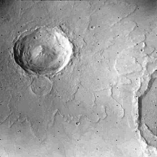
WRampart craters are a specific type of impact crater which are accompanied by distinctive fluidized ejecta features found mainly on Mars. There is one example known on Earth, the Nördlinger Ries impact structure in Germany. A rampart crater displays an ejecta with a low ridge along its edge. Usually, rampart craters show a lobate outer margin, as if material moved along the surface, rather than flying up and down in a ballistic trajectory. The flows sometimes are diverted around small obstacles, instead of falling on them. The ejecta look as if they move as a mudflow. Some of the shapes of rampart craters can be duplicated by shooting projectiles into mud. Although rampart craters can be found all over Mars, the smaller ones are only found in the high latitudes where ice is predicted to be close to the surface. It seems that the impact has to be powerful enough to penetrate to the level of the subsurface ice. Since ice is thought to be close to the surface in latitudes far from the equator, it does not take a large impact to reach the ice level. Based on images from the Viking program in the 1970s, it is generally accepted that rampart craters are evidence of ice or liquid water beneath the surface of Mars. The impact melts or boils the water in the subsurface producing a distinctive pattern of material surrounding the crater.
 W
WThe Seismic Experiment for Interior Structure (SEIS) is a seismometer and the primary scientific instrument on board the InSight Mars lander launched on 5 May 2018 for a landing on 26 November 2018; the instrument was deployed to the surface of Mars on 19 December. SEIS is expected to provide seismic measurements of marsquakes, enabling researchers to develop 3D structure maps of the deep interior. Better understanding the internal structure of Mars will lead to better understanding of the Earth, Moon, and rocky planetary bodies in general.
 W
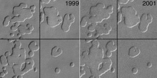
WSwiss cheese features (SCFs) are curious pits in the south polar ice cap of Mars named from their similarity to the holes in Swiss cheese. They were first seen in 2000 using Mars Orbiter Camera imagery.
 W
WLike the Earth, the crustal properties and structure of the surface of Mars are thought to have evolved through time; in other words, as on Earth, tectonic processes have shaped the planet. However, both the ways this change has happened and the properties of the planet's lithosphere are very different when compared to the Earth. Today, Mars is believed to be largely tectonically inactive. However, observational evidence and its interpretation suggests that this was not the case further back in Mars' geological history.
 W
WThe landscape polewards of around 30 degrees latitude on Mars has a distinctively different appearance to that nearer the equator, and is said to have undergone terrain softening. Softened terrain lacks the sharp ridge crests seen near the equator, and is instead smoothly rounded. This rounding is thought to be caused by high concentrations of water ice in soils. The term was coined in 1986 by Steve Squyres and Michael Carr from examining imagery from the Viking missions to Mars.
 W
WIn planetary nomenclature, a tholus is a small domical mountain or hill. The word is from the Greek θόλος, tholos, which means a circular building with a conical or vaulted roof. The Romans transliterated the word into the Latin tholus, which means cupola or dome. In 1973, the International Astronomical Union (IAU) adopted tholus as one of a number of official descriptor terms for topographic features on Mars and other planets and satellites. One justification for using neutral Latin or Greek descriptors was that it allowed features to be named and described before their geology or geomorphology could be determined. For example, many tholi appear to be volcanic in origin, but the term does not imply a specific geologic origin. Currently, the IAU recognizes 56 descriptor terms. Tholi are present on Venus, Mars, asteroid 4 Vesta and on Jupiter's moon Io.
 W
WFor some time, scientists have thought that the location of the poles of Mars have shifted due to the great mass of volcanic material in the Tharsis dome which includes Olympus Mons, the highest volcano in the solar system. A study published in Nature supports this idea. For a period early in the history of Mars, the poles were about 20 degrees away from their present positions. At that time ice was deposited in a region called Dorsa Argentea Formation. Also, the Martian dichotomy was aligned along the equator. A band of rivers formed at around 25 degrees south carried water from the southern highlands to the northern lowlands. After the polar shift, the location of the dichotomy boundary and the band of river valleys shifted. Dorsa Argentea was no longer at the pole. To produce the change in the pole location, the tilt of the planet remained unchanged, rather the crust and mantle moved. They rotated around the core. This new study suggests that the volcanoes and the movement of the poles occurred at about the same time. Volcanoes were erupting when the rivers were flowing with water. Perhaps the volcanoes supplied much water to the atmosphere, as well as carbon dioxide to warm the atmosphere; these effects would provide water for the rivers.
 W
WYardangs are common in some regions on Mars, especially in the Medusae Fossae Formation. This formation is found in the Amazonis quadrangle and near the equator. They are formed by the action of wind on sand sized particles; hence they often point in the prevailing direction that the winds were blowing when they were formed. Because they exhibit very few impact craters they are believed to be relatively young. The easily eroded nature of the Medusae Fossae Formation suggests that it is composed of weakly cemented particles, and was most likely formed by the deposition of wind-blown dust or volcanic ash. Yardangs are parts of rock that have been sand blasted into long, skinny ridges by bouncing sand particles blowing in the wind. Layers are seen in parts of the formation. A resistant caprock on the top of yardangs has been observed in Viking, Mars Global Surveyor, and HiRISE photos. Images from spacecraft show that they have different degrees of hardness probably because of significant variations in the physical properties, composition, particle size, and/or cementation.