 W
WIn geology, a depression is a landform sunken or depressed below the surrounding area. Depressions form by various mechanisms.
 W
WAoukar or Erg Aoukar is a geological depression area of south eastern Mauritania. It is located between Kiffa and Néma, south of the Tagant Plateau. The Aoukar basin is a dry natural region of sand dunes and salt pans fringed by escarpments on its northern and eastern sides.
 W
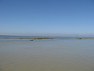
WA beel is a billabong or a lake-like wetland with static water (as opposed to moving water in rivers and canals - typically called khaals in Bengali, in the Ganges - Brahmaputra flood plains of the Eastern Indian states of West Bengal, and Assam and in the country of Bangladesh. The term owes its origins to the word of the same pronunciation meaning "pond" and "lake" in the Bengali and Assamese languages.
 W
WThe Bentley Subglacial Trench is a vast topographic trench in Marie Byrd Land, West Antarctica, 80°S, 115°W. At 2,555 meters (8,382 ft) below sea level, it is among the lowest points on the surface of the Earth not covered by ocean, although it is covered by ice..
 W
WBlowouts are sandy depressions in a sand dune ecosystem (psammosere) caused by the removal of sediments by wind.
 W
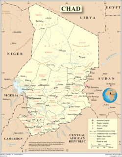
WThe Bodélé Depression, located at the southern edge of the Sahara Desert in north central Africa, is the lowest point in Chad. Its bottom lies about 155 meters above sea level. The dry endorheic basin is a major source of fertile dust essential for the Amazon rainforest.
 W
WA buffalo wallow or bison wallow is a natural topographical depression in the flat prairie land that holds rain water and runoff.
 W
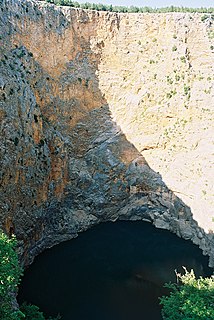
WA sinkhole, also known as a cenote, sink, sink-hole, swallet, swallow hole, or doline, is a depression or hole in the ground caused by some form of collapse of the surface layer. Most are caused by karst processes – the chemical dissolution of carbonate rocks or suffosion processes. Sinkholes vary in size from 1 to 600 m both in diameter and depth, and vary in form from soil-lined bowls to bedrock-edged chasms. Sinkholes may form gradually or suddenly, and are found worldwide.
 W
WA cryptodepression is a depression in the Earth's surface that is below mean sea level, and which is filled by a lake. The term is derived from the Ancient Greek word κρύπτoς ('hidden') and depression.
 W
WThe Darvaza gas crater, also known as the Door to Hell or Gates of Hell, is a natural gas field collapsed into a cavern located in Derweze, Turkmenistan.
 W
WAn endorheic lake, or sink lake, is a collection of water within an endorheic basin, or sink, with no evident outlet. Endorheic lakes are generally saline as a result of being unable to get rid of solutes left in the lake by evaporation. These lakes can be used as indicators of anthropogenic change, such as irrigation or climate change, in the areas surrounding them. Lakes with subsurface drainage are considered cryptorheic.
 W
WGeorge VI Sound or Canal Jorge VI or Canal Presidente Sarmiento or Canal Seaver or King George VI Sound or King George the Sixth Sound is a major bay/fault depression, 300 miles (483 km) long and mainly covered by a permanent ice shelf. It is in the shape of the letter J without any upper bar. It lines the east and south shores of Alexander Island, separating it from the vestigial, quite small, Wordie Ice Shelf and Palmer Land and the north-facing "English Coast". A quite central point of it is 71°S 68°W.
 W
WThe Gowd-i zerrah, i.e., Zerrah Depression is the lowest part of an inland drainage basin covering large parts of southern Afghanistan and Iran known as the Sistan Basin. The Sistan Basin is an endorheic basin and encompasses a complex system of rivers, shallow lakes, marshes and wetlands as its watershed, draining into the Hamun Lakes in southeastern Iran. Occasional outflows from these lakes are carried back into Afghanistan by the seasonal Shile river to the basin's terminus, the Godzareh depression in Afghanistan. The depression is flat and very shallow with fine textured sediment at its lowest portions. The lowest section of the Godzareh depression is 467 m above sea level. The depression only receives runoff water when the main tributaries are overflowing every 10 years on the average.
 W
WHamun-e Jaz Murian is an inland basin or depression in southeast Iran, straddling the provinces of Kerman and Sistan and Baluchistan. At the center of the basin is a "seasonal lake," or hamun. The lake can remain almost totally dry during dry years, while in wetter years it can have water year around. The most recent flooding of the basin took place in June 2007, when Cyclone Gonu dumped over 5 inches of rain over the basin. That ended years of unusual drought, which had seen the lake in the central basin remain dry for several years. Jaz Murian now has a large lake at its lowest point.
 W
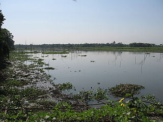
WA haor, is a wetland ecosystem in the north eastern part of Bangladesh which physically is a bowl or saucer shaped shallow depression, also known as a backswamp. During monsoon haors receive surface runoff water from rivers and canals to become vast stretches of turbulent water. They turn into a vast inland seas within which the villages appear as islands. Occasional high winds during the rainy season generate large waves in the haor, which may cause considerable damage to homesteads. However they all but dry up in the post-monsoon period. During winter, these haors are vast stretches of green land.
 W
WAn impact crater is an approximately circular depression in the surface of a planet, moon, or other solid body in the Solar System or elsewhere, formed by the hypervelocity impact of a smaller body. In contrast to volcanic craters, which result from explosion or internal collapse, impact craters typically have raised rims and floors that are lower in elevation than the surrounding terrain. Impact craters range from small, simple, bowl-shaped depressions to large, complex, multi-ringed impact basins. Meteor Crater is a well-known example of a small impact crater on Earth.
 W
WIsostatic depression is the sinking of large parts of the Earth's crust into the asthenosphere. The sinking is caused by a heavy weight placed on the Earth's surface. Often this is caused by the heavy weight of glacial ice due to continental glaciation. This is a process in which permanent ice places pressure on the Earth's crust, thereby depressing it with its weight. After continental glaciation has receded, it is common for isostatic rebound to occur.
 W
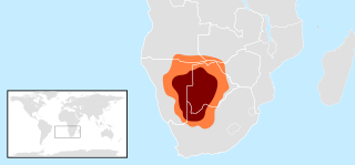
WThe Kalahari Basin, also known as the Kalahari Depression, Barotse Basin, or the Kalahari-Okavango Basin, is an endorheic basin and large lowland area covering over 2.5 million km2 covering most of Botswana and Namibia, as well as parts of Angola, South Africa, Zambia, and Zimbabwe. The outstanding physical feature in the basin, and occupying the centre, is the large Kalahari Desert.
 W
WA kettle is a depression/hole in an outwash plain formed by retreating glaciers or draining floodwaters. The kettles are formed as a result of blocks of dead ice left behind by retreating glaciers, which become surrounded by sediment deposited by meltwater streams as there is increased friction. The ice becomes buried in the sediment and when the ice melts, a depression is left called a kettle hole, creating a dimpled appearance on the outwash plain. Lakes often fill these kettles; these are called kettle hole lakes. Another source is the sudden drainage of an ice-dammed lake. When the block melts, the hole it leaves behind is a kettle. As the ice melts, ramparts can form around the edge of the kettle hole. The lakes that fill these holes are seldom more than 10 m (33 ft) deep and eventually become filled with sediment. In acid conditions, a kettle bog may form but in alkaline conditions, it will be kettle peatland.
 W
WLaguna Salada is a vast dry lake some 10 meters below sea level in the Sonoran Desert of Baja California, 30 km (19 mi) southwest of Mexicali. This lake was called "Ha wi mək" in Cocopah language and "Ha-sa-ai" in Kumeyaay language. The lake's shape vaguely resembles a rhombus. When dry, the flatness of the exposed lake bed sediments makes it a favoured location for recreational driving. It is also notorious for its dust storms, usually the result of monsoonal thunderstorms during the summer. During times of significant rain the lagoon can fill completely with water, leaving the unpaved road along its west bank as the only means of traversing the area. Flanked by the Sierra de Los Cucapah and the Sierra de Juárez mountain ranges, the lake is approximately 60 km (37 mi) long and 17 km (11 mi) at its widest point.
 W
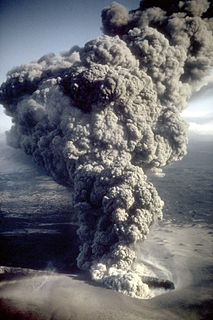
WA maar is a broad, low-relief volcanic crater caused by a phreatomagmatic eruption. A maar characteristically fills with water to form a relatively shallow crater lake which may also be called a maar. The name comes from a Moselle Franconian dialect word used for the circular lakes of the Daun area of Germany.
 W
WThe Mourdi Depression is a prominent desert depression of northeastern Chad. It lies adjacent to the Ennedi Plateau. The cleft lies "between the Erdi plateau and the eastern slopes of Ennedi, and the mouth of the Wadi Guroguro." The depression is characterized by a rocky valley, about 30 miles (48 km) wide from north to south, sloping from an altitude of about 1,800 feet (550 m) down towards the west to Djourab.
 W
WOceanic trenches are topographic depressions of the seafloor, relatively narrow in width, but very long. These oceanographic features are the deepest parts of the ocean floor. Oceanic trenches are a distinctive morphological feature of convergent plate boundaries, along which lithospheric plates move towards each other at rates that vary from a few millimeters to over ten centimeters per year. A trench marks the position at which the flexed, subducting slab begins to descend beneath another lithospheric slab. Trenches are generally parallel to a volcanic island arc, and about 200 km (120 mi) from a volcanic arc. Oceanic trenches typically extend 3 to 4 km below the level of the surrounding oceanic floor. The greatest ocean depth measured is in the Challenger Deep of the Mariana Trench, at a depth of 11,034 m (36,201 ft) below sea level. Oceanic lithosphere moves into trenches at a global rate of about 3 km2/yr.
 W
WOrcus Patera is a region on the surface of the planet Mars first photographed by Mariner 4. Of unknown formation, whether by volcanic, tectonic, or cratering causes, the region includes a depression about 380 kilometres long, 140 kilometres wide, surrounded by a rim up to 1.8 kilometres high.
 W
WA panhole is a shallow depression or basin eroded into flat or gently sloping cohesive rock. Confusingly, some authors refer to panholes also as potholes, which is a term typically used for similarly shaped riverine landforms. Similar terms for this feature are gnamma (Australia), armchair hollows, weathering pans and solution pans.
 W
WIn Earth science, a pothole is a smooth, bowl-shaped or cylindrical hollow, generally deeper than wide, found carved into the rocky bed of a watercourse. Other names used for riverine potholes are pot, (stream) kettle, giant's kettle, evorsion, hollow, rock mill, churn hole, eddy mill, and kolk. Although somewhat related to a pothole in origin, a plunge pool is the deep depression in a stream bed at the base of a waterfall. it is created by the erosional forces of turbulence generated by water falling on rocks at a waterfall's base where the water impacts. Potholes are also sometimes referred to as swirlholes. This word was created to avoid confusion with an English term for a vertical or steeply inclined karstic shaft in limestone. However, given widespread usage of this term for a type of fluvial sculpted bedrock landform, pothole is preferred in usage to swirlhole.
 W
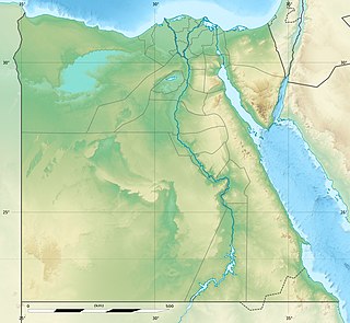
WThe Qattara Depression is a depression in northwestern Egypt, specifically in the Matruh Governorate. The depression is part of the Western Desert of Egypt. The Qattara Depression lies below sea level, and its bottom is covered with salt pans, sand dunes, and salt marshes. The depression extends between the latitudes of 28°35' and 30°25' north and the longitudes of 26°20' and 29°02' east.
 W
WA sag pond is a body of fresh water collected in the lowest parts of a depression formed between two sides of an active strike-slip, transtensional or normal fault zone.
 W
WA structural basin is a large-scale structural formation of rock strata formed by tectonic warping of previously flat-lying strata. Structural basins are geological depressions, and are the inverse of domes. Some elongated structural basins are also known as synclines. Structural basins may also be sedimentary basins, which are aggregations of sediment that filled up a depression or accumulated in an area; however, many structural basins were formed by tectonic events long after the sedimentary layers were deposited.
 W
WSubsidence is the sudden sinking or gradual downward settling of the ground's surface with little or no horizontal motion. The definition of subsidence is not restricted by the rate, magnitude, or area involved in the downward movement. It may be caused by natural processes or by human activities. The former include various karst phenomena, thawing of permafrost, consolidation, oxidation of organic soils, slow crustal warping, normal faulting, caldera subsidence, or withdrawal of fluid lava from beneath a solid crust. The human activities include sub-surface mining or extraction of underground fluids, e. g. petroleum, natural gas, or groundwater. Ground subsidence is of global concern to geologists, geotechnical engineers, surveyors, engineers, urban planners, landowners, and the public in general.
 W
WIn geology, a trough is a linear structural depression that extends laterally over a distance. Although it is less steep than a trench, a trough can be a narrow basin or a geologic rift. These features often form at the rim of tectonic plates. There are various oceanic troughs, troughs found under oceans.
 W
WThe Turpan Depression or Turfan Depression, is a fault-bounded trough located around and south of the city-oasis of Turpan, in the Xinjiang Autonomous Region in far Western China, about 150 kilometres (93 mi) southeast of the regional capital Ürümqi. It includes Lake Ayding, −154 metres (−505 ft), the second or third lowest depression on Earth. By some measures, it is also the hottest and driest area in China during the summer.
 W
WThe Upemba Depression is a large marshy bowl area (depression) in the Democratic Republic of the Congo comprising some fifty lakes, including 22 of relatively large size including Lake Upemba (530 km2) and Lake Kisale (300 km2). In an earlier era, the area was probably occupied by one large lake.
 W
WIn the Pays de Caux, Normandy, France a valleuse is a depression in the land surface of the plateau which permits access to the sea. On the rest of this coast, that access is prevented by the height of the chalk cliffs.