 W
WThe Conejo Valley is a region spanning both southeastern Ventura County and northwestern Los Angeles County in Southern California, United States. It is located in the northwestern part of the Greater Los Angeles Area.
 W
WAgoura Hills is a city in Los Angeles County, California. Its population was 20,330 at the 2010 census and an estimated 20,222 in 2019. It is in the eastern Conejo Valley between the Simi Hills and the Santa Monica Mountains. The city is in western Los Angeles County and is bordered to the north by Ventura County. It is 35 miles (56 km) northwest of Downtown Los Angeles and less than 10 miles (16 km) west of the Los Angeles city limits at Woodland Hills. Agoura Hills and unincorporated Agoura sit next to Calabasas, Oak Park, and Westlake Village.
 W
WAgoura is an unincorporated community of Los Angeles County, which is located southeast of the city of Agoura Hills, California, adjacent to the city of Calabasas in Los Angeles County. Agoura was the historical name of the area, before much of the area was developed and before the incorporation of the city of Agoura Hills. There are a few pockets of unincorporated areas, containing a handful of houses, in the area. Much of the area is also often referred to as the neighborhood of Old Agoura. The ZIP code is 91301 and the area codes are 747 and 818.
 W
WArroyo Conejo is the longest creek in the Conejo Valley, sprawling over the cities of Thousand Oaks and Camarillo, and the communities of Newbury Park, Casa Conejo and Santa Rosa Valley. Arroyo Conejo is the primary drainage for the City of Thousand Oaks. Its watershed covers 57 square miles (150 km2) of which 43 square miles (110 km2) are in the Conejo Valley and 14 square miles (36 km2) in the Santa Rosa Valley.
 W
WArroyo Conejo Open Space is a 302-acre (122 ha) open space reserve in the western Simi Hills in northern Newbury Park, Ventura County, California. Most of it is part of the 250-acre (100 ha) Arroyo Conejo Nature Preserve.
 W
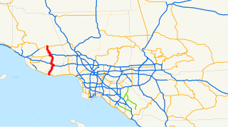
WState Route 23 is a state highway in the U.S. state of California that connects the Pacific coast and the Santa Monica Mountains to the Conejo and Santa Clara River valleys. It runs from Pacific Coast Highway in Malibu in Los Angeles County to Ventura Street in Fillmore in Ventura County.
 W
WCalifornia 26th congressional district is a congressional district in the U.S. state of California currently represented by Democrat Julia Brownley.
 W
WCalifornia's 27th State Senate district is one of 40 California State Senate districts. It is currently represented by Democrat Henry Stern of Malibu.
 W
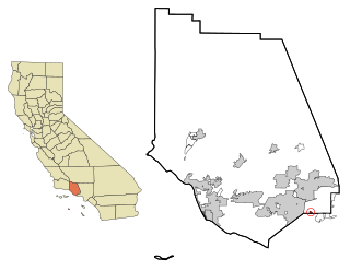
WCasa Conejo is an unincorporated county island in Newbury Park, Ventura County, California, United States. It was the first planned community in Newbury Park and began building in 1960. When the city of Thousand Oaks incorporated 4 years later, the new developments in Newbury Park were incorporated into the city boundaries before being subdivided. The community is bordered by Old Conejo Road and US 101 to the north, Borchard Road to the south, Jenny Drive to the west, and Sequoia Middle School to the east. For statistical purposes, the United States Census Bureau has defined Casa Conejo as a census-designated place (CDP). The census definition of the area may not precisely correspond to local understanding of the area with the same name. The population was 3,249 at the 2010 census, up from 3,180 at the 2000 census. Casa Conejo is located in a roughly rectangle-shaped unincorporated area surrounded by the city of Thousand Oaks.
 W
WThe Conejo Canyons Open Space consists of 1,628 acres (659 ha) of open-space areas in northernmost Newbury Park, Ventura County, California. It consists of deeply eroded canyons, numerous ridgelines and plateaus in the northwestern portion of the Conejo Valley. The area consists of diverse natural features such as deep canyons with perennial streams, prominent ridgelines, volcanic mountains, and a variety of natural habitats. While some of the flora includes chaparral, riparian habitats, oak woodlands and coastal sage, fauna includes mountain lions, coyotes, mule deer, and bobcats.
 W
WThe Conejo Grade, also known as the Camarillo Grade, is a 7% grade incline with a summit elevation of 841.1 feet (256.4 m). It is a section of US 101 linking Thousand Oaks and cities of the Conejo Valley, with Camarillo and the cities on the Oxnard Plain. A Caltrans inspection station for trucks is stationed at the upper terminus of the grade.
 W
WConejo Recreation and Park District (CRPD) is the park management agency for most of the parks in the Conejo Valley, California. Established in 1962, CRPD later established Conejo Open Space Conservation Agency (COSCA) in 1977 through a joint effort with the City of Thousand Oaks. COSCA administers over 15,000 acres of open space and 140 miles of trails, while CRPD administers over 50 community parks. CRPD's annual operating budget is $20,000,000, of which about 70% are from property taxes.
 W
WConejo Valley Botanic Garden is located in Thousand Oaks, California, and consists of a peak with vista views along with fifteen hillside botanical gardens. It lies next to Conejo Valley Community Garden and immediately across the street from Tarantula Hill, the highest point in Thousand Oaks. It provides a teaching laboratory for what flora works and what does not work in the Conejo Valley.
Conejo Valley Unified School District or CVUSD is a school district in Ventura County. It serves Thousand Oaks, California and its subsections Newbury Park and the Ventura County section of Westlake Village.
 W
WDos Vientos Open Space is a 1,216 acres (492 ha) open space area in western Newbury Park, California. It contains more than 41 miles (66 km) of trails used for cycling, hiking and equestrians. Originally a part of the Rancho Guadalasca Spanish Land Grant of 1836, the area is now an important wildlife movement corridor into the Santa Monica Mountains through the Point Mugu State Park. It provides a habitat for a variety of wildlife, including bobcats, mule deer, coyotes, eagles, hawks, barn owls, mountain lions, and more. It provides regional and internal trail connections, many trails offering panoramic views of the Conejo Valley, Oxnard Plain, Topatopa Mountains, Channel Islands, and the Pacific Ocean. Some of the endangered plant species found here include Conejo buckwheat, Verity's liveforever, and Conejo dudleya. The landscape is undeveloped, and dominated by coastal sage scrub, grassy hillsides, oak woodlands, and chaparral habitats.
 W
WDudleya abramsii subsp. parva, the Conejo dudleya, is a perennial herb which is native to Conejo Valley and surrounding regions. It blooms from May-June, and is only found from the western end of Simi Hills to Conejo Grade in Newbury Park. It is a threatened succulent species which is found throughout Conejo Valley but also in western Santa Monica Mountains.
 W
WGardens of the World is a botanical garden in Thousand Oaks, California. Directly across Thousand Oaks Boulevard from Thousand Oaks Civic Arts Plaza, it is situated within the downtown core of the city. Established in 2001, the park was given to the city by the owners of a local travel agency. It is home to a French garden and waterfall, an English rose garden, an Italian grapevine garden and a Japanese garden with koi ponds and a pagoda. The park is used for walking and picnicking, and guided tours of the gardens are available. The Californian Mission Courtyard includes native California flora and murals of the remaining 21 California Missions. There is also a statue of Father Junipero Serra in this part of the park. The botanical garden is 4.5 acres (1.8 ha).
 W
WHill Canyon is a deep canyon in the western Simi Hills and within northern Newbury Park and Thousand Oaks, in Ventura County, southern California.
 W
WKnoll Open Space, also known as Knoll Park, is a 21 acres (8.5 ha) open-space area in western Newbury Park, California, United States, adjacent to Pepper Tree Playfield. The Knoll Open Space is owned and operated by the Conejo Open Space Conservation Agency (COSCA), and the flora here includes coastal sage scrub and grass. The 1.9 miles (3.1 km) Knoll Trail goes from its trailhead at North Reino Road and leads to the top of Rabbit Hill. The hill offers panoramic views of the Conejo Valley, Santa Monica Mountains, Conejo Mountain, and Boney Mountain.
 W
WThe Newbury Park Post Office was the first post office in the Conejo Valley, established on July 16, 1875, by the valley's first postmaster, Egbert Starr Newbury.
 W
WNewbury Park is a town located mostly within the western Thousand Oaks city limits in Ventura County, California, United States. It makes up all of ZIP code 91320, and is within area code 805. Lying within the Conejo Valley in the northwestern part of the Greater Los Angeles Area, Newbury Park abuts the Santa Monica Mountains. It is approximately 35 miles (56 km) from Downtown Los Angeles and less than 7 mi (11 km) from the Los Angeles County border in Westlake Village. The closest coastal city is Malibu, 22 mi (35 km) from Newbury Park, which may be reached through winding roads or hiking trails crossing the Santa Monica Mountains. About 28,000 residents of Thousand Oaks reside in Newbury Park. Newbury Park makes up around 40 percent of Thousand Oaks' total land area.
 W
WNewbury Road is the main street in Newbury Park, California, and runs parallel to the U.S. Route 101. The road is named for the town’s founder, Egbert Starr Newbury. The historic Newbury Park Post Office has had several locations on Newbury Road, including at the Stagecoach Plaza, a shopping complex with a name that implies the stagecoach heritage of the area. Stagecoach Plaza houses 14 restaurants and shops, and it is adjacent to additional shops on both sides.
 W
WNorwegian Colony was a Norwegian community in Thousand Oaks, California in the 1890s and early 20th century. They were among the first pioneers to settle in Conejo Valley, and the Norwegian Colony was perhaps the most successful colony in Ventura County at the time. The group of Norwegians escaped Norway due to lack of land and widespread starvation, and first settled in Santa Barbara in 1885. After being told about the cheap land in Conejo Valley, they relocated to what became the Norwegian Colony in 1890-91. It was made up of five families: the Olsen, Andersen (Anderson), Pedersen (Pederson), Nilsen and Hansen families.
WThe Norwegian Grade is a 2 miles (3.2 km) section of Moorpark Road from the Santa Rosa Valley up into the Simi Hills and the city of Thousand Oaks, within Ventura County, California. Completed in 1911, it may be one of the Norwegian Colony's most notable contributions to the city. Until the construction of California State Route 23 Freeway, this was the most direct route between Moorpark and Thousand Oaks.
 W
WOak Park is an unincorporated community in Ventura County, California, United States. When developed in the Simi Hills in the late 1960s, a single road provided the only access to the community from Agoura Hills, California, in neighboring Los Angeles County. As of the 2010 census, Oak Park had a population of 14,266, down from 14,625 at the 2000 census. For statistical purposes, the United States Census Bureau has defined Oak Park as a census-designated place (CDP). The census definition of the area may not precisely correspond to local understanding of the area with the same name.
 W
WRancho Conejo Playfields is a 13 acres (5.3 ha) multi-use community park in Newbury Park, California, adjacent to Conejo Canyons Open Space and the Arroyo Conejo Nature Preserve which includes 302 acres (122 ha) of public open-space land and numerous trails in the western Simi Hills.
 W
WRancho Las Vírgenes was a 17,760-acre (71.9 km2) land grant in the Santa Monica Mountains and Simi Hills, in present day western Los Angeles County, California. The lands of the Rancho Las Vírgenes included present day Agoura Hills, Oak Park, and Westlake Village and part of the Santa Monica Mountains.
 W
WThousand Oaks Boulevard, previously known as Ventura Boulevard, is a street located in the Conejo Valley of Southern California. It stretches from Thousand Oaks through Westlake Village to Agoura Hills. In Thousand Oaks, it is located in the downtown area and was also known as Main Street until the Moorpark Freeway was completed in the 1960s. Today it remains one of the busiest commercial areas in Thousand Oaks, although many businesses are also located at The Oaks and Janss Marketplace. It is Thousand Oaks’ major east-west thoroughfare, connecting The Oaks mall on the west to Thousand Oaks Civic Arts Plaza in the east. It runs parallel to the Ventura Freeway. As of 2017, over 230 businesses are housed on Thousand Oaks Boulevard.
 W
WThousand Oaks is the second-largest city in Ventura County, California, United States. It is in the northwestern part of Greater Los Angeles, approximately 40 miles (64 km) from Downtown Los Angeles, and is less than 15 miles (24 km) from the Los Angeles neighborhood of Woodland Hills. It is named after the many oak trees present in the area.
 W
WVentu Park is an unincorporated community in southern Newbury Park, California. Unlike most of Newbury Park, Ventu Park is not within the Thousand Oaks city limits. It borders Ventu Park Open Space in the north, Hidden Valley in the south, and Hope Nature Preserve in the east. It is bounded by Lynn Road to the north, Lynnview Street to the west, and Ventu Park fire lane to the south. It consists of 1,500 homes in a two square mile area. The community is served by the Ventu Park Homeowners Association.
WVentu Park Open Space is a 141-acre open space area in Newbury Park, California. Its primary features are the Rosewood Trail leading to Angel Vista, a 1,603 ft peak in the Santa Monica Mountains. Parking for the Rosewood Trail is located at the Stagecoach Inn Park, across Lynn Road from the primary trailhead. The Rosewood Trail begins with oak woodland and crosses a creek at the canyon floor, before climbing up towards the steep Angel Vista Point. There are 360-degree panoramic views of the Conejo Valley, the Oxnard Plain, the California Channel Islands, Pacific Ocean, Point Mugu, Hidden Valley, as well as the Santa Monica-, Santa Susana- and Topa Topa Mountains.
 W
WThe Ventura Freeway is a freeway in southern California, United States, running from the Santa Barbara/Ventura county line to Pasadena in Los Angeles County. It is the principal east-west route through Ventura County and in the southern San Fernando Valley in Los Angeles County. From the Santa Barbara County line to its intersection with the Hollywood Freeway in the southeastern San Fernando Valley in Los Angeles, it is signed as U.S. Route 101, which was built in the late 1950s and opened on April 5, 1960. East of the Hollywood Freeway intersection, it is signed as State Route 134 which was built by 1971. Prior to the construction of a new alignment in 1971, the portion east of the Golden State Freeway was known as the Colorado Freeway in reference to nearby Colorado Boulevard, a historic thoroughfare in Pasadena and northeastern Los Angeles.
 W
WWestlake Village is a city in Los Angeles County on its western border with Ventura County. The city is named after the master-planned community of Westlake Village. With a lake at the center, the community straddles the line between Los Angeles and Ventura counties. Roughly two-thirds of the community was annexed by the city of Thousand Oaks. In 1981, the remaining portion incorporated into the City of Westlake Village which became the 82nd municipality of Los Angeles County. The population of the city was estimated to be at 8,217 in 2019, down from 8,270 at the 2010 census.
WWildwood Regional Park is a suburban regional park in the western Simi Hills and Conejo Valley, in Ventura County, California. It is located in western Thousand Oaks, northern Newbury Park, and southern Moorpark.