 W
WSubmarine volcanoes are underwater vents or fissures in the Earth's surface from which magma can erupt. Many submarine volcanoes are located near areas of tectonic plate formation, known as mid-ocean ridges. The volcanoes at mid-ocean ridges alone are estimated to account for 75% of the magma output on Earth. Volcanic activity during the Holocene Epoch has been documented at only 119 submarine volcanoes but there may be more than one million geologically young submarine volcanoes on the ocean floor. Although most submarine volcanoes are located in the depths of seas and oceans, some also exist in shallow water, and these can discharge material into the atmosphere during an eruption. The Kolumbo submarine volcano in the Aegean Sea was discovered in 1650 when it erupted, killing 70 people on the nearby island of Santorini. The total number of submarine volcanoes is estimated to be over 1 million, of which some 75,000 rise more than 1 km above the seabed.
 W
WA list of active and extinct submarine volcanoes and seamounts located under the world's oceans. There are estimated to be 40,000 to 55,000 seamounts in the global oceans. Almost all are not well-mapped and many may not have been identified at all. Most are unnamed and unexplored. This list is therefore confined to seamounts that are notable enough to have been named and/or explored.
 W
WThe Apolaki Caldera is a volcanic crater with a diameter of 150 kilometers (93 mi), making it the world's largest caldera. It is located within the Benham Rise and was discovered in 2019 by Jenny Anne Barretto, a Filipina marine geophysicist and her team. The name "Apolaki" means "giant lord" in Filipino, and is also the name of the god of sun and war in some pantheons in Philippine mythology and the indigenous Philippine folk religions. The Rise has been known to the people of Catanduanes as Kalipung-awan since pre-colonial times, which literally means 'loneliness from an isolated place'.
 W
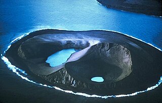
WBogoslof Island or Agasagook Island is the summit of a submarine stratovolcano at the south edge of the Bering Sea, 35 miles (56 km) northwest of Unalaska Island of the Aleutian Island chain. It has a land area of 319.3 acres (1.292 km2) and is uninhabited. The peak elevation of the island is 490 feet (150 m). It is 1,040 meters (3,410 ft) long and 1,512 m (4,961 ft) wide. The stratovolcano rises about 6,000 ft (1,800 m) from the seabed, but the summit is the only part that projects above sea level. The island is believed to be relatively new, with the volcano being entirely below sea level before 1796, and most of the presently 300 acre island being formed by eruptions since 1900.
 W
WBowie Seamount is a large submarine volcano in the northeastern Pacific Ocean, located 180 km (110 mi) west of Haida Gwaii, British Columbia, Canada.
 W
WThe Brothers Volcano is a Pacific Ocean submarine volcano in the Kermadec Arc, 340 kilometres north east of New Zealand's Whakaari/White Island. Within its oval outline, which measures 13 km by 8 km, it contains a 3 km wide caldera with walls 300-500 m high. It is three times bigger than the White Island. A dacite dome rises 350 m from the caldera floor, with a smaller dome just to its northeast.
 W
WDavidson Seamount is a seamount located off the coast of Central California, 80 mi (129 km) southwest of Monterey and 75 mi (121 km) west of San Simeon. At 26 mi (42 km) long and 8 mi (13 km) wide, it is one of the largest known seamounts in the world. From base to crest, the seamount is 7,480 ft (2,280 m) tall, yet its summit is still 4,101 ft (1,250 m) below the sea surface. The seamount is biologically diverse, with 237 species and 27 types of deep-sea coral having been identified.
 W
WDiscovery Seamounts are a chain of seamounts in the Southern Atlantic Ocean, which include the Discovery Seamount. The seamounts lie 850 kilometres (530 mi) east of Gough Island and once rose above sea level. Various volcanic rocks as well as glacial dropstones and sediments have been dredged from the seamounts.
 W
WEmpedocles is a large underwater volcano located 40 km off the southern coast of Sicily named after the Greek philosopher Empedocles who believed that everything on Earth was made up of the four elements.
 W
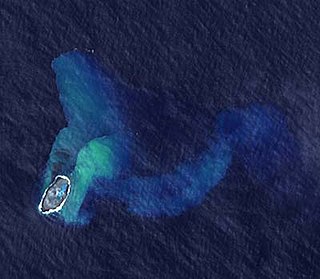
WEsmeralda Bank is a submarine volcano around 37 km west of Tinian Island of the Northern Mariana Islands in the Pacific Ocean. It is located at the southern end of the Mariana Arc. It has three summit cones lying along a north–south line. The highest peak is about 43 meters below the sea surface and has a caldera about 3 kilometers wide and several parasitic cones on the edge of the caldera. Sulfur boils and water discoloration have been observed at the site of the volcano, attributed to either eruptions or fumarolic activity.
 W
WFonuafo‘ou, formerly known as Falcon Island, is a submarine volcano in the western part of the Ha'apai group in Tonga. The volcano created an island several times throughout history.
 W
WFukutoku-Okanoba (福徳岡ノ場) is a submarine volcano that is part of the Volcano Islands in the Bonin Islands of Japan. It is located 5 kilometers northeast of the island of South Iwo Jima.
 W
WGraham Island was an island created by a now fully submerged volcano in the Mediterranean Sea. It was discovered when it last appeared on 1 August 1831 by Humphrey Fleming Senhouse, the captain of the first rate Royal Navy ship of the line St Vincent and named after Sir James Graham, the First Lord of the Admiralty. It was claimed by the United Kingdom. It forms part of the underwater volcano Empedocles, 30 km (19 mi) south of Sicily, and which is one of a number of submarine volcanoes known as the Campi Flegrei del Mar di Sicilia. Seamount eruptions have raised it above sea level several times before erosion submerged it again.
 W
WHanauma is a marine embayment formed within a tuff ring and located along the southeast coast of the Island of Oʻahu in the Hawaii Kai neighborhood of East Honolulu, in the Hawaiian Islands.
 W
WThe Hawaiian–Emperor seamount chain is a series of volcanoes and seamounts extending about 6,200 kilometres (3,900 mi) across the Pacific Ocean. The chain has been produced by the movement of the ocean crust over the Hawaiʻi hotspot, an upwelling of hot rock from the Earth's mantle. As the oceanic crust moves the volcanoes farther away from their source of magma, their eruptions become less frequent and less powerful until they eventually cease to erupt altogether. At that point, erosion of the volcano and subsidence of the seafloor cause the volcano to gradually diminish. As the volcano sinks and erodes, it first becomes an atoll island and then an atoll. Further subsidence causes the volcano to sink below the sea surface, becoming a seamount and/or a guyot. This list documents the most significant volcanoes in the chain, ordered by distance from the hotspot; however, there are many others that have yet to be properly studied.
 W
WHodgkins Seamount is a seamount in the Kodiak-Bowie Seamount chain, located south of Pierce Seamount and north of Bowie Seamount. It has apparently experienced two generically different episodes of volcanism, separated by about 12 million years. Like the rest of the Kodiak-Bowie seamounts, it was formed by the Bowie hotspot.
 W
WHome Reef is an ephemeral island built by a submarine volcano whose top has repeatedly broken the surface and afterwards was eroded away by wave action. It is in the South Pacific, south of Late Island and southwest of Vava'u along the Tofua volcanic arc in Tonga.
 W
WHunga Tonga-Hunga Haʻapai is a volcanic island located about 30 kilometres south-southeast of Fonuafoʻou island in Tonga. The volcano is part of the highly active Tonga-Kermadec Islands volcanic arc, a subduction zone extending from New Zealand north-northeast to Fiji. It lies about 100 kilometres (62 mi) above a very active seismic zone. The island arc is formed at the convergent boundary where the Pacific Plate subducts under the Indo-Australian Plate.
 W
WJólnir was formerly a volcanic island south of Iceland. It was a former vent of Surtsey, along with Syrtlingur and Surtla. It emerged from the ocean as a result of active plate tectonics between December, 1965 and July, 1966. Oceanic erosion cyclically wore down the new lava as it formed, and the island sank below the surface several times.
 W
WKavachi is one of the most active submarine volcanoes in the south-west Pacific Ocean. Located south of Vangunu Island in the Solomon Islands, it is named after a sea god of the New Georgia Group islanders, and is also referred to locally as Rejo te Kavachi. The volcano has become emergent and then been eroded back into the sea at least eight times since its first recorded eruption in 1939.
 W
WKick 'em Jenny is an active submarine volcano or seamount on the Caribbean Sea floor, located 8 km (5 mi) north of the island of Grenada and about 8 km (5 mi) west of Ronde Island in the Grenadines. Kick-'em-Jenny rises 1,300 m (4,265 ft) above the sea floor on the steep inner western slope of the Lesser Antilles ridge. The South American tectonic plate is subducting the Caribbean tectonic plate to the east of this ridge and under the Lesser Antilles island arc.
 W
WLōʻihi Seamount is an active submarine volcano about 35 km (22 mi) off the southeast coast of the island of Hawaii. The top of the seamount is about 975 m (3,000 ft) below sea level. This seamount is on the flank of Mauna Loa, the largest shield volcano on Earth. Lōʻihi, meaning "long" in Hawaiian, is the newest volcano in the Hawaiian–Emperor seamount chain, a string of volcanoes that stretches about 6,200 km (3,900 mi) northwest of Lōʻihi. Unlike most active volcanoes in the Pacific Ocean that make up the active plate margins on the Pacific Ring of Fire, Lōʻihi and the other volcanoes of the Hawaiian–Emperor seamount chain are hotspot volcanoes and formed well away from the nearest plate boundary. Volcanoes in the Hawaiian Islands arise from the Hawaii hotspot, and as the youngest volcano in the chain, Lōʻihi is the only Hawaiian volcano in the deep submarine preshield stage of development.
 W
WThe Moai Seamount is a submarine volcano, the second most westerly in the Easter Seamount Chain or Sala y Gómez ridge. It is east of Pukao seamount and west of Easter Island. It rises over 2,500 metres from the ocean floor to within a few hundred metres of the sea surface. The Moai seamount is fairly young, having developed in the last few hundred thousand years as the Nazca Plate floats over the Easter hotspot.
 W
WMusicians Seamounts are a chain of seamounts in the Pacific Ocean, north of the Hawaiian Ridge. There are about 65 seamounts, some of which are named after musicians. These seamounts exist in two chains, one of which has been attributed to a probably now-extinct hotspot called the Euterpe hotspot. Others may have formed in response to plate tectonics associated with the boundary between the Pacific Plate and the former Farallon Plate.
 W
WNW Rota-1 is a seamount in the Mariana Islands, northwest of Rota, which was discovered through its hydrothermal activity in 2003. The volcano has been observed to be erupting underwater, the first time that submarine explosive eruptions have been directly witnessed.
 W
WPatton Seamount is a prominent seamount in the Cobb–Eickelberg Seamount chain in the Gulf of Alaska. Located 166 nmi east of Kodiak Island and reaching to within 160 m (520 ft) of the ocean surface, Patton is one of the largest seamounts in the Cobb–Eickelberg Seamount chain. It was originally created near the coast of Oregon by the Cobb hotspot 33 million years ago, and was moved to its present location by tectonic plate movement. Patton is one of the most well-understood seamounts, as a major expedition using DSV Alvin in 1999 and another in 2002 helped define the scope of the seamount's biological community. Like other large seamounts, Patton acts as an ecological hub for sea life. Dives have revealed that the volcano is heavily encrusted in sea life of various forms, including sea stars, corals, king crabs, demersal rockfish, and other species.
 W
WSupply Reef is a submerged circular reef of volcanic origin in the Northern Mariana Islands chain, about 10 kilometres (6 mi) NW of the Maug Islands. Presently this igneous seamount is roughly 8 metres (26 ft) below the ocean's surface and about 100 m (300 ft) in diameter. Apparent episodes of submarine volcanism were noted on December 22-24 and 26-27 in 1989.
 W
WTamu Massif is an extinct submarine shield volcano in the northwest Pacific Ocean, with the characteristics of a hybrid between a mid-ocean ridge and a shield volcano. On 5 September 2013, researchers announced that it could be a single volcano which, if corroborated, would make Tamu Massif the largest known volcano on Earth. Tamu Massif is located in the Shatsky Rise about 1,600 km (990 mi) east of Japan. The volcano, which comprises the entire Shatsky Rise, covers an area of about 553,000 square kilometres (214,000 sq mi). Its summit is about 1,980 m (6,500 ft) below the surface of the ocean, and its base extends to about 6.4 km (4.0 mi) deep. The volcano is about 4,460 metres (14,620 ft) tall.
 W
WThe Tuzo Wilson Seamounts, also called J. Tuzo Wilson Knolls and Tuzo Wilson Knolls, are two young active submarine volcanoes off the coast of British Columbia, Canada, located 200 km (124 mi) northwest of Vancouver Island and south of the Haida Gwaii archipelago The two seamounts are members of the Kodiak-Bowie Seamount chain, rising 500 m (1,640 ft) to 700 m (2,297 ft) above the mean level of the northeastern Pacific Ocean and is a seismically active site southwest of the southern end of the Queen Charlotte Fault. They are named after Canadian geologist John Tuzo Wilson.
 W
WUnnamed volcano (Ibugos), is a submarine volcano near the island Ibugos in the Philippines.
 W
WVailuluʻu is a volcanic seamount discovered in 1975. It rises from the sea floor to a depth of 593 m (1,946 ft) and is located between Taʻu and Rose islands at the eastern end of the Samoa hotspot chain. The basaltic seamount is considered to mark the current location of the Samoa hotspot. The summit of Vailuluʻu contains a 2 km wide, 400 m deep oval-shaped caldera. Two principal rift zones extend east and west from the summit, parallel to the trend of the Samoan hotspot. A third less prominent rift extends southeast of the summit.
 W
WWest Mata is a submarine volcano at 1,100 meters depth 200 kilometres (120 mi) southwest of the Samoas. Its eruptions are currently the deepest observed.
 W
WYersey is a submarine volcano in Indonesia. It was listed as an active volcano in the old sea charts at the location in the southern of Banda Basin. During the 1929 survey, the volcano was spotted at the depth of 3,800 m along the ridge that stretches from Batu Tara until Gunungapi Wetar.