 W
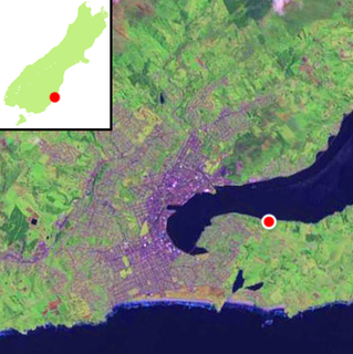
WThe Otago Peninsula is a long, hilly indented finger of land that forms the easternmost part of Dunedin, New Zealand. Volcanic in origin, it forms one wall of the eroded valley that now forms Otago Harbour. The peninsula lies south-east of Otago Harbour and runs parallel to the mainland for 20 km, with a maximum width of 9 km. It is joined to the mainland at the south-west end by a narrow isthmus about 1.5 km wide.
 W
WThe northern royal albatross or toroa, Diomedea sanfordi, is a large seabird from the albatross family. It was split from the closely related southern royal albatross as recently as 1998, though not all scientists support that conclusion and some consider both of them to be subspecies of the royal albatross.
 W
WThe southern royal albatross is a large seabird from the albatross family. At an average wingspan of above 3 m (9.8 ft), it is one of the two largest species of albatross, together with the wandering albatross. Recent studies indicate that the southern royal albatross may, on average, be somewhat larger than the wandering albatross in mass and have a similar wingspan, although other sources indicate roughly similar size for the two species and the wandering species may have a larger average wingspan in some colonies.
 W
WAllans Beach is a white sand beach on the Pacific Ocean coast of Otago Peninsula, in the South Island of New Zealand. It forms the seaward shore of a large spit at the entrance to Hoopers Inlet. Allans Beach is 25 kilometres (16 mi) by road from Dunedin city centre and 6 kilometres (3.7 mi) from the small town of Portobello. It receives little human traffic but is known to trampers, surfers, and naturists.
 W
WAndersons Bay is a suburb of the New Zealand city of Dunedin. It is located in the southeast of the city's urban area, 2.8 kilometres (1.7 mi) southeast of the city's centre.
 W
WBoulder Beach is a rocky beach which is located on the Pacific (southeast) side of the Otago Peninsula, New Zealand. Boulder Beach can be accessed by a number of walking tracks. These tracks begin at Braidwood Road, Paradise Road, Buskin Road, Seal Point Road, and Karetai Road. All these tracks are linked and create the Bolder Beach walking track system. The beach is located west of Sandfly Bay which is easier to access. Unlike Sandfly Bay Boulder Beach is very rocky with only one section which is composed of sand.
 W
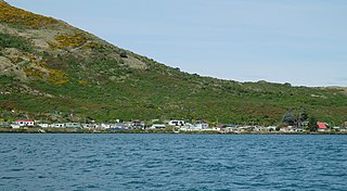
WThe settlement of Broad Bay is located on the Otago Harbour coast of Otago Peninsula, in the South Island of New Zealand. It is administered as part of the city of Dunedin, and is technically a suburb of that city, though its isolation and semi-rural nature make it appear as a settlement in its own right.
 W
WChallis is a settlement on the Otago Harbour coast of Otago Peninsula, within the city limits of the New Zealand city of Dunedin. Though officially regarded as a suburb, the isolated nature of Challis means that most locals regard it as a separate settlement within the city limits.
 W
WFletcher House is a historic house at Broad Bay on Otago Peninsula, part of the New Zealand city of Dunedin. The house was one of the first to be built by Sir James Fletcher, the founder of one of New Zealand's biggest companies, Fletcher Construction. The house is located at 727 Portobello Road, Broad Bay, on a promontory overlooking nearby Turnbulls Bay. The property is managed by the Otago Peninsula Trust, with the help of financial support from the Fletcher Trust. It is the only fully restored and furnished Edwardian house of its type in New Zealand.
 W
WThe settlement of Harington Point lies within the boundaries of the city of Dunedin, New Zealand. It is located at the Otago Heads, at the northeastern end of Otago Peninsula, close to the entrance of Otago Harbour. The mouth of the harbour is at its narrowest at Harington Point, only some 400 metres separating the point from the mudflats at Aramoana on the opposing coast.
 W
WHoopers Inlet is one of two large inlets in the Pacific coast of Otago Peninsula, in the South Island of New Zealand.
 W
WLarnach Castle is a mock castle on the ridge of the Otago Peninsula within the limits of the city of Dunedin, New Zealand, close to the small settlement of Pukehiki. It is one of a few houses of this scale in New Zealand. The house was built by the prominent entrepreneur and politician, William Larnach. Since 1967, the castle has been privately owned by the Barker family, and opened as a tourist attraction, as "New Zealand's only castle".
 W
WMacandrew Bay is located on the Otago Peninsula in the South Island of New Zealand. It is situated on the edge of Otago Harbour, and is named for pioneer European settler James Macandrew who lived here during his later life. The Te Reo Māori name for the bay, Te Roto Pāteke, refers to the Brown teal formerly prevalent in the area. Early European residents of the area called the bay "The Hundreds", due to the large number of boulders which covered the foreshore.
 W
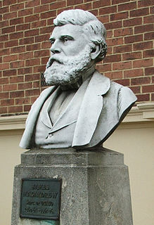
WJames Macandrew was a New Zealand ship-owner and politician. He served as a Member of Parliament from 1853 to 1887 and as the last Superintendent of Otago Province.
 W
WOcean Grove, also known as Tomahawk and Toma haka in Te Reo Maori, is a suburb in the southeast of the New Zealand city of Dunedin. A semi-rural residential suburb on the Pacific coast at the southwestern end of the Otago Peninsula, Ocean Grove is located 6.5 kilometres (4.0 mi) southeast of Dunedin city centre.
 W
WOtago Harbour is the natural harbour of Dunedin, New Zealand, consisting of a long, much-indented stretch of generally navigable water separating the Otago Peninsula from the mainland. They join at its southwest end, 21 km (13 mi) from the harbour mouth. It is home to Dunedin's two port facilities, Port Chalmers and at Dunedin's wharf. The harbour has been of significant economic importance for approximately 700 years, as a sheltered harbor and fishery, then deep water port.
 W
WThe Otago Heads is the historic name given to the headlands and coastal settlements close to the mouth of the long drowned volcanic rift which forms the Otago Harbour, in the South Island of New Zealand.
 W
WOtakou is a settlement within the boundaries of the city of Dunedin, New Zealand. It is located 25 kilometres from the city centre at the eastern end of Otago Peninsula, close to the entrance of Otago Harbour. Though a small fishing village, Otakou is important in the history of Otago for several reasons. The settlement is the modern centre and traditional home of the Ōtākou rūnanga (assembly) of Ngāi Tahu. In 1946 Otakou Fisheries was founded in the township; this was later to become a major part of the Otago fishing industry.
WPapanui Inlet is the northernmost of two large inlets in the Pacific coast of Otago Peninsula, in the South Island of New Zealand.
 W
WThe yellow-eyed penguin, known also as hoiho or tarakaka, is a species of penguin endemic to New Zealand.
 W
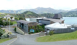
WThe Portobello Marine Laboratory is located on the end of a short peninsula close to the township of Portobello, within the limits of the city of Dunedin in New Zealand's South Island. It is run as part of the University of Otago, the main campus of which is 23 kilometres to the southwest in Dunedin's main urban area.
 W
WPortobello School is a New Zealand primary school located on Harington Point Road, Portobello, on the Otago Peninsula.
 W
WPortobello is a village beside the Otago Harbour halfway along the Otago Peninsula in Dunedin City, New Zealand. It lies at the foot of a small peninsula between Portobello Bay and Latham Bay.
 W
WPukehiki is a small locality on Otago Peninsula, within the city of Dunedin in the South Island of New Zealand. It is located on the ridge which runs along the centre of the peninsula, 8 kilometres (5.0 mi) from Dunedin city centre, at a junction between Highcliff Road, which runs along the peninsula's ridge, and Castlewood Road, which descends to Company Bay on the shore of the Otago Harbour.
 W
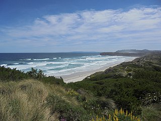
WSandfly Bay is a sandy bay with large dunes 15 kilometres (9.3 mi) east of central Dunedin, New Zealand. Located on the southern side of Otago Peninsula, between Seal Point and the Gull Rocks on the western side of Sandymount, Sandfly Bay is a Department of Conservation wildlife reserve frequented by trampers.
 W
WKaimata, or Cape Saunders, is the prominent headland on the Pacific Ocean coast of Muaupoko, the Otago Peninsula, in the far south-east of Aotearoa New Zealand's Te Wai Pounamu, the South Island. It is home to the Cape Saunders Lighthouse.
 W
WShiel Hill is a residential suburb of the New Zealand city of Dunedin. It is located at the southeastern edge of the city's urban area, 3.2 kilometres (2.0 mi) southeast of the city's centre at the western end of the Otago Peninsula, close to the isthmus joining the peninsula to the mainland. As the name suggests, it is situated on the slopes of a hill at the start of the ridge which runs along the spine of the peninsula. The slopes rise to a series of crests generally known collectively as Highcliff, a name also often applied to the last suburban vestiges which remain as Dunedin's urban area becomes the rural land of the peninsula. More accurately, the name is that of a cliff which lies on the Pacific coast of the peninsula 4 kilometres (2.5 mi) east of Shiel Hill.
 W
WSmaills Beach is a beach on the Pacific Ocean 7.6 kilometres (4.7 mi) southeast of the city centre of Dunedin, New Zealand. Located within the Ocean Grove Reserve adjacent to Tomahawk Beach, at the point where Otago Peninsula joins the mainland of the South Island, Smaills Beach is a white sand beach for much of its length, but its western end is covered in volcanic boulders. Just offshore from the beach, dominating the wave patterns of the surf, is the rocky outcrop known as Bird Island. Smaills Beach is renowned for its wildlife and popular with surfers.
 W
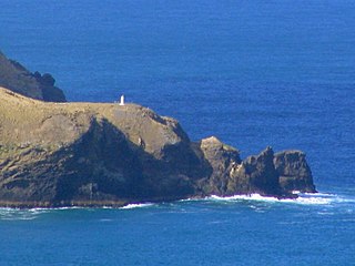
WTaiaroa Head is a headland at the end of the Otago Peninsula in New Zealand, overlooking the mouth of the Otago Harbour. It lies within the city limits of Dunedin. The nearest settlement, Otakou, lies three kilometres to the south.
 W
WTomahawk Beach is a beach on the Pacific Ocean 7.5 kilometres (4.7 mi) southeast of the city centre of Dunedin, New Zealand. Located within the Ocean Grove Reserve between St Kilda Beach and Smaills Beach, at the point where Otago Peninsula joins the mainland of the South Island, Tomahawk Beach is a white sand beach popular with casual beach-goers and dog-walkers as well as surfers. Sand is extracted from the Tomahawk Lagoon channel, which runs across the beach, for commercial purposes and to prevent flooding.
 W
WTomahawk Lagoon is a twin-lobed lagoon, located at the western end of the Otago Peninsula within the city limits of Dunedin, New Zealand. It lies close to the southeastern edge of the city's main urban area, near the suburb of Ocean Grove, which lies close to its southern shore. This suburb was also known as Tomahawk until the 1930s.
 W
WVictory Beach is located on the Pacific Ocean coast of the Otago Peninsula, in the South Island of New Zealand, 24 kilometres (15 mi) by road from Dunedin city centre and 7 kilometres (4.3 mi) from the nearby town of Portobello. The longest beach on the peninsula, Victory Beach is located northeast of the entrance to Papanui Inlet and stretches for 3.2 kilometres (2.0 mi). The beach's name derives from the wreck of the SS Victory on the beach in 1861.
 W
WWaverley is a suburb of the New Zealand city of Dunedin. It was named after Sir Walter Scott's novel Waverley, first novel in a series known as the Waverley Novels, among the most popular and widely read English-language novels of the 19th century. Waverley is located at the start of the Otago Peninsula, 2.4 kilometres (1.5 mi) southeast of the city centre, on a rise overlooking the Otago Harbour to the north.