 W
WLake Tahoe is located in the Sierra Nevada of both California and Nevada. A list of notable mountains that surround the lake is shown below.
 W
WBald Rock is a granite batholith located in Butte County, California, in the Plumas National Forest. Located close to Lake Oroville, the dome peak overlooks Sacramento Valley and coastal mountain ranges.
 W
WBrown Peak is a peak located in Kern County, California. The peak is located on King Solomons Ridge at the head of Haight Canyon, 2.1 miles (3.4 km) southwest of Liebel Peak and 12.5 miles (20 km) north of Loraine, California in Sequoia National Forest.
 W
WCastle Peak is a mountain in California's Sierra Nevada near I-80, Donner Pass, and the Nevada border. It is in the Tahoe National Forest not far off the Pacific Crest Trail, and adjacent to Castle Pass. It was originally named Mount Stanford by the Whitney Survey of 1860–74.
 W
WDardanelles Cone is a mountain peak in the Carson-Iceberg Wilderness on the Stanislaus National Forest. It lies near Sonora Pass in the Sierra Nevada of California. It is between State Route 4 and State Route 108.
 W
WDunderberg Peak is located east of the Sierra Nevada crest near the divide between the Mono Basin and East Walker River basin in Mono County, in eastern California in the southwestern United States. The peak is in the Hoover Wilderness and is the highest point in Humboldt-Toiyabe National Forest.
WMount Fillmore is a mountain in the Plumas National Forest in Sierra County, California. It is 8 miles (13 km) northeast of La Porte and 12 miles (19 km) north of Downieville.
 W
WFreel Peak is a mountain located in the Carson Range, a spur of the Sierra Nevada, near Lake Tahoe in California.
 W
WFresno Dome is a dominant granite dome rising in isolation above the forest of Soquel Meadow in the Sierra National Forest in Madera County, California.
WMount Goethe is a summit in Fresno County, California, in the United States. With an elevation of 13,270 feet (4,045 m), Mount Goethe is the 96th highest summit in the state of California.
 W
WGranite Chief is a mountain located in the Sierra Nevada near Lake Tahoe. The mountain rises to an elevation of 9,010 feet (2,746 m) and receives consistent heavy snowfall during the winter months.
WMount Ina Coolbrith is a mountain of the Sierra Nevada, near the Nevada border in Sierra County, Northern California.
WMount Ingalls is a mountain located in the Northern Sierra Nevada in California. The peak rises to an elevation of 8,376 feet (2,553 m), and is the highest point in Plumas County and Plumas National Forest. Most of the precipitation that falls on the mountain is snow due to the high elevation.
 W
WJobs Peak located in Alpine County, California, is the most prominent peak visible from the Carson Valley in Douglas County, Nevada. The peak offers hiking and backcountry skiing with the view of Lake Tahoe. It is in the Humboldt-Toiyabe National Forest.
WKern Peak is a mountain peak in Tulare County, California in the Sierra Nevadas. At 11,510 ft (3,508 m) in elevation and about 2,560 ft (780 m) of prominence, it is ranked 49th on the most prominent peaks in California. It is west of Olancha Peak, which is in the same mountain range. The climb to the top of this summit follows a paved road, and the trail is about 28 mi (45 km) long. The best time to climb the mountain is May to October.
 W
WLeavitt Peak is located in the Emigrant Wilderness near Sonora Pass in the eastern Sierra Nevada range of California. Leavitt Peak is located on the Tuolumne County - Mono County line. The Pacific Crest Trail runs close to the east of Leavitt Peak, at an elevation of about 10,800 feet (3,290 m) elevation. The peak offers views south to Yosemite National Park and north towards South Lake Tahoe.
WMount Lola is a mountain in the Sierra Nevada of California. Its summit, located north of Donner Pass and Interstate 80, is the highest point in Nevada County. It is also the highest point in the Sierra Nevada north of Interstate 80. A subsidiary peak 1.2 miles (1.9 km) north of the main summit is highest point in Sierra County at 8,848 feet (2,697 m) NAVD 88.
 W
WLone Pine Peak is located on the east side of the Sierra Nevada range just west of the town of Lone Pine, California in Inyo County, in eastern California in the southwestern United States. The summit marks the eastern boundary of the John Muir Wilderness in the Inyo National Forest. Lone Pine Peak is the mountain in the photo for the default desktop of macOS Sierra.
 W
WMammoth Mountain is a lava dome complex patially located within the town of Mammoth Lakes, California, in the Inyo National Forest of Madera and Mono Counties. It is home to a large ski area primarily on the Mono County side.
 W
WNorth Peak is an alpine peak just north of Mount Conness in the Sierra Nevada. The summit is to the west of the Hall Natural Area and on the boundary between the Inyo National Forest and Yosemite National Park. North Peak is in Tuolumne County in eastern California in the southwestern United States.
 W
WOlancha Peak is a mountain in the Sierra Nevada of California. It rises to an elevation of 12,132 feet (3,698 m) on the Tulare-Inyo county line in the South Sierra Wilderness. It takes its name from the nearby town of Olancha.
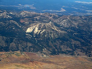
WRed Lake Peak is believed to be the vantage point from which John C. Fremont and Charles Preuss made the first recorded sighting of Lake Tahoe by Europeans in February 1844 as Fremont's exploratory expedition made a desperate crossing of the Sierra Nevada through what is now Carson Pass on their way to obtain provisions at Sutter's Fort. The peak lies just north of the pass and generally northwest of the small lake east of the pass for which the peak is named. Lake Tahoe is visible to the north from the peak.
 W
WSan Joaquin Mountain is a mountain along the Sierra Crest, near June Lake, California. It is the twenty-sixth highest peak in California, and is the highest peak along the Sierra Crest for 25 miles (40 km). The mountain is formed of quartz latite that erupted during the Pliocene.
 W
WSchroeder Mountain is a mountain in the California's Sierra Nevada, on the Tahoe National Forest. It is located 0.8 miles (1 km) east of California State Route 49 in Sierra County. Its elevation is 6,942 feet (2,116 m).
WSentinel Peak is located near Johnsondale, California. It is a popular with Boy Scouts visiting Camp Whitsett, with several hundred scouts hiking the mountain each week in the summer. It is in Giant Sequoia National Monument and Sequoia National Forest.
 W
WTahoe National Forest is a United States National Forest located in California, northwest of Lake Tahoe. It includes the 8,587-foot (2,617 m) peak of Sierra Buttes, near Sierra City, which has views of Mount Lassen and Mount Shasta. It is located in parts of six counties: Sierra, Placer, Nevada, Yuba, Plumas and El Dorado. The forest has a total area of 871,495 acres. Its headquarters is in Nevada City, California. There are local ranger district offices in Camptonville, Foresthill, Sierraville and Truckee.
WSirretta Peak is a mountain located in the southern Sierra Nevada in California. It rises to an elevation of 9,982 feet (3,043 m) north of Highway 178 and Lake Isabella. The high elevation means that most of the precipitation the mountain receives is snow.
 W
WSlide Mountain is a 9,702-foot (2,957 m) peak in the Carson Range near Reno, in Washoe County, Nevada. From the summit of Slide Mountain, Lake Tahoe, Washoe Lake, Carson Valley, and the city of Reno can be viewed.
 W
WMount Solomons is a peak in the Sierra Nevada mountain range in the U.S. state of California. It rises to 13,040 feet (3,975 m) directly above Muir Pass. Mount Solomons was named after Theodore Solomons, an explorer of the Sierra Nevada mountains, who mapped and established what is now the northern half of John Muir Trail.
 W
WSonora Peak is a mountain in the Central Sierra Nevada of California north of Sonora Pass. Located on the boundary between Alpine and Mono counties, it is the highest point in Alpine County. Due to the high elevation, most of the precipitation this mountain receives consists of snow.
WSugar Pine Peak is a mountain located in the northern Northern Sierra Nevada, in the Plumas National Forest in California.
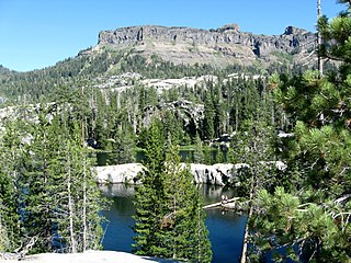
WTable Mountain is a mountainous landscape feature in Tuolumne County, California near the town of Jamestown. Table Mountain is an inverted valley, an elevated landform which follows the former contours of a river valley above level of the surrounding topography, rather than below it. It was created by lava flows which filled an ancient river bed. The resulting igneous rock resisted erosion better than the materials around it, leaving behind a sinuous rock formation elevated above the surrounding landscape.
 W
WThunder Mountain in the Sierra Nevada of California is located east of Silver Lake and west of Kirkwood Mountain Resort in the Eldorado National Forest. The mountain has two peaks, the 9,414-foot (2,869 m) main peak and a 9,412-foot (2,869 m) sub-peak west of the main peak. The main summit is the highest point in Amador County. Due to the high elevation, most precipitation that falls on Thunder Mountain consists of snow.