 W
WKarst is a topography formed from the dissolution of soluble rocks such as limestone, dolomite, and gypsum. It is characterized by underground drainage systems with sinkholes and caves. It has also been documented for more weathering-resistant rocks, such as quartzite, given the right conditions. Subterranean drainage may limit surface water, with few to no rivers or lakes. However, in regions where the dissolved bedrock is covered or confined by one or more superimposed non-soluble rock strata, distinctive karst features may occur only at subsurface levels and can be totally missing above ground.
WKarst is a topography formed from the dissolution of soluble rocks such as limestone, dolomite, and gypsum. It is characterized by underground drainage systems with sinkholes and caves. It has also been documented for more weathering-resistant rocks, such as quartzite, given the right conditions. Subterranean drainage may limit surface water, with few to no rivers or lakes. However, in regions where the dissolved bedrock is covered or confined by one or more superimposed non-soluble rock strata, distinctive karst features may occur only at subsurface levels and can be totally missing above ground.
 W
WThe Blatnica Valley is a karst valley in the Greater Fatra Range in Slovakia. It is accessible from the village of Blatnica along a dirt road. Most of the valley is densely forested, in places with views at the surrounding limestone and dolomite strata. The best known part of the valley is the rock window at its lower part. Ostrá and Drieňok mountains can be climbed from the valley bottom.
 W
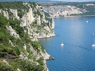
WA calanque is a narrow, steep-walled inlet that is developed in limestone, dolomite, or other carbonate strata and found along the Mediterranean coast. A calanque is a steep-sided valley formed within karstic regions either by fluvial erosion or the collapse of the roof of a cave that has been subsequently partially submerged by a rise in sea level.
 W
WCansiglio is a plateau in the northern-Italian Prealps, included in the provinces of Belluno, Treviso and Pordenone. Cansiglio is home to a very small Language island of Cimbrian.
 W
WA foiba — jama in South Slavic languages scientific and colloquial vocabulary — is a type of deep natural sinkhole, doline, or sink, and is a collapsed portion of bedrock above a void. Sinks may be a sheer vertical opening into a cave, or a shallow depression of many hectares. They are common in the Karst (Carso) region shared by Italy and Slovenia, as well as in a karst of Dinaric Alps in Bosnia and Herzegovina, Montenegro and Croatia.
 W
WGlaciokarst is a karst landscape that was glaciated during the cold periods of the Pleistocene and displays major landforms of glacial influence. For this reason karstification can be pre- and/or post- Pleistocene; this is not easy to classifiy. Mostly Glaciokarst has not such distinctly karst landforms.
 W
WGurio Lamanna is a doline shaped like a coat of arms located in the Murge plateau and falling into Gravina in Puglia's territory, on the border with Altamura, Apulia, southern Italy. It is "one of the largest karst landforms of the Murge plateau" and it is located very close to other two dolines, namely Pulicchio di Gravina and Tre Paduli. Depending on the type of geomorphologic classification employed and the author who suggested it, the karst landform can be defined either a doline or a "karst basin". It is traditionally called "karst basin", following the suggestion of Carmelo Colamonico, who first studied the doline and saw in its large size and shallow depth a good reason to distinguish it from a normal doline. The definition of "karst basin", used by Carmelo Colamonico, has been introduced by Renato Biasutti. Carmelo Colamonico stated that Gurio Lamanna is "one of the best examples of karst basin in the Murge plateau".
 W
WKaragiye is a 40 kilometres (25 mi) long karst trench close to the Caspian Sea. At its lowest point at Vpadina Kaundy, it is approximately 132 metres (433 ft) below sea level. It is the lowest point in Central Asia, Kazakhstan, and the former Soviet Union. It is also known as the Karagiye Depression and Karagiye Mountain Trench.
 W
WThe Karst Living Museum is a nature trail in Slovenia. Part of the Karst Plateau, the museum is an ecologically-important area with many karst features. It was recognized as Slovenia's best thematic trail in 2017, and the region is a Natura 2000 site.
 W
WThe Karst Plateau or the Karst region, also locally called Karst, is a karst plateau region extending across the border of southwestern Slovenia and northeastern Italy.
 W
WA karst spring or karstic spring is a spring that is part of a karst hydrological system.
Karst Underwater Research (KUR) is a registered 501(c)(3) non-profit organization that specializes in the research and documentation of karst aquifers and their corresponding surface features. KUR members perform a variety of scientific processes, including mapping and cartography, radio location, photography, videography, YSI water analysis and sampling.
 W
WKefalari Greek:Κεφαλάρι ‚spring‘ ) is the name of the community Kefalari (Argolis). Several Greek villages in mountainous areas, where spring water is abundant, have similar names with some kind of describing supplements. This article is about the community at the northern boarder of the “Plain of Argos”, Peloponnese, at the Argolic Gulf. The village developed around a large geologically significant karst spring. In the mythology and the life of ancient Greeks this spring was of importance and today it is a place of orthodox pilgrimage.
 W
WThe Kräuterin is a karst massif with a size of 10 km by 12 km, located in the Ybbstal Alps, Austria. Its highest peak is the Hochstadl, at 1919 meters above sea level.
 W
WA limestone pavement is a natural karst landform consisting of a flat, incised surface of exposed limestone that resembles an artificial pavement. The term is mainly used in the UK and Ireland, where many of these landforms have developed distinctive surface patterning resembling paving blocks. Similar landforms in other parts of the world are known as alvars.
 W
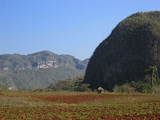
WA mogote is a generally-isolated steep-sided residual hill composed of either limestone, marble, or dolomite. Mogotes are surrounded by nearly flat alluvial plains. The hills typically have a rounded, tower-like form. Several mogotes along a ridge are called pepinos.
 W
WThe Moravian Karst is a karst landscape and protected nature reserve to the north of Brno in the eastern part of the Czech Republic, located near the town of Blansko. It encompasses a number of notable geological features, including roughly 1100 caverns and gorges and covers an area of roughly 92 km². Currently, five of the cave systems, Býčí skála Cave (closed) and Stránská skála are open for public tours and exploration.
 W
WŌike (大池) is a karst pond on Minamidaitōjima, Okinawa Prefecture, Japan. Ōike is the largest pond containing both freshwater and seawater. It covers 0.31 square kilometres (0.12 sq mi), the circumference is 5.50 kilometres (3.42 mi), and it is 1.3 metres at its deepest point. Fresh water is mixed with seawater beneath.
 W
WA pit cave, shaft cave or vertical cave—or often simply called a pit or pot ; jama in South Slavic languages scientific and colloquial vocabulary —is a type of cave which contains one or more significant vertical shafts rather than being predominantly a conventional horizontal cave passage. Pit caves typically form in limestone as a result of long-term erosion by water. They can be open to the surface or found deep within horizontal caves. Among cavers, a pit is a vertical drop of any depth that cannot be negotiated safely without the use of ropes or ladders.
 W
WPulicchio di Gravina is the second-largest doline in the Murge plateau after Pulo di Altamura. It falls into the territory of Gravina in Puglia, being located about 10 kilometers (6.2 mi) north of the latter, close to the border with Altamura's territory. It shares the local toponym pulo with other large dolines of the region, i.e. Pulo di Altamura, Pulo di Molfetta and Pulicchio di Toritto.
 W
WPulo di Altamura is a doline located on the Murge plateau. It is the largest doline in that region and it is located about 6 kilometers (3.7 mi) north-west of the city of Altamura. It shares the local toponym pulo with other large dolines of the region, i.e. Pulicchio di Gravina, Pulo di Molfetta and Pulicchio di Toritto.
 W
WPulo di Molfetta is a doline located on the Murge plateau, in Apulia, southern Italy, around 1.5 kilometers (0.93 mi) south-west of the city of Molfetta. It originated due to the collapse of the ceiling of one or more caves. It shares the local toponym pulo with other large dolines of the region, i.e. Pulicchio di Gravina, Pulo di Molfetta and Pulicchio di Toritto.
 W
WThe Sierra de Tamaulipas is an isolated, semi-tropical mountain range in the Mexican state of Tamaulipas. Its highest point is 1,260 m (4,130 ft). There are no cities or towns in the Sierra and the small population is largely agricultural. The higher elevations of the Sierra have forests of oak and pine, contrasting with the semi-arid brush that dominates at lower altitudes. Several archaeological sites establish that the Sierra de Tamaulipas was the northern outpost of the agricultural Mesoamerican peoples of eastern Mexico.
 W
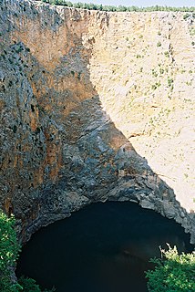
WA sinkhole, also known as a cenote, sink, sink-hole, swallet, swallow hole, or doline, is a depression or hole in the ground caused by some form of collapse of the surface layer. Most are caused by karst processes – the chemical dissolution of carbonate rocks or suffosion processes. Sinkholes vary in size from 1 to 600 m both in diameter and depth, and vary in form from soil-lined bowls to bedrock-edged chasms. Sinkholes may form gradually or suddenly, and are found worldwide.
 W
WSlovak Karst National Park is a national park in the Slovak Karst mountain range in South East Slovakia. It lies in the Gelnica, Rožňava and Košice–okolie districts in the Košice region. The National Park covers an area of 346.11 km² (133.64 mi²) and its buffer zone covers 117.41 km² (45.33 mi²).
 W
WSpeleothems, commonly known as cave formations, are secondary mineral deposits formed in a cave. Speleothems typically form in limestone or dolomite solutional caves. The term "speleothem," as first introduced by Moore (1952), is derived from the Greek words spēlaion "cave" + théma "deposit". The definition of "speleothem," in most publications, specifically excludes secondary mineral deposits in mines, tunnels, and other man-made structures. Hill and Forti more concisely defined "secondary minerals" which create speleothems in caves:A "secondary" mineral is one which is derived by a physicochemical reaction from a primary mineral in bedrock or detritus, and/or deposited because of a unique set of conditions in a cave; i.e., the cave environment has influenced the mineral's deposition.
 W
WA subterranean river is a river that runs wholly or partly beneath the ground surface – one where the riverbed does not represent the surface of the Earth. It is distinct from an aquifer, which may flow like a river but is contained within a permeable layer of rock or other unconsolidated materials. A river flowing below ground level in an open gorge is not classed as subterranean.
 W
WSuffosion is one of the two geological processes by which subsidence sinkholes or dolines are formed, the other being due to collapse of an underlying cave or void, with most sinkholes formed by the suffosion process. Suffosion sinkholes are normally associated with karst topography although they may form in other types of rock including chalk, gypsum and basalt. In the karst of the UK's Yorkshire Dales, numerous surface depressions known locally as "shakeholes" are the result of glacial till washing into fissures in the underlying limestone.
WAn underground lake or subterranean lake is a lake under the surface of the Earth. Such lakes may be associated with caves, aquifers, or springs. They are typically very low in salinity.
 W
WThe water table is the upper surface of the zone of saturation. The zone of saturation is where the pores and fractures of the ground are saturated with water.
 W
WWeymer Creek Provincial Park, formerly Weymer Creek Karst Provincial Park, is a provincial park located on the west coast of Vancouver Island in British Columbia, Canada, just southeast of the community of Tahsis in the region of Nootka Sound. Its most important feature is its karst topography and some of the deepest caves in Canada. Caving is currently not permitted in the park and visitors to the area are requested to practice "no trace" camping.
 W
WYana is a village located in forests of the Kumta, Uttara Kannada district of Karnataka, India which is known for the unusual karst rock formations. It is located in the Sahyadri mountain range of the Western Ghats, about 60 kilometres (37 mi) from Karwar port, 40 kilometres (25 mi) from Sirsi, and 31 kilometres (19 mi) from Kumta. Yana is one of the wettest villages in the world and it is cleanest village in Karnataka and second cleanest village in India. The two unique rock outcrops near the village are a tourist attraction and easily approachable by a small trek through 0.5 kilometres (0.31 mi) of thick forests from the nearest road head.