 W
WIstria, formerly Histria (Latin), Ίστρια, is the largest peninsula in the Adriatic Sea. The peninsula is located at the head of the Adriatic between the Gulf of Trieste and the Kvarner Gulf. It is shared by three countries: Croatia, Slovenia, and Italy. Croatia encapsulates most of the Istrian peninsula with its Istria County.
 W
WThe A8 motorway is a 64.0-kilometre (39.8 mi) toll motorway in Croatia. It connects the A7 motorway near Rijeka with the road network in the Istrian peninsula via the Učka Tunnel. The road terminates at the Kanfanar interchange with the A9 motorway, which with the A8 motorway forms the Istrian Y road system. The motorway's national significance is reflected in its positive economic impact on the cities and towns it connects, as well as its importance to tourism in Croatia. The importance of the motorway for tourism is particularly high during the summer tourist season, when its traffic volume increases by about 65%.
 W
WAnkaran is a town in the Municipality of Ankaran, located near the border with Italy, in the Littoral region of Slovenia. It is less than 5 km from the Italian town of Muggia near Trieste, about 2.5 km from the Italian-Slovenian border, 6.5 km from Koper, and 33 km from the nearest Croatian town, Buje. In the entire municipality both Slovenian and Italian are official languages.
 W
WBelaj is a small village and Baroque Castle in Istria County, Croatia, in the municipality of Cerovlje. Castle Belaj is a registered Historical Heritage. Castle Belaj historically has numerous hectares of vineyard. In 2017 Belaj Castle opens to the public. In 2011, the population of the village is 16. In the vicinity of the village is another castle Posert.
 W
WThe Dragonja is a 30-kilometre (19 mi) long river in the northern part of the Istrian peninsula. It is a meandering river with a very branched basin and a small quantity of water. It has the pluvial regime and often dries up in summer. It features very diverse living environments and is home to a number of animal and plant species. The Dragonja has been a matter of a territorial dispute between Croatia and Slovenia, with its lowest portion de facto the border of the two countries.
 W
WThe European route E751, or E751, as defined by the Declaration on the Construction of Main International Traffic Arteries of 1975, and subsequent documents which amended the treaty, is an east-west Class-B branching European road route. Originating in Rijeka, Croatia, where it diverges from European route E61 before passing through the Kanfanar interchange, the route connects Pula, Rovinj, Poreč and Umag in Croatia with Koper in Slovenia. The route provides a high-performance road link in Istria and Slovenian Littoral. Unlike most routes, the E751 centers on the Kanfanar interchange and has three arms, each extending to Rijeka, Pula and Koper. The total length of the route, including all the route arms, is 160 km (99 mi).
 W
WThe Gulf of Venice is a gulf that borders modern-day Italy, Slovenia and Croatia, and is at the north of the Adriatic Sea between the delta of the Po river in Northern Italy and the Istria peninsula in Croatia.
 W
WThe Kingdom of Illyria was a crown land of the Austrian Empire from 1816 to 1849, the successor state of the Napoleonic Illyrian Provinces, reconquered by Austria in the War of the Sixth Coalition and restored according to the Final Act of the Vienna Congress. Its administrative centre was in Ljubljana
 W
WThe Istarski mih or Istrian mih is a bagpipe native to the regions of Istria and Kvarner, Croatia.
 W
WIstria County is the westernmost county of Croatia which includes the biggest part of the Istrian peninsula.
 W
WIstrian Italians are an ethnic group from the Adriatic region of Istria in modern northwestern Croatia. Istrian Italians descend from the original Latinized population of Roman Histria, from the Venetian-speaking settlers who settled in the region during the time of the Republic of Venice, and from the South Slavic population, Croats, who culturally assimilated.
 W
W"Istrian scale" refers both to a "unique" musical scale of folk music genres from Istria and Kvarner which use the style. It is named for the Istrian peninsula. Istrian folk music is based on a distinctive six-tone musical scale, and the peninsula's two-part, slightly nasal singing. The two-part singing and playing in the Istrian scale, a traditional singing practice characteristic of the Istrian region and the north Adriatic coastal area and islands, was inscribed in UNESCO's List of Intangible Cultural Heritage in 2009.}}
 W
WThe Italian irredentism in Istria was the political movement supporting the unification to Italy, during the 19th and 20th centuries, of the peninsula of Istria. It is considered closely related to the Italian irredentism in Trieste and Fiume, two cities bordering the peninsula.
 W
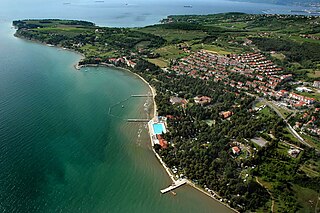
WIzola is an old fishing town in southwestern Slovenia on the Adriatic coast of the Istrian peninsula. It is the seat of the Municipality of Izola. Its name originates from Italian Isola, which means 'island'.
 W
WThe Koper Regional Museum has been housed since 1954 in the spacious early 17th century Belgramoni Tacco Palace, and is responsible for the movable cultural heritage in Primorska region of Slovenia. The museum originated in 1911 as the Municipal Museum of History and Art. At its centenary in 2011, the museum opened a new permanent exhibition Between the Serenissima, Napoleon and the Habsburgs and enriched its collection.
 W
WLyrics of the song "Krasna zemljo" were written by Ivan Cukon in 1912, and the music was composed by Matko Brajša Rašan. The song was written as the Hymn of the Company Saints Cyril and Methodius and later became an unofficial anthem of the region of Istria.
 W
WLake Čepić was the only natural lake in Istria, Croatia. It was drained in 1932 with a 4,250 m long tunnel near Plomin to the sea. The surface of the vast green valley was transformed into a fertile field for agriculture. The field's area is around 7 km2, and the Boljunčica River flows into it, while from it Raša River.
 W
WMonkodonja is a hill fort occupied about 1800–1200 BC during the Bronze Age, located near the city of Rovinj in the Croatian region of Istria.
 W
WOpatija is a town in Primorje-Gorski Kotar County in western Croatia. The traditional seaside resort on the Kvarner Gulf is known for its Mediterranean climate and its historic buildings reminiscent of the Austrian Riviera.
 W
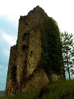
WPaz is a village and ruined castle in Istria County, Croatia, in the municipality of Cerovlje. In 2011, the population of the village is 72.
 W
WPietrapelosa is a castle in the Croatian part of Istria, now ruined. In the medieval period a family took their name from the castle. "Pietrapelosa" comes from the Italian words meaning "hairy stone" after the moss that has always grown on the walls of the castle. It is one of the best-preserved of the Istrian castles.
 W
WPiran is a town in southwestern Slovenia on the Gulf of Piran on the Adriatic Sea. It is one of the three major towns of Slovenian Istria. The town is known for its medieval architecture, with narrow streets and compact houses. Piran is the administrative seat of the Municipality of Piran and one of Slovenia's major tourist attractions. Until the mid-20th century, Italian was the dominant language, but it was replaced by Slovene as demographics shifted.
 W
WPlava Laguna is a Serbo-Croatian phrase meaning "blue lagoon". It is also the name of a tourist group based in Poreč in Istria, Croatia.
 W
WPosert Castle, also known as Šabec (Schabez) and St. Martin, is a ruined fortress near the road between Paz and Šušnjevica, in municipality of Cerovlje, in Istria, Croatia. The ruins of the castle depending on the name are dating back to the 11th century, or 16th century (Šabec), while by archeological evidence to the second half of the 14th century. The castle was vastly devastated in the Uskok War (1615–17). Between 2009 and 2014 the castle was restored. Nearby the castle there is also a small Church of St. Martin from 1367.
 W
WSavudrija Lighthouse is the oldest lighthouse in Croatia, located near to the village of the same name, at the northern end of the Istrian peninsula, close to the Slovenian border which is at the southern end of the Gulf of Trieste. Also known as Cape Savudrija lighthouse, the cape or point being called Punta Salvore in Italian, prior to the Second world war the light was commonly known as the Punta Salvore Lighthouse.
 W
WSečovlje Saltpans Natural Park is a natural park in southwestern Slovenia covering the Sečovlje Saltpans near the village of Sečovlje. The salt evaporation pond covers an area of 16.1 hectares, while saltworks lie along the mouth of the Dragonja River, covering an area of 650 hectares.
 W
WThe Sečovlje Saltworks is the largest Slovenian salt evaporation pond. Along with the Strunjan Saltworks, they are the northernmost Mediterranean saltworks and one of the few where salt is still produced in a traditional way, as well as a wetland of international importance and a breeding place for waterbirds. They are part of the Piran Saltworks and are located at Parecag in Slovenian Istria, the southwest of the country, at the Adriatic Sea, along the mouth of the Dragonja River near Sečovlje.
 W
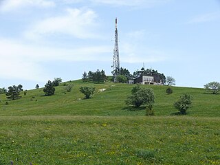
WAt 1,028 metres (3,373 ft) high, Slavnik is one of the highest peaks of the Slovenian Istria. It is part of the Čičarija landscape. Tuma Hut on Slavnik, named after the mountaineer Henrik Tuma, stands about 10 metres (33 ft) below its peak. At its peak stands a broadcast transmitter.
 W
WSlovene Istria is a region in southwest Slovenia. It comprises the northern part of the Istrian peninsula, and it is part of the wider geographical-historical region known as the Slovene Littoral. Its largest urban center is Koper. Other large settlements are Izola, Piran, and Portorož. The entire region has around 120 settlements. In its coastal area, both Slovene and Italian are official languages.
 W
WThe Slovene Riviera is the coastline of Slovenia, located on the Gulf of Trieste, by the Adriatic Sea. It is part of the Istrian peninsula and is 46.6 km long. The region comprises the towns of Koper and Piran with Portorož, and the municipality of Izola. It is a seaside tourist destination, with a vibrant multiethnic Slovenian and Italian heritage.
 W
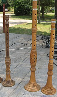
WThe sopile is an ancient traditional woodwind instrument of Croatia, similar to the oboe or shawm. It is used in the regions of Kvarner, Kastav, Vinodol, Island Krk, and Istria. Sopile are always played in pairs so there are great and small or thin and fat sopila. Sopile are musical instrument of sound very interesting possibilities and very piercing special sound. This is replicated in more modern examples of Kvarner music through use of modified double reed clarinet or soprano Dulzaina. Sopile are, by "mih" and "šurle," today very popular in folk tradition of Istria, Kvarner and Island Krk.
 W
WHoly Trinity Church is a historical building in Hrastovlje, a village in southwestern Slovenia. There are two hypotheses about its origin. According to the first, it is a Romanesque church from the 12th century. According to the second, it is an example of the Istrian variant of Early Venetian Renaissance architecture from the 15th century.
 W
WThe Učka is a mountain range in northwestern Croatia. It rises behind the Opatija riviera, on the eastern side of the Istrian peninsula.