 W
WA geoglyph is a large design or motif produced on the ground and typically formed by clastic rocks or similarly durable elements of the landscape, such as stones, stone fragments, gravel, or earth. A positive geoglyph is formed by the arrangement and alignment of materials on the ground in a manner akin to petroforms, while a negative geoglyph is formed by removing part of the natural ground surface to create differently coloured or textured ground in a manner akin to petroglyphs.
 W
WA hill figure is a large visual representation created by cutting into a steep hillside and revealing the underlying geology. It is a type of geoglyph usually designed to be seen from afar rather than above. In some cases trenches are dug and rubble made from material brighter than the natural bedrock is placed into them. The new material is often chalk, a soft and white form of limestone, leading to the alternative name of chalk figure for this form of art.
 W
WThe Alligator Effigy Mound is an effigy mound in Granville, Ohio, United States. The mound is believed to have been built between AD 800 and 1200 by people of the Fort Ancient culture. The mound was likely a ceremonial site, as it was not used for burials.
 W
WThe Atacama Giant is an anthropomorphic geoglyph on Cerro Unitas in the Atacama Desert, Chile. It is the largest prehistoric anthropomorphic figure in the world with a length of 119 metres (390 ft), and represented a deity for the local inhabitants from AD 1000 to 1400.
 W
WBattalion Park is a geoglyph site in southwest Calgary, Alberta, Canada. It is located on Signal Hill, overlooking the Tsuu T'ina Nation, as well as lands formerly known as Camp Sarcee and later Sarcee Training Area, a military reserve used by the Canadian Forces from before the First World War up until the 1990s. The park extends over an area of 93 hectares, north of the Elbow River. Its heritage value is associated with its dedication to the heroic efforts of Albertan soldiers during the First World War. The site contains four geoglyphs, numbered 137, 113, 151, and 51. The large, whitewashed stones, totalling 16,000 in all, form the centrepiece of the park. Arranged on the side of the hill, and visible from various parts of the city, they represent the battalions numbered 137th, 113th, 151st, and 51st.
 W
WThe Battle of Britain Memorial is a monument to aircrew who flew in the Battle of Britain. It is sited on the White Cliffs at Capel-le-Ferne, near Folkestone, on the coast of Kent.
 W
WThe Blythe Intaglios or Blythe Geoglyphs are a group of gigantic figures incised on the ground near Blythe, California, in the Colorado Desert. The ground drawings or geoglyphs were created by humans for an, as yet, unknown reason.
 W
WCraigmillar, from the Gaelic Creag Maol Ard, meaning 'High Bare Rock', is an area of Edinburgh, Scotland, about 3 miles (4.8 km) south east of the city centre, with Duddingston to the north and Newcraighall to the east.
 W
WAn effigy mound is a raised pile of earth built in the shape of a stylized animal, symbol, religious figure, human, or other figure. Effigy mounds were primarily built during the Late Woodland Period.
 W
WEffigy Mounds National Monument preserves more than 200 prehistoric mounds built by Native Americans. Numerous effigy mounds are shaped like animals, including bears and birds. These were built mostly in the first millennium, by peoples of the Woodland Culture. In 2017, they were featured in the America the Beautiful Quarters Program.
 W
WGozan no Okuribi (五山送り火), more commonly known as Daimonji (大文字), is a festival in Kyoto, Japan. It is the culmination of the Obon festival on August 16, in which five giant bonfires are lit on mountains surrounding the city. It signifies the moment when the spirits of deceased family members, who are said to visit this world during O-Bon, are believed to be returning to the spirit world—thus the name Okuribi .
 W
WGroudle Glen Station is the first mandatory stopping point and major station on the Manx Electric Railway which serves the village of Groudle Glen in the Isle of Man, and is situated between Groudle Lane and Eskadale on the route to Laxey and Ramsey.
 W
WJordan Hill Roman Temple is a Romano-Celtic temple and Roman ruin situated on Jordan Hill above Bowleaze Cove in the eastern suburbs of Weymouth in Dorset, England. Original amateur excavations on the site in 1843, by J. Medhurst, were followed by a series of excavations in the 20th century suggesting that the site was in operation between c. AD 69–79 to the late 4th century.
 W
WJulian's Bower or Julian Bower is a name which was given to turf mazes in several different parts of England. Only one of this name still exists, at Alkborough in North Lincolnshire. It has also been known by corrupted forms of the name, such as "Gillian's Bore" and "Gilling Bore".
 W
WThis is a list of hillside letters, large geoglyphs found primarily in the Western United States. There are about 600 in total, but the status of many of these symbols are uncertain, due to vagueness in sources.
 W
WThis is a list of hillside letters in the U.S. state of Montana. There are at least 80 hillside letters, acronyms, and messages in the state, possibly as many as 88. While western Montana provides plenty of mountains to support these monograms, many towns in the eastern prairie have also placed them on whatever hill they can find.
 W
WThe Marree Man, or Stuart's Giant, is a modern geoglyph the circumstances of whose creation have not been ascertained. It appears to depict an Indigenous Australian man hunting with a boomerang or stick. It lies on a plateau at Finnis Springs 60 km (37 mi) west of the township of Marree in central South Australia. It is just outside the 127,000-square-kilometre (49,000 sq mi) Woomera Prohibited Area. The figure is 2.7 km (1.7 mi) tall with a perimeter of 28 km (17 mi), extending over an area of about 2.5 km2. Although it is one of the largest geoglyphs in the world, its origin remains a mystery, with no one claiming responsibility for its creation nor any eye-witness having been found, notwithstanding the scale of the operation required to form the outline on the plateau floor. The description "Stuart's Giant" was used in anonymous faxes sent to media as "Press Releases" in July 1998, in a reference to the explorer John McDouall Stuart. It was discovered fortuitously by a charter pilot in an overflight on 26 June 1998.
 W
WMeggen Lawn Cross is a supposedly supernatural mark of a cross in the ground in Meggen, a village near Argenbühl in Baden-Württemberg, Germany. The Cross first appeared on June 30, 1972 in form of a bald spot in the surrounding field. Later a cross with a length of 3.3 metres and a width of 1.6 metres appeared. The cross reappears each year. Its origin is unknown. Investigations by the University of Hohenheim have been unable to find any cause for the phenomenon.
 W
WMizmaze is the name given to two of England's eight surviving historic turf mazes, and also to a third, presumably once similar site that is now merely a relic. Of the two which survive, one is at Breamore, in Hampshire; the other is on top of St Catherine's Hill, overlooking the city of Winchester, Hampshire.
 W
WMount Zion is a foothill on the eastern flank of the Front Range of the Rocky Mountains of North America. The 7,062-foot (2,152 m) peak is located in Windy Saddle Park,1.7 miles (2.7 km) west of downtown Golden in Jefferson County, Colorado, United States.
 W
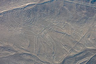
WThe Nazca Lines are a group of very large geoglyphs made in the soil of the Nazca Desert in southern Peru. They were created between 500 BCE and 500 CE by people making depressions or shallow incisions in the desert floor, removing pebbles and leaving differently colored dirt exposed.
 W
WNorthumberlandia is a huge land sculpture in the shape of a reclining female figure, which was completed in 2012, near Cramlington, Northumberland, northern England.
 W
WThe Paracas Candelabra, also called the Candelabra of the Andes, is a well-known prehistoric geoglyph found on the northern face of the Paracas Peninsula at Pisco Bay in Peru. Pottery found nearby has been radio carbon dated to 200 BCE, the time of the Paracas culture. The design is cut two feet (0.61 m) into the soil, with stones possibly from a later date placed around it. The figure is 595 feet tall, large enough to be seen 12 miles (19.3 km) at sea.
 W
WThe Platte Mound M is the letter "M" written using whitewashed stones on Platte Mound about four miles east of Platteville, Wisconsin. It is the largest hillside letter "M" in the world. The letter is 241 feet (73 m) high, 214 feet (65 m) wide, with legs 25 feet (7.6 m) wide.
 W
WRujm el-Hiri is an ancient megalithic monument consisting of concentric circles of stone with a tumulus at center. It is located in the Israeli-occupied portion of the Golan Heights, Syria, some 16 kilometres (9.9 mi) east of the coast of the Sea of Galilee, in the middle of a large plateau covered with hundreds of dolmens.
 W
WThe Russian geoglyph refers to a geoglyph on slopes of the Zyuratkul Mountains in the Chelyabinsk region in Russia.
 W
WThe Sajama Lines [saˈxama] of western Bolivia are a network of thousands of nearly perfectly straight paths etched into the ground continuously for more than 3,000 years by the indigenous people living near the volcano Sajama. They form a web-like network that blankets the Altiplano.
 W
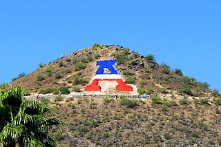
WSentinel Peak is a 2,897 ft peak in the Tucson Mountains southwest of downtown Tucson, Arizona. The valley's first inhabitants grew crops at the mountain's base, along the Santa Cruz River. The name "Tucson" is derived from the O'odham Cuk Ṣon [tʃʊk ʂɔːn], meaning "[at the] base of the black [hill]". In the 1910s, University of Arizona students used local basalt rock to construct a 160-ft-tall block "A" on the mountain's east face, near its summit, giving the peak its other name, "A" Mountain. The peak is part of a 272-acre park, the largest natural resource park in the City of Tucson.
 W
WThe Great Serpent Mound is a 1,348-foot-long (411 m), three-foot-high prehistoric effigy mound on a plateau of the Serpent Mound crater along Ohio Brush Creek in Adams County, Ohio. Maintained within a park by Ohio History Connection, it has been designated a National Historic Landmark by the United States Department of Interior. The Serpent Mound of Ohio was first reported from surveys by Ephraim Squier and Edwin Davis in their historic volume Ancient Monuments of the Mississippi Valley, published in 1848 by the newly founded Smithsonian Museum. The Serpent Mound is the largest serpent effigy in the world.
 W
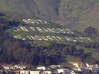
WThe South San Francisco Hillside Sign is a historic sign on a hillside overlooking the city of South San Francisco in San Mateo County, California. It was created in the 1920s and was listed on the National Register of Historic Places in 1996. The sign is the main feature of Sign Hill Park, a city park which provides 30 acres (12 ha) of open space, almost 2 miles (3.2 km) of hiking trails, and access to the letters of the sign itself.
 W
WTempe Butte is the official name of an andesite butte of volcanic origin, located partially on Arizona State University's Tempe campus in Tempe, Arizona. It is often referred to by locals as A Mountain, after the 60-foot-tall (18 m) gold-painted letter 'A' near the top. Another name for the area, used by the City of Tempe, is Hayden Butte.
 W
WTurkey River Mounds State Preserve is a historic site located near the unincorporated community of Millville, Iowa, United States. The 62-acre (25 ha) preserve contains thirty-eight of forty-three Native American mounds located on a narrow Paleozoic Plateau at the confluence of the Mississippi and Turkey rivers. They vary in size and shape and are 1.3 feet (0.40 m) to 6 feet (1.8 m) in height. The conical mounds range from 20 feet (6.1 m) to over 100 feet (30 m) in diameter. The linear mounds vary from 80 feet (24 m) to 175 feet (53 m) in length. There is one effigy mound in the shape of a panther that is 98 feet (30 m) long and 40 feet (12 m) wide. There are also compound mounds in the preserve. The mounds were constructed during the Woodland period. They were used for burials and ceremonial places, and are now protected by law. The preserve is also home to a variety of trees, prairie grasses and flowers.
 W
WWing is a village and civil parish in the East Midlands county of Rutland, England. The population was 315 at the 2001 census and 314 at that of 2011. It features a fine church and a labyrinth made of turf. Rutland Water reservoir is nearby.