 W
WThe Willamette Valley is a 150-mile (240 km) long valley in Oregon, in the Pacific Northwest region of the United States. The Willamette River flows the entire length of the valley, and it is surrounded by mountains on three sides – the Cascade Range to the east, the Oregon Coast Range to the west, and the Calapooya Mountains to the south.
 W
WThe Willamette Valley ecoregion is a Level III ecoregion designated by the United States Environmental Protection Agency in the U.S. states of Oregon and Washington. Slightly larger than the Willamette Valley for which it is named, the ecoregion contains fluvial terraces and floodplains of the Willamette River system, scattered hills, buttes, and adjacent foothills. It is distinguished from the neighboring Coast Range, Cascades, and Klamath Mountains ecoregions by lower precipitation, lower elevation, less relief, and a different mosaic of vegetation. Mean annual rainfall is 37 to 60 inches, and summers are generally dry. Historically, the region was covered by rolling prairies, oak savanna, coniferous forests, extensive wetlands, and deciduous riparian forests. Today, it contains the bulk of Oregon's population, industry, commerce, and agriculture. Productive soils and a temperate climate make it one of the most important agricultural areas in Oregon.
 W
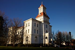
WAlbany is the county seat of Linn County, and the 11th largest city in the U.S. state of Oregon. Albany is located in the Willamette Valley at the confluence of the Calapooia River and the Willamette River in both Linn and Benton counties, just east of Corvallis and south of Salem. It is predominantly a farming and manufacturing city that settlers founded around 1848. As of the 2010 United States Census, the population of Albany was 50,158. Its population was estimated by the Portland Research Center to be 55,338 in 2019.
 W
WBald Hill is a hill in the Willamette Valley west of Corvallis, Oregon. With an elevation of 755 feet (230 m) and a top clear of tree cover, Bald Hill is a popular local hiking destination and lookout, with Corvallis, Mary's Peak, the Coastal Range, and the Cascade Range foothills all visible from atop the hill.
 W
WThe camas pocket gopher, also known as the camas rat or Willamette Valley gopher, is a rodent, the largest member in the genus Thomomys, of the family Geomyidae. First described in 1829, it is endemic to the Willamette Valley of northwestern Oregon in the United States. The herbivorous gopher forages for vegetable and plant matter, which it collects in large, fur-lined, external cheek pouches. Surplus food is hoarded in an extensive system of tunnels. The dull-brown-to-lead-gray coat changes color and texture over the year. The mammal's characteristically large, protuberant incisors are well adapted for use in tunnel construction, particularly in the hard clay soils of the Willamette Valley. The gophers make chattering sounds with their teeth; males and females make purring sounds when they are together, and the young make twittering sounds. Born toothless, blind and hairless, the young grow rapidly before being weaned at about six weeks of age.
 W
WCorvallis is a city and the county seat of Benton County in central western Oregon, United States. It is the principal city of the Corvallis, Oregon Metropolitan Statistical Area, which encompasses all of Benton County. As of the 2010 United States Census, the population was 54,462. Its population was estimated by the Portland Research Center to be 58,856 in 2019. Corvallis is the location of Oregon State University and Good Samaritan Regional Medical Center. At a longitude of 123° 17' west, the city is the westernmost city in the contiguous 48 states with a population larger than 50,000.
 W
WCottage Grove is a city in Lane County, Oregon, United States. The population was 9,686 at the 2010 census. Cottage Grove is the third largest city in Lane County. The city is located on Interstate 5, Oregon Route 99, and the main Willamette Valley line of the CORP railroad.
 W
WDallas is a city and the county seat of Polk County, Oregon, United States. The population was 14,583 at the 2010 census.
 W
WErratic Rock State Natural Site is a state park in the Willamette Valley of Oregon, United States. Featuring a 40-short-ton (36 t) glacial erratic from the Missoula Floods, the small park sits atop a foothill of the Northern Oregon Coast Range in Yamhill County between Sheridan and McMinnville off Oregon Route 18. The day use only park is owned and maintained by the Oregon Parks and Recreation Department.
 W
WEugene is a city in the U.S. state of Oregon, in the Pacific Northwest. It is at the southern end of the verdant Willamette Valley, near the confluence of the McKenzie and Willamette rivers, about 50 miles (80 km) east of the Oregon Coast.
 W
WThe Eyrie Vineyards is an American winery in Oregon that consists of 60 acres (24 ha) in five different vineyards in the Dundee Hills AVA of the Willamette Valley. In 1965, against the advice of his viticultural professors at the University of California, Davis, David Lett moved to Oregon to plant [[Pinot noir] in the Willamette Valley. David and Diana Lett produced the first Pinot noir in the Willamette Valley, and the first Pinot gris in the United States. Their first vintage in 1970.
 W
WThe history of the city of Portland, Oregon, began in 1843 when business partners William Overton and Asa Lovejoy filed to claim land on the west bank of the Willamette River in Oregon Country. In 1845 the name of Portland was chosen for this community by coin toss. February 8, 1851, the city was incorporated. Portland has continued to grow in size and population, with the 2010 Census showing 583,776 residents in the city.
 W
WThe Kalapuya are a Native American ethnic group, which had eight independent groups speaking three mutually intelligible dialects. The Kalapuya tribes' traditional homelands were the Willamette Valley of present-day western Oregon in the United States, an area bounded by the Cascade Range to the east, the Oregon Coast Range at the west, the Columbia River at the north, to the Calapooya Mountains of the Umpqua River at the south.
 W
WKalapuyan is a small extinct language family that was spoken in the Willamette Valley of Western Oregon, United States. It consists of three languages.
WLake Allison was a temporary lake in the Willamette Valley of Oregon, formed periodically by the Missoula Floods from 15,000 to 13,000 BC. The lake is the main cause of the rich and fertile soil that now characterizes the Willamette Valley.
 W
WMcMinnville is the county seat of and largest city in Yamhill County, Oregon, United States. According to Oregon Geographic Names, it was named by its founder, William T. Newby (1820–1884), an early immigrant on the Oregon Trail, for his hometown of McMinnville, Tennessee. As of the 2010 census, the city had a population of 32,187.
 W
WOregon City is the county seat of Clackamas County, Oregon, United States, located on the Willamette River near the southern limits of the Portland metropolitan area. Established in 1829 by the Hudson's Bay Company, in 1844 it became the first U.S. city west of the Rocky Mountains to be incorporated.
 W
WSalem is the capital of the U.S. state of Oregon, and the county seat of Marion County. It is located in the center of the Willamette Valley alongside the Willamette River, which runs north through the city. The river forms the boundary between Marion and Polk counties, and the city neighborhood of West Salem is in Polk County. Salem was founded in 1842, became the capital of the Oregon Territory in 1851, and was incorporated in 1857.
 W
WThe Siskiyou Trail stretched from California's Central Valley to Oregon's Willamette Valley; modern-day Interstate 5 follows this pioneer path. Originally based on existing Native American foot trails winding their way through river valleys, the Siskiyou Trail provided the shortest practical travel path between early settlements in California and Oregon.
 W
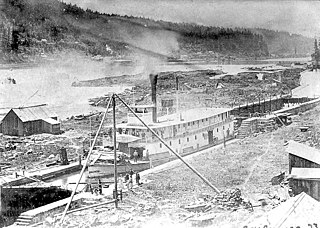
WThe Southern Pacific Red Electric Lines, also known simply as the Red Electric, was a network of interurban passenger train services operated by the Southern Pacific Railroad in the Willamette Valley of the U.S. state of Oregon from 1914 to 1929. The service got its name from the bright red color of its cars. Despite its short history, among West Coast interurbans it was unique, and it was considered the finest such system in the Pacific Northwest. It was the only major electric interurban railroad converted from steam to electric passenger use. It was also one of few systems using all-steel equipment, and one of the largest 1500-volt systems in the country.
 W
WThe Willamette River flows northwards down the Willamette Valley until it meets the Columbia River at a point 101 miles from the Pacific Ocean, in the U.S. state of Oregon.
WThe Treaty with the Kalapuya, etc., also known as the Kalapuya Treaty or the Treaty of Dayton, was an 1855 treaty between the United States and the bands of the Kalapuya tribe, the Molala tribe, the Clackamas, and several others in the Oregon Territory. In it the tribes agreed to cede land in exchange for money. The treaty effectively gave over the entirety of the Willamette Valley to the United States and removed Native Americans in the area. The treaty was signed on January 22, 1855, in Dayton, Oregon, ratified on March 3, 1855, and proclaimed on April 10, 1855.
 W
WThe Van Duzer Corridor AVA, a sub-appellation of the Willamette Valley AVA located within Polk County, Oregon, in the United States, is an American Viticultural Area approved by the Alcohol and Tobacco Tax and Trade Bureau on December 13, 2018 and effective January 14, 2019.
 W
WVertical is a 2010 novel by Rex Pickett and the second novel in the Sideways Trilogy. It is a sequel to the novel Sideways, which was made into a successful 2004 film of the same name.
 W
WThe Willamette Falls is a natural waterfall on the Willamette River between Oregon City and West Linn, Oregon, in the United States. It is the largest waterfall in the Northwestern United States by volume, and the seventeenth widest in the world. Horseshoe in shape, it is 1,500 feet (460 m) wide and 40 feet (12 m) high with a flow of 30,849 cu ft/s, located 26 miles (42 km) upriver from the Willamette's mouth.
 W
WThe Willamette Falls Locks are a lock system on the Willamette River in the U.S. state of Oregon. Opened in 1873 and closed since 2011, they allowed boat traffic on the Willamette to navigate beyond Willamette Falls and the T.W. Sullivan Dam. Since their closure in 2011 the locks are classified to be in a "non-operational status" and are expected to remain permanently closed.
 W
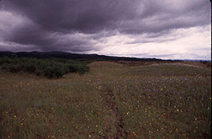
WThe Willamette Floodplain consists of 713 acres (289 ha) of natural grassland, near the Willamette River, that was made a National Natural Landmark in May 1987. The floodplain is within the William L. Finley National Wildlife Refuge and located about 10 miles (16 km) south of Corvallis in Benton County, Oregon.
 W
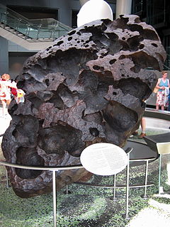
WThe Willamette Meteorite, officially named Willamette and originally known as Tomanowos by the Clackamas Chinook Native American tribe is an iron-nickel meteorite found in the U.S. state of Oregon. It is the largest meteorite found in North America and the sixth largest in the world. There was no impact crater at the discovery site; researchers believe the meteorite landed in what is now Canada or Montana, and was transported as a glacial erratic to the Willamette Valley during the Missoula Floods at the end of the last Ice Age. It has long been held sacred by indigenous peoples of the Willamette Valley, including the federally recognized Confederated Tribes of the Grand Ronde Community of Oregon (CTGRC).
 W
WThe Willamette River is a major tributary of the Columbia River, accounting for 12 to 15 percent of the Columbia's flow. The Willamette's main stem is 187 miles (301 km) long, lying entirely in northwestern Oregon in the United States. Flowing northward between the Oregon Coast Range and the Cascade Range, the river and its tributaries form the Willamette Valley, a basin that contains two-thirds of Oregon's population, including the state capital, Salem, and the state's largest city, Portland, which surrounds the Willamette's mouth at the Columbia.
 W
WThe Willamette Valley AVA, is an American Viticultural Area which lies in the Willamette Valley of Oregon. The AVA is the wine growing region which encompasses the drainage basin of the Willamette River. It stretches from the Columbia River in the north to just south of Eugene in the south, where the Willamette Valley ends; and from the Oregon Coast Range in the west to the Cascade Mountains in the east. At 5,360 square miles (13,900 km2), it is the largest AVA in the state, and contains most of the state's wineries; approximately 200 as of 2006.
WWilliam L. Finley National Wildlife Refuge is a natural area in the Willamette Valley in Oregon, United States. It was created to provide wintering habitat for dusky Canada geese. Unlike other Canada geese, dusky Canada geese have limited summer and winter ranges. They nest on Alaska's Copper River Delta and winter almost exclusively in the Willamette Valley. Habitat loss, predation, and hunting have caused a decrease in population.
 W
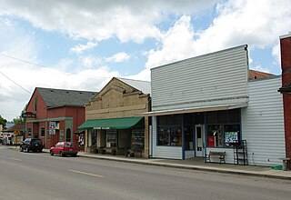
WYamhill is a city in Yamhill County, Oregon, United States. Located in the northern part of the county, it is situated at the intersection of Oregon Route 47 and Oregon Route 240. The population was 1,024 at the 2010 census. Originally named North Yamhill, it was incorporated under that name by the Oregon Legislative Assembly on February 20, 1891.