 W
WAndersen Creek is a meltwater stream, 1.5 kilometres (0.9 mi) long, flowing southwest along the east side of Canada Glacier into the northeast corner of Lake Hoare in Taylor Valley, Victoria Land, Antarctica.
 W
WThe Asgard Range is a mountain range in Victoria Land, Antarctica. It divides Wright Valley from Taylor Glacier and Taylor Valley, and was named by the Victoria University of Wellington Antarctic Expedition (VUWAE) (1958–59) after Asgard, the home of the Norse gods.
WBartley Glacier is a hanging glacier on the south wall of Wright Valley in the Asgard Range of Victoria Land, just west of Meserve Glacier. It was named by the Advisory Committee on Antarctic Names for construction driver Ollie B. Bartley, U.S. Navy, who was killed on January 14, 1957 when the vehicle (weasel) he was driving dropped through the sea ice at Hut Point, McMurdo Sound.
WLake Brownworth is a meltwater lake immediately west of Wright Lower Glacier at the east end of Wright Valley, Victoria Land. The lake was mapped by the United States Geological Survey (USGS) from surveys and air photos obtained in 1956–1960. It was named by the Advisory Committee on Antarctic Names for Frederick S. Brownworth Jr., a USGS topographic engineer who worked several seasons in Antarctica. In 1970–1971 he supervised aerial photography of the dry valleys of Victoria Land, including this lake.
WBull Pass is a low pass through the Olympus Range, between Mount Jason and Mount Orestes, joining McKelvey Valley and Wright Valley in the McMurdo Dry Valleys of Victoria Land, Antarctica. It was named by the Victoria University of Wellington Antarctic Expedition (1958–59) for Colin Bull, who led this expedition. Prospect Mesa is located just below the pass.
WCanada Peak is a sharp peak rising to 1,350 metres (4,430 ft) on the west side of Canada Glacier where it spills into Taylor Valley, Victoria Land. It was named by the New Zealand Geographic Board in 1998, in association with Canada Glacier.
WLake Chad is a small lake lying east of the mouth of Suess Glacier in the Taylor Valley of Victoria Land. It was charted by the British Antarctic Expedition, 1910–13, under Robert Falcon Scott, and named by them after Lake Chad in Africa. A probable urban myth claims that the lake was named by Scott and his expedition after a brand of toilet paper they used following getting sick from drinking the water.
WClow Island is an island 1.1 kilometres (0.6 nmi) long in the eastern part of Lake Fryxell in Taylor Valley, Victoria Land. This feature was a peninsula as recently as the 1980s when the rising level of the lake submerged the eastern part of the peninsula and created the island. It was named by the Advisory Committee on Antarctic Names (2000) after Gary D. Clow of the United States Geological Survey, who studied sand/ice interactions and sediment deposition in perennially ice-covered lakes in Taylor Valley, 1985–86, and glacier geophysics at Taylor Dome, 1993–94 through 1995–96.
 W
WMount Coates is an Antarctic peak, 2,060 metres (6,760 ft) high, just east of Borns Glacier in the Kukri Hills of Victoria Land. It was named by the Western Journey Party, led by Thomas Griffith Taylor, of the British Antarctic Expedition, 1910–13.
 W
WCommonwealth Glacier is a glacier which flows in a southeasterly direction and enters the northern side of Taylor Valley immediately west of Mount Coleman, in Victoria Land, Antarctica. It was charted by the British Antarctic Expedition, 1910–13, under Robert Falcon Scott, and named by them for the Commonwealth of Australia, which made a financial grant to the BrAE and contributed two members to the Western Geological Party which explored this area. The north end of the glacier is bounded by Flint Ridge.
WCrescent Glacier is a small alpine glacier in Antarctica. It is located just east of Howard Glacier in the Kukri Hills, flowing north into Taylor Valley in Victoria Land. The glacier was studied by U.S. geologist Troy L. Pewe in December 1957, and was so named by him because of its crescent shape when viewed from the floor of Taylor Valley.
WDecker Glacier is a steep, narrow glacier that drains the northeast slopes of Mount Newall in the Asgard Range, Victoria Land. It was named by the Advisory Committee on Antarctic Names for Chief Aviation Machinist's Mate William D. Decker, U.S. Navy, of Squadron VXE-6, who died at McMurdo Station on October 11, 1971.
 W
WGarwood Valley is a valley opening on the coast of Victoria Land, Antarctica, just south of Cape Chocolate. It is largely ice-free, but is occupied near its head by the Garwood Glacier. It was named by Thomas Griffith Taylor of the British Antarctic Expedition, 1910–13, in association with Garwood Glacier.
WHart Glacier is a small hanging glacier on the south wall of Wright Valley, Victoria Land, Antarctica, between Meserve Glacier and Goodspeed Glacier. It was named by U.S. geologist Robert Nichols for Roger Hart, a geological assistant to Nichols at nearby Marble Point in the 1959–60 field season.
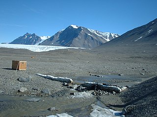
WLake Hoare is a lake about 4.2 kilometres (2.6 mi) long between Lake Chad and Canada Glacier in Taylor Valley, Victoria Land, Antarctica. Its surface area measures 1.94 square kilometres (0.75 sq mi). The lake was named by the 8th Victoria University of Wellington Antarctic Expedition (VUWAE), 1963–64, for physicist Ray A. Hoare, a member of the VUWAE that examined lakes in Taylor, Wright, and Victoria Valleys.
 W
WHuey Creek is a glacial meltwater stream, 1.2 nautical miles (2.2 km) long, flowing south from an ice field west of Mount Falconer to the north-central shore of Lake Fryxell, in Taylor Valley, Victoria Land, Antarctica. The name was suggested by hydrologist Diane McKnight, leader of a United States Geological Survey (USGS) team that made extensive hydrological studies in the Lake Fryxell basin, 1987–94. The name acknowledges support received by the USGS field team in Taylor Valley from U.S. Navy Squadron VXE-6 and its twin engine UH-1N "Huey" helicopters.
WJackson Pond is a freshwater frozen pond midway between the terminus of Wright Upper Glacier and Anvil Pond in the Labyrinth, McMurdo Dry Valleys, Antarctica. It was named by the Advisory Committee on Antarctic Names in 2004 after J.K. Jackson of the Department of Geology at Northern Illinois University, DeKalb, Illinois, a member of the core legging and processing team during the McMurdo Dry Valleys Drilling Project, 1974–75.
WKukri Hills is a prominent east-west trending range, about 25 nautical miles (46 km) long and over 2,000 metres (6,600 ft) high, forming the divide between Ferrar Glacier on the south and Taylor Glacier and Taylor Valley on the north, in Victoria Land, Antarctica.
 W
WThe Labyrinth is an extensive flat upland area which has been deeply eroded, at the west end of Wright Valley, in Victoria Land, Antarctica. It was so named by the Victoria University of Wellington Antarctic Expedition (1958–59) because the eroded dolerite of which it is formed gives an appearance of a labyrinth.
 W
W'Mautino Peak' is a peak at the west side of Packard Glacier in the Saint Johns Range of Victoria Land, Antarctica. It was named by the Advisory Committee on Antarctic Names for Commander Richard L. Mautino, U.S. Navy, officer-in-charge of the Naval Support Force winter-over detachment at McMurdo Station in 1972.
 W
WMiers Valley is a valley in the McMurdo Dry Valleys located just south of Marshall Valley and west of Koettlitz Glacier, on the coast of Victoria Land, Antarctica. The valley is ice-free in the Austral summer except for Miers Glacier and Adams Glacier in its upper (western) part, and Lake Miers near its center. Penance Pass connects it to the valley of Shangri-la.
 W
WLake Miers is a small lake in Miers Valley, Antarctica, lying 1 nautical mile (2 km) east of the snouts of Miers Glacier and Adams Glacier, and filled by meltwater from these glaciers. A stream from the lake flows down the valley in the warmest weather to reach the coast of Victoria Land. The lake was named after Miers Glacier in 1957 by the New Zealand Blue Glacier Party of the Commonwealth Trans-Antarctic Expedition, 1956–58.
 W
WMummy Pond is a pond between Suess and Lacroix Glaciers in Taylor Valley, Victoria Land. So named by T.L. Pewe, U.S. geologist who visited the area in December 1957, because of the mummified seals found around the pond.
WParera Pond is a pond lying 1 nautical mile (1.9 km) south of Andrews Ridge in Taylor Valley, Victoria Land. It was named by the New Zealand Geographic Board in 1998. Parera is the Maori word for wild duck.
WSiegfried Peak is a peak that forms a saddle with Siegmund Peak immediately southward, standing at the east side of the entrance to Odin Valley in the Asgard Range of Victoria Land, in Antarctica. Named after Siegfried, the peak is one in a group of features in the area named after characters Norse mythology by New Zealand Antarctic Place-Names Committee (NZ-APC). Siegfried was the hero of various German legends, particularly of the Nibelungenlied.
WSiegmund Peak is the peak that forms a saddle with Siegfried Peak just northward, located at the east side of the entrance to Odin Valley in Asgard Range, Victoria Land. The name was applied by New Zealand Antarctic Place-Names Committee (NZ-APC) after Siegmund of the Völsunga saga, the father of the German legend hero Siegfried.
 W
WTaylor Valley is the southernmost of the three large Dry Valleys in the Transantarctic Mountains, Victoria Land, located west of McMurdo Sound at approximately 77°37′S 163°00′E. The valley extends from Taylor Glacier in the west to McMurdo Sound at Explorers Cove at the northwest head of New Harbour in the east and is about 29 kilometres (18 mi) long. It was once occupied by the receding Taylor Glacier, from which it derives its name. Taylor Valley contains Lake Bonney in the west (inward), and Lake Fryxell in the east (coastward), and Lake Hoare, Lake Chad, Lake Popplewell, Mummy Pond and Parera Pond close together between the two. Further east of Lake Bonney is Pearse Valley. Taylor Valley is separated from Wright Valley in the north by Asgard Range, and from Ferrar Glacier in the south by Kukri Hills.
 W
WThe Upper Victoria Glacier is a retreating glacier at the head of the Victoria Valley, the northernmost of the McMurdo Dry Valleys of Antarctica. Melt water from the glacier feeds the Victoria River and on from there to Lake Vida.
WLake Vashka is a lake near the center of Barwick Valley, about 4 nautical miles east of Webb Glacier in Victoria Land. It was named by the Victoria University of Wellington Antarctic Expedition (VUWAE) (1958–59) after Vashka (Vaska), a sled dog of the British Antarctic Expedition, 1910–13.
 W
WWall Valley is an upland valley next east of Priscu Valley in Olympus Range; Minotaur Pass is at the head between Apollo Peak and Mount Electra. The valley opens north to McKelvey Valley. Named by Advisory Committee on Antarctic Names (US-ACAN) (2004) after Diana Wall, Natural Resources Ecology Laboratory, Colorado State University, Fort Collins, CO; United States Antarctic Program (USAP) soils biologist in the McMurdo Dry Valleys, 13 field seasons, 1989–2002, most of them as a principal investigator in the McMurdo Dry Valleys Long-term Ecological Research program.
 W
WWright Upper Glacier is an ice apron at the upper west end of Wright Valley in Asgard Range, Antarctica. It is formed by a glacier flowing east from the inland ice plateau. Named by the Victoria University of Wellington Antarctic Expedition (VUWAE) (1958–59) for C.S. Wright, a member of the British Antarctic Expedition (1910–13), after whom the "Wright Glacier" was named.
 W
WThe Wright Valley, named for Sir Charles Wright, is the central one of the three large Dry Valleys in the Transantarctic Mountains, located west of McMurdo Sound at approximately 77°10′S 161°50′E. Wright Valley contains the Onyx River, the longest river in Antarctica, Lake Brownworth, the origin of Onyx River, and Lake Vanda, which is fed by the Onyx River. Its southwestern branch, South Fork, is the location of Don Juan Pond. The upland area known as the Labyrinth is at the valley's west end.