 W
WThe Illinois River is a principal tributary of the Mississippi River and is approximately 273 miles (439 km) long. Located in the U.S. state of Illinois, the river drains a large section of central Illinois, with a drainage basin of 28,756.6 square miles (74,479 km2). The drainage basin extends into Wisconsin, Indiana, and a very small area of southwestern Michigan.
 W
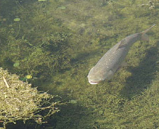
WIntroduced Asian carp in North America pose a major threat to the ecology, environment, economy, and way of life in the Upper Midwest and Great Lakes region of the United States and Canada. Asian carp are a group of fish species, which include several known to be invasive, and represent the most urgent potential danger to the ecology of the Great Lakes. The United States Department of the Interior and United States Fish and Wildlife Service presented their first annual report to Congress on the issue in December 2014.
 W
WThe Chautauqua National Wildlife Refuge is located on the Illinois River in Mason County northeast of Havana, Illinois. It is managed by the U.S. Fish and Wildlife Service as one of the four Illinois River National Wildlife and Fish Refuges.
 W
WDes Plaines Fish and Wildlife Area is an Illinois state park on 5,000 acres (2,023 ha) in Will County, Illinois, United States. It is located on floodplain adjacent to the confluence of the Des Plaines River and the Kankakee River to form the Illinois River.
 W
WDresden Generating Station is the first privately financed nuclear power plant built in the United States. Dresden 1 was activated in 1960 and retired in 1978. Operating since 1970 are Dresden units 2 and 3, two General Electric BWR-3 boiling water reactors. Dresden Station is located on a 953-acre (386 ha) site in Grundy County, Illinois, at the head of the Illinois River, near the city of Morris. It is immediately northeast of the Morris Operation—the only de facto high-level radioactive waste storage site in the United States. It serves Chicago and the northern quarter of the state of Illinois, capable of producing 867 megawatts of electricity from each of its two reactors, enough to power over one million average American homes.
 W
WThe Emiquon National Wildlife Refuge is a 11,122-acre (45.01 km2) wetland wildlife refuge located in Waterford Township in Fulton County, Illinois across the Illinois River from the town of Havana. Only 3,000 acres (12 km2) are currently managed by the U.S. Fish and Wildlife Service as part of the Illinois River National Wildlife and Fish Refuges Complex. It is in the Central forest-grasslands transition ecoregion.
 W
WFort Crevecoeur was the first public building erected by Europeans within the boundaries of the modern state of Illinois and the first fort built in the West by the French. It was founded on the east bank of the Illinois River, in the Illinois Country near the present site of Creve Coeur, a suburb of Peoria, Illinois, in January 1680. It was destroyed on 16 April of that same year by members of La Salle's expedition, who were fearful of being attacked by the Iroquois as the Beaver Wars extended into the area.
 W
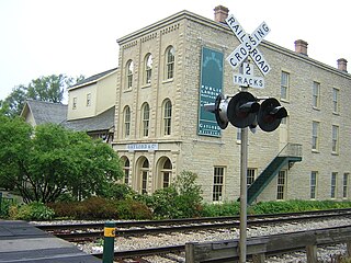
WThe Gaylord Building, constructed in 1838 in the downtown historic district of Lockport, Illinois, and on the canalside there, played a pivotal role in the construction of the Illinois and Michigan Canal. It is on the United States National Register of Historic Places, and is one of 29 Historic Sites of the National Trust for Historic Preservation. It is constructed of yellow limestone, a common construction material in north central Illinois. It has an Italianate three story addition added in 1859. After falling into disrepair, it was the focus of a concerted restoration and preservation effort that began in 1983, which was later noted as setting a model for such efforts.
 W
WThe Grand Village of the Illinois, also called Old Kaskaskia Village, is a site significant for being the best documented historic Native American village in the Illinois River valley. It was a large agricultural and trading village of Native Americans of the Illinois confederacy, located on the north bank of the Illinois River near the present town of Utica, Illinois. French explorers Louis Joliet and Father Jacques Marquette came across it in 1673. The Kaskaskia, a tribe of the Illiniwek people lived in the village. It grew rapidly after a mission and fur trading post were established there in 1675, to a population of about 6,000 people in about 460 houses. Around 1691 the Kaskaskia and other Illiniwek moved further south, abandoning the site due to pressure from an Iroquois invasion from the northeast.
 W
WGrandview Drive is a two and a half mile scenic road with adjacent park areas through Peoria and Peoria Heights, Illinois. Major portions of the road give a view of the Illinois River and its valley as well as clear views of some of the most prestigious and historic homes in the area. Houses along Grandview Drive are among the best known in the city; the residential area on the west of Grandview Drive, opposite the river, was added to the National Register of Historic Places as an historic district in 1996. A large amount of land on the valley side of Grandview Drive is owned by the Peoria Park District and is undeveloped except for park benches. The district's legal name, "Pleasure Driveway and Park District of Peoria", is a reflection of Grandview Drive's original prominence in the Peoria park system. Of particular note, the drive is said to have been one of the first "linear parks" of its time.
 W
WThe Hennepin Canal State Trail, also just called the Hennepin Canal, is an abandoned waterway in northwest Illinois, between the Mississippi River at Rock Island and the Illinois River near Hennepin. The entire canal is listed on the National Register of Historic Places.
 W
WThe Illinois and Michigan Canal connected the Great Lakes to the Mississippi River and the Gulf of Mexico. In Illinois, it ran 96 miles (154 km) from the Chicago River in Bridgeport, Chicago to the Illinois River at LaSalle-Peru. The canal crossed the Chicago Portage, and helped establish Chicago as the transportation hub of the United States, before the railroad era. It was opened in 1848. Its function was largely replaced by the wider and shorter Chicago Sanitary and Ship Canal in 1900, and it ceased transportation operations with the completion of the Illinois Waterway in 1933.
 W
WThe Julia Belle Swain is a steam-powered sternwheeler currently under restoration in La Crosse, Wisconsin, US.
 W
WThe Marseilles Hydro Plant, also known as the Marseilles Hydro Development or the Marseilles Hydro Power Station, is a historic hydroelectric power station along the Illinois River in Marseilles, Illinois, USA.
 W
WThe Marseilles Lock and Dam, also known as Lock and Dam 5, is a lock and dam complex on the Illinois River at Marseilles, Illinois. The complex includes a lock, dam, control station, boiler house, and a 2.5 miles (4.0 km) section of navigation canal. The state of Illinois began work on the complex in 1920 by digging the canal, which was completed in 1925. The state also began construction on the lock, dam, and control station; however, due to financial difficulties these projects were finished by the U.S. Army Corps of Engineers. Walter Mickle Smith was chief design engineer for the complex. The complex was completed in 1933. The lock has a drop of 24 feet.
 W
WThe Meeting of the Great Rivers Scenic Route extends for 33.0 miles (53.1 km) in southwestern Illinois, travelling through the floodplain of the Mississippi and Illinois Rivers. The route has been officially designated as a National Scenic Byway by the Federal Highway Administration. The route coincides with a portion of the Great River Road.
 W
WMeredosia Lake is a riparian lake that forms part of the valley of the Illinois River. It is located in Cass and Morgan Counties, Illinois. Much of the floodplain isthmus between Lake Meredosia and the river is known as Meredosia Island, and much of the quasi-island and associated lakebed are part of the Meredosia National Wildlife Refuge.
WThe Meredosia National Wildlife Refuge is a 5,255-acre (21.27 km2) national wildlife refuge located along the Illinois River in Cass County and Morgan County in the U.S. state of Illinois. The refuge is adjacent to Meredosia, Illinois, but is managed by the U.S. Fish and Wildlife Service from a headquarters located in Havana, Illinois.
WPeoria Lake is a section of the Illinois River between Peoria in Peoria County, Illinois and East Peoria in Tazewell County, Illinois. The oldest section of Peoria, the largest city on the river, lies at its shores.
 W
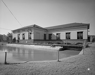
WThe Peoria Lock and Dam is a historic lock and dam complex on the Illinois River at Creve Coeur, Illinois. The complex was built in 1938-39 as part of an effort to make the river navigable and establish a route for barges between Chicago and the Mississippi River. The U.S. Army Corps of Engineers designed the complex; their influence is particularly evident in the dam's control station, as the State of Illinois designed most other dam control stations along the river. The lock has a standard 100-by-600-foot chamber, similar to other locks on the river, and a vertical lift of 11 feet (3.4 m). The dam is 536 feet (163 m) long and includes 108 wicket gates and a Tainter gate; it is one of two Illinois dams that still use wicket gates. The control station is for the most part a large, functional building, though it has Art Deco surrounds at the main entrance. The district also contains an original maneuver boat designed to raise and lower the dam's wicket gates; the boat is still used and is one of four boats of its kind left in the United States.
 W
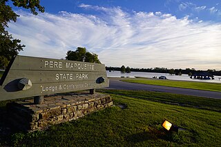
WPere Marquette State Park is an 8,050-acre (3,260 ha) protected area in southwestern Jersey County, Illinois, United States. It is located near the city of Grafton, Illinois, at the confluence of the Mississippi River and the Illinois River. The park is located on Illinois Route 100, which at this location is also part of both the Great River Road and the Meeting of the Great Rivers Scenic Byway. The park is operated and maintained by the Illinois Department of Natural Resources, and is Illinois' largest state park in area. The park is also part of the Confluence Greenway and is at the northwestern end of the 21.5-mile (34.6 km) Sam Vadalabene Bike Trail.
 W
WThe Plum Island Eagle Sanctuary is a 52-acre island in the Illinois River owned by the Illinois Audubon Society. It was purchased March 24, 2004 to act as a wildlife sanctuary, to protect foraging habitat for wintering bald eagles. It is close to Matthiessen State Park and adjacent to Starved Rock State Park.
WThe Ray Norbut State Fish and Wildlife Area is a 1,140-acre (460 ha) state park located near Griggsville in Pike County, Illinois. It borders on the Illinois River and is primarily made of steeply sloped bluffland that is part of the river's valley. Heavily wooded, this region is managed for whitetail deer hunting. The Ray Norbut complex also includes Big Blue Island, a 100-acre (40 ha) riparian island in the Illinois River. The park is managed by the Illinois Department of Natural Resources (IDNR).
WSand Ridge State Forest is a conservation area located in the U.S. state of Illinois. Containing 7,200 acres (2,900 ha), it is the largest state forest in Illinois. It is located in northern Mason County. The nearest town is Manito, Illinois and the nearest numbered highway is U.S. Highway 136. It is located on a low bluff, or "sand ridge", overlooking the Illinois River, hence the name. The sand ridge is believed to be an artifact of the post-glacial Kankakee Torrent.
WSenachwine Lake is a 3,324-acre (13.5 km²) riparian lake that forms part of the valley of the Illinois River. It is located in Putnam and Marshall Counties, Illinois. Its elevation is 439 feet above sea level. Senachwine Lake is connected by a shallow channel to adjacent Goose Lake, also a backwater lake of the Illinois River.
 W
WSpirit of Peoria is a riverboat that normally runs in the Peoria, Illinois area on the Illinois River watershed. The boat participated in the 2004 Grand Excursion. Spirit of Peoria is a true paddleboat, actually using its paddlewheel for propulsion, unlike some modern riverboats with purely cosmetic wheels.
WSpring Lake State Fish and Wildlife Area is an Illinois state park on 2,032 acres (822 ha) in Tazewell County, Illinois, United States.
 W
WStarved Rock Lock and Dam, also known as Lock and Dam No. 6, is a lock and dam facility managed by the U.S. Army Corps of Engineers along the Illinois River. It is part of the Illinois Waterway and was constructed between 1926 and 1933. The lock and dam was added to the National Register of Historic Places as the Starved Rock Lock and Dam Historic District in 2004.
 W
WStarved Rock State Park is a state park in the U.S. state of Illinois, characterized by the many canyons within its 2,630 acres (1,064 ha). Located just southeast of the village of Utica, in Deer Park Township, LaSalle County, Illinois, along the south bank of the Illinois River, the park hosts over two million visitors annually, the most for any Illinois state park.
 W
WThe Two Rivers National Wildlife Refuge is located on the Illinois River and the Mississippi River in parts of Calhoun, Jersey, and Greene counties in Illinois, and St. Charles County, Missouri. It is managed by the U.S. Fish and Wildlife Service as part of the Mark Twain National Wildlife Refuge Complex.
WUpper Peoria Lake is a section of the Illinois River primarily between Peoria County and Woodford County, Illinois, United States. The lake runs from South Rome to Peoria Heights, with Spring Bay and the Detweiller Marina area of Peoria near the middle. Just north of Peoria Heights, it empties through a narrow part of the Illinois River into the smaller Peoria Lake, sometimes called Lower Peoria Lake.
WWoodford State Fish and Wildlife Area is an Illinois state park on 2,900 acres (1,200 ha) of area Woodford County, Illinois, United States. Most of this protected area is over the Goose Lake and Upper Peoria Lake sections of the Illinois River.