 W
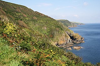
WThe Cornish Killas is a natural region covering most of the county of Cornwall in southwest England. It has been designated as National Character Area 152 by Natural England.
 W
WThe River Allen in north Cornwall is one of two rivers in Cornwall which share this name. In this case the name is the result of a mistake made in 1888 by Ordnance Survey, replacing the name Layne with Allen which is the old name for the lower reaches of the Camel. The other River Allen runs through Truro.
 W
WBin Down is a hill, 203 metres (666 ft) high near Liskeard in the county of Cornwall, England. Its prominence of 101 metres qualifies it as a HuMP.
 W
WBodmin is a civil parish and historic town in Cornwall, England, United Kingdom. It is situated south-west of Bodmin Moor.
 W
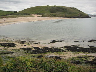
WBrea Hill, pronounced "Bray Hill" is a round hill beside the River Camel estuary in north Cornwall, England, United Kingdom The hill is 62 metres (203 ft) high and there are Bronze Age tumuli at the summit. The underlying geology in this area of Cornwall is Devonian slates.
 W
WCamborne is a town in Cornwall, England. The population at the 2011 Census was 20,845. The northern edge of the parish includes a section of the South West Coast Path, Hell's Mouth and Deadman's Cove.
 W
WThe River Camel is a river in Cornwall, England, United Kingdom. It rises on the edge of Bodmin Moor and with its tributaries its catchment area covers much of North Cornwall. The river flows into the eastern Celtic Sea between Stepper Point and Pentire Point having covered about 30 miles, making it the second longest river wholly in Cornwall. The river is tidal upstream to Egloshayle and is popular for sailing, birdwatching and fishing. The name Camel comes from the Cornish language for 'the crooked one', a reference to its winding course. Historically the river was divided into three named stretches. Heyl was the name for the estuary up to Egloshayle, the River Allen was the stretch between Egloshayle and Trecarne, whilst the Camel was reserved for the stretch of river between its source and Trecarne.
 W
WCastle Downs is a dome-shaped hill, 216 metres (709 ft) high, located in mid Cornwall, UK. There is a major hillfort, Castle an Dinas, on the summit and extensive and panoramic views across the county to both north and south coasts.
 W
WCondolden is a hill in north Cornwall, England, UK. The summit is 308 metres above ordnance datum.
 W
WThe River Fal flows through Cornwall, England, rising at Pentevale on Goss Moor and reaching the English Channel at Falmouth. On or near the banks of the Fal are the castles of Pendennis and St Mawes as well as Trelissick Garden. The River Fal separates the Roseland peninsula from the rest of Cornwall. Like most of its kind on the south coast of Cornwall and Devon, the Fal estuary is a classic ria, or drowned river valley. The Fal estuary from Tregony to the Truro River was originally called Hafaraell.
 W
WFalmouth is a town, civil parish and port on the River Fal on the south coast of Cornwall, England, United Kingdom. It has a total resident population of 21,797.
 W
WFowey is a small town, civil parish and cargo port at the mouth of the River Fowey in south Cornwall, England, United Kingdom. The town has been in existence since well before the Norman invasion, with the local church first established some time in the 7th century; the estuary of the River Fowey forms a natural harbour which enabled the town to become an important trading centre. Privateers also made use of the sheltered harbourage. The Lostwithiel and Fowey Railway brought China clay here for export.
 W
WThe River Fowey is a river in Cornwall, England, United Kingdom.
 W
WGoss Moor is a national nature reserve in Cornwall, England, 12 kilometres (7.5 mi) south-west of Bodmin in the parishes of St Dennis, St Columb Major, Roche and St Enoder. It is the largest continuous mire complex in south-west Britain and consists of mainly peatland and lowland heath. Together with the neighbouring moor to the east, it forms the Goss And Tregoss Moors Site of Special Scientific Interest (SSSI), as well as the Breney Common and Goss and Tregoss Moors Special Area of Conservation (SAC).
 W
WHayle is a small town, civil parish and cargo port in west Cornwall, United Kingdom. It is situated at the mouth of the Hayle River and is approximately seven miles (11 km) northeast of Penzance.
 W
WHelston is a town and civil parish in Cornwall, England, United Kingdom. It is situated at the northern end of the Lizard Peninsula approximately 12 miles (19 km) east of Penzance and 9 miles (14 km) south-west of Falmouth. Helston is the most southerly town on the island of Great Britain and is around 1.5 miles (2.4 km) farther south than Penzance. The population in 2011 was 11,700.
 W
WThe River Inny is a small river in east Cornwall, United Kingdom. It is a tributary of the River Tamar and is about twenty miles (32 km) long from its source near Davidstow on the eastern flank of Bodmin Moor to its confluence with the Tamar at Inny Foot near Dunterton.
 W
WKit Hill, at 334 metres high, dominates the area between Callington and the River Tamar in southeast Cornwall, England, UK. The word 'Kit' comes from Old English for kite, a reference to birds of prey. Buzzards and sparrowhawks can still be seen on the hill. It is one of five Marilyn hills in Cornwall, the four others are Watch Croft, Brown Willy, Carnmenellis and Hensbarrow Beacon.
 W
WLiskeard is an ancient stannary and market town and civil parish in south east Cornwall, England, United Kingdom.
WThe River Lynher flows through east Cornwall, England, and enters the River Tamar at the Hamoaze, which in turn flows into Plymouth Sound.
 W
WNewquay is a town on the north coast in Cornwall, in the south west of England. It is a civil parish, seaside resort, regional centre for aerospace industries, future spaceport and a fishing port on the North Atlantic coast of Cornwall, approximately 12 miles (19 km) north of Truro and 20 miles (32 km) west of Bodmin.
 W
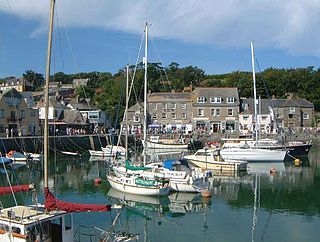
WPadstow is a town, civil parish and fishing port on the north coast of Cornwall, England, United Kingdom. The town is situated on the west bank of the River Camel estuary approximately 5 miles (8.0 km) northwest of Wadebridge, 10 miles (16 km) northwest of Bodmin and 10 miles (16 km) northeast of Newquay. The population of Padstow civil parish was 3,162 in the 2001 census, reducing to 2,993 at the 2011 census. In addition an electoral ward with the same name exists but extends as far as Trevose Head. The population for this ward is 4,434
 W
WPenzance is a town, civil parish and port in the Penwith district of Cornwall, United Kingdom. It is the most westerly major town in Cornwall and is about 64 miles (103 km) west-southwest of Plymouth and 255 miles (410 km) west-southwest of London. Situated in the shelter of Mount's Bay, the town faces south-east onto the English Channel, is bordered to the west by the fishing port of Newlyn, to the north by the civil parish of Madron and to the east by the civil parish of Ludgvan. The civil parish includes the town of Newlyn and the villages of Mousehole, Paul, Gulval, and Heamoor. Granted various royal charters from 1512 onwards and incorporated on 9 May 1614, it has a population of 21,200.
 W
WRedruth is a town and civil parish in Cornwall, England. The population of Redruth was 14,018 at the 2011 census. In the same year the population of the Camborne-Redruth urban area, which also includes Carn Brea, Illogan and several satellite villages, stood at 55,400 making it the largest conurbation in Cornwall. Redruth lies approximately at the junction of the A393 and A3047 roads, on the route of the old London to Land's End trunk road, and is approximately 9 miles (14 km) west of Truro, 12 miles (19 km) east of St Ives, 18 miles (29 km) north east of Penzance and 11 miles (18 km) north west of Falmouth. Camborne and Redruth together form the largest urban area in Cornwall and before local government reorganisation were an urban district.
 W
WThe River Hayle is a small river in West Cornwall, England, United Kingdom which issues into St Ives Bay at Hayle on Cornwall's Atlantic coast.
WThe River Tiddy is a small river in south-east Cornwall, the main tributary of the River Lynher. The Tiddy rises near Pensilva and flows south east past the village of Tideford until it joins the Lynher just after passing St Germans. The name of Tideford derives from its location on the river, literally meaning "Ford on the River Tiddy".
 W
WSt Austell is a town in Cornwall, England, UK, 10 miles (16 km) south of Bodmin and 30 miles (48 km) west of the border with Devon.
 W
WSaltash is a town and civil parish in southeast Cornwall, England, UK. It has a population of 16,184 at the 2011 census. It lies in the south east of Cornwall, facing Plymouth over the River Tamar. It was in the Caradon district until March 2009 and is known as "the Gateway to Cornwall". Saltash is best known for Isambard Kingdom Brunel's Royal Albert Bridge, a towering 134-foot bridge, constructed in the 1850s, which frequently transports trains over the River Tamar.
 W
WThe Tamar is a river in south west England, that forms most of the border between Devon and Cornwall. The area is a World Heritage Site due to its historic mining activities.
 W
WTregonning Hill is the westerly of two granite hills overlooking Mount's Bay in west Cornwall, England, United Kingdom, the other being Godolphin Hill. They are approximately 6 kilometres (3.7 mi) west of the town of Helston. The Plymouth chemist William Cookworthy mixed china stone with kaolin, mined from the hill to make Plymouth porcelain; which was the first time porcelain was made in Europe. Part of the hill is designated as a Site of Special Scientific Interest (SSSI) and at the date of notification (1994) was the only known site of western rustwort in Great Britain.
 W
WTruro is a cathedral city and civil parish in Cornwall, England, UK. It is Cornwall's county town and only city, as well as being its centre for administration, leisure and retail. Its population was recorded as 18,766 in the 2011 census. People from Truro are known as Truronians. Truro grew as a centre of trade from its port and then as a stannary town for the tin-mining industry. It became entitled to be called a city in 1876, with the founding of the Diocese of Truro, and thereby became mainland Britain's southernmost city. Places of interest include the Royal Cornwall Museum, Truro Cathedral, the Hall for Cornwall, and Cornwall's Courts of Justice.
 W
WWadebridge is a town and civil parish in north Cornwall, England, United Kingdom. The town straddles the River Camel 5 miles (8.0 km) upstream from Padstow. The permanent population was 6,222 in the census of 2001, increasing to 7,900 in the 2011 census. There are two electoral wards in the town. Their total population is 8,272