 W
WThe following is a list of mountains in Thailand. The elevations are in metres. Latin script uses the Royal Thai General System of Transcription.
 W
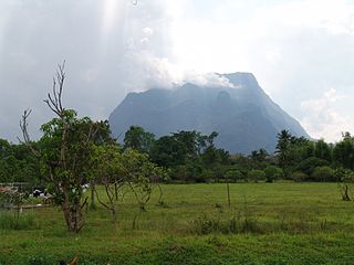
WDoi Chiang Dao, also known as Doi Luang Chiang Dao, is a 2,175 metres (7,136 ft) high mountain in Chiang Dao District of Chiang Mai Province, Thailand. It is one of the highest peaks of the Daen Lao Range on the Thai side of the border.
 W
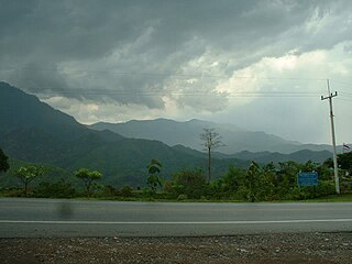
WDoi Ian is a mountain in Thailand, part of the Phi Pan Nam Range, at the southeastern end of Chiang Rai Province limit near the point where the limit of this province meets with the northern end of Phayao Province, nine km from the border with Laos.
 W
WDoi Inthanon is the highest mountain in Thailand. It is in Chom Thong District, Chiang Mai Province. This mountain is an ultra prominent peak, known in the past as Doi Luang or Doi Ang Ga, meaning the 'crow's pond top'. Near the mountain's base was a pond where many crows gathered. The name Doi Inthanon was given in honour of Inthawichayanon, last King of Chiang Mai, who was concerned about the forests in the north and tried to preserve them. He ordered that after his death his remains be interred at Doi Luang, which was then renamed in his honour.
 W
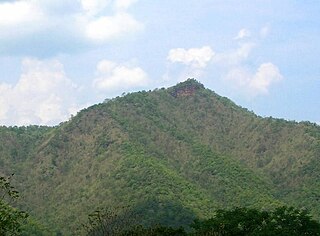
WDoi Lan is a mountain in Thailand, part of the Phi Pan Nam Range, in the center of Chiang Rai Province, south of Chiang Rai Town. With a height of 559 metres Doi Lan gives its name to the Doi Lan Subdistrict of Mueang Chiang Rai District.
 W
WDoi Luang is a 1,694 m high mountain in Thailand, part of the Phi Pan Nam Range.
 W
WDoi Mae Salong is a mountain in Thailand, part of the Daen Lao Range. It is in the northern part of Chiang Rai Province six km. from the border with Burma.
WDoi Mae Tho, also known as Doi Langka Luang (ดอยลังกาหลวง) or Doi Lang Ka (ดอยลังกา), is a mountain in Thailand, part of the Khun Tan Range.
 W
WDoi Nang Non is a mountain range in the Thai highlands in Chiang Rai Province, Thailand. It is a karstic formation with numerous waterfalls and caves rising at the southern end of the Daen Lao Range. Part of its area is managed as the Tham Luang–Khun Nam Nang Non Forest Park.
 W
WDoi Phi Pan Nam, Thai: ดอยผีปันน้ำ, is a 1,745 m high mountain in Southeast Asia, part of the Luang Prabang Range (ทิวเขาหลวงพระบาง).
 W
WDoi Phu Kha Thai: ดอยภูคา, is a mountain in Southeast Asia, part of the Luang Prabang Range (ทิวเขาหลวงพระบาง).
WDoi Suthep (ดอยสุเทพ), is a mountain ("doi") west of Chiang Mai, Thailand. It is 1,676 metres (5,499 ft) in elevation and is one of the twin peaks of a granite mountain. The other peak is known as Doi Pui and is slightly higher.
 W
WDoi Tung (ดอยตุง) is a mountain in the Thai highlands of Mae Fa Luang District, Chiang Rai Province, Thailand.
 W
WKhao Chang (เขาช้าง), is a 45 m high hill in Phang Nga Province, Thailand. It is in Phang Nga town behind city hall.
 W
WKhao Chang Phueak is a mountain in Thailand's Thong Pha Phum National Park. It is in Pilok Subdistrict, Thong Pha Phum District, Kanchanaburi Province. Khao Chang Phueak is 1,249 meters (4,098 ft) in elevation and it is the third highest mountain in Kanchanaburi.
 W
WKhao Kho, is a 1143 m high mountain in Phetchabun Province, Thailand. It is in Khao Kho District. The mountain is part of the western range of the Phetchabun Mountains.
WKhao Luang (เขาหลวง) is the tallest mountain in southern Thailand. It is in Nakhon Si Thammarat Province.
 W
WKhao Nom Nang, "female breast mountain", is a 752 metres (2,467 ft) high mountain in the Tenasserim Hills in Kanchanaburi Province, Thailand.
WKhao Nom Sao (เขานมสาว), "female breast mountain", is a land feature located in Ranong Province, Thailand.
 W
WKhao Ok Thalu or Phukhao Ok Thalu (ภูเขาอกทะลุ), is a mountain in Phatthalung Province, Thailand. It is a karstic formation.
 W
WKhao Rom is a 1,351-metre-high (4,432 ft) mountain in Nakhon Ratchasima Province, Thailand. It is the highest peak of the Sankamphaeng Range, between eastern Thailand and Isan.
 W
WKhao Sam Muk, is a 45 m high hill in Chonburi Province, Thailand. It is in Chonburi city on Bangkok Bay between Ang Sila and Bang Saen Beach. There is a Chinese shrine of Mazu on the hilltop which affords views of the surrounding landscape, including Bang Saen Beach, and there is another shrine at the foot of the escarpment. This shrine is a Thai shrine built according to the legend of this hill.
WPhou Khe is a mountain in Southeast Asia, part of the Luang Prabang Range (ทิวเขาหลวงพระบาง).
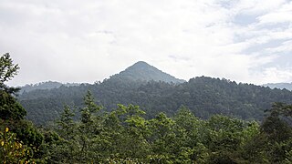
WPhu Chi Fa, also Phu Chee Fah, is a mountain area and national forest park in Thailand. It is located at the northeastern end of the Phi Pan Nam Range, 12 km to the southwest of Doi Pha Tang at the eastern edge of Thoeng District, Chiang Rai Province.
WPhu Khi Suk is a 753-metre-high (2,470 ft) mountain in Ubon Ratchathani Province, Thailand.
 W
WPhu Kradueng, is a 1316 m high mountain in Loei Province, Thailand. It is in Phu Kradueng District, giving its name to the district. Its west side borders Nam Nao District of Phetchabun Province. This mountain is part of the Phetchabun Mountains, a massif forming a natural boundary between North Thailand and Isan.
 W
WPhu Ruea, is a 1365 m high mountain in Loei Province, Thailand. It is in Phu Ruea District. This mountain is part of the Phetchabun Mountains, a massif forming a natural boundary between northern Thailand and Isan. The peak rises seven kilometers north of Highway 203, between Loei town and Phetchabun. The name of the mountain comes from the fact that it looks like a boat upside down from certain angles.
WPhu Soi Dao is a mountain in Southeast Asia. It is 2120 metres tall and rises at the south end of the Luang Prabang Range, on the border between Laos and Thailand. Phu Soi Dao National Park is on the Thai side of the range in Phitsanulok and Uttaradit Provinces.
 W
WPhu Thap Boek is a 1,768 m high mountain in Phetchabun Province, Thailand near the border with Loei Province. It is in the Lom Kao District.
 W
WPhu Thok, meaning 'lonely mountain' in the Isan language, is a 359 m high isolated hill in the northeastern end of Isan, Thailand. It is in Na Sabaeng Subdistrict, Si Wilai District, at the centre of Bueng Kan Province.
WUlu Titi Basah is the southernmost high peak of Thailand. This 1,533 m high peak is located on the Malaysia-Thailand border between Betong District of Yala Province and Hulu Perak in Perak State.