 W
WThe Agongdian River is a river in Taiwan.
 W
WThe Ailiao River is a tributary of the Gaoping River in Taiwan. It flows through Kaohsiung City and Pingtung County for 68.5 km.
 W
WThe Banping Lake Wetland Park is a constructed wetland in Zuoying District, Kaohsiung, Taiwan.
 W
WThe Baolai Spring Park is a hot spring in Baolai Village, Liouguei District, Kaohsiung, Taiwan.
 W
WThe Chiayi–Tainan, Chianan or Jianan Plain, is an alluvial plain located at the central-southern region of western Taiwan. It is the largest plain of the island, and lies in Tainan City and Chiayi County/Chiayi City, from which the name of the plain derived. It also includes some portions of Yunlin County, Changhua County, and Kaohsiung City. There are several rivers flowing through it, such as the Zengwun River.
 W
WThe Chienchen River is a river in Kaohsiung, Taiwan.
WCloud Peak or Yunfeng is a mountain in the Central Mountain Range of Taiwan with an elevation of 3,564 m (11,693 ft).
 W
WThe Dianbao River is a river in Taiwan. It flows through Kaohsiung City for 32 km.
 W
WThe Erren River (Chinese: 二仁溪; pinyin: Èrrén Xī; Wade–Giles: Er4-jen2 Hsi1) is a river in Taiwan. It flows through Tainan City and Kaohsiung City for 61 km. The river originates from the Neimen District in Kaohsiung City and flows through seven districts before it enters Taiwan Strait. The river has suffered from pollution, although the situation has improved.
 W
WThe Gaoping River, also spelled Kaoping River, is a major river of southern Taiwan, flowing through Pingtung County and Kaohsiung City. It is the largest river in Taiwan by drainage area. The river is 171 kilometres (106 mi) long, draining a rugged area on the western side of the Central Mountain Range.
 W
WMount Guan is a mountain in the Central Mountain Range of Taiwan with an elevation of 3,666 m (12,028 ft).
 W
WThe Houjin River is a river in Nanzih District, Renwu District and Ciaotou District of Kaohsiung, Taiwan.
 W
WThe Houku River, also known as the Houjue River or Houjue Creek, is a 51 km (32 mi) river of southern Taiwan, and a tributary of the Zengwen River. The river drains an area of 161 km2 (62 sq mi) in parts of Tainan, Chiayi County, and Kaohsiung City. The Nanhua Dam on the river is a major source of drinking water for metropolitan Kaohsiung.
 W
WThe Jiading Wetlands is a wetland in Qieding District, Kaohsiung, Taiwan. It provides a winter home to a substantial number of black-faced spoonbills.
 W
WThe Laonong River, also spelled Laonung River, is a tributary of the Gaoping River in Taiwan; it is the main course of the river system above the Gaoping River. It flows through Kaohsiung City for 136 km.
WLinyuan Ocean Wetland Park is a wetland in Linyuan District, Kaohsiung, Taiwan.
 W
WThe Love River or Ai River is a river (canal) in southern Taiwan. It originates in Renwu District, Kaohsiung City, and flows 12 kilometers (7.5 mi) through Kaohsiung to Kaohsiung Harbor. Love River is the spine of Kaohsiung, playing a similar role to the River Thames of London. It is of great cultural significance to the people of Kaohsiung and plays an important role in its economy and tourism. A riverside park, the Love River Park, runs along the riverbank in downtown Kaohsiung City. A night market operates in the park, and there are three outdoor cafés, often with live bands. Boats which hold about fifteen people take tourists up and down the river. The scenery is enhanced by attractive city structures near the river, such as the Holy Rosary Cathedral, Kaohsiung Bridge, and the Kaohsiung District Court. Cultural events such as concerts and the Lantern Festival are often held by the river.
 W
WThe Mount Banping is a mountain in Nanzih District, Kaohsiung, Taiwan.
 W
WPingtung Plain is a plain area including parts of Pingtung County and Kaohsiung City in Taiwan. It includes the alluvial fan of Kaoping River, which forms the largest drainage area of rivers in Taiwan, and also passed by other shorter rivers such as Tungkang River, Linbian River and Shihwen River (士文溪). The plain faces the Taiwan Strait on the southwest, lies to the east of Kaohsiung City, and at the west of Central Mountain Range.
 W
WPratas Island is an island in the northern part of the South China Sea administered as part of Cijin District, Kaohsiung, Republic of China (Taiwan). It is located about 170 nautical miles southeast of Hong Kong. It has an area of about 240 hectares, including 64 hectares of lagoon, and is the largest of the South China Sea Islands. It is the location of the Dongsha Airport.
 W
WThe Qishan River or Nanzixian River is a tributary of the Gaoping River in Taiwan. It flows through Chiayi County, Kaohsiung City, and Pingtung County for 117 km.
 W
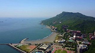
WShoushan is a mountain in Gushan District, Kaohsiung, Taiwan, north of the main entrance to Kaohsiung Harbor. It was named Ape Hill by the Dutch in the 17th century to describe many monkeys on this mountain. It is also called Chaishan (柴山) and includes the Snake Hill in its northern part, and Long Life Hill (壽山) – named by Japanese in 1911-1915 for the crown-prince Hirohito – in the southern part. In some old maps, the peak of the hill is called Saracen's Head. Now it is a nature park where biological diversity can be seen.
 W
WSizihwan is a community and sightseeing spot in Gushan District, Kaohsiung, Taiwan, named for the adjacent bay of the Taiwan Strait, also called Sizihwan.
 W
WThe Spratly Islands are a disputed archipelago in the South China Sea. Composed of islands, islets and cays and more than 100 reefs, sometimes grouped in submerged old atolls, the archipelago lies off the coasts of the Philippines, Malaysia, and southern Vietnam. Named after the 19th-century British whaling captain Richard Spratly who sighted Spratly Island in 1843, the islands contain less than 2 km2 of naturally occurring land area, which is spread over an area of more than 425,000 km2 (164,000 sq mi).
 W
WTaiping Island, also known as Itu Aba, and also known by various other names, is the largest of the naturally occurring Spratly Islands in the South China Sea. The island is elliptical in shape being 1.4 kilometres (0.87 mi) in length and 0.4 kilometres (0.25 mi) in width, with an area of 46 hectares. It is located on the northern edge of the Tizard Bank. The runway of the Taiping Island Airport is easily the most prominent feature on the island, running its entire length.
 W
WThe Tianliao Moon World is an area of badlands in Tianliao District, Kaohsiung, Taiwan.
 W
WXiangyang Mountain is a mountain in Kaohsiung, Taiwan with an elevation of 3,603 m (11,821 ft).
 W
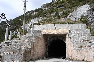
WYakou, also known as Guanshan Pass or Daguanshan Pass, is a mountain pass in Taiwan transversing the Central Mountain Range within Yushan National Park. The name Yakou literally means "mountain pass". At the peak, there is a short, one-way named the Daguanshan Tunnel, which is the highest tunnel in Taiwan. Administratively, it is located at the border of Taoyuan, Kaohsiung and Haiduan, Taitung.
 W
WThe Yushan Range, formerly the Niitaka Range and also known as the Jade Mountain Range, is a mountain range in the central-southern region of Taiwan Island. It spans Chiayi County, Kaohsiung City, and Nantou County. It faces the Central Mountain Range on the east, and is separated by the Qishan River from the Alishan Range which is on the west of the Yushan Range. The Yushan Range is one of the five major ranges on Taiwan.
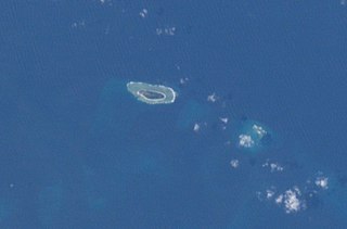
WZhongzhou Reef also known as Ban Than Reef and Centre Cay is a small coral reef on the north edge of the Tizard Bank in the Spratly Islands, South China Sea. It lies 4.6 km (2.9 mi) east of Taiwan-administered Taiping Island, 7.2 km (4.5 mi) west of Vietnam-administered Sand Cay, and has an exposed area of approximately 0.2 hectares during high tide, and 0.6 hectares during low tide. It consists of an accumulation of seashells, sand, coral reefs and debris which forms a circular coral reef plate, surrounding the reef under the water, with a diameter of approximately 1.3 km (0.8 mi).
 W
WThe Zhuokou River, also spelled Chokou River or Jhuokou River, is a tributary of the Laonong River, which in turn is a tributary of the Gaoping River, the main stream of this major river system in southwestern Taiwan. It flows through the Taoyuan and Maolin Districts of Kaohsiung City for 50 km.