 W
WBadwater Basin is an endorheic basin in Death Valley National Park, Death Valley, Inyo County, California, noted as the lowest point in North America and the United States, with a depth of 282 ft (86 m) below sea level. Mount Whitney, the highest point in the contiguous 48 United States, is only 84.6 miles (136 km) to the northwest.
 W
WBicycle Lake is a dry lake in the Mojave Desert of San Bernardino County, California, 60 km (37 mi) northeast of Barstow. The lake is approximately 4 km (2.5 mi) long and 3 km (1.9 mi) at its widest point.
 W
WBristol Lake is a dry lake in the Mojave Desert of San Bernardino County, California, 42 km (26 mi) northeast of Twentynine Palms.
 W
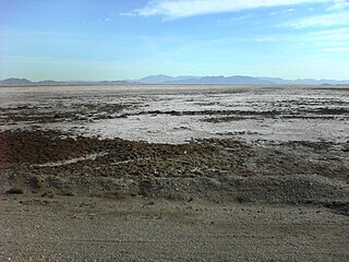
WBroadwell Lake, sometimes called Broadwell Dry Lake, is a dry lake bed in the Mojave Desert of San Bernardino County, California, 75 km (47 mi) east of Barstow. Flanked by the Cady Mountains and the Bristol Mountains, the lake is approximately 7 km (4.3 mi) long and 2 km (1.2 mi) at its widest point.
 W
WCoyote Dry Lake is a dry lake bed in the Mojave Desert of San Bernardino County, California, 15 mi (24 km) northeast of Barstow. The lake is approximately 10 km (6.2 mi) by 6 km (3.7 mi) at its widest point.
 W
WCuddeback Lake is a dry lake in the Mojave Desert of San Bernardino County, California, 60 km (37 mi) northeast of Edwards Air Force Base. The lake is approximately 10 km (6.2 mi) long and 4 km (2.5 mi) at its widest point.
WDanby Lake is a dry lake bed in the Mojave Desert of San Bernardino County, California, 50 mi (80 km) northwest of Blythe. The lake is approximately 9 mi (14 km) long and 2.5 mi (4.0 km) at its widest point.
 W
WDiaz Lake, elevation 3,674 feet (1,120 m), is located in the Owens Valley, just south of Lone Pine, California, United States. It covers 80 acres (32 ha).
 W
WEl Mirage Lake is a dry lake bed in the northwestern Victor Valley of the central Mojave Desert, within San Bernardino County, California.
WEmerson Lake is a dry lake bed in the Mojave Desert of San Bernardino County, California, 66 km (41 mi) northeast of Joshua Tree. The lake is approximately 6 km (3.7 mi) long and 4.5 km (2.8 mi) at its widest point.
WGoldstone Lake is a dry lake in the Mojave Desert of San Bernardino County, California, 56 km (35 mi) northeast of Barstow. The lake is approximately 5 km (3.1 mi) long and 3 km (1.9 mi) at its widest point.
 W
WHarper Lake is a dry lake located in the Mojave Desert near the small community of Lockhart, California, in northwestern San Bernardino County of Southern California. The lake is accessible from Harper Lake Road, which runs north off of State Route 58 midway between Boron and Barstow.
 W
WLake Havasu is a large reservoir formed by Parker Dam on the Colorado River, on the border between San Bernardino County, California and La Paz County, Arizona. Lake Havasu City sits on the Arizona (eastern) side of the lake with its Californian counterpart of Havasu Lake directly across the lake. The reservoir has an available capacity of 619,400 acre feet (764,000,000 m3). The concrete arch dam was built by the United States Bureau of Reclamation between 1934 and 1938. The lake's primary purpose is to store water for pumping into two aqueducts. Prior to the dam construction, the area was home to the Mojave Indians. The lake was named after the Mojave word for blue. In the early 19th century, it was frequented by beaver trappers. Spaniards also began to mine the areas along the river.
 W
WIvanpah Lake is a dry lake bed in the Mojave Desert of San Bernardino County, California on the border of California and Nevada. Nestled in the Ivanpah Valley near Primm on Interstate 15, the 13-square-mile (34 km2) lake is almost entirely within California. At the north edge of the lake lie the Nevada Welcome Center (closed) and a California Lottery retailer. It is a popular place for land sailing and kite buggying.
WKoehn Lake is a dry lake, and seasonally endorheic lake, in the Fremont Valley of the Mojave Desert, in eastern Kern County, California.
 W
WLake Tuendae is an artificial pond at the Desert Studies Center in Zzyzx, California. It is inhabited by introduced mudhens as well as the endangered Mohave tui chub.
WLucerne Lake is a dry lake bed in the Mojave Desert of San Bernardino County, California, 24 km (15 mi) east of Apple Valley. The lake is approximately 6 km (3.7 mi) long and 8 km (5.0 mi) at its widest point.
WLake Manix is a former lake fed by the Mojave River in the Mojave Desert. It lies within San Bernardino County, California. Located close to Barstow, this lake had the shape of a cloverleaf and covered four basins named Coyote, Cady/Manix, Troy and Afton. It covered a surface area of 236 square kilometres (91 sq mi) and reached an altitude of 543 metres (1,781 ft) at highstands, although poorly recognizable shorelines have been found at altitudes of 547–558 metres (1,795–1,831 ft). The lake was fed by increased runoff during the Pleistocene and overflowed into the Lake Mojave basin and from there to Lake Manly in Death Valley, or less likely into the Bristol Lake basin and from there to the Colorado River.
 W
WLake Manly was a pluvial lake in Death Valley, California, covering much of Death Valley with a surface area of 1,600 square kilometres (620 sq mi) during the so-called "Blackwelder stand". Water levels varied through its history, and the chronology is further complicated by active tectonic processes that have modified the elevations of the various shorelines of Lake Manly; during the Blackwelder stage they reached 47–90 metres (154–295 ft) above sea level. The lake received water mainly from the Amargosa River and at various points from the Mojave River and Owens River. The lake and its substantial catchment favoured the spread of a number of aquatic species, including some lizards, pupfish and springsnails. The lake probably supported a substantial ecosystem, and a number of diatoms developed there.
 W
WLake Mead is a man-made lake that lies on the Colorado River, about 24 mi (39 km) from the Las Vegas Strip, southeast of the city of Las Vegas, Nevada, in the states of Nevada and Arizona. It is the largest reservoir in the United States in terms of water capacity. Formed by the Hoover Dam on September 30, 1935, the reservoir serves water to the states of Arizona, California, and Nevada, as well as some of Mexico, providing sustenance to nearly 20 million people and large areas of farmland.
 W
WLake Mohave is a reservoir on the Colorado River between the Hoover Dam and Davis Dam in Cottonwood Valley defining the border between Nevada and Arizona in the United States. This 67 mile stretch of the Colorado River flows past Boulder City, Nelson, Searchlight, Cottonwood Cove, Cal-Nev-Ari, and Laughlin to the west in Nevada and Willow Beach and Bullhead City to the east in Arizona. A maximum width of 4 miles wide and an elevation of 647 feet (197 m), Lake Mohave encompasses 28,260 acres of water. As Lake Mead lies to the north of the Hoover Dam, Lake Mohave and adjacent lands forming its shoreline are part of the Lake Mead National Recreation Area administered by the U.S. National Park Service.
WLake Mojave is an ancient former lake fed by the Mojave River that, through the Holocene, occupied the Silver Lake and Soda Lake basins in the Mojave Desert of San Bernardino County, California. Its outlet may have ultimately emptied into the Colorado River north of Blythe.
WNelson Lake is a dry lake in the Mojave Desert of San Bernardino County, California, 67 km (42 mi) northeast of Barstow. The lake is approximately 3 km (1.9 mi) by 2 km (1.2 mi) at its widest point.
 W
WOwens Lake is a mostly dry lake in the Owens Valley on the eastern side of the Sierra Nevada in Inyo County, California. It is about 5 miles (8.0 km) south of Lone Pine, California. Unlike most dry lakes in the Basin and Range Province that have been dry for thousands of years, Owens held significant water until 1913, when much of the Owens River was diverted into the Los Angeles Aqueduct, causing Owens Lake to desiccate by 1926. Today, some of the flow of the river has been restored, and the lake now contains some water. Nevertheless, as of 2013, it is the largest single source of dust pollution in the United States. The lake was the epicenter of a magnitude 5.8 earthquake that happened on June 24, 2020
WRed Pass Lake is a dry lake bed in the Mojave Desert of San Bernardino County, California, 66 km (41 mi) northeast of Tecopa. The lake is approximately 3 km (1.9 mi) long and 2.5 km (1.6 mi) at its widest point.
 W
WRogers Dry Lake is an endorheic desert salt pan in the Mojave Desert of Kern County, California. The lake derives its name from the Anglicization from the Spanish name, Rodriguez Dry Lake. It is the central part of Edwards Air Force Base as its hard surface provides a natural extension to the paved runways. It was formerly known as Muroc Dry Lake.
 W
WRosamond Lake is a natural dry lake bed in the Mojave Desert of Kern- and Los Angeles County, California. The shores of the lake are entirely within the borders of Edwards Air Force Base, approximately 10 miles (16 km) from Lancaster. The lake is adjacent to Rogers Dry Lake which through the Holocene, together made up one large water-body. Piute Ponds are immediately to the southwest.
 W
WSearles Lake is an endorheic dry lake in the Searles Valley of the Mojave Desert, in northwestern San Bernardino County, California. The lake in the past as also be called Slate Range Lake and Borax Lake.
 W
WSilver Lake is a dry lake bed in the Mojave Desert of San Bernardino County, California, along Interstate 15, 100 km (62 mi) northeast of Barstow.
 W
WSoda Lake is a dry lake at the terminus of the Mojave River in the Mojave Desert of San Bernardino County, California. The lake has standing water during wet periods, and water can be found beneath the surface.
WSuperior Lake is a dry lake basin in the Mojave Desert of San Bernardino County, California, 40 km (25 mi) north of Barstow. The lake is made up of three basins, approximately 15 km (9.3 mi) long and 6 km (3.7 mi) at its widest point. Through the Holocene, this three-lake system was one body of water.