 W
WThis is a list of Irish counties by their highest point. These are most commonly known as county high points but are also sometimes referred to as county tops and county peaks. There are 32 counties in Ireland, but in the case of 10 counties, marked with (‡), the highest point is shared between two counties, so there are only 27 distinct Irish county high points. This list is generated from the Irish MountainViews Online Database, and the overall ranking of an Irish County High Point against all other peaks in Ireland, is based on the Vandeleur-Lynam definition where a peak must have a minimum topographic prominence of 15 metres (49 ft) to be on the list of peaks in Ireland. The four Irish provincial tops, more also referred to as province high points, are also listed. The listings of Irish county high points under the definitions of Irish mountains, are also provided.
 W
WThis is a list of the six traditional counties of Northern Ireland by their highest point.
 W
WThis is a list of the eleven current districts of Northern Ireland by their highest point.
 W
WArderin is a mountain on the border between Laois and Offaly in Ireland. With a height of 527 metres (1,729 ft) it is the highest point in the Slieve Bloom Mountains, and is both the highest point in County Laois and County Offaly.
 W
WBenbaun at 729 metres (2,392 ft), is the 72nd–highest peak in Ireland on the Arderin scale, and the 88th–highest peak on the Vandeleur-Lynam scale. Benbaun is situated at the centre of the core massif of the Twelve Bens mountain range in the Connemara National Park in Galway, Ireland, and is the tallest mountain of the Twelve Bens range, and the county top for Galway.
 W
WBrandon Hill is the highest mountain in County Kilkenny, Ireland, with an elevation of 515 m (1,690 ft) and prominence at 448 m (1,470 ft). The South Leinster Way, a long-distance trail, meandering through the Barrow Valley and traverses Brandon Hill. The village of Graiguenamanagh and River Barrow are at the base of the hill. It is classified as a county high point, an Arderin, a Myrddyn Dewey, and a Marilyn.
 W
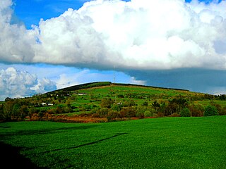
WCorn Hill, also called Carn Hill or Carn Clonhugh, is a hill in County Longford, Republic of Ireland. It lies north of Longford, between Drumlish and Ballinalee, in the parish of Killoe. At 278 metres above sea level, it is the highest hill in the county and has a television mast on the top which rises 123 metres above the peak of the hill.
 W
WCarrauntoohil or Carrauntoohill is the highest mountain on the island of Ireland at 1,038.6 metres. It is on the Iveragh Peninsula in the Reeks District in County Kerry, close to the centre of Ireland's highest mountain range, MacGillycuddy's Reeks. Carrauntoohil is composed mainly of sandstone, whose glaciation produced distinctive features on the mountain such as the Eagle's Nest corrie and some deep gullies and sharp arêtes in its east and northeastern faces that are popular with rock and winter climbers.
 W
WCuilcagh is a mountain on the border between County Fermanagh and County Cavan. With a height of 665 metres (2,182 ft) it is the highest point in both counties. It is also the 170th highest peak on the island of Ireland, and Ireland's only cross-border county top. Water from the southern slope flows underground until it emerges some miles away in the Shannon Pot, the traditional source of the River Shannon. The area is sometimes referred to as the Cuilcagh Mountains.
 W
WCupidstown Hill, at 379 metres (1,243 ft), is the highest point in County Kildare, Ireland, and lies on the fringes of the Wicklow Mountains, 11.6 kilometres (7.2 mi) east of Naas.
 W
WErrigal is a 751-metre (2,464 ft) mountain near Gweedore in County Donegal, Ireland. It is the tallest peak of the Derryveagh Mountains and the tallest peak in County Donegal.
 W
WGaltymore or Galteemore, at 917.9 metres (3,011 ft), is one of Ireland's highest mountains being the 12th-highest peak in Ireland on the Arderin list, and the 14th-highest peak on the Vandeleur-Lynam list. Galtymore has the 4th-highest topographic prominence of any peak in Ireland, which classifies Galtymore as a P600, or "major mountain". It is also one of the 13 Irish Munros.
 W
WGarraun at 598 metres (1,962 ft), is the 224th–highest peak in Ireland on the Arderin scale, however, while it is just short of the elevation threshold of 600-metres for other classifications, it does have the prominence to be a Marilyn. Garraun lies on an isolated massif near the mouth of Killary Harbour at the far north sector of the Twelve Bens/Garraun Complex Special Area of Conservation in the Connemara National Park in Galway. The southern slopes are a scenic backdrop to Kylemore Abbey and Kylemore Lough.
 W
WSlieve Gullion is a mountain in the south of County Armagh, Northern Ireland. The mountain is the heart of the Ring of Gullion and is the highest point in the county, with an elevation of 573 metres (1,880 ft). At the summit is a small lake and two ancient burial cairns, one of which is the highest surviving passage grave in Ireland. Slieve Gullion appears in Irish mythology, where it is associated with the Cailleach and the heroes Fionn mac Cumhaill and Cú Chulainn. It dominates the countryside around it, offering views as far away as Antrim, Dublin Bay and Wicklow on a clear day. Slieve Gullion Forest Park is on its eastern slope.
 W
WKippure at 757 metres (2,484 ft), is the 56th-highest peak in Ireland on the Arderin scale, and the 72nd-highest peak on the Vandeleur-Lynam scale. Kippure is situated in the far northern sector of the Wicklow Mountains, where it lies on the border of the counties of Dublin and Wicklow in Ireland. Kippure is the County Top for Dublin, and its height and positioning over Dublin city have made its summit an important site for transmission masts, which are highly visible from a distance. Kippure's slopes feed into the Liffey Head Bog which forms the source of the River Liffey. The summit can be easily accessed from the east via a path that lies off the R115 road along the route to the Sally Gap.
 W
WKnockboy is a 706-metre-high mountain on the border between counties Cork and Kerry in Ireland.
 W
WKnockmealdown is the highest peak of the Knockmealdown Range of mountains, located on the border between Co Tipperary and Co Waterford.
 W
WLugnaquilla, at 925 metres (3,035 ft), is the 11th–highest peak in Ireland on the Arderin list, and 13th–highest on the Vandeleur-Lynam list, and the highest Irish mountain outside of Kerry. Lugnaquilla is the highest point in Wicklow, and in the province of Leinster. Lugnaquilla is in the Wicklow Mountains, and overlooks the Glen of Imaal to the west and Glenmalure to the east.
 W
WMacGillycuddy's Reeks is a sandstone and siltstone mountain range in the Iveragh Peninsula in County Kerry, Ireland. Stretching 19 kilometres, from the Gap of Dunloe in the east, to Glencar in the west, the Reeks is Ireland's highest mountain range, and includes most of the highest peaks and sharpest ridges in Ireland, and the only peaks on the island over 1,000 metres in height.
 W
WMount Leinster is a 794-metre-high (2,605 ft) mountain in the Republic of Ireland. It straddles the border between Counties Carlow and Wexford, in the province of Leinster. It is the fifth-highest mountain in Leinster after Lugnaquilla 925 metres (3,035 ft), Mullaghcleevaun 849 metres (2,785 ft), Tonelagee 817 metres (2,680 ft), and Cloghernagh 800 metres (2,600 ft), and the highest of the Blackstairs Mountains. A 2RN transmission site tops the peak with a mast height of 122 metres (400 ft).
 W
WMoylussa is a mountain in the Slieve Bernagh range in western Ireland, and the highest point in County Clare at 532 metres (1,745 ft).
 W
WMullaghmeen, at 258 metres (846 ft), is the county top for Westmeath in Ireland, and is the lowest county top in Ireland. Mullaghmeen is located in the Mullaghmeen Forest, known for having the largest planted beech forest in Europe.
 W
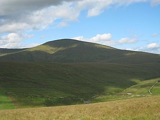
WSawel Mountain is the highest peak in the Sperrin Mountains, and the 8th highest in Northern Ireland. It is also the highest mountain in Northern Ireland outside of the Mourne Mountain range located in County Down.
 W
WSeltannasaggart, also called Corry Mountain, is a low mountain near Lough Allen on the border of County Roscommon and County Leitrim in Ireland; it is the highest point in Roscommon.
 W
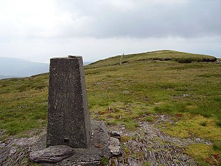
WSlieve Beagh or Sliabh Beagh is a mountainous area straddling the border between County Monaghan in the Republic of Ireland and County Fermanagh and County Tyrone in Northern Ireland. A point just east of its summit is the highest point in Monaghan; however the true summit is on the Fermanagh-Tyrone border. The point where the three counties meet, is referred to as the "Three County Hollow".
 W
WSlieve Donard is the highest mountain in Northern Ireland and the wider province of Ulster, with a height of 850 metres (2,790 ft). The highest of the Mourne Mountains, it is near the town of Newcastle on the eastern coast of County Down, overlooking the Irish Sea. It is also the highest mountain in the northern half of Ireland, and 7th highest on the island.
 W
WSlieve Foy or Slieve Foye is a mountain on the Cooley Peninsula in Louth, Ireland. It rises to 589 metres (1,932 ft), making it the highest of the Cooley Mountains and the highest in Louth. It overlooks Carlingford Lough and the village of Carlingford, and is sometimes called Carlingford Mountain.
 W
WSlieve na Calliagh is a range of hills and archaeological site near Oldcastle, County Meath, Ireland. The summit is 276 metres (906 ft), the highest point in the county, and an important site for megalithic tombs.
 W
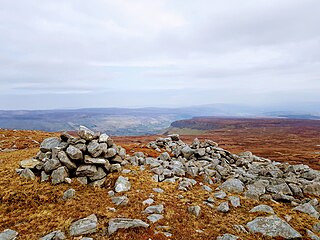
WTrostan is a mountain in County Antrim, Northern Ireland and at 551 metres is the highest point in the county.
 W
WTruskmore is a 647 m (2,123 ft) mountain on the border of County Sligo and County Leitrim in Ireland. It is the highest peak of the Dartry Mountains and the highest in Sligo. Truskmore is the highest point on a plateau stretching across northeast Sligo and northwest Leitrim. The edges of this plateau are marked by high cliffs, including Ben Bulbin (526m), Benwiskin (514m), Slievemore (597m) and Kings Mountain (462m). The peak of Truskmore lies in County Sligo, a short distance from the border with County Leitrim; however, the mountain itself is within both counties.
 W
WTruskmore South-East Cairn is the highest point in Leitrim at 631 m (2,070 ft) above sea level. It is part of Truskmore mountain and is located approximately 450 metres southeast of the mountain's summit, which is 16 m (52 ft) higher and located in County Sligo.