 W
WJoadja is a historic town, now in ruins, in the Southern Highlands of New South Wales, Australia, in Wingecarribee Shire. The remnants of the town were added to the New South Wales State Heritage Register on 5 November 1999.
 W
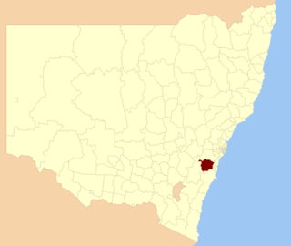
WWingecarribee Shire is the local government area of the Southern Highlands in the state of New South Wales, Australia. The Wingecarribee Shire is around 110 kilometres (70 mi) southwest of the Sydney central business district and is part of regional Capital Country and to some extent can be considered part of the Southern Tablelands.
 W
WThe Avon Dam is a heritage-listed dam in Avon, Wingecarribee Shire, New South Wales, Australia. It is one of four dams and weirs in the catchment of the Upper Nepean Scheme, providing water to the Macarthur and Illawarra regions, the Wollondilly Shire, and metropolitan Sydney. The arch dam across the Avon River was completed in 1927 under the supervision of Ernest Macartney de Burgh, the dam is currently managed by the Sydney Catchment Authority and is listed on the New South Wales State Heritage Register.
 W
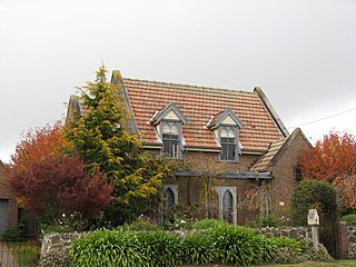
WBerrima is a historic village in the Southern Highlands of New South Wales, Australia, in Wingecarribee Shire. The village, once a major town, is located on the Old Hume Highway between Canberra and Sydney. It was previously known officially as the Town of Berrima. It is close to the three major towns of the Southern Highlands; Mittagong, Bowral and Moss Vale.
 W
WBundanoon railway station is a heritage-listed railway station on the Main South line in New South Wales, Australia. It serves the small town of Bundanoon. It was added to the New South Wales State Heritage Register on 2 April 1999.
 W
WBundanoon is a town in the Southern Highlands of New South Wales, Australia, in Wingecarribee Shire. At the 2016 census, Bundanoon had a population of 2,729. It is an Aboriginal name meaning "place of deep gullies" and was formerly known as Jordan's Crossing. Bundanoon is colloquially known as Bundy/Bundi.
 W
WChrist Church is a heritage-listed Anglican church located on Bong Bong Road, Bong Bong, in the Wingecarribee Shire local government area of New South Wales, Australia. It was built in 1845 at the behest of Charles Throsby, possibly by convict labour. The design of the church has been attributed to John Verge. The church site includes an associated cemetery. It was added to the New South Wales State Heritage Register on 7 April 2000.
 W
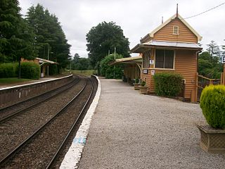
WExeter railway station is a heritage-listed railway station on the Main South line in New South Wales, Australia. It serves the village of Exeter. It was added to the New South Wales State Heritage Register on 2 April 1999.
 W
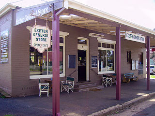
WExeter is a village in the Southern Highlands district of New South Wales, Australia, in Wingecarribee Shire. It has a station on the Main Southern railway line south of Sydney. At the 2016 census, Exeter had a population of 949.
 W
WManchester Square is a locality in the Southern Highlands of New South Wales, Australia, in Wingecarribee Shire.
WMedway is a village in the Southern Highlands of New South Wales, Australia, in Wingecarribee Shire. It was formerly known as Village of Medway.
 W
WMittagong is a town located in the Southern Highlands of New South Wales, Australia, in Wingecarribee Shire. The town acts as the gateway to the Southern Highlands when coming from Sydney. Mittagong is situated at an elevation of 635 metres (2,083 ft). The town is close to Bowral, Berrima, Moss Vale and the Northern Villages such as Yerrinbool and Colo Vale. Moreover, Mittagong is home to many wineries of the Southern Highlands which has been a recent growing wine and cellar door region.
WMount Murray is a mountain in New South Wales, Australia with an elevation of 780 metres above sea level. It is located six kilometres outside Robertson. The mountain is named after Sir George Murray. Mount Murray is also the name of a location at the top of the Macquarie Pass on the Illawarra Highway. At the 2016 census, it had a population of 54.
 W
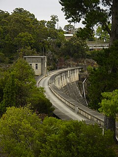
WThe Nepean Dam is a heritage-listed dam split across Avon in the Wingecarribee Shire and Bargo in the Wollondilly Shire, both in New South Wales, Australia. The reservoir created by the dam spreads across Avon, Bargo and also Yerrinbool in Wingecarribee Shire. The Nepean Dam is one of four dams and weirs in the catchment of the Upper Nepean Scheme, in New South Wales, Australia, and provides water to the Macarthur and Illawarra regions, the Wollondilly Shire, and metropolitan Sydney. Completed in 1935 under the supervision of Ernest Macartney de Burgh, the dam is currently managed by the Sydney Catchment Authority and is listed on the New South Wales State Heritage Register.
WNew Berrima is a village in the Southern Highlands of New South Wales, Australia, in Wingecarribee Shire. At the 2016 census, New Berrima had a population of 584.
WPaddys River is a locality in the Southern Highlands of New South Wales, Australia, in Wingecarribee Shire. The locality was previously known as Murrimba. It is south of Canyonleigh.
WPenrose is a small town in the Southern Highlands of New South Wales, Australia, in Wingecarribee Shire. It has a station on the Main Southern railway line served by NSW TrainLink's Southern Highlands Line. At the 2016 census, Penrose had a population of 247.
 W
WRobertson is a village in the Southern Highlands of New South Wales, Australia, in Wingecarribee Shire. The town is located on the edge of an elevated plateau about 35 km (22 mi) from the coast. At the 2016 census, Robertson and its surrounding area had a population of 1,865.
WSutton Forest is a small village in the Southern Highlands, New South Wales, Australia in Wingecarribee Shire. It is located 5 km southwest of Moss Vale on the Illawarra Highway. Sutton Forest was originally granted, then owned by Navy Chief officer, Captain John Nicholson who recently immigrated from Scotland to Australia. This privately owned estate was originally 700 acres, this is where John Nicholson lived and died.
WWattle Ridge is a locality in the Southern Highlands of New South Wales, Australia, in Wingecarribee Shire. It is located near Buxton and Balmoral. At the 2016 census, it had a population of 4.
WWelby is a small town in the Southern Highlands of New South Wales, Australia, in Wingecarribee Shire. It was originally called Fitz Roy. The town is located 1 km west of Mittagong and houses the local Southern Highlands RTA office. At the 2016 census, Welby had a population of 759.
WWerai is a locality in the Southern Highlands of New South Wales, Australia, in Wingecarribee Shire. At the 2016 census, Werai had a population of 90.
WWildes Meadow is a locality in the Southern Highlands of New South Wales, Australia, in Wingecarribee Shire. At the 2016 census, it had a population of 259.
WWillow Vale is a Northern Village of the Southern Highlands of New South Wales, Australia, in Wingecarribee Shire. It is located 1 km north of Mittagong and is often considered part of Braemar along with its neighbour Balaclava. At the 2016 census, Willow Vale had a population of 717.
 W
WWingecarribee Swamp is a heritage-listed wetland at Illawarra Highway, Robertson, Wingecarribee Shire, New South Wales, Australia. It was added to the New South Wales State Heritage Register on 2 April 1999. It is also listed on the Directory of Important Wetlands in Australia and the former Register of the National Estate.
 W
WWingello railway station is a heritage-listed railway station on the Main South line in New South Wales, Australia. It serves the village of Wingello. It was added to the New South Wales State Heritage Register on 2 April 1999.
 W
WWingello is a village in the Southern Highlands of New South Wales, Australia. It has a station on NSW TrainLink's Southern Highlands Line. The surrounding area is part of the lands administrative unit of the Wingello Parish.
WWoodlands is a small village situated at the T-intersection of Wombeyan Caves Road and Spring Hill Road in the Southern Highlands of New South Wales, Australia, in Wingecarribee Shire. At the 2016 census, Woodlands had a population of 272.
 W
WYerrinbool railway station is located on the Main South line in New South Wales, Australia. It serves the town of Yerrinbool, opening on 13 July 1919 at the same time as a new alignment between Picton and Mittagong. In March 1991, the weatherboard building on Platform 1 was demolished.
WYerrinbool is a Northern Village of the Southern Highlands of New South Wales, Australia, in the Wingecarribee Shire, and is accessible from the Hume Highway and is about a 12 km (7.5 mi) drive from nearby Mittagong. It is 7 km (4.3 mi) to Hill Top as the crow flies, accessible by foot via a fire trail. It is on the western edge of the Upper Nepean Nature Reserve, a vast area of forest, lakes and dams between Yerrinbool and the coastal communities around Wollongong. Yerrinbool was previously officially known as the Town of Yerrinbool. It is located on the historic Old Hume Highway. At the 2016 census, Yerrinbool had a population of 1,164.