 W
WThe Agulhas Current is the western boundary current of the southwest Indian Ocean. It flows south along the east coast of Africa from 27°S to 40°S. It is narrow, swift and strong. It is suggested that it is the largest western boundary current in the world ocean, with an estimated net transport of 70 sverdrups, as western boundary currents at comparable latitudes transport less — Brazil Current, Gulf Stream, Kuroshio.
 W
WThe Andaman Sea is a marginal sea of northeastern Indian Ocean bounded by the coastlines of Myanmar and Thailand along the Gulf of Martaban and west side of the Malay Peninsula, and separated from the Bay of Bengal to its west by the Andaman Islands and the Nicobar Islands. Its southernmost end is defined by Breueh Island, an island just north of Sumatra, and communicates with the Malacca Strait.
 W
WThe Arabian Sea is a region of the northern Indian Ocean bounded on the north by Pakistan, Iran, and the Gulf of Oman, on the west by the Gulf of Aden, Guardafui Channel and the Arabian Peninsula, on the southeast by the Laccadive Sea, on the southwest by the Somali Sea, and on the east by India. Its total area is 3,862,000 km2 (1,491,000 sq mi) and its maximum depth is 4,652 meters (15,262 ft). The Gulf of Aden in the west connects the Arabian Sea to the Red Sea through the strait of Bab-el-Mandeb, and the Gulf of Oman is in the northwest, connecting it to the Persian Gulf.
 W
WThe Banda Sea is a sea in the Maluku Islands of Indonesia, connected to the Pacific Ocean but surrounded by hundreds of islands, as well as the Halmahera and Ceram Seas. It is about 1000 km (600 mi) east to west, and about 500 km (300 mi) north to south.
 W
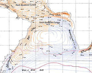
WThe Benguela Current is the broad, northward flowing ocean current that forms the eastern portion of the South Atlantic Ocean gyre. The current extends from roughly Cape Point in the south, to the position of the Angola-Benguela front in the north, at around 16°S. The current is driven by the prevailing south easterly trade winds. Inshore of the Benguela Current proper, the south easterly winds drive coastal upwelling, forming the Benguela Upwelling System. The cold, nutrient rich waters that upwell from around 200–300 m depth in turn fuel high rates of phytoplankton growth, and sustain the productive Benguela ecosystem.
 W
WThe Bering Sea is a marginal sea of the Northern Pacific Ocean. It forms, along with the Bering Strait, the divide between the two largest landmasses on Earth: Eurasia and The Americas. It comprises a deep water basin, which then rises through a narrow slope into the shallower water above the continental shelves. The Bering Sea is named for Vitus Bering, a Danish navigator in Russian service, who, in 1728, was the first European to systematically explore it, sailing from the Pacific Ocean northward to the Arctic Ocean.
 W
WThe Canary Current is a wind-driven surface current that is part of the North Atlantic Gyre. This eastern boundary current branches south from the North Atlantic Current and flows southwest about as far as Senegal where it turns west and later joins the Atlantic North Equatorial Current. The current is named after the Canary Islands. The archipelago partially blocks the flow of the Canary Current.
 W
WThe Chesapeake Bay is the largest estuary in the United States. The Bay is located in the Mid-Atlantic region and is primarily separated from the Atlantic Ocean by the Delmarva Peninsula with its mouth of the Bay at the south end located between Cape Henry and Cape Charles. With its northern portion in Maryland and the southern part in Virginia, the Chesapeake Bay is a very important feature for the ecology and economy of those two states, as well as others surrounding within its watershed. More than 150 major rivers and streams flow into the Bay's 64,299-square-mile (166,534 km2) drainage basin, which covers parts of six states and all of Washington, D.C. / District of Columbia.
 W
WCocos Island is an island in the Pacific Ocean administered by Costa Rica, approximately 550 km southwest of the Costa Rican mainland. It constitutes the 11th of the 13 districts of Puntarenas Canton of the Province of Puntarenas. With an area of approximately 23.85 km2 (9.21 sq mi), the island is more or less rectangular in shape. It is the southernmost point on the North American continent if outer islands are included.
 W
WThe Coral Triangle (CT) is a roughly triangular area of the tropical marine waters of Indonesia, Malaysia, Papua New Guinea, Philippines, Solomon Islands and Timor-Leste that contain at least 500 species of reef-building corals in each ecoregion. CT located in equator, between Pacific and Indian Ocean that encompasses portions of two biogeographic regions: the Indonesian-Philippines Region, and the Far Southwestern Pacific Region. As part of eight major coral reef reef zone in the world, CT is recognized as the global centre of marine biodiversity and a global priority for conservation. It is also called the "Amazon of the seas" and covers 5.7 million square kilometres (2,200,000 sq mi) of ocean waters. Its biological resources categorize as a global hotspot of marine biodiversity that contains >76% of the world's shallow-water reef-building coral species, 37% of the world's reef fishes, 50% of razor clams, six out of seven of the world's sea turtles, and the largest mangrove forest in the world. In 2014, the Asian Development Bank (ADB) reported a gross domestic product of the marine ecosystem in CT reaches $1.2 trillion per year for over 120 million people. According to the Coral Triangle Knowledge Network, about $3 billion in fisheries exports and another $3 billion in coastal tourism revenues are derived as annual foreign exchange income in the region.
 W
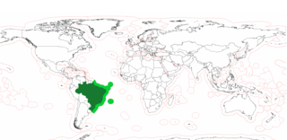
WThe Blue Amazon or Brazilian maritime territory is the exclusive economic zone (EEZ) of Brazil. It is an offshore area of 3.6 million square km on the Brazilian coast, rich in marine biodiversity and energy resources. The size is equivalent to the surface of the Amazon rainforest. The name is a reference to the biologically rich region of the Brazilian Amazon, with the addition of the adjective blue denoting the ocean.
 W
WThe Grand Banks of Newfoundland are a series of underwater plateaus south-east of the island of Newfoundland on the North American continental shelf. The Grand Banks are one of the world's richest fishing grounds, supporting Atlantic cod, swordfish, haddock and capelin, as well as shellfish, seabirds and sea mammals.
 W
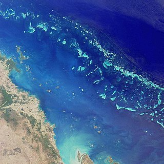
WThe Great Barrier Reef is the world's largest coral reef system composed of over 2,900 individual reefs and 900 islands stretching for over 2,300 kilometres (1,400 mi) over an area of approximately 344,400 square kilometres (133,000 sq mi). The reef is located in the Coral Sea, off the coast of Queensland, Australia. The Great Barrier Reef can be seen from outer space and is the world's biggest single structure made by living organisms. This reef structure is composed of and built by billions of tiny organisms, known as coral polyps. It supports a wide diversity of life and was selected as a World Heritage Site in 1981. CNN labelled it one of the seven natural wonders of the world. The Queensland National Trust named it a state icon of Queensland.
 W
WThe Hudson Complex is a marine ecoregion in Canada, part of the Arctic marine realm.
 W
WThe Humboldt Current, also called the Peru Current, is a cold, low-salinity ocean current that flows north along the western coast of South America. It is an eastern boundary current flowing in the direction of the equator, and extends 500–1,000 km (310–620 mi) offshore. The Humboldt Current is named after the Prussian naturalist Alexander von Humboldt. In 1846, von Humboldt reported measurements of the cold-water current in his book Cosmos.
 W
WThe marine ecoregions of the South African exclusive economic zone are a set of geographically delineated regions of similar ecological characteristics on a fairly broad scale, covering the exclusive economic zone along the South African coast.
 W
WThe Mediterranean Sea is a sea connected to the Atlantic Ocean, surrounded by the Mediterranean Basin and almost completely enclosed by land: on the north by Southern Europe and Anatolia, on the south by North Africa, and on the east by the Levant. Although the sea is sometimes considered a part of the Atlantic Ocean, it is usually referred to as a separate body of water. Geological evidence indicates that around 5.9 million years ago, the Mediterranean was cut off from the Atlantic and was partly or completely desiccated over a period of some 600,000 years during the Messinian salinity crisis before being refilled by the Zanclean flood about 5.3 million years ago.
 W
WThe Mesoamerican Barrier Reef System (MBRS), also popularly known as the Great Mayan Reef or Great Maya Reef, is a marine region that stretches over 1,126 kilometres (700 mi) along the coasts of four countries – Mexico, Belize, Guatemala, and Honduras – from Isla Contoy at the northern tip of the Yucatán Peninsula south to Belize, Guatemala and the Bay Islands of Honduras. The reef system includes various protected areas and parks including the Belize Barrier Reef, Arrecifes de Cozumel National Park, Hol Chan Marine Reserve (Belize), Sian Ka'an biosphere reserve, and the Cayos Cochinos Marine Park. Belize's coastline, including the Belize Barrier Reef, is home to approximately 30% of the Mesoamerican Barrier Reef System.
 W
WThe New Caledonian barrier reef is located in New Caledonia in the South Pacific, and is the longest continuous barrier reef in the world and the third largest after the Great Barrier Reef of Australia and the Mesoamerican Barrier Reef.
 W
WThe North American Pacific Fjordland, also known as the Great Bear Fjordland, is a marine ecoregion off the western coast of North America, part of the Temperate Northern Pacific marine realm. It contains over 20,000 miles (32,000 km) of coastline extending along the continental shelf from Glacier Bay to Queen Charlotte Sound, and extends 200 miles into the Pacific Ocean. It borders the Gulf of Alaska to the north, the Salish Sea to the southeast, and the Oregon, Washington, Vancouver coast and shelf to the south.
 W
WThe Red Sea is a seawater inlet of the Indian Ocean, lying between Africa and Asia. Its connection to the ocean is in the south, through the Bab el Mandeb strait and the Gulf of Aden. To its north lie the Sinai Peninsula, the Gulf of Aqaba, and the Gulf of Suez. It is underlain by the Red Sea Rift, which is part of the Great Rift Valley.
 W
WThe Ryukyu Islands , also known as the Nansei Islands or the Ryukyu Arc , are a chain of Japanese islands that stretch southwest from Kyushu to Taiwan: the Ōsumi, Tokara, Amami, Okinawa, and Sakishima Islands, with Yonaguni the westernmost. The larger are mostly high islands and the smaller mostly coral. The largest is Okinawa Island.
 W
WThe Satsunan Islands is a geopolitical name for a group of islands that forms the northern part of the Ryukyu Islands. The whole island group belongs to Kagoshima Prefecture, Japan.
 W
WThe Saya de Malha Bank is the largest submerged ocean bank in the world, part of the vast undersea Mascarene Plateau.
 W
WSea Ice Microbial Communities (SIMCO) refer to groups of microorganisms living within and at the interfaces of sea ice at the poles. The ice matrix they inhabit has strong vertical gradients of salinity, light, temperature and nutrients. Sea ice chemistry is most influenced by the salinity of the brine which affects the pH and the concentration of dissolved nutrients and gases. The brine formed during the melting sea ice creates pores and channels in the sea ice in which these microbes can live. As a result of these gradients and dynamic conditions, a higher abundance of microbes are found in the lower layer of the ice, although some are found in the middle and upper layers. Despite this extreme variability in environmental conditions, the taxonomical community composition tends to remain consistent throughout the year, until the ice melts.
 W
WThe Sea of Japan (see below for other names) is the marginal sea between the Japanese archipelago, Sakhalin, the Korean Peninsula, and the Russian mainland. The Japanese archipelago separates the sea from the Pacific Ocean. Like the Mediterranean Sea, it has almost no tides due to its nearly complete enclosure from the Pacific Ocean. This isolation also affects faunal diversity and salinity, both of which are lower than in the open ocean. The sea has no large islands, bays or capes. Its water balance is mostly determined by the inflow and outflow through the straits connecting it to the neighboring seas and the Pacific Ocean. Few rivers discharge into the sea and their total contribution to the water exchange is within 1%.
 W
WThe Somali Current is a cold ocean boundary current that runs along the coast of Somalia and Oman in the Western Indian Ocean and is analogous to the Gulf Stream in the Atlantic Ocean. This current is heavily influenced by the monsoons and is the only major upwelling system that occurs on a western boundary of an ocean. The water that is upwelled by the current merges with another upwelling system, creating one of the most productive ecosystems in the ocean.
 W
WSoutheast Asian coral reefs have the highest levels of biodiversity for the world's marine ecosystems. They serve many functions, such as forming the livelihood for subsistence fishermen and even function as jewelry and construction materials. Coral reefs are developed by the carbonate-based skeletons of a variety of animals and algae. Slowly and overtime, the reefs build up to the surface in oceans. Coral reefs are found in shallow, warm salt water. The sunlight filters through clear water and allows microscopic organisms to live and reproduce. The Indian Ocean holds 60% of the world's coastal reefs, 25% are in the Pacific and 15% are in the western Atlantic. There are coral reefs in the Persian Gulf, Madagascar, the Philippines, Hawaiian Islands and off Southeast Asia. Coral reefs have been preserved and identified in rocks over 400 million years old. Coral reefs are actually composed of tiny, fragile animals known as coral polyps. Coral reefs are significantly important because of the biodiversity. Although the number of fish are decreasing, the remaining coral reefs contain more unique sea creatures. The variety of species living on a coral reef is greater than anywhere else in the world. An estimation of 70-90% of fish caught are dependent on coral reefs in Southeast Asia and reefs support over 25% of all known marine species. However, those sensitive coral reefs are facing detrimental effects on them due to variety of factors: overfishing, sedimentation and pollution, bleaching, and even tourist-related damage.
 W
WThe Southern California Bight is a 426 miles (685 km) long stretch of curved coastline of along the west coast of the United States and Mexico, from Point Conception in California to Punta Colonet in Baja California, plus the area of the Pacific Ocean defined by that curve. This includes the Channel Islands of California and the Coronado Islands and Islas de Todo Santos of Baja California.
 W
WThe Yellow Sea is a marginal sea of the Western Pacific Ocean located between mainland China and the Korean Peninsula, and can be considered the northwestern part of the East China Sea. It is one of four seas named after common colour terms, and its name is descriptive of the phenomenon whereby fine sand grains from the Gobi Desert sand storms, that descend annually from the north, turn the surface of its waters a golden yellow.