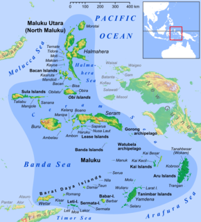
 W
WAmbon Bay is a bay that located in Ambon island, Maluku province, Indonesia. The bay separates Ambon island into two peninsulas; the southeastern and smaller peninsula is called Leitimur, while the larger northern peninsula is called Leihitu or Hitoe. These peninsulas are connected by a narrow neck of land on the eastern part of the island. The bay opens to the Banda Sea in the southwest direction. The Ambon Bay thus formed cuts about 20 kilometres into the island with the airport on the northern shore and the city of Ambon on the southern side. The city of Ambon covers the entirety of Leitimur, with its centre on the northwest coast of Leitimur, facing Leihitu, and has a safe harbor on Amboina Bay.
 W
WThe Aru Islands Regency are a group of about ninety-five low-lying islands in the Maluku province of eastern Indonesia. They also form a regency of Maluku, with a land area of 8,152.42 square kilometres. At the 2011 Census the Regency had a population of 84,138; the latest official estimate was 93,722.
 W
WThe Babar Islands (Indonesian: Kepulauan Babar) are located in Maluku Province, Indonesia between latitudes 7 degrees 31 minutes South to 8 degrees 13 minutes South and from longitudes 129 degrees 30 minutes East to 130 degrees 05 minutes East. The group now constitutes five districts (kecamatan) within the Maluku Barat Daya Regency of Maluku province.
 W
WThe Bacan Islands, formerly also known as the Bachans, Bachians, and Batchians, are a group of islands in the Moluccas in Indonesia. They are mountainous and forested, lying south of Ternate and southwest of Halmahera. The islands are administered by the South Halmahera Regency of North Maluku Province. They formerly constituted the Sultanate of Bacan.
 W
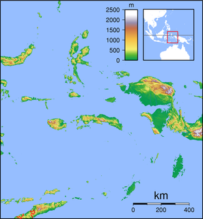
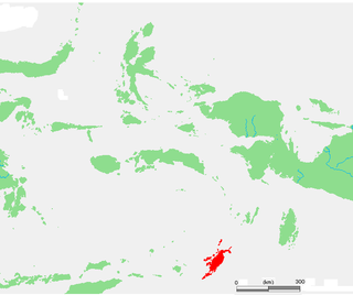
WThe Banda Islands are a volcanic group of ten small volcanic islands in the Banda Sea, about 140 km (87 mi) south of Seram Island and about 2,000 km (1,243 mi) east of Java, and constitute an administrative district (kecamatan) within the Central Maluku Regency in the Indonesian province of Maluku. The main town and administrative centre is Bandanaira, located on the island of the same name. They rise out of 4-to-6-kilometre deep ocean and have a total land area of approximately 172 square kilometres (66 sq mi). They had a population of 18,544 at the 2010 Census. Until the mid-19th century the Banda Islands were the world's only source of the spices nutmeg and mace, produced from the nutmeg tree. The islands are also popular destinations for scuba diving and snorkeling.
 W
WThe Banda Sea is a sea in the Maluku Islands of Indonesia, connected to the Pacific Ocean but surrounded by hundreds of islands, as well as the Halmahera and Ceram Seas. It is about 1000 km (600 mi) east to west, and about 500 km (300 mi) north to south.
 W
WThe Barat Daya Islands are a group of islands in the Maluku province of Indonesia. The Indonesian phrase barat daya means 'south-west'.
 W
WBoano Island is an island in West Seram Regency, Maluku Province, Indonesia. It is located off the northern coast of the Hoamoal Peninsula at the western end of Seram Island, across the Boano Strait. The inhabitants speak the Boano language, Luhu, as well as Indonesian and Ambonese Malay.
 W
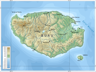
WBuru is the third largest island within Maluku Islands of Indonesia. It lies between the Banda Sea to the south and Seram Sea to the north, west of Ambon and Seram islands. The island belongs to Maluku province and includes the Buru and South Buru regencies. Their administrative centers, Namlea and Namrole, respectively, have ports and the largest towns of the island. There is a military airport at Namlea which supports civilian cargo transportation.
 W
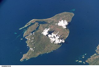
WGunungapi Wetar is an isolated volcanic island to the north of Wetar island in the Banda Sea, Indonesia. The island, a stratovolcano, only extends 282 m above sea level, but the total height of the summit from the sea bed is over 5000 m. Explosions in 1512 and 1699 are the only historical eruptions of the volcano.
 W
WHaruku Island is an island in Central Maluku Regency, Maluku Province, Indonesia - lying east of Ambon Island, off the southern coast of Seram and just west of Saparua. It is administered as a single district, Kecamatan Pulau Haruku, with a 2010 census population of 24,170. The inhabitants on Haruku speak the Haruku language, as well as Indonesian and Ambonese Malay.
 W
WKai Besar is one of the Kai Islands which are part of the Maluku Islands, Indonesia. Its area is 550 km2 (210 sq mi). The other main island in the Kai Islands group is Kai Kecil. The northern tip is called Tanjung Borang, and southern tip called Tanjung Weduar.
WThe Kai Islands of Indonesia are a group of islands in the southeastern part of the Maluku Islands, located in the province of Maluku. The Moluccas have been known as the Spice Islands due to regionally specific plants such as nutmeg, mace, and cloves that originally intrigued the European nations of the 16th century.
WKai Kecil is a part of the Kai Islands group of the Maluku Islands, Indonesia. Its area is 399 km2 (154 sq mi). The other main island in the group is Kai Besar. It contains the town of Tual.
WKelang Island is an island in West Seram Regency, Maluku Province, Indonesia. It is a mountainous island located off the western tip of Seram Island, just east of Manipa. Kampung Sole, located on the northeastern side, is the largest village. Tono, the highest point in the island, is an old volcano.
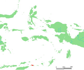
WKisar, also known as Yotowawa, is a small island in the Southwestern Moluccas in Indonesia, located to the northeast of Timor Island. It is included within the Southernmost Islands District within the Southwest Islands Regency of Maluku Province. The District also includes the larger Romang Island further north. It is one of the 92 officially listed outlying islands of Indonesia. The principal town is Wonreli, with 6,652 inhabitants at the 2010 Census.
 W
WThe Lease Islands, formerly called the Uliasers or Uliassers, are a group of three inhabited islands, lying immediately to the south of Seram and east of Ambon Island in the province of Maluku, in Indonesia. The three inhabited islands, from west to east, are Haruku, Saparua, Nusa Laut and tiny uninhabited Molana; these islands constitute four administrative districts (kecamatan) within Central Maluku Regency.
 W
WLeti is an Indonesian island, the westernmost of the Leti Islands, and one of the 92 officially listed outlying islands of Indonesia. Leti is located in southwest Maluku province. The main town is Sewaru.
 W
WThe Leti Islands of Indonesia are part of the Maluku Islands, in southwest Maluku Province. The main islands are Moa, Leti and Lakor; each of the three islands now constitutes a separate administrative district (kecamatan) within the Maluku Barat Daya Regency
 W
WManipa Island is an island in West Seram Regency, Maluku Province, Indonesia. It is located 8 km off the western coast of Kelang at the western end of Seram Island and 25 km off the western coast of Buru. The inhabitants speak the Manipa language, as well as Indonesian and Ambonese Malay.
 W
WMoa is an Indonesian island, at the center of the Leti Islands, and one of the 92 officially listed outlying islands of Indonesia. Moa is located in southwest Maluku province. The main town is Tiakur.
 W
WThe Molucca Sea is located in the western Pacific Ocean, around the vicinity of Indonesia, specifically bordered by the Indonesian Islands of Celebes (Sulawesi) to the west, Halmahera to the east, and the Sula Islands to the south. The Molucca Sea has a total surface area of 77,000 square miles. The Molucca Sea is rich in coral and has many diving sites due to the deepness of its waters. The deepness of the water explains the reasoning behind dividing the sea into three zones, which functions to transport water from the Pacific Ocean to the shallower seas surrounding it. The deepest hollow in the Molucca Sea is the 15,780-foot (4,810-meter) Batjan basin. This region is known for its periodic experiences of earthquakes, which stems from the sea itself being a micro plate, in which the Molucca Sea is being subducted in two opposite directions: one in the direction of the Eurasian Plate to the west and the other in the direction of the Philippines Sea Plate to the east.
 W
WNusa Laut is the smallest inhabited island in the Lease Islands group east of Ambon, in Indonesia's Maluku province. It lies just off the south-western corner of Saparua island, separated from it by a deep channel. The island's coasts are fringed by a drying reef.
 W
WSaparua is an island east of Ambon Island in the Indonesian province of Maluku; the island of Haruku lies between Saparua and Ambon. The main port is in the south at Kota Saparua. The island of Maolana is located near its southwestern side and Nusa Laut off its southeastern tip.
 W
WSeram is the largest and main island of Maluku province of Indonesia, despite Ambon Island's historical importance. It is located just north of the smaller Ambon Island and a few other surrounding islands, such as Haruku, Geser, Nusalaut, Banda and Saparua.
 W
WThe Seram Sea or Ceram Sea is one of several small seas between the scattered islands of Indonesia. It is a section of the Pacific Ocean with an area of approximately twelve thousand square kilometres (4,600 sq mi) located between Buru and Seram, which are two of the islands once called the South Moluccas. These islands are the native habitat of plants long coveted for their use as spices, such as nutmeg, cloves, and black peppercorns, and the seas surrounding them were busy shipping routes. The Seram Sea is also the habitat of several species of tropical goby and many other fish. Like many other small Indonesian seas, the Seram Sea is rocky and very tectonically active.
 W
WThe Tanimbar Islands, also called Timur Laut, are a group of about 65 islands in the Maluku province of Indonesia, including Fordata, Larat, Maru, Molu, Nuswotar, Selaru, Selu, Seira, Wotap, Wuliaru and Yamdena. The Indonesian phrase timur laut means "east of the sea" or "northeast".
 W
WThe Tayandu or Tayando Islands are a group of low-lying islands just west of the larger Kai Islands of Maluku, Indonesia. The main group consists of Tayando, Walir, Heniar and several smaller isle-lets. Between Walir and Taam is Pulau Nusreen featuring a large sandy lagoon. Manggur is further west with Kur and Kaimeer islands north of it. Administratively they comprise a district (kecamatan) within the city of Tual.
WTeor is an island in the Indonesian province of Maluku . It is also known as Pulau Tior, Tior, Tio'or and Téhor.
WWatubela is an archipelago in the Maluku Islands, east of Ceram and north of Kai Islands, southeast of the Gorong archipelago, and southwest of the Bomberai Peninsula of Papua, Indonesia. It includes the islands of Kasiui and Teor.