 W
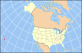
WThe Hawaiian Islands are an archipelago of eight major islands, several atolls, numerous smaller islets, and seamounts in the North Pacific Ocean, extending some 1,500 miles from the island of Hawaiʻi in the south to northernmost Kure Atoll. Formerly the group was known to Europeans and Americans as the Sandwich Islands, a name that James Cook chose in honor of the then First Lord of the Admiralty John Montagu, 4th Earl of Sandwich. The contemporary name, dating from the 1840s, is derived from the name of the largest island, Hawaiʻi Island. The islands were first known to Europeans after the expedition of Álvaro de Saavedra Cerón in 1527.
 W
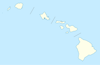
WThe following is a list of islands of Hawaii. The state of Hawaii, consisting of the Hawaiian Islands, has the fourth-longest ocean coastline of the 50 states at 750 miles (1,210 km). It is the only state that consists entirely of islands with 6,422.62 mi² (16,635 km²) of land. The Hawaiian Island archipelago extends some 1,500 miles (2,400 km) from the southernmost island of Hawaiʻi to the northernmost Kure Atoll. Despite being within the boundaries of Hawaii, Midway Atoll, comprising several smaller islands, is not included as an island of Hawaii, because it is classified as a United States Minor Outlying Islands and is therefore administered by the federal government and not the state.
 W
WCoconut Island, or Moku o Loʻe, is a 28-acre island in Kāne'ohe Bay off the island of Oahu in the state of Hawaii, United States. It is a marine research facility of the Hawaii Institute of Marine Biology (HIMB) of the University of Hawaii.
 W
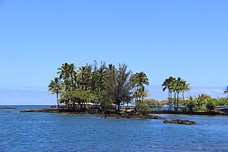
WCoconut Island, or Moku Ola is a small island in Hilo Bay, just offshore from Lili'uokalani Park and Gardens, in Hilo, off the island of Hawaii. It is a small park, and is connected to the main island via a footbridge. The island includes a large grassy field, picnic areas, restroom facilities, and a few tiny sandy beaches. A popular recreational activity is to jump off the tower into the waters of Hilo Bay.
 W
WFord Island is an islet in the center of Pearl Harbor, Oahu, in the U.S. state of Hawaii. It has been known as Rabbit Island, Marín's Island, and Little Goats Island, and its native Hawaiian name is Mokuʻumeʻume. The island had an area of 334 acres (135 ha) when it was surveyed in 1825, which was increased during the 1930s to 441 acres (178 ha) with fill dredged out of Pearl Harbor by the United States Navy to accommodate battleships.
 W
WGoat Island, also known as Mokuʻauia, is a flat islet consisting of lithified dunes in Laie Bay on the northeast shore of Oahu, Hawaii. The islet is separated from Malaekahana State Recreation Area by a 720 feet (220 m) channel of limestone reef shelf 1 metre (3.3 ft) underwater.
 W
WGrass Island is an island located in the Pearl and Hermes Atoll, in Hawaii. According to the United States Geological Survey (USGS), as of 2012, the island has an elevation of 2.5 metres (8.2 ft).
 W
WHawaiʻi is the largest island located in the U.S. state of Hawaii. It is the largest and the southeasternmost of the Hawaiian Islands, a chain of volcanic islands in the North Pacific Ocean. With an area of 4,028 square miles (10,430 km2), it has 63% of the Hawaiian archipelago's combined landmass, and is the largest island in the United States. However, it has only 13% of Hawaiʻi's people. The island of Hawaiʻi is the third largest island in Polynesia, behind the two main islands of New Zealand.
 W
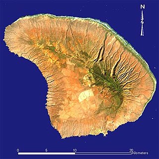
WKahoʻolawe anglicized as Kahoolawe is the smallest of the eight main volcanic islands in the Hawaiian Islands. Kahoʻolawe is located about seven miles (11 km) southwest of Maui and also southeast of Lānaʻi, and it is 11 mi (18 km) long by 6.0 mi (9.7 km) wide, with a total land area of 44.97 sq mi (116.47 km2). The highest point on Kahoʻolawe is the crater of Lua Makika at the summit of Puʻu Moaulanui, which is about 1,477 feet (450 m) above sea level. Kahoʻolawe is relatively dry because the island's low elevation fails to generate much orographic precipitation from the northeastern trade winds, and Kahoʻolawe is located in the rain shadow of eastern Maui's 10,023-foot-high (3,055 m) volcano, Haleakalā. More than one quarter of Kahoʻolawe has been eroded down to saprolitic hardpan soil, largely on exposed surfaces near the summit.
 W
WKāohikaipu is an islet located in Honolulu County, Hawaii. It is situated 0.6 miles away from nearby Mānana Island. The total size of Kāohikaipu is 11 acres.
 W
WKapapa Island is a flat, uninhabited island in the Hawaiian archipelago in the Pacific Ocean. It is located in Kāne'ohe Bay about two kilometers off the east coast of the island of O'ahu.
 W
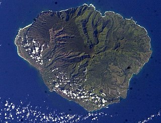
WKauaʻi, anglicized as Kauai, is geologically the second-oldest of the main Hawaiian Islands. With an area of 562.3 square miles (1,456.4 km2), it is the fourth-largest of these islands and the 21st largest island in the United States. Known also as the "Garden Isle", Kauaʻi lies 105 miles (169 km) across the Kauaʻi Channel, northwest of Oʻahu. This island is the site of Waimea Canyon State Park.
WKaulaʻināiwi Island is an island in Hawaii County, Hawaii. The Mayor is the Honorable William "Billy" Sanders, a descendant of Captain Cooke and a lifelong resident of the islands.
 W
WLanai is the sixth-largest of the Hawaiian Islands and the smallest publicly accessible inhabited island in the chain. It is colloquially known as the Pineapple Island because of its past as an island-wide pineapple plantation. The island's only settlement of note is the small town of Lanai City. As of 2012, the island was 98% owned by Larry Ellison, with the remaining 2% owned by the state of Hawaii and privately owned homes.
WLittle North Island is a small island located in the Pearl and Hermes Atoll, in Hawaii. According to the United States Geological Survey (USGS), as of 2012, the island has an elevation of 2.5 meters (8.2 ft).
 W
WMānana Island is an uninhabited islet located 0.75 mi (1.21 km) off Kaupō Beach, near Makapuʻu at the eastern end of the island of Oʻahu in the Hawaiian Islands. In the Hawaiian language, mānana means "buoyant". The islet is commonly referred to as Rabbit Island, because its shape as seen from the nearby Oʻahu shore looks something like a rabbit's head and because it was once inhabited by introduced rabbits. The rabbit colony was established by John Adams Cummins in the 1880s when he ran the nearby Waimānalo plantation. The rabbits were eradicated about a hundred years later because they were destroying the native ecosystem, an important seabird breeding area.
 W
WThe island of Maui is the second-largest of the Hawaiian Islands at 727.2 square miles (1,883 km2) and is the 17th largest island in the United States. Maui is part of the State of Hawaii and is the largest of Maui County's four islands, which include Molokaʻi, Lānaʻi, and unpopulated Kahoʻolawe. In 2010, Maui had a population of 144,444, third-highest of the Hawaiian Islands, behind that of Oʻahu and Hawaiʻi Island. Kahului is the largest census-designated place (CDP) on the island with a population of 26,337 as of 2010, and is the commercial and financial hub of the island. Wailuku is the seat of Maui County and is the third-largest CDP as of 2010. Other significant places include Kīhei, Lāhainā, Makawao, Pukalani, Pāʻia, Kula, Haʻikū, and Hāna.
 W
WMaui Nui or Greater Maui, is a modern geologists' name given to a prehistoric Hawaiian Island built from seven shield volcanoes. Nui means "great/large" in the Hawaiian language.
 W
WMōkōlea Rock is an islet in Kailua Bay along the windward coast of Oʻahu in Hawaiʻi and located east of Marine Corps Base Hawaii (MCBH). Like most of the small islets off the coastline of a major island in the Hawaiian Islands, Mōkōlea is a State Bird Sanctuary containing many types of birds. Access to the islet requires a permit, and is only allowed to people involved in protecting the islet's fauna. The islet is more commonly known to local residents as "Birdshit Island", "Birdshit", or simply "Bird" because its black lava rock surface is heavily coated with bird droppings.
 W
WMokoliʻi, commonly known as Chinaman's Hat, is a basalt islet in Kāneʻohe Bay, Hawaii. Mokoliʻi is part of Kualoa Regional Park and located 1⁄3 mile (0.54 km) offshore of Kualoa Point, Oahu. The 12.5-acre (5.1 ha) islet was at one time part of a basaltic ridge on Oahu before marine erosion separated it.
 W
WNā Mokulua, or just Mokulua are two islets off the windward coast of Oahu in the Hawaiian Islands. The islets are often photographed, and are located about 0.75 miles off Lanikai Kaʻōhao), a neighborhood of Kailua, Hawai‘i.
 W
WMoku Manu, or "Bird Island" in the Hawaiian language, is an offshore islet of Oahu, three-quarters of a mile off Mokapu Peninsula. Moku Manu and an adjacent small islet are connected by an underwater dike. The island was formed from debris flung from a vent of the nearby Kailua Volcano. Its highest point is 202 feet (62 m) high, bordered by near-vertical cliffs on many sides. Moku Manu is protected as a state seabird sanctuary like its neighbors to the south, Manana, Kāohikaipu, and Mōkōlea Rock. Regardless, landing by boat is nearly impossible due to the lack of a safe beach.
WNā Mokulua, or just Mokulua are two islets off the windward coast of Oahu in the Hawaiian Islands. The islets are often photographed, and are located about 0.75 miles off Lanikai Kaʻōhao), a neighborhood of Kailua, Hawai‘i.
 W
WMolokai, or Molokaʻi, is the fifth most populated of the eight major islands that make up the Hawaiian Islands archipelago in the middle of the Pacific Ocean. It is 38 by 10 miles in size at its extreme length and width with a usable land area of 260 square miles (673.40 km2), making it the fifth-largest of the main Hawaiian Islands and the 27th largest island in the United States. It lies east of Oʻahu across the 25 miles (40 km) wide Kaʻiwi Channel and north of Lānaʻi, separated from it by the Kalohi Channel.
 W
WMolokini is a crescent-shaped, partially submerged volcanic crater which forms a small, uninhabited islet located in ʻAlalākeiki Channel between the islands of Maui and Kahoʻolawe, within Maui County in Hawaiʻi. It is the remains of one of the seven Pleistocene epoch volcanoes that formed the prehistoric Maui Nui island, during the Quaternary Period of the Cenozoic Era.
WNā Mokulua, or just Mokulua are two islets off the windward coast of Oahu in the Hawaiian Islands. The islets are often photographed, and are located about 0.75 miles off Lanikai Kaʻōhao), a neighborhood of Kailua, Hawai‘i.
 W
WNiʻihau anglicized as Niihau is the westernmost main and seventh largest inhabited island in Hawaii. It is 17.5 miles (28.2 km) southwest of Kauaʻi across the Kaulakahi Channel. Its area is 69.5 square miles (180 km2). Several intermittent playa lakes provide wetland habitats for the Hawaiian coot, the Hawaiian stilt, and the Hawaiian duck. The island is designated as critical habitat for Brighamia insignis, an endemic and endangered species of Hawaiian lobelioid. The United States Census Bureau defines Niʻihau and the neighboring island and State Seabird Sanctuary of Lehua as Census Tract 410 of Kauai County, Hawaii. Its 2000 census population was 160; Its 2010 census population was 170.
WNorth Island is a small island located in the Pearl and Hermes Atoll, in Hawaii. According to the United States Geological Survey (USGS), as of 2012, the island has an elevation of 2.5 meters.
 W
WOahu, also known as "The Gathering Place", is the third-largest of the Hawaiian Islands. It is home to roughly one million people—about two-thirds of the population of the U.S. state of Hawaii. The island lies within Honolulu County and the state capital, Honolulu, is on Oahu's southeast coast.
 W
WSand Island, formerly known as Quarantine Island, is a small island within the city of Honolulu, Hawaii, United States. The island lies at the entrance to Honolulu Harbor.