 W
WThe Cuyamaca Mountains, locally the Cuyamacas, are a mountain range of the Peninsular Ranges System, in San Diego County, southern California. The mountain range runs roughly northwest to southeast. The Laguna Mountains are directly adjacent to the east, with Palomar Mountain and Hot Springs Mountain more distant to the north.
 W
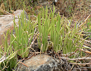
WDudleya edulis is a succulent plant known by the common name fingertips.
 W
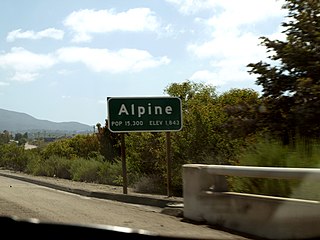
WAlpine is a census-designated place (CDP) in the Cuyamaca Mountains of San Diego County, California. Alpine had a population of 14,236 at the 2010 census, up from 13,143 at the 2000 census. The town is largely surrounded by the Cleveland National Forest and borders two reservations of the Kumeyaay Nation, Viejas and Sycuan, and the rural unincorporated areas of the city of El Cajon.
 W
WCalifornia Wolf Center is a 501(c)3 nonprofit located 50 miles east of San Diego, near the town of Julian, California. It is a conservation, education, and research center dedicated to wolf recovery in the wild. They are a statewide organization with staff and volunteers throughout California striving to pave the way for the return of wolves in California. Founded in 1977 to educate the public about wildlife and ecology, the Center is currently home to several packs of gray wolves, some of which play an important role in educational programs. These wolves serve as ambassadors representing wolves in the wild. The Center also hosts highly endangered Mexican gray wolves, now being reintroduced into the southwestern United States.
 W
WCalochortus dunnii is a rare species of flowering plant in the lily family known by the common name Dunn's mariposa lily.
 W
WThe Capitan Grande Reservation is a Kumeyaay Indian reservation in San Diego County, California, jointly controlled by the Barona Group of Capitan Grande Band of Mission Indians and Viejas Group of Capitan Grande Band of Mission Indians. The reservation is uninhabited and is 15,753 acres (63.75 km2) large, located in the Cuyamaca Mountains and middle of the Cleveland National Forest and west of Cuyamaca Peak. The closest town is Alpine, California.
 W
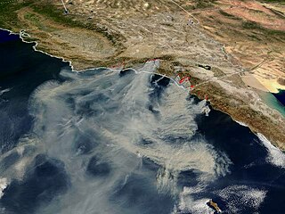
WThe Cedar Fire was a massive, highly-destructive wildfire, which burned 273,246 acres (1,106 km2) of land in San Diego County, California, during October and November 2003. The fire's rapid growth was driven by the Santa Ana winds, causing the fire to spread at a rate of 3,600 acres (15 km2) per hour. By the time the fire was fully contained on November 4, it had destroyed 2,820 buildings and killed 15 people, including one firefighter. Hotspots continued to burn within the Cedar Fire's perimeter until December 5, 2003, when the fire was fully brought under control.
WChiquito Peak, is a summit in the Cuyamaca Mountains of San Diego County, California.
 W
WCleveland National Forest encompasses 460,000 acres, mostly of chaparral, with a few riparian areas. A warm dry mediterranean climate prevails over the forest. It is the southernmost U.S. National Forest of California. It is administered by the U.S. Forest Service, a government agency within the United States Department of Agriculture. It is divided into the Descanso, Palomar and Trabuco Ranger Districts and is located in the counties of San Diego, Riverside, and Orange.
 W
WCupressus stephensonii is a species of conifer known as the Cuyamaca cypress, and is endemic to southern California. It has been classified as Hesperocyparis stephensonii. It was previously listed as Cupressus arizonica subsp. stephensonii and Cupressus arizonica var. glabra.
 W
WCuyamaca Peak is a mountain peak of the Cuyamaca Mountains range, in San Diego County, Southern California.
 W
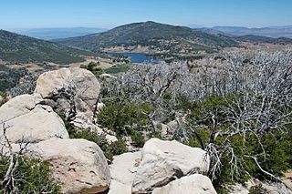
WCuyamaca Rancho State Park is a state park in California, United States, located 40 miles (64 km) east of San Diego in the Cuyamaca and Laguna Mountains of the Peninsular Ranges. The park's 26,000 acres (11,000 ha) feature pine, fir, and oak forests, with meadows and streams that exist due to the relatively high elevation of the area compared to its surroundings. The park includes 6,512-foot (1,985 m) Cuyamaca Peak, the second-highest point in San Diego County.
 W
WDescanso is a small census-designated place in the Cuyamaca Mountains, within the Mountain Empire area of southeastern San Diego County, California.
 W
WEl Cajon Mountain, commonly known as El Capitan or El cap, is a mountain in the Cuyamaca Mountains, and prominent natural landmark in the East County of San Diego.
 W
WEl Capitan Reservoir is a reservoir in central San Diego County, California. It is in the Cuyamaca Mountains, about 30 miles (48 km) northeast of the city of San Diego and two miles northwest of the town of Alpine.
 W
WGuatay is an unincorporated community in the Cuyamaca Mountains, in the Mountain Empire area of southeastern San Diego County, California.
WCupressus stephensonii is a species of conifer known as the Cuyamaca cypress, and is endemic to southern California. It has been classified as Hesperocyparis stephensonii. It was previously listed as Cupressus arizonica subsp. stephensonii and Cupressus arizonica var. glabra.
 W
WJulian is a census-designated place (CDP) in San Diego County, California, in the United States. As of the 2010 census, the population was 1,502, down from 1,621 at the 2000 census.
 W
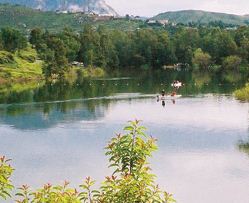
WLake Cuyamaca, also called Cuyamaca Lake, or Cuyamaca Reservoir, is a 110 acres (45 ha) reservoir and a recreation area in the eastern Cuyamaca Mountains, located in eastern San Diego County, California.
 W
WLake Jennings is a water supply reservoir in San Diego County, California. It is located in Lakeside, Ca.
 W
WLakeside is a census designated place (CDP) in San Diego County, California. The population was 20,648 at the 2010 census, up from 19,560 as of the 2000 census.
 W
WThe Mountain Empire is a rural area in southeastern San Diego County, California. The Mountain Empire subregion consists of the backcountry communities in southeastern San Diego County. The area is also sometimes considered part of the East County region of San Diego County.
WPine Valley is a community and census-designated place (CDP) in the Cuyamaca Mountains of the Mountain Empire area, in southeastern San Diego County, California. The population was 1,510 at the 2010 census, up from 1,501 at the 2000 census.
 W
WThe San Diego River is a river in San Diego County, California. It originates in the Cuyamaca Mountains northwest of the town of Julian, then flows to the southwest until it reaches the El Capitan Reservoir, the largest reservoir in the river's watershed at 112,800 acre feet (139,100,000 m3). Below El Capitan Dam, the river runs west through Santee and San Diego. While passing through Tierrasanta it goes through Mission Trails Regional Park, one of the largest urban parks in America. The river discharges into the Pacific Ocean near the entrance to Mission Bay, forming an estuary.
WSan Vicente Reservoir is a reservoir created by the San Vicente Dam in San Diego County, California. It is located in the Cuyamaca Mountains, approximately 4.3 miles (6.9 km) north of Lakeside off California State Route 67.
 W
WThe Sweetwater Dam is a dam across the Sweetwater River in San Diego County, California. It is located approximately 12 miles (19 km) east of San Diego, 9 miles (14 km) and borders Bonita to the southwest and La Presa to the northeast. The 108-foot (33 m)-high masonry arch dam impounds 960-acre (390 ha) Sweetwater Reservoir.
 W
WThe Sweetwater River is a 55-mile (89 km) long stream in San Diego County, California.
 W
WThe Viejas Group of Capitan Grande Band of Mission Indians of the Viejas Reservation, also called the Viejas Band of Kumeyaay Indians, is a federally recognized tribe of Kumeyaay Indians.
WWhale Mountain is a 3,043-foot (928 m), summit in the northwestern Cuyamaca Mountains, in San Diego County, California. It is located between Ramona, and Santa Ysabel, near Ballena Valley.