 W
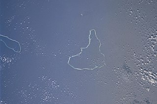
WAilinginae Atoll is an uninhabited coral atoll of 25 islands in the Pacific Ocean, on the northern end of the Ralik Chain of the Marshall Islands. Its total land area is only 2.8 square kilometres (1.1 sq mi), but it encloses a lagoon of 105.96 square kilometres (40.91 sq mi). It is located approximately 13 kilometres (8.1 mi) west of Rongelap Atoll. The landscape is low-lying with only the top 3 metres (9.8 ft) above sea level. The two entrances into the lagoon are 'Mogiri Pass' and 'Eniibukku Pass'. These are 1.45 and 0.48 kilometres wide respectively.
 W
WAilinglaplap or Ailinglapalap is a coral atoll of 56 islands in the Pacific Ocean, and forms a legislative district of the Ralik Chain in the Marshall Islands. It is located 152 kilometres (94 mi) northwest of Jaluit Atoll. Its total land area is only 14.7 square kilometres (5.7 sq mi), but it encloses a lagoon of 750 square kilometres (290 sq mi). The economy of the atoll is dominated by coconut plantations. The population of the atoll was 1,729 in 2011. Jabat Island is located off the coast of Ailinglaplap Atoll. The former president of the Marshall Islands, Kessai Note, was born on Jeh Island, Ailinglaplap Atoll.
 W
WAiluk Atoll is a coral atoll of 57 islets in the Pacific Ocean, and forms a legislative district of the Ratak Chain of the Marshall Islands. It is located approximately 72 kilometres (45 mi) north from Wotje. Its total land area is only 5.4 square kilometres (2.1 sq mi), but it encloses a lagoon with an area of 177.45 square kilometres (68.51 sq mi). The major islets are: Ajelep, Aliej, Ailuk, Alkilwe, Barorkan, Biken, Enejabrok, Enejelar, Kapen and Marib. Most of the islets are on the eastern side of the atoll. The western and southern sides of the atoll have a nearly continuous submerged coral reef, with three main passes that lead into the lagoon: Erappu Channel, Marok Channel and Eneneman Channel on the west side.
 W
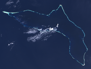
WArno Atoll is a coral atoll of 133 islands in the Pacific Ocean, and forms a legislative district of the Ratak Chain of the Marshall Islands. Its total land area is only 5 square miles (13 km2). Unlike most other atolls, Arno encloses three different lagoons, a large central one, and two smaller ones in the north and east. Its main lagoon encloses an area of 130.77 square miles (338.7 km2). At a distance of only 20 kilometres (12 mi), it is the closest atoll to the Marshall Islands capital, Majuro Atoll, and can be seen looking east from Majuro on a clear day at low tide. The population of Arno Atoll was 1,794 at the 2011 census. The most populous islets are Ajeltokrok, Kobjeltak, Rearlaplap, Langor and Tutu. The largest village is Ine, Arno.
 W
WAur Atoll is a coral atoll of 42 islands in the Pacific Ocean, and forms a legislative district of the Ratak Chain of the Marshall Islands. Its total land area is only 15 square kilometres (5.6 sq mi), but it encloses a lagoon with an area of 620 square kilometres (240 sq mi). It is located south of Maloelap Atoll. The population of Aur Atoll was 499 in 2011.
 W
WBikar Atoll is an uninhabited atoll in the Ratak Chain of the Marshall Islands. It is one of the smallest atolls in the Marshalls. Due to its relative isolation from the main islands in the group, Bikar's flora and fauna has been able to exist in a relatively pristine condition.
 W
WBikini Atoll, sometimes known as Eschscholtz Atoll between the 1800s and 1946, is a coral reef in the Marshall Islands consisting of 23 islands surrounding a 229.4-square-mile (594.1 km2) central lagoon. After the Second World War, the atoll's inhabitants were relocated in 1946, after which the islands and lagoon were the site of 23 nuclear tests by the United States until 1958.
 W
WBokak Atoll or Taongi Atoll is an uninhabited coral atoll in the Ratak Chain of the Marshall Islands, in the North Pacific Ocean. Due to its relative isolation from the main islands in the group, Bokak's flora and fauna has been able to exist in a pristine condition.
 W
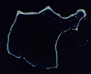
WEbon Atoll is a coral atoll of 22 islands in the Pacific Ocean, forming a legislative district of the Ralik Chain of the Marshall Islands. Its land area is 5.75 square kilometres (2.22 sq mi), and it encloses a deep lagoon with an area of 104 square kilometres (40 sq mi). A winding passage, the Ebon Channel, leads to the lagoon from the southwest edge of the atoll. Ebon Atoll is approximately 155 kilometres (96 mi) south of Jaluit, and it is the southernmost land mass of the Marshall Islands, on the southern extremity of the Ralik Chain. In documents and accounts from the 1800s, it was also known as Boston, Covell's Group, Fourteen Islands, and Linnez.
 W
WEnewetak Atoll is a large coral atoll of 40 islands in the Pacific Ocean and with its 664 people forms a legislative district of the Ralik Chain of the Marshall Islands. With a land area total less than 5.85 square kilometres (2.26 sq mi), it is no higher than 5 meters (16.4 ft) and surrounds a deep central lagoon, 80 kilometres (50 mi) in circumference. It is the second-westernmost atoll of the Ralik Chain and is 305 kilometres (190 mi) west from Bikini Atoll.
 W
WErikub Atoll is an uninhabited coral atoll of fourteen islands in the Pacific Ocean, located in the Ratak Chain of the Marshall Islands. Its total land area is only 1.53 square kilometres (0.59 sq mi), but it encloses a lagoon with an area of 230 square kilometres (89 sq mi). It is located slightly south of Wotje.
 W
WJaluit Atoll is a large coral atoll of 91 islands in the Pacific Ocean and forms a legislative district of the Ralik Chain of the Marshall Islands. Its total land area is 11.34 square kilometres (4.38 sq mi), and it encloses a lagoon with an area of 690 square kilometres (270 sq mi). Most of the land area is on the largest islet (motu) of Jaluit (10.4 km²). Jaluit is approximately 220 kilometres (140 mi) southwest of Majuro. Jaluit Atoll is a designated conservation area and Ramsar Wetland.
 W
WKili Island or Kili Atoll is a small, 81 hectares island located in the Marshall Islands in the Pacific Ocean. It is the temporary home of 548 inhabitants who are descended from islanders who originally lived on Bikini Atoll. They were relocated when they agreed to let the U.S. government temporarily use their home for nuclear testing in 1945. Kili Island became their home after two prior relocations failed. The island does not have a natural lagoon and cannot produce enough food to enable the islanders to be self-sufficient. It is part of the legislative district of the Ralik Chain of the Marshall Islands. The island is approximately 48 kilometers (30 mi) southwest of Jaluit. It is one of the smallest islands in the Marshall Islands.
 W
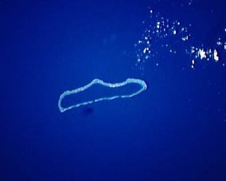
WKnox Atoll is an uninhabited coral atoll of 18 islands in the Pacific Ocean, and is the southernmost atoll of the Ratak Chain of the Marshall Islands. The total land area is only 0.98 square kilometres (0.38 sq mi), but it encloses a largely sand-filled lagoon with an area of 3.42 square kilometres (1.32 sq mi). The atoll measures 11 kilometres (6.8 mi) in length and is 2 kilometres (1.2 mi) wide. The largest islets, located on the western and northern sides, include Aelingeo, Nadikdik and Nariktal. The atoll is separated by the Klee Passage from the southern point of Mili Atoll to which it was once connected.
 W
WKwajalein Atoll is part of the Republic of the Marshall Islands (RMI). The southernmost and largest island in the atoll is named Kwajalein Island, which its majority English-speaking residents often called by the shortened name, Kwaj. The total land area of the atoll amounts to just over 6 square miles (16 km2). It lies in the Ralik Chain, 2,100 nautical miles southwest of Honolulu, Hawaii.
 W
WLae Atoll is a coral atoll of 20 islands in the Pacific Ocean, and forms a legislative district of the Ralik Chain of the Marshall Islands. Its total land area is only 1.5 square kilometres (0.58 sq mi), but it encloses a lagoon with an area of 17.7 square kilometres (6.8 sq mi). It is located approximately 47 kilometres (29 mi) east of Ujae Atoll. The population of Lae Atoll was 347 in 2011.
 W
WLikiep Atoll is a coral atoll of 65 islands in the Pacific Ocean, and forms a legislative district of the Ratak Chain of the Marshall Islands. It is approximately 55 kilometres (34 mi) northwest of Wotje. Its total land area is only 10.26 square kilometres (3.96 sq mi), but that encloses a deep central lagoon of 424 square kilometres (164 sq mi). Likiep Atoll also possesses the Marshall Islands' highest point, an unnamed knoll 10 metres (33 ft) above sea level. The population of Likiep Atoll was 401 in 2011.
 W
WMajuro is the capital and largest city of the Marshall Islands. It is also a large coral atoll of 64 islands in the Pacific Ocean. It forms a legislative district of the Ratak (Sunrise) Chain of the Marshall Islands. The atoll has a land area of 9.7 square kilometres (3.7 sq mi) and encloses a lagoon of 295 square kilometres (114 sq mi). As with other atolls in the Marshall Islands, Majuro consists of narrow land masses. It has a tropical trade wind climate, with an average temperature of 27 °C (81 °F).
WThe Maloelap Atoll is a coral atoll of 71 islands in the Pacific Ocean, and forms a legislative district of the Ratak Chain of the Marshall Islands. Its land area is only 9.8 square kilometres (3.8 sq mi), but that encloses a lagoon of 972 square kilometres (375 sq mi). It is located 18 kilometres (11 mi) north of the atoll of Aur. In 2011 the population of the islands of the atoll was 682.
 W
WNamdrik Atoll or Namorik Atoll is a coral atoll of two islands in the Pacific Ocean, and forms a legislative district of the Ralik Chain of the Marshall Islands. Its total land area is only 2.8 square kilometres (1.1 sq mi), but it encloses a lagoon with an area of 8.4 square kilometres (3.2 sq mi).
 W
WNamu Atoll is a coral atoll of 54 islands in the Pacific Ocean, and forms a legislative district of the Ralik Chain of the Marshall Islands. Its total land area is only 6.27 square kilometres (2.42 sq mi), but that encloses a lagoon of 397 square kilometres (153 sq mi). It is located approximately 62 kilometres (39 mi) south-southwest of Kwajalein Atoll.
 W
WRongelap Atoll RONG-gə-lap is a coral atoll of 61 islands in the Pacific Ocean, and forms a legislative district of the Ralik Chain of the Marshall Islands. Its total land area is 8 square miles (21 km2). It encloses a lagoon with an area of 1,000 square miles (2,600 km2). It is historically notable for its close proximity to US hydrogen bomb tests in 1954, and was particularly devastated by fallout from the Castle Bravo test. The population was evacuated from Rongelap following the test due to high radiation levels. However, according to the most recent census in 2011 it has begun to recover with about eighty people living on the atoll.
 W
WRongerik Atoll or Rongdrik Atoll is a coral atoll of 17 islands in the Pacific Ocean, and is located in the Ralik Chain of the Marshall Islands, approximately 200 kilometres (120 mi) east of Bikini Atoll. Its total land area is only 1.68 square kilometres (0.65 sq mi), but it encloses a lagoon of 144 square kilometres (56 sq mi).
 W
WToke Atoll or Taka Atoll is a small, uninhabited coral atoll in the Ratak Chain of the Marshall Islands. It is one of the smaller atolls in the Marshalls and located at 11°17′N 169°37′E. It is visited regularly by the residents of nearby Utirik Atoll.
 W
WUjae Atoll is a coral atoll of 15 islands in the Pacific Ocean, and forms a legislative district of the Ralik Chain of the Marshall Islands. Its total land area is only 1.86 square kilometres (0.72 sq mi), but it encloses a lagoon of 185.94 square kilometres (71.79 sq mi). It is located about 122 kilometres (76 mi) west of Kwajalein Atoll.
 W
WUjelang Atoll is a coral atoll of 30 islands in the Pacific Ocean, in the Ralik Chain of the Marshall Islands. Its total land area is 1.86 square kilometres (0.72 sq mi), and it encloses a lagoon of 185.94 square kilometres (71.79 sq mi). It is the westernmost island in the Marshall Islands, approximately 217 kilometres (135 mi) southeast of Enewetak, and approximately 600 kilometres (370 mi) west of the main Ralik Chain.
 W
WUtirik Atoll or Utrik Atoll is a coral atoll of 10 islands in the Pacific Ocean, and forms a legislative district of the Ratak Chain of the Marshall Islands. Its total land area is only 2.4 square kilometres (0.94 sq mi), but it encloses a lagoon with an area of 57.7 square kilometres (22.29 sq mi). It is located approximately 47 kilometres (29 mi) east of Ujae Atoll. The population of Utirik Atoll is 300-400 as of 2020. it is one of the northernmost Marshall Islands with permanent habitation.
 W
WWotho Atoll is a coral atoll of 13 islands in the Pacific Ocean, and forms a legislative district of the Ralik Chain of the Marshall Islands. Its total land area is only 4.33 square kilometres (1.67 sq mi), but it encloses a lagoon of 94.92 square kilometres (36.65 sq mi). The name "Wotho" means either "entrance through the reef", or "island far away" according to different sources.
WWotje Atoll is a coral atoll of 75 islands in the Pacific Ocean, and forms a legislative district of the Ratak Chain of the Marshall Islands.