 W
WThe Toronto waterway system comprises a series of natural and man-made watercourses in the Canadian city of Toronto. The city is dominated by a large river system spanning most of the city including the Don River, Etobicoke Creek, Highland Creek, Humber River, Mimico Creek and Rouge River.
 W
WAshbridge's Creek was a watercourse that flowed in Ashbridge's Bay, between the Don River and Highland Creek. Its headwaters were north of Greenwood and Danforth avenues, making it about 4 kilometres (2.5 mi) long.
 W
WBlack Creek is a river in the Golden Horseshoe region of Ontario, Canada. It flows from the city of Vaughan in the Regional Municipality of York to the Humber River in Toronto. Black Creek is smaller than most of the waterways in the Greater Toronto Area.
 W
WBonar Creek was a creek in Mimico, Ontario, Canada. It was a tributary of the still-existing Mimico Creek, a watercourse that empties into Lake Ontario. Bonar Creek joined Mimico Creek 130 metres (430 ft) north of Lake Shore Boulevard, in the marsh at the mouth of the Mimico Creek.
 W
WBurke Brook is a small stream in Toronto, Ontario. It is part of the Don River watershield, a major river that flows into Lake Ontario. The north end of the stream begins near Glenview Senior Public School.
 W
WCastle Frank Brook is a buried creek and south-west flowing tributary of the Don River in central and north-western Toronto, Ontario, originating near the intersection of Lawrence Avenue and Dufferin Street.
 W
WThe Don River is a watercourse in southern Ontario, that empties into Lake Ontario, at Toronto Harbour. Its mouth was just east of the street grid of the town of York, Upper Canada, the municipality that evolved into Toronto, Ontario. The Don is one of the major watercourses draining Toronto that have headwaters in the Oak Ridges Moraine.
 W
WEdwards Gardens is a botanical garden located on the southwest corner of Leslie Street and Lawrence Avenue East in Toronto, Ontario, Canada. It is also the site of the Toronto Botanical Garden, a private not-for profit organization previously called the Civic Garden Centre.
 W
WEtobicoke Creek is a river in the Greater Toronto Area of Ontario, Canada. It is a tributary of Lake Ontario and runs from Caledon to southern Etobicoke, part of the City of Toronto. The creek is within the jurisdiction of the Toronto and Region Conservation Authority.
 W
WGarrison Creek was a short stream about 7.7 kilometres (4.8 mi) long that flowed southeast into the west side of Toronto Harbour in Ontario, Canada. It has been largely covered over and filled in, but geographical traces of the creek can still be found. The natural amphitheatre known as Christie Pits is one such remnant; the off-leash dog "bowl" of Trinity Bellwoods Park is another. The name "Garrison Creek" was used because Fort York was built near the creek mouth. Volunteers lead popular tours of the course of the old watershed.
 W
WGerman Mills Creek is a river in the municipalities of Markham, Richmond Hill, Toronto and Vaughan in the Greater Toronto Area of Ontario, Canada. It is part of the Great Lakes Basin and is a left tributary of the East Branch Don River. It originates in Vaughan, flows south through Richmond Hill and Markham, and empties into the East Branch Don River in the East Don Parklands in Toronto, south of Steeles Avenue between Bayview Avenue and Leslie Street. It is part of a number of streams, swamps and swales located near the Oak Ridges Moraine. The creek's approximate length is 10 kilometres (6 mi).
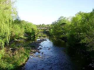
WHighland Creek is a river in the Scarborough district of Toronto, Ontario, emptying into Lake Ontario at the eastern end of the Scarborough Bluffs. It is home to several species of fish including trout, carp, bass and salmon. It is a meandering river which, like most rivers in Toronto, travels through a glacial ravine formed after the last Ice Age. The Highland Creek watershed, including tributaries, is almost entirely contained within Scarborough.
 W
WThe Humber River is a river in Southern Ontario, Canada. It is in the Great Lakes Basin, is a tributary of Lake Ontario and is one of two major rivers on either side of the city of Toronto, the other being the Don River to the east. It was designated a Canadian Heritage River on September 24, 1999.
 W
WJackson Creek is a watercourse that flows into Lake Ontario near 10th Street, in the New Toronto neighbourhood of Etobicoke, a suburb of Toronto, Ontario, Canada. It is part of the Great Lakes Basin. Its headwaters were approximately five kilometers northwest—north of Bloor Street, near Highway 427. Portions of the watercourse remain above-ground today. The creek is named for Jackson Farm, the historical location of its mouth.
 W
WThe Keating Channel is a 1,000-metre (3,300 ft) long waterway in Toronto, Ontario, Canada. It connects the Don River to inner Toronto Harbour on Lake Ontario. The channel is named after Edward Henry Keating (1844-1912), a city engineer (1892-1898) who proposed the creation of the channel in 1893. The channel was built to connect Ashbridge's Bay to the harbour; later, the Don was diverted into the channel, and its river mouth infilled in the early 1910s.
 W
WMimico Creek is a stream that flows through Brampton, Mississauga and Toronto in the Greater Toronto Area of Ontario, Canada. It is 33 kilometres (21 mi) long, is in the Great Lakes Basin, and is a tributary of Lake Ontario.
 W
WMud Creek, is a mostly buried south-easterly tributary of the Don River in Toronto, Ontario, Canada. It has also been known at different times as Mount Pleasant Brook and Spring Valley Creek.
 W
WNorth Creek is a mostly buried watercourse that flows into Lake Ontario on the grounds of the former Lakeshore Psychiatric Hospital now in Colonel Samuel Smith Park. Its mouth was at Kipling Avenue. Its headwaters were near the present day intersection of the Queen Elizabeth Way and Browns Line. Almost all the creek had been buried by 1960, but part of the creek remains and mouth now flows in an easterly direction instead of southerly into Lake Ontario.
 W
WPetticoat Creek is a stream in the cities of Pickering, Toronto and Markham in the Greater Toronto Area of Ontario, Canada. The creek is in the Great Lakes Basin, is a tributary of Lake Ontario, and falls under the auspices of the Toronto and Region Conservation Authority. Its watershed covers 26.77 square kilometres (10.34 sq mi), and the cumulative length of all its branches is 49 kilometres (30 mi). Land use in the watershed consists of 52% agricultural, 27% protected greenspace and 21% urban.
 W
WThe Rouge River is a river in Markham, Pickering, Richmond Hill and Toronto in the Greater Toronto Area of Ontario, Canada. The river flows from the Oak Ridges Moraine to Lake Ontario at the eastern border of Toronto, and is the location of Rouge Park, the only national park in Canada within a municipality. At its southern end, the Rouge River is the boundary between Toronto and southwestern Pickering in the Regional Municipality of Durham.
 W
WRussell Creek was a short creek, 3.4 kilometres (2.1 mi) long, that flowed through what is now downtown Toronto, Ontario, Canada, west of the original town of York. The creek was named for Peter Russell and flowed generally southeast, like all the other waterways in Toronto, reflecting the recent glaciation, into Toronto Harbour near the present CN Tower. The creek was buried in 1876, but traces of it can still be found, for instance on the grounds of the historic Grange mansion.
 W
WSmall's Creek was one of the three watercourses that flowed into Small's Pond, a small body of water of several acres in area, located near the intersection of Queen Street and Kingston Road, in Toronto, Ontario. There is a small plain between the shore of Lake Ontario and the bluffs which marked the shore of the larger Glacial Lake Iroquois, Bedrock was shallow on the plain. Smalls Creek, Tomlin's Creek, the other watercourse that drains into Smalls Pond, and Ashbridge's Creek to the east were all small, short watercourses, with their headwaters on that small plain, had each become polluted by the turn of the 20th century, when the regions they flowed through were annexed into the growing city of Toronto.
 W
WSuperior Creek was a stream draining into Lake Ontario in the former village of Mimico, Ontario, Canada. It was approximately 3 kilometers long, with headwaters near the present intersection of Kipling Avenue and The Queensway. The lower reaches of the creek had become polluted, and were buried in a sewer in 1915. In 1954 citizens of Mimico living in newly built houses near the upper reaches complained that the creek flooded, and lobbied to have the creek replaced by storm sewers, and a study was prepared. According to HTO: Toronto's water from Lake Iroquois to lost rivers to low-flow toilets, the creek was buried around 1965.
 W
WTaddle Creek is a buried stream in Toronto, Ontario, Canada that flowed a southeasterly course about six kilometres long, from St. Clair Avenue west of Bathurst Street through the present site of Wychwood Park, through the University of Toronto, into the Toronto Harbour near the Distillery District. During the 19th century, it was buried and converted into an underground sewer, but traces of the creek can still be found today. The scenic footpath known as Philosopher's Walk follows the ravine created by the creek from the Royal Ontario Museum to Trinity College. Taddle Creek is also the name of a Toronto literary magazine and of a local Montessori school.
 W
WTaylor-Massey Creek is a tributary of the Don River in Toronto, Ontario. It flows through Scarborough and East York, where it enters the Don River. The creek is named after two prominent Toronto families. The Taylors were a wealthy family that owned and operated the Don Valley Brick Works. The Massey family were the owners of the Canadian farm equipment manufacturing company, Massey-Ferguson. Both families owned sizable estates in the vicinity of the creek. The Goulding Estate, a heritage property on Dawes Road was part of the Massey estate. Taylor-Massey Creek has also been called Silver Creek and Scarboro Creek.
 W
WTomlin's Creek is short creek, in Toronto, that drained into Small's Pond. Its headwaters seem to have been in the ravine that contains Glen Davis Crescent, because residents report small springs breaking out.
WWest Highland Creek is a river in Toronto, Ontario, Canada, a tributary of Highland Creek in the Lake Ontario drainage basin. The creek and its tributaries are entirely within the old City of Scarborough, and it provides the watershed for the northwest of the city.
 W
WYellow Creek, is a partially buried south-easterly tributary of the Don River in Toronto. It has also been known at different times as Silver Creek, Sylvan Creek, and also Rosedale Brook. The former source of Yellow Creek begins near Sheppard West station in the Downsview neighbourhood. Most of the creek and its sources are buried underground in storm sewers until they emerge into Avoca Ravine in the Deer Park neighbourhood and continues its way to the Don River.