 W
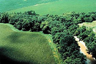
WA riparian zone or riparian area is the interface between land and a river or stream. Riparian is also the proper nomenclature for one of the terrestrial biomes of the Earth. Plant habitats and communities along the river margins and banks are called riparian vegetation, characterized by hydrophilic plants. Riparian zones are important in ecology, environmental resource management, and civil engineering because of their role in soil conservation, their habitat biodiversity, and the influence they have on fauna and aquatic ecosystems, including grasslands, woodlands, wetlands, or even non-vegetative areas. In some regions, the terms riparian woodland, riparian forest, riparian buffer zone, riparian corridor, and riparian strip are used to characterize a riparian zone. The word riparian is derived from Latin ripa, meaning "river bank".
 W
WIn geography, a bank is the land alongside a body of water. Different structures are referred to as banks in different fields of geography, as follows.
 W
WIn geomorphology, geography and geology, a bench or benchland is a long, relatively narrow strip of relatively level or gently inclined land that is bounded by distinctly steeper slopes above and below it. Benches can be of different origins and created by very different geomorphic processes.
 W
WA bosque is a type of gallery forest habitat found along the riparian flood plains of stream and river banks in the southwestern United States. It derives its name from the Spanish word for woodlands.
 W
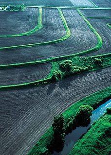
WA buffer strip is an area of land maintained in permanent vegetation that helps to control air, soil, and water quality, along with other environmental problems, dealing primarily on land that is used in agriculture. Buffer strips trap sediment, and enhance filtration of nutrients and pesticides by slowing down runoff that could enter the local surface waters. The root systems of the planted vegetation in these buffers hold soil particles together which alleviate the soil of wind erosion and stabilize stream banks providing protection against substantial erosion and landslides. Farmers can also use buffer strips to square up existing crop fields to provide safety for equipment while also farming more efficiently.
 W
WDaylighting can be defined as "“opening up buried watercourses and restoring them to more natural conditions". An alternative definition refers to "“the practice of removing streams from buried conditions and exposing them to the Earth's surface in order to directly or indirectly enhance the ecological, economic and/or socio-cultural well-being of a region and its inhabitants”. The term is used to refer to the restoration of an originally open-air watercourse, which had at some point been diverted below ground, back into an above-ground channel. Typically, the rationale behind returning the riparian environment of a stream, wash, or river to a more natural state is to reduce runoff, create habitat for species in need of it, or improve an area's aesthetics. In the UK, the practice is also known as deculverting.
 W
WDesert riparian is a North American desert vegetation type occurring in the bottoms of canyons and drainages that have water at or near the surface most of the year. It is contrasted with the desert dry wash vegetation type in which water at or near the surface is lacking most of the year. The visual character is of large, lush green trees surrounded by dry desert vegetation and soil coloration. The area may be in a patch surrounding a spring (oasis), or in a strand following the course of water flow. Over 80% of known desert wildlife species use desert riparian areas. Common dominant species include Fremont cottonwood, Arizona ash, arroyo willow, Goodding's willow, red willow, California fan palm, and invasive species such as salt cedar, giant reed, and Russian olive. Salt cedar is particularly causing problems for this ecosystem because it is able to extract water more efficiently than cottonwoods and willows. Many noninvasive non-native species may also be found because springs and surface water areas in the desert often were old homesites where such species were intentionally planted, such as elm, black locust, and assorted fruit trees.
 W
WErosion control is the practice of preventing or controlling wind or water erosion in agriculture, land development, coastal areas, river banks and construction. Effective erosion controls handle surface runoff and are important techniques in preventing water pollution, soil loss, wildlife habitat loss and human property loss.
 W
WA flood-meadow is an area of grassland or pasture beside a river, subject to seasonal flooding. Flood-meadows are distinct from water-meadows in that the latter are artificially created and maintained, with flooding controlled on a seasonal and even daily basis.
 W
WA gallery forest is one formed as a corridor along rivers or wetlands, projecting into landscapes that are otherwise only sparsely treed such as savannas, grasslands, or deserts.
 W
WA high water mark is a point that represents the maximum rise of a body of water over land. Such a mark is often the result of a flood, but high water marks may reflect an all-time high, an annual high or the high point for some other division of time. Knowledge of the high water mark for an area is useful in managing the development of that area, particularly in making preparations for flood surges. High water marks from floods have been measured for planning purposes since at least as far back as the civilizations of ancient Egypt. It is a common practice to create a physical marker indicating one or more of the highest water marks for an area, usually with a line at the level to which the water rose, and a notation of the date on which this high water mark was set. This may be a free-standing flood level sign or other marker, or it may be affixed to a building or other structure that was standing at the time of the flood that set the mark.
 W
WThe Audubon Kern River Preserve is a riparian nature reserve owned by the National Audubon Society in the US state of California, near Weldon in Kern County.
 W
WLand reclamation, usually known as reclamation, and also known as land fill, is the process of creating new land from oceans, seas, riverbeds or lake beds. The land reclaimed is known as reclamation ground or land fill.
 W
WA levee, dike, dyke, embankment, floodbank or stopbank is an elongated naturally occurring ridge or artificially constructed fill or wall that regulates water levels. It is usually earthen and often parallel to the course of a river in its floodplain or along low-lying coastlines.
 W
WA paddy field is a flooded field of arable land used for growing semiaquatic crops, most notably rice and taro. It originates from the Neolithic rice-farming cultures of the Yangtze River basin in southern China, associated with pre-Austronesian and Hmong-Mien cultures. It was spread in prehistoric times by the Austronesian expansion to Island Southeast Asia, Southeast Asia including Northeastern India, Madagascar, Melanesia, Micronesia, and Polynesia. The technology was also acquired by other cultures in mainland Asia for rice farming, spreading to East Asia, Mainland Southeast Asia, and South Asia.
 W
WA polder is a low-lying tract of land that forms an artificial hydrological entity, enclosed by embankments known as dikes. The three types of polder are:Land reclaimed from a body of water, such as a lake or the seabed Flood plains separated from the sea or river by a dike Marshes separated from the surrounding water by a dike and subsequently drained; these are also known as koogs, especially in Germany
 W
WIn stream restoration, river engineering or coastal engineering, revetments are sloping structures placed on banks or cliffs in such a way as to absorb the energy of incoming water. In military engineering they are structures, again sloped, formed to secure an area from artillery, bombing, or stored explosives. River or coastal revetments are usually built to preserve the existing uses of the shoreline and to protect the slope, as defense against erosion.
 W
WA riparian buffer or stream buffer is a vegetated area near a stream, usually forested, which helps shade and partially protect the stream from the impact of adjacent land uses. It plays a key role in increasing water quality in associated streams, rivers, and lakes, thus providing environmental benefits. With the decline of many aquatic ecosystems due to agriculture, riparian buffers have become a very common conservation practice aimed at increasing water quality and reducing pollution.
 W
WA riparian forest or riparian woodland is a forested or wooded area of land adjacent to a body of water such as a river, stream, pond, lake, marshland, estuary, canal, sink or reservoir.
 W
WRiparian-zone restoration is the ecological restoration of riparian-zone habitats of streams, rivers, springs, lakes, floodplains, and other hydrologic ecologies. A riparian zone or riparian area is the interface between land and a river or stream. Riparian is also the proper nomenclature for one of the fifteen terrestrial biomes of the earth; the habitats of plant and animal communities along the margins and river banks are called riparian vegetation, characterized by Aquatic plants and animals that favor them. Riparian zones are significant in ecology, environmental management, and civil engineering because of their role in soil conservation, their habitat biodiversity, and the influence they have on fauna and aquatic ecosystems, including grassland, woodland, wetland or sub-surface features such as water tables. In some regions the terms riparian woodland, riparian forest, riparian buffer zone, or riparian strip are used to characterize a riparian zone.
 W
WRiver ecosystems are flowing waters that drain the landscape, and include the biotic (living) interactions amongst plants, animals and micro-organisms, as well as abiotic (nonliving) physical and chemical interactions of its many parts. River ecosystems are part of larger watershed networks or catchments, where smaller headwater streams drain into mid-size streams, which progressively drain into larger river networks.
 W
WRiver engineering is the process of planned human intervention in the course, characteristics, or flow of a river with the intention of producing some defined benefit. People have intervened in the natural course and behaviour of rivers since before recorded history—to manage the water resources, to protect against flooding, or to make passage along or across rivers easier. From Roman times, rivers have been used as a source of hydropower. From the late 20th century, river engineering has had environmental concerns broader than immediate human benefit and some river engineering projects have been concerned exclusively with the restoration or protection of natural characteristics and habitats.
 W
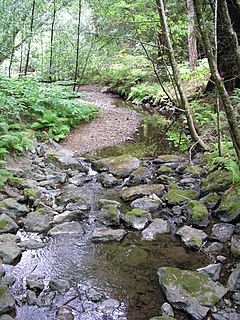
WA stream bed or streambed is the channel bottom of a stream or river, the physical confine of the normal water flow. The lateral confines or channel margins are known as the stream banks or river banks, during all but flood stage. Under certain conditions a river can branch from one stream bed to multiple stream beds. A flood occurs when a stream overflows its banks and flows onto its flood plain. As a general rule, the bed is the part of the channel up to the normal water line, and the banks are that part above the normal water line. However, because water flow varies, this differentiation is subject to local interpretation. Usually, the bed is kept clear of terrestrial vegetation, whereas the banks are subjected to water flow only during unusual or perhaps infrequent high water stages and therefore might support vegetation some or much of the time.
 W
WStream restoration or river restoration, also sometimes referred to as river reclamation, is work conducted to improve the environmental health of a river or stream, in support of biodiversity, recreation, flood management and/or landscape development. Stream restoration approaches can be divided into two broad categories: form-based restoration, which relies on physical interventions in a stream to improve its conditions; and process-based restoration, which advocates the restoration of hydrological and geomorphological processes to ensure a stream's resilience and ecological health. Form-based restoration techniques include deflectors; cross-vanes; weirs, step-pools and other grade-control structures; engineered log jams; bank stabilization methods and other channel-reconfiguration efforts. These induce immediate change in a stream, but sometimes fail to achieve the desired effects if degradation originates at a wider scale. Process-based restoration includes restoring lateral or longitudinal connectivity of water and sediment fluxes and limiting interventions within a corridor defined based on the stream's hydrology and geomorphology. The beneficial effects of process-based restoration projects may sometimes take time to be felt since changes in the stream will occur at a pace that depends on the stream dynamics.
 W
WIn geology, a terrace is a step-like landform. A terrace consists of a flat or gently sloping geomorphic surface, called a tread, that is typically bounded on one side by a steeper ascending slope, which is called a "riser" or "scarp". The tread and the steeper descending slope together constitute the terrace. Terraces can also consist of a tread bounded on all sides by a descending riser or scarp. A narrow terrace is often called a bench.
 W
WTugay is a form of riparian forest or woodland associated with fluvial and floodplain areas in arid climates. These wetlands are subject to periodic inundation, and largely dependent on floods and groundwater rather than directly from rainfall. Tugay habitats occur in semi-arid and desert climates in central Asia. Because Tugay habitat is usually linear, following the courses of rivers in arid landscapes, Tugay communities often function as wildlife corridors. They have disappeared or become fragmented over much of their former range.
 W
WUpland and lowland are conditional descriptions of a plain based on elevation above sea level. In studies of the ecology of freshwater rivers, habitats are classified as upland or lowland.
 W
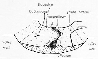
WA Yazoo stream is a geologic and hydrologic term for any tributary stream that runs parallel to, and within the floodplain of a larger river for considerable distance, before eventually joining it. This is especially the characteristic when such a stream is forced to flow along the base of the main river's natural levee. Where the two meet is known as a "belated confluence" or a "deferred junction". The name is derived from an exterminated Native American tribe, the Yazoo Indians. The Choctaw word is translated to "River of Death" because of the strong flows under its bank full stage.