 W
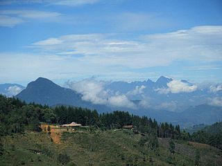
WAlto de Nique is a mountain in South and Central America. It is 1,730 metres (5,676 ft) tall and sits on the international border between Colombia and Panama.
 W
WAzufral is a stratovolcano located in the department of Nariño in southern Colombia, 12 km (7 mi) west of the town of Túquerres. It is the only volcano of the Western Ranges of the Colombian Andes. Its name derives from the Spanish word for sulfur, azufre. The volcano is considered semi-dormant but there are numerous fumaroles in the summit crater. The summit of the volcano has an altitude of 4,070 metres (13,350 ft), and the north-western side of the crater contains a crescent-shaped lake named Laguna Verde at 3,970 m (13,025 ft). The lake is 1,100 m (0.68 mi) long and 600 metres (2,000 ft) wide. and its bright green color is a result of the sulfur and iron-based deposits in the crater. There are also two other much smaller lakes in the crater, Laguna Negra and Laguna Cristal.
 W
WCerro Bravo is a stratovolcano located in Tolima, Colombia, north of the Nevado del Ruiz volcano. The rock type of the volcano is andesite.
 W
WCerro Machín is a stratovolcano located in Tolima Department, Colombia. Cerro Machin is a volcanic plug that is approximately the same age as the Ruiz-Tolima Massif and has the appearance of being part of that volcanic system. Its sisters are Nevado del Tolima, 17,060 feet (5,200 m); Santa Isabel, 16,240 feet (4,950 m), Nevado del Ruiz, 17,457 feet (5,321 m), plus nine other lesser volcanoes and a 10,000 feet (3,000 m) volcanic South Wall containing in excess of thirty volcanic domes.
 W
WChiles is a volcano on the border of Colombia and Ecuador. It lies 3 kilometres (2 mi) south-east of the volcano Cerro Negro de Mayasquer, and the two peaks are considered part of the same Chiles-Cerro Negro volcanic complex. The volcanoes, together with the Cumbal are andesitic in rock type. A 1936 eruption reported by the Colombian government agency Ingeominas may have been from the Ecuadorean volcano Reventador, otherwise the volcano has not erupted for around 160,000 years.
 W
WThe Colombian Massif, also known colloquially as Nudo de Almaguer, refers to a group of mountains within the Andes of south central Colombia. The massif is mainly within the area of the Cauca, Huila, and Nariño Departments. To the south is the Pasto Massif and to the north begins the Central and Eastern Andes.
 W
WPico Cristóbal Colón is the highest mountain in Colombia, with an estimated height of 5,730 metres (18,800 ft). Pico Cristóbal Colón and Pico Simón Bolívar are the two highest peaks in Colombia and are very nearly equal in elevation.. One or other of these peaks is therefore the fifth most prominent in the world. The nearest peak that is higher is Cayambe, some 1,288 kilometres (800 mi) away. There is a permanent snowcap on this peak and on the nearby mountains. It is part of the Sierra Nevada de Santa Marta range, along with Pico Simón Bolívar. The peak is named after Christopher Columbus.
 W
WCumbal is a stratovolcano of the Caribe Terrane, located at the Nudo de los Pastos in Nariño, Colombia. It is the southernmost historically active volcano of Colombia and is together with Chiles and Azufral one of the few volcanoes of the Western Ranges. The volcano is dominated by andesites.
 W
WDoña Juana is a stratovolcano, located within the Doña Juana-Cascabel Volcanic Complex National Natural Park in Nariño, Colombia.
 W
WEl Escondido is a volcano of the Central Ranges of the Colombian Andes in the department of Caldas. The volcano is approximately 1,700 metres (5,600 ft) high.
WFarallones de Cali is a cluster of mountains in the West Andes of Colombia. It is located west of the city of Cali and gives rise to many of the rivers that provide water and electricity to Cali. The PNN Farallones de Cali encompasses 150,000 ha (580 sq mi) in the mountains as well as much of the Pacific slope and is an area of very high biodiversity. The average temperature ranges from 25 °C (77 °F) in the tropical foothills to 5 °C (41 °F) in the páramo.
 W
WThe Farallones del Citará are situated in the mountains of southwest Antioquia, Colombia, only miles from the border with neighboring Chocó. The area contains two rivers, the Citará river and the Atrato river.
 W
WGaleras is an Andean stratovolcano in the Colombian department of Nariño, near the departmental capital Pasto. Its summit rises 4,276 metres (14,029 ft) above sea level. It has erupted frequently since the Spanish conquest, with its first historical eruption being recorded on December 7, 1580. A 1993 eruption killed nine people, including six scientists who had descended into the volcano's crater to sample gases and take gravity measurements in an attempt to be able to predict future eruptions. It is currently the most active volcano in Colombia.
WLas Ánimas is a volcano of the Central Ranges of the Colombian Andes at the border of the departments of Cauca and Nariño. The volcano is 4,175 metres (13,698 ft) high.
 W
WCerro Negro de Mayasquer is a volcano on the border of Colombia and Ecuador. It lies 3 kilometres (2 mi) north-west of the volcano Chiles, and the two peaks are considered part of the same Chiles-Cerro Negro volcanic complex. These volcanoes, together with Cumbal are andesitic in rock type. A 1936 eruption reported by the Colombian government agency INGEOMINAS may have been from the Ecuadorean volcano Reventador, otherwise the volcano has not erupted for around 160,000 years.
 W
WNevado del Huila at 5,364 metres (17,598 ft), is the highest volcano in Colombia, located at the tripoint of the departments of Huila, Tolima and Cauca. It is visible from the city of Cali. The andesitic volcano is located on top of the Ibagué Batholith.
 W
WThe Nevado del Quindío is an inactive volcano located in the Central Cordillera of the Andes in central Colombia. The summit marks the tripoint of the departments of Risaralda, Quindío and Tolima, and is also the highest point of the departments of Risaralda and Quindío. The mountain is one of the highest peaks in the Los Nevados National Natural Park, which is a wildlife sanctuary. There are no historical records of any eruption. The andesitic volcano is located on top of the Palestina Fault.
 W
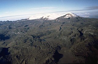
WThe Nevado del Ruiz, also known as La Mesa de Herveo is a volcano on the border of the departments of Caldas and Tolima in Colombia, about 129 kilometers (80 mi) west of the capital city Bogotá. It is a stratovolcano composed of many layers of lava alternating with hardened volcanic ash and other pyroclastic rocks. Volcanic activity at Nevado del Ruiz began about two million years ago, since the Early Pleistocene or Late Pliocene, with three major eruptive periods. The current volcanic cone formed during the present eruptive period, which began 150,000 years ago.
 W
WThe Nevado del Tolima is a Late Pleistocene to recently active andesitic stratovolcano located in the Tolima department, Colombia. The volcano lies south of Nevado del Ruiz volcano and is situated within the Los Nevados National Natural Park. The volcano, whose most recent activity dates to 1943 and last major eruption around 3600 years ago, overlies the Eocene El Bosque Batholith, dated at 49.1 ± 1.7 Ma.
WThe Nevado El Cisne is a volcano in the Central Ranges of the Andes in Colombia. Its summit is at an altitude of 4,636 metres (15,210 ft). The mountain is one of the five lava domes of the Nevado del Ruiz volcano complex. Despite the nevado part of the name, indicating a permanently snow-capped mountain, the summit of El Cisne is now below the permanent snow line as a result of global warming, and it is no longer considered a true nevado. The volcano is located over the Palestina Fault, that crosscuts the underlying El Bosque Batholith of Eocene age, dated at 49.1 ± 1.7 Ma.
WPetacas is a lava dome in the departments of Cauca and Nariño, Colombia.
 W
WCerro Pintado is a mountain in South America. It has an elevation 3,660 metres (12,008 ft) above sea level and sits on the international border between Colombia and Venezuela.
 W
WPuracé is an andesitic stratovolcano located in the Puracé National Natural Park in the Cauca Department, Colombia. It is part of the North Volcanic Zone of the Andean Volcanic Belt. The volcano is located at the intersection of the Coconucos and Morras Faults.
 W
WRitacuba Blanco is the highest peak of Cordillera Oriental, in the Andes Mountains of Colombia. It's also named Ritak'uwa, an ancient name from the U'wa indigenous people that live in the lowlands of the National Park Sierra Nevada del Cocuy y Güicán, where the Ritacuba Blanco is located. The summit is accessible from the west via the town of El Cocuy, the village of Güicán and the hamlet of Las Cabañas. The hike is fairly easy, but weather is not reliable, and a glacier must be crossed. Because of global warming, its glacier is melting at very high rates, backing down 25 linear mts per year; same is happening at amazing speeds to all other snow-covered tropical mountains in Colombia. In 1950, Ritacuba Blanco's glacier extended down to 4,500 metres (14,800 ft) above sea level; in January 2007 its lowest point was at 4,800 metres (15,700 ft) above sea level. If this melting rate continues, the glacier is expected to disappear before 2025.
WRomeral is a stratovolcano located in Caldas, Colombia. It is the northernmost Holocene volcano of South America, of the North Volcanic Zone in the Andean Volcanic Belt. The volcano was formed in the Late Pliocene, approximately 3 million years ago.
 W
WSanta Isabel is a shield volcano located in Tolima, Colombia, southwest of Nevado del Ruiz volcano. The volcano is located over the Palestina Fault, that crosscuts the underlying El Bosque Batholith of Eocene age, dated at 49.1 ± 1.7 Ma.
WPico Simón Bolívar is the second highest mountain in Colombia, with an estimated height of 5,730 metres (18,800 ft). Pico Bolívar and the neighbouring summit of Pico Cristóbal Colón are the two highest peaks in Colombia and are very nearly equal in elevation. The difference in elevation is estimated to be only one or two metres. One or other of these peaks is therefore the fifth most prominent in the world. The nearest peak that is higher is Cayambe, some 1,288 kilometres (800 mi) away. There is a permanent snowcap on this peak and on the nearby mountains. It is part of the Sierra Nevada de Santa Marta range, along with Pico Cristóbal Colón. The peak is named after Simón Bolívar.
 W
WSotará is a stratovolcano located in Cauca, Colombia. The volcano has hot springs of 80 °C (176 °F) and fumarole activity with a composition of 80% CO2 and 20% H2S. The volcano is located between the Silvia-Pijao Fault in the west and the San Jerónimo Fault in the east.