 W
WThe Arctic Lake Plateau is a lava plateau in northern British Columbia, Canada, located northeast of Arctic Lake at the south end of Mount Edziza Provincial Park and Recreation Area.
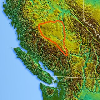
WThe Big Raven Plateau is a lava plateau in northern British Columbia, Canada, located west of Mount Edziza in Mount Edziza Provincial Park and Recreation Area. It is part of the Tahltan Highland, which is the southwestern sub-region of the Stikine Plateau.
 W
WThe Biu Plateau is a highland area in Northeastern Nigeria containing many recently extinct volcanoes. It covers about 5,200 km2 (2,000 sq mi) and has an average elevation of 700 m (2,300 ft). The plateau lies between the Upper Benue Basin to the south and the Chad Basin to the north. High points are Wade Hill at 775 m (2,543 ft) above sea level and Wiga Hill, at well over 800 m (2,600 ft). The plateau is the source of many tributaries of the Gongola River, which have cut deep gorges. To the north the plateau slopes gently to the Bauchi plains and the Chad Basin.
 W
WCaja del Rio is a dissected plateau, of volcanic origin, which covers approximately 84,000 acres of land in northern Santa Fe County, New Mexico, United States. The region is also known as the Caja, Caja del Rio Plateau, and Cerros del Rio. The center of the area is approximately 15 miles (23 km) west of Santa Fe, New Mexico. Most of the Caja is owned by the United States Forest Service and managed by the Santa Fe National Forest. Access is through New Mexico Highway 599, Santa Fe County Road 62, and Forest Service Road 24.
 W
WThe Cariboo Plateau is a volcanic plateau in south-central British Columbia, Canada. It is part of the Fraser Plateau that itself is a northward extension of the North American Plateau. The southern limit of the plateau is the Bonaparte River although some definitions include the Bonaparte Plateau between that river and the Thompson, but it properly is a subdivision of the Thompson Plateau. The portion of the Fraser Plateau west of the Fraser River is properly known as the Chilcotin Plateau but is often mistakenly considered to be part of the Cariboo Plateau, which is east of the Fraser.
 W
WThe Chilcotin Plateau is part of the Fraser Plateau, a major subdivision of the Interior Plateau of British Columbia. The Chilcotin Plateau is physically near-identical with the region of the same name, i.e. "the Chilcotin", which lies between the Fraser River and the southern Coast Mountains and is defined by the basin of the Chilcotin River and so includes montane areas beyond the plateau. East of the Chilcotin Plateau, across the Fraser River, is the Cariboo Plateau, while to the north beyond the West Road (Blackwater) River is the Nechako Plateau. West and south of the Chilcotin Plateau are various subdivisions of the Coast Mountains, including the Chilcotin Ranges which lie along the plateau's southwest.
WThe Dil-Dil Plateau is a small lava plateau on the west side of the upper valley of Big Creek in the southern Chilcotin District of the Central Interior of British Columbia. The plateau is a shelf-like extension of the subrange of the Chilcotin Ranges containing Taseko Mountain and Mount Vic to the west, and is roughly rectangular in shape, and of c.25–30 km2 in area and forming a transition between the range and the Chilcotin Plateau at 2000m-2300m.
 W
WThe Mount Edziza volcanic complex is a large and potentially active north-south trending complex volcano in Stikine Country, northwestern British Columbia, Canada, located 38 kilometres (24 mi) southeast of the small community of Telegraph Creek. It occupies the southeastern portion of the Tahltan Highland, an upland area of plateau and lower mountain ranges, lying east of the Boundary Ranges and south of the Inklin River, which is the east fork of the Taku River. As a volcanic complex, it consists of many types of volcanoes, including shield volcanoes, calderas, lava domes, stratovolcanoes, and cinder cones.
 W
WElysium, located in the Elysium and Cebrenia quadrangles, is the second largest volcanic region on Mars, after Tharsis. The region includes the volcanoes Hecates Tholus, Elysium Mons and Albor Tholus. The province is centered roughly on Elysium Mons at 24.7°N 150°E. Elysium Planitia is a broad plain to the south of Elysium, centered at 3.0°N 154.7°E. Another large volcano, Apollinaris Mons, lies south of Elysium Planitia and is not part of the province. Besides having large volcanoes, Elysium has several areas with long trenches, called fossa or fossae (plural) on Mars. They include the Cerberus Fossae, Elysium Fossae, Galaxias Fossae, Hephaestus Fossae, Hyblaeus Fossae, Stygis Fossae and Zephyrus Fossae.
 W
WThe Fraser Plateau is an intermontane plateau. It is one of the main subdivisions of the Interior Plateau located in the Central Interior of British Columbia.
 W
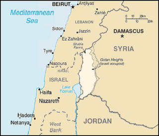
WThe Golan Heights, or simply the Golan, is a region in the Levant, spanning about 1,800 square kilometers (690 sq mi). The region defined as the Golan Heights differs between disciplines: as a geological and biogeographical region, the Golan Heights refers to a basaltic plateau bordered by the Yarmouk River in the south, the Sea of Galilee and Hula Valley in the west, the Anti-Lebanon with Mount Hermon in the north and Wadi Raqqad in the east. As a geopolitical region, the Golan Heights refers to the area captured from Syria and occupied by Israel during the 1967 Six-Day War, territory which has been administered as part of Israel since 1981. This region includes the western two-thirds of the geological Golan Heights and the Israeli-occupied part of Mount Hermon.
 W
WThe Hauran also spelled Hawran or Houran) is a region that spans parts of southern Syria and northern Jordan. It is bound in the north by the Ghouta oasis, eastwards by the al-Safa field, to the south by Jordan's desert steppe and to the west by the Golan Heights. Traditionally, the Hauran consists of three subregions: the Nuqrah and Jaydur plains, the Jabal al-Druze massif, and the Lajat volcanic field. The population of the Hauran is largely Arab, but religiously heterogeneous; most inhabitants of the plains are Sunni Muslims belonging to large agrarian clans, while Druze form the majority in the eponymous Jabal al-Druze and a significant Greek Orthodox and Greek Catholic minority inhabit the western foothills of Jabal al-Druze. The region's largest towns are Daraa, al-Ramtha and al-Suwayda.
 W
WHeart Peaks, originally known as the Heart Mountains, is a mountain massif in the Northern Interior of British Columbia, Canada. It is 90 km (56 mi) northwest of the small community of Telegraph Creek and just southwest of Callison Ranch. With a maximum elevation of 2,012 m (6,601 ft), it rises above the surrounding landscape on the Nahlin Plateau, which is part of the western Stikine Plateau. Heart Peaks has been an area of prospecting since the 1980s with the discovery of precious metals.
 W
WJavalkheti Plateau is a volcanic plateau within the Caucasus Mountains that covers the Samtskhe-Javakheti region of Georgia, along the border with Turkey and Armenia. Its elevation is over 2,000 m.
WThe Kitsu Plateau is a lava plateau in northern British Columbia, Canada, located east of Mess Lake in Mount Edziza Provincial Park and Recreation Area. It is named in association with Kitsu Peak and Kitsu Creek. Kitsu in the Tahltan language is the word for the northern lights.
 W
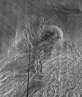
WLakshmi Planum is a plateau feature approximately 2 million sq km ringed by rugged mountains, the surface of Venus on the Western Ishtar Terra. It is named after Lakshmi, the Hindu goddess of wealth.
 W
WLetha Taung, also known as the Singu Plateau, is a small volcanic plateau in central Burma (Myanmar).
 W
WLevel Mountain is a massive complex volcano in the Northern Interior of British Columbia, Canada. It is located 50 km (31 mi) north-northwest of Telegraph Creek and 60 km (37 mi) west of Dease Lake on the Nahlin Plateau. With a maximum elevation of 2,166 m (7,106 ft), it is the third highest of five large complexes in an extensive north-south trending volcanic zone. Much of the mountain is gently-sloping; when measured from its base, Level Mountain is about 1,100 m (3,600 ft) tall, slightly taller than its neighbour to the northwest, Heart Peaks. The lower broader half of Level Mountain consists of a shield-like edifice while its upper half has a more steep, jagged profile. Its large summit is dominated by the Level Mountain Range, a small mountain range with prominent peaks cut by deep valleys. These valleys serve as a radial drainage for several small streams that flow from the volcano. Meszah Peak is the only named peak in the Level Mountain Range.
WThe Nechako Plateau is the northernmost subdivision of the Interior Plateau, one of the main geographic regions of the Canadian province of British Columbia. It spans the basin of the Nechako River and its tributaries the Stuart River and Endako Rivers, and is bounded on the south by the West Road River, south of which is the Chilcotin Plateau and on the north by the Nation River and the valleys of Babine and Takla Lakes, beyond which are the Omineca Mountains (N) and Skeena Mountains (NW). To the west, it abuts the various ranges of the Hazelton Mountains while on its east it is bounded by the pass between Prince George, British Columbia and the Parsnip Arm of Williston Lake, beyond which is the McGregor Plateau, which skirts the Northern Rockies. Some classification systems include the plateau area on the east bank of the Fraser River beyond the city of Prince George; this area neighbours the northernmost reaches of the Quesnel Highland and Cariboo Mountains.
 W
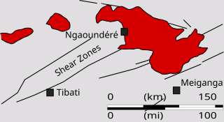
WThe Ngaoundéré Plateau is a highland area in the Adamawa Region of Cameroon. It contains Tchabal Nganha, a large volcano, and many other recent volcanic structures.
 W
WThe Putorana Plateau or the Putorana Mountains is a mountainous area in the Russian Federation. It is a large massif or plateau crossed by mountain ranges. The nearest large settlement is Norilsk, where foreign travel is restricted. The city is served by Alykel Airport.
 W
WThe Spatsizi Plateau is a plateau in the upper basin of the Stikine River in north-central British Columbia, Canada. Most of the plateau, which is a sub-plateau of the Stikine Plateau, is enshrined in either Spatsizi Plateau Wilderness Provincial Park or Spatsizi Headwaters Provincial Park. It is flanked on the south and southwest by the Skeena Mountains, on the southeast by the Omineca Mountains, on the northeast by the Stikine Ranges of the Cassiar Mountains, and on the west by the Klastline Plateau.
 W
WTamborine Mountain is a 28 km2 (11 sq mi) plateau and locality in the Scenic Rim Region of South East Queensland, Australia. The name is of Aboriginal origin and is frequently misspelt as Tambourine but neither the name nor the place has any connection to the musical instrument. It is considered part of the Gold Coast hinterland and has a strong tourist industry.
 W
WTharsis is a vast volcanic plateau centered near the equator in the western hemisphere of Mars. The region is home to the largest volcanoes in the Solar System, including the three enormous shield volcanoes Arsia Mons, Pavonis Mons, and Ascraeus Mons, which are collectively known as the Tharsis Montes. The tallest volcano on the planet, Olympus Mons, is often associated with the Tharsis region but is actually located off the western edge of the plateau. The name Tharsis is the Greco-Latin transliteration of the biblical Tarshish, the land at the western extremity of the known world.
 W
WTolmachev Dol is a volcanic highland located in the southern part of Kamchatka Peninsula, Russia, northeast of Opala volcano. The cones and lava fields cover a broad area around Lake Tolmachev.
 W
WThe Tsalka Plateau is a volcanic plateau in central Georgia, in the upper reaches of the Khrami River, roughly corresponding to the territory of the Tsalka Municipality and a small portion of the adjacent Borjomi Municipality. It is considered part of the greater Javakheti Plateau.
 W
WUpper Table Rock and Lower Table Rock are two prominent volcanic plateaus located just north of the Rogue River in Jackson County, Oregon, U.S. Created by an andesitic lava flow approximately seven million years ago and shaped by erosion, they now stand about 800 feet (240 m) above the surrounding Rogue Valley. The Table Rocks are jointly owned; The Nature Conservancy is responsible for 3,591 acres (1,453 ha), while the Bureau of Land Management is responsible for 1,280 acres (520 ha).
 W
WThe Wrangellia Terrane is a terrane extending from the south-central part of Alaska through southwestern Yukon and along the Coast of British Columbia in Canada. Some geologists contend that Wrangellia extends southward to Oregon, although this is not generally accepted.