 W
WThe Akatarawa Valley is a valley in the Tararua Range of New Zealand's North Island. It provides a link from the upper reaches of the Hutt Valley to Waikanae on the Kapiti Coast through rugged hill country. The valley is lowly populated and contains the localities of Reikorangi and Cloustonville. At the Hutt Valley end, the Akatarawa Valley is rugged and the Akatarawa River flows through it. The terrain is less difficult at the Kapiti end, where the Waikanae River flows through part of the valley on its route from its headwaters in the Tararuas to the Tasman Sea, and is met in the valley by tributaries such as the Ngatiawa River and the Reikorangi Stream.
 W
WThe Aorangi Range is a mountain range on the North Island of New Zealand. It is located in the Wairarapa region, extending more than 20 kilometres north from Cape Palliser, and is the southernmost mountain range on the island. The greater portion of these mountains are covered in native forest which is protected and set aside for public recreational use as part of the Aorangi Forest Park.
 W
WAotea Lagoon is an artificial lagoon surrounded by a 7-hectare (17-acre) public park in the Papakowhai suburb of Porirua, North Island, New Zealand. Aotea and two nearby lagoons were created when major arterial transport links were realigned from the natural coastline to land reclaimed from Porirua Harbour.
 W
WBirchville Dam is believed to be the second unreinforced concrete arch dam built for water supply in New Zealand. It was built in 1930 for the Upper Hutt Borough Council to provide increased water capacity for the borough and replaced a water supply weir built in 1913–1914 at the same location on Clarke's Creek, near Birchville. Decommissioned in 1958, when Upper Hutt joined the Wellington regional water scheme, this dam is now an historic attraction on the Cannon Point Walkway.
 W
WBreaker Bay is a suburb on the south east coast of Wellington City in New Zealand, on the Miramar Peninsula. The suburb contains a 600 m wide bay of the same name, and is part of the western shore of the Wellington Harbour entrance. The Eastern Walkway runs along the top of the Bay and has views of the area.
 W
WCook Strait is a strait that separates the North and South Islands of New Zealand. It connects the Tasman Sea on the northwest with the South Pacific Ocean on the southeast, and runs next to the capital city, Wellington. It is 22 kilometres (14 mi) wide at its narrowest point, and is considered one of the most dangerous and unpredictable waters in the world.
 W
WFitzroy Bay is a bay close to the entrance of Wellington Harbour in New Zealand. It lies to the southeast of the entrance to the harbour, between Pencarrow Head and Baring Head.
 W
WHoughton Bay and Valley is one of the southern suburbs of Wellington, New Zealand. It is located between Island Bay and Lyall Bay, on the rocky shores of the Cook Strait. It has two beaches, Houghton Bay and Princess Bay, used by surfers, swimmers and divers.
 W
WThe Hutt Valley is the large area of fairly flat land in the Hutt River valley in the Wellington region of New Zealand. Like the river that flows through it, it takes its name from Sir William Hutt, a director of the New Zealand Company in early colonial New Zealand.
 W
WIsland Bay is a coastal suburb of Wellington, the capital of New Zealand, situated 5 km south of the city centre.
 W
WThe Kapiti Coast is the name of the section of the coast of the south-western North Island of New Zealand that is north of Wellington and opposite Kapiti Island. It falls under the jurisdiction of the Wellington Regional Council.
 W
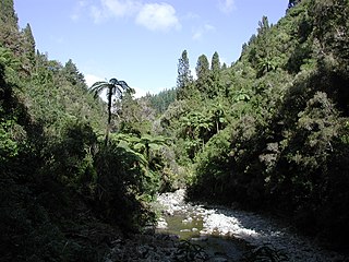
WKarapoti Gorge is one of the entrances into the Akatarawa Forest, a regional park in the Wellington Region in New Zealand. The Akatarawa River West runs through this narrow, mostly bush-clad gorge towards the Akatarawa Valley. A narrow road winds its way along the steep slopes, providing access for trail biking, mountain biking and walking. Karapoti Gorge is also the starting leg of the annual Karapoti Classic mountain bike event, which runs on the network of tracks in the Akatarawa Forest.
 W
WKupe's Sail is a geological formation near the eastern end of Palliser Bay at the southern end of the North Island of New Zealand.
 W
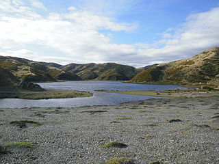
WLake Kohangapiripiri is one of the two freshwater Pencarrow lakes in Fitzroy Bay – the other being the slightly larger Lake Kohangatera. It stands to the east of Pencarrow Head, on the eastern side of New Zealand's Wellington Harbour, in East Harbour Regional Park, and is fed by Cameron Stream which rises on private land to its north. The Pencarrow lakes formed in valleys which became blocked to the nearby sea after earthquakes changed the topography.
 W
WLake Kohangatera is one of two lakes in Fitzroy Bay. It has an open water area of 17 hectares and is fed by Gollans Stream, which has its headwaters on Mount Lowry, 14 km to the north. The drainage basin area is about 1,700 ha.
 W
WLyall Bay is a bay and a suburb on the south side of the Rongotai isthmus in Wellington, New Zealand.
 W
WThe large Miramar Peninsula is on the southeastern side of the city of Wellington, New Zealand, at the entrance to Wellington Harbour, in Wellington's eastern suburbs. According to Māori legend, it was formed when the taniwha Whaitaitai beached as he tried to escape the confines of the harbour.
 W
WPalliser Bay is at the southern end of the North Island of New Zealand, to the southeast of Wellington. It runs for 40 kilometres along the Cook Strait coast from Turakirae Head at the southern end of the Rimutaka Ranges to Cape Palliser, the North Island's southernmost point.
 W
WPauatahanui Wildlife Reserve is a wetland reserve located in Pauatahanui and on the eastern edge of the Pauatahanui Inlet of the Porirua Harbour in Porirua, New Zealand.
 W
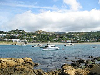
WTe Awarua-o-Porirua Harbour, commonly known as Porirua Harbour, is a natural inlet in the south-western coast of the North Island of New Zealand. The city of Porirua, one of the four cities in the Wellington conurbation, surrounds it. The city centre is to the south of the harbour. The harbour has an entrance only a few hundred metres in width, close to the suburb of Plimmerton. It opens up into two arms, Onepoto Arm to the south and Pauatahanui Arm to the north-east. Each arm is around three kilometres in length.
 W
WPrincess Bay is one of the southern beaches of Wellington, New Zealand.
 W
WThe Putangirua Pinnacles are a geological formation and one of New Zealand's best examples of badlands erosion. They consist of a large number of earth pillars or hoodoos located at the head of a valley in the Aorangi Ranges, on the North Island of New Zealand, in the Wellington region.
 W
WThe Remutaka Range is the southernmost range of a mountain chain in the lower North Island of New Zealand. The chain continues north into the Tararua, then Ruahine Ranges, running parallel with the east coast between Wellington and East Cape.
 W
WThe Tararua Range, often referred to as the Tararua Ranges or the Tararuas, is one of several mountain ranges in the North Island of New Zealand.
 W
WTaupo Swamp is an approximately 25-hectare (62-acre) lowland freshwater swamp, classified as a topogeneous mire, located three kilometres (1.9 mi) north of Plimmerton and 20 kilometres (12 mi) north-northeast of Wellington City, New Zealand. Taupo Swamp is home to largely indigenous vegetation including sedges, flax, ferns, shrubs, herbaceous plants, and grasses. The swamp is visible from State Highway 1 and the North Island Main Trunk railway.
 W
WTransmission Gully is a chain of steep-sided, isolated valleys in the Wellington Region of New Zealand, running approximately north-south between the Kapiti Coast and Tawa, through hills east of Porirua.
 W
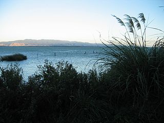
WLake Wairarapa is a lake at the southern end of the North Island of New Zealand, 50 kilometers east of Wellington. The lake covers an area of 78 km2 (30 sq mi), and at its deepest is 2.5 m (8.2 ft). The lake is the third largest in the North Island, fractionally smaller than Lake Rotorua. The nearest town to the lake is Featherston, which is located five kilometres from its northern shore.The lake forms part of the Wairarapa Moana Wetlands Park.
 W
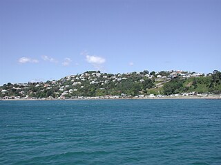
WWorser Bay in Wellington, New Zealand is along the beach from Seatoun and over the hill from Miramar on the Miramar Peninsula. It has a calm sandy beach with a road running along the base of the Seatoun Heights hill. Houses run all along the hill side of the road, with only carparks and beach facilities opposite.