 W
WAlistrati is a small town in Serres, situated at the borders of the regional unit of Drama and regional unit of Serres, in the Macedonia region of Greece. It has approximately 3,000 inhabitants, a town hall and a visitable cave. It is 20 km away from Drama and 45 km away from Serres. It is a listed traditional settlement and archaeologists had found something there. Since 2010 lAlistrati is part of the municipality New Zichni, of which it is a municipal unit. Alistrati town has a population of 2,127 (2011) while the municipal unit has an area of 129.878 km2 and a population of 3,088 (2011). Alistrati was built like an amphitheatrical inside a fascinating mountain groups on hills of the mountain range Menikio on an altitude of 325m. In Alistrati there exists rising and sloping streets. Sea-winds blowing from Thassos and Staymonikon Bay influence Alistrati day by day. Alistrati, a traditional community one of the biggest of the area Zichni-Fillida. It's been up-graded to municipality of Alistrati with the "Kapodistrias" law and included the villages :Agioxori, Skopia, Mandili, Lefkothea and R.S of Aggista.
 W
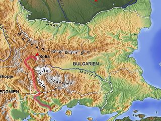
WBelasica, Belles or Kerkini, is a mountain range in the region of Macedonia in Southeastern Europe, shared by northeastern Greece, southeastern North Macedonia (35%) and southwestern Bulgaria (20%).
 W
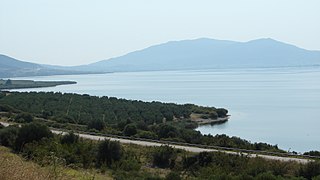
WDojran Lake, also spelled Doiran Lake is a lake with an area of 43.1 km2 (16.6 sq mi) shared between North Macedonia and Greece.
 W
WThe Elpeus is a river that stems from a ravine on the lower banks of Mount Olympus in Greece, located approximately five miles from the city of Dion.
 W
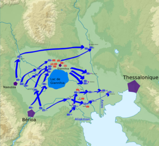
WGiannitsa Lake, also known as Lake Loudias is a former post-glacial lake in Central Macedonia, Greece, south of the town of Giannitsa. It was drained from 1928–1932. The plain of Roumlouki stretched to its south.
 W
WThe Haliacmon is the longest river in Greece, with a total length of 297 km (185 mi). In Greece there are three rivers longer than Haliakmon, Maritsa, Struma (Strymónas), both coming from Bulgaria, and Vardar, but the length of each one of them in Greek territory is less than that of Haliakmon, which flows entirely in Greece. Haliacmon is the traditional English name for the river, but many sources cite the formerly official Katharevousa version of the name, Aliákmon. Today, the only official variant is the demotic Aliákmonas. It flows through the Greek regions of West Macedonia and Central Macedonia.
 W
WKassandra (Κασσάνδρα) or Kassandra Peninsula is a peninsula and a municipality in Chalkidiki, Greece. The seat of the municipality is in Kassandreia.
 W
WLake Koroneia is a lake in the heart of the Thessaloniki regional unit in the Mygdonian basin in Greece. It is also known as Lake Agios Vasileios after the village Agios Vasileios and as Lake Langadas after the town Langadas, and is located about 14 kilometres east of Thessaloniki city centre. The motorway Egnatia Odos passes along the north side of the lake, and the old Greek National Road 2 passes along the south side. The lake is shared by the municipalities Langadas and Volvi.
 W
WLake Kerkini, is an artificial reservoir in Central Macedonia, Greece that was created in 1932, and then redeveloped in 1980, on the site of what was previously an extremely extensive marshland.
 W
WLake Vegoritida, also known in the past as Lake Ostrovo, is a large natural lake in western Macedonia, northern Greece. It is situated 6 km northeast of Amyntaio and 18 km west of Edessa, at 540 m elevation. The Voras Mountains lie to the north. It belongs partly to the Florina Prefecture and partly to the Pella Prefecture.
 W
WLake Volvi is located in the root of the Chalkidiki peninsula, in the Thessaloniki regional unit of Greece. It is the second largest lake in the country at 12 miles (19 km) in length, and 6 or 8 miles wide. The area is 68 km² and the depth is 20 m. It is located east of Lake Koroneia.
 W
WThe Loudias or Lydias (Λυδίας), popularly called Mavroneri is a river in Central Macedonia that flows through the regional units of Pella and Thessaloniki.
 W
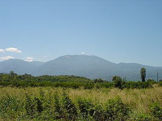
WMenoikio is a mountain range in the eastern Serres and western Drama regional units in Greece. The highest peak of the mountain is Mavromata at 1,963 m.
 W
WThe Moglenitsas is a river in Almopia, northern Greece. The river has its headwater in the Vermio Mountains of Greece and Macedonia and it flows into the Aliakmonas River near Kouloura, between Veria and Alexandreia, twenty kilometers west of Thessaloniki.
 W
WMountain Paiko or Pajak in Bulgarian and Macedonian is a small mountain range that lies on the border of the Pella and Kilkis regional units in Central Macedonia, Greece.
 W
WNeoi Poroi is a coastal village of the Dio-Olympos municipality. Before the 2011 local government reform it was part of the municipality of East Olympos, of which it was a municipal district. The settlement of Neoi Poroi had a population of 733 inhabitants as of 2011. Neoi Poroi is a part of the community of Poroi. The main occupation in the village is tourism. A model development plan, has huge streets and squares.
 W
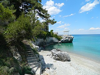
WOlympiaki Akti has translation into English as Olympic Beach, Olympic Coast, also still domestically known with its initial name Katerinoskala which can be literally expressed as "Katerini's staircase" gets its name from the Greek tradition that it refers to a seaside village closer to a city has a compound name (portmanteau) featuring the city name and the word skala or scala (staircase) which together form one name.
 W
WParalia Panteleimonos is a settlement of the former municipal district of Panteleimonas, the former municipality of East Olympos, which belongs to the municipality of Dio-Olympos, and is one of the 16 total coast of the regional unit.
 W
WThe Petralona cave also Cave of the Red Stones, a karst formation, is located at 300 m (984 ft) above sea-level on the western foot of Mount Katsika, about 1 km (0.62 mi) east of the village of Petralona, about 35 km (22 mi) south-east of Thessaloniki city on the Chalkidiki peninsula, Greece. The site came to public attention when in 1960 a fossilized archaic human skull was found. The cave had been discovered accidentally only a year earlier (1959) after erosion had left clefts in the rock. "Bejeweled" with impressive stalactite and stalagmite formations and holding an abundance of fossils, the cave soon attracted geologists and paleontologists. After decades of excavations the cave is open to the public and scientific work is documented and presented in an adjacent archaeological museum.
 W
WThe Pierian Mountains are a mountain range between Imathia, Pieria and Kozani Region, south of the plain of Kambania in Central Macedonia, Greece. The village of Vergina, where the archaeological site of ancient Aigai lies, is built at the foot of these mountains. The highest point in the range is Flampouro at 2,193m .The Pierian Mountains are the site of the ski resort of Elatochori.
 W
WPlatamon, or Platamonas, is a town and sea-side resort in south Pieria, Central Macedonia, Greece. Platamon has a population of about 2,000 permanent inhabitants. It is part of the Municipal unit of East Olympos of the Dio-Olympos municipality.
 W
WThe Struma or Strymónas is a river in Bulgaria and Greece. Its ancient name was Strymṓn. Its drainage area is 17,330 km2 (6,690 sq mi), of which 10,797 km2 (4,169 sq mi) in Bulgaria, 6,295 km2 (2,431 sq mi) in Greece and the rest in North Macedonia. It takes its source from the Vitosha Mountain in Bulgaria, runs first westward, then southward, forming a number of gorges, enters Greek territory at the Kula village. In Greece it is the main waterway feeding and exiting from Lake Kerkini, a significant centre for migratory wildfowl. The river flows into the Strymonian Gulf in Aegean Sea, near Amphipolis in the Serres regional unit. The river's length is 415 kilometres (of which 290 kilometres in Bulgaria, making it the country's fifth-longest and one of the longest rivers that run solely in the interior of the Balkans.
 W
WThe Strymonian or Strymonic Gulf, also known as the Orfano Gulf, is a branch of the Thracian Sea—itself part of the Aegean Sea—lying east of the Chalcidice peninsula and south of the Serres regional unit. It was formerly known as the Gulf of Rendina, in reference to the ancient colony of Eion along the gulf's shores.
 W
WThe Thermaic Gulf, also called the Gulf of Salonika and the Macedonian Gulf, is a gulf constituting the northwest corner of the Aegean Sea. The city of Thessaloniki is at its northeastern tip, and it is bounded by Pieria and Imathia on the west and the Chalkidiki peninsula on the east, with Cape Kassandra at the southeasternmost corner. It is named after the ancient town of Therma, modern Thessaloniki. It is about 100 km (62 mi) long.
 W
WThe Vardar or Axios is the longest river in North Macedonia and the second longest river in Greece. It is 388 km (241 mi) long, out of which 76 km are in Greece, and drains an area of around 25,000 km2 (9,653 sq mi). The maximum depth of the river is 4 m (13 ft).
 W
WThe Vermio Mountains, the ancient Bermion, is a mountain range in northern Greece. It lies between the Imathia Regional Unit of the Central Macedonia Region and the Kozani Regional Unit of the Western Macedonia Region. The range is west of the plain of Kambania. The town of Veria, which is the capital of Imathia, is built on the foot of these mountains. The highest point in the range is the peak Chamiti, 2,065 metres (6,775 ft) elevation, west of Naousa.
 W
WThe Voras Mountains, also known as Nidže are a mountain range situated on the border between Greece and North Macedonia. It separates the Pella regional unit on the Greek side in the south from the Mariovo region on the North Macedonia side in the north. The tallest peak in the range is Kaimakchalan at 2,524 m (8,281 ft). Adjacent peaks are Starkov grob and Dobro Pole.
 W
WVrontous is a mountain range in the northeastern Serres and the westernmost Drama regional units in Greece. Its highest peak is the Ali Babas at 1,849 m elevation. Other notable peaks are the Kour Lof, Mavro vouno, Siderovouni and Sarligia. It is a densely forested and sparsely populated mountain range. It stretches between the village Vamvakofyto in the southwest and Perithori in the northeast, over a length of about 35 km. The nearest mountains are the Slavyanka/Orvilos to the north and the Menoikio to the southeast.