 W
WThis is a list of active and extinct volcanoes in Mexico.
 W
WAjusco is a 3,930 m (12,894 ft) lava dome volcano located just south of Mexico City, Mexico, in the Tlalpan borough of the city. It is the highest point in the city.
 W
WCeboruco is a dacitic stratovolcano located in Nayarit, Mexico, northwest of the Trans-Mexican Volcanic Belt. The largest eruption, the Jala Plinian eruption, was around 930 AD ±200, VEI 6, releasing 11 cubic kilometres (2.6 cu mi) of tephra. The most recent and best documented eruption from Ceboruco lasted from 1870–1875, with fumarole activity lasting well into the 20th century. The mountain features one large caldera, created during the Jala eruption, with a smaller crater nested inside that formed when the Dos Equis lava dome collapsed during the Coapales eruption around 1100 AD. Within both of these craters, are several explosive volcanic features, including scoria deposits, lava domes, and pyroclastic domes, or cinder cone volcanoes.
 W
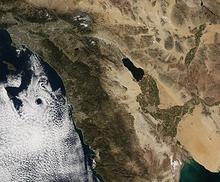
WCerro Prieto is a volcano located approximately 29 km (18 mi) SSE of Mexicali in the Mexican state of Baja California. The volcano lies astride a spreading center associated with the East Pacific Rise. This spreading center is also responsible for a large geothermal field which has been harnessed to generate electric power by the Cerro Prieto Geothermal Power Station.
 W
WDurango volcanic field is a volcanic field in north-central Mexico, east of the Sierra Madre Occidental. The field covers a surface area of 2,100 square kilometres (810 sq mi).
 W
WEl Chichón, also known as Chichonal, is an active volcano in Francisco León, north-western Chiapas, Mexico. El Chichón is part of a geologic zone known as the Chiapanecan Volcanic Arc. El Chichón is a complex of domes with a tuff ring, made of ejected volcanic material, located between the Trans-Mexican Volcanic Belt and the Central America Volcanic Arc. El Chichón erupted in 1982; prior to this, activity had not occurred since c.1360, although debates in literature occur around an eruption occurring in c.1850.
 W
WEl Elegante is a maar located in the Gran Desierto de Altar in the Sonoran Desert, Mexico.
 W
WEl Jorullo is a cinder cone volcano in Michoacán, central Mexico, on the southwest slope of the central plateau, 33 miles southeast of Uruapan in an area known as the Michoacán-Guanajuato volcanic field. It is about 6 miles (10 km) east-northeast of La Huacana. Its current elevation is 4,360 ft (1,329 m). El Jorullo has four smaller cinder cones which have grown from its flanks. The vents of El Jorullo are aligned in a northeast to southwest direction. Lava from these vents cover nine square km around the volcano. Later eruptions produced lavas that had higher silica contents making them thicker than the earlier basalts and basaltic andesite lavas. El Jorullo's crater is about 1,300 by 1,640 feet wide and 490 feet (150 m) deep.
 W
WGreen Seamount is a small seamount off the western coast of Mexico. It and the nearby Red Seamount were visited in 1982 by an expedition using DSV Alvin, which observed the seamount's sedimentary composition, sulfur chimneys, and biology. Thus, Green Seamount is well-characterized for such a small feature.
 W
WGuadalupe Island or Isla Guadalupe is a volcanic island located 241 kilometres (150 mi) off the west coast of Mexico's Baja California Peninsula and about 400 kilometres (249 mi) southwest of the city of Ensenada in the state of Baja California, in the Pacific Ocean.
WIsla Coronado, also known as “Smith Island” on some maps, is just off the eastern shoreline of Mexico's Baja California Peninsula, near Bahía de los Ángeles, in the Gulf of California. The island is approximately 7 kilometers long, and it is dominated by a volcano on its northern end. It is part of the Ensenada Municipality.
 W
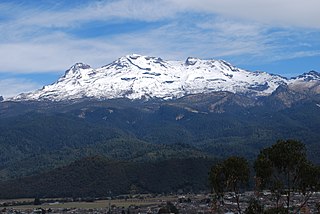
WIztaccíhuatl, is a 5,230 m (17,160 ft) dormant volcanic mountain in Mexico located on the border between the State of Mexico and Puebla within Izta-Popo Zoquiapan National Park. It is the nation's third highest, after Pico de Orizaba at 5,636 m (18,491 ft), and Popocatépetl at 5,426 m (17,802 ft).
 W
WThe Oriental Basin, also known as the Libres-Oriental Basin, Oriental-Serdán Basin or San Juan Plains is an endorheic basin in east-central Mexico. It covers an area of 4,958.60 square kilometers, lying in the states of Puebla, Tlaxcala, and Veracruz.
 W
WLos Atlixcos is a volcano in Veracruz, Mexico.
 W
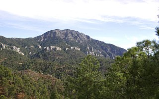
WLa Malinche, also known as Matlalcueye or Malintzin, is an active volcano located in the states of Tlaxcala and Puebla in Mexico. Officially, its summit reaches 4,461 metres (14,636 ft) above sea level, though it is generally considered to be closer to 4,440 metres (14,567 ft), using GPS measurements. It is the highest peak in Tlaxcala, the fifth-highest in Puebla, the sixth-highest in Mexico, the 23rd-highest in North America, and the 252nd-highest in the world. Its height above nearby cities varies from 1,908 metres (6,260 ft) above Huamantla, 2,461 metres (8,074 ft) above Villa Vicente Guerrero, 2,221 metres (7,287 ft) above Tlaxcala, to 2,299 metres (7,543 ft) above Puebla. The summit is 22.4 kilometres (13.9 mi) from Tlaxcala, 28.3 kilometres (17.6 mi) from Puebla, and 118 kilometres (73 mi) from Mexico City. The climate is cold near the summit and mild on the lower slopes.
 W
WMichoacán–Guanajuato volcanic field is located in central Mexico. It is a volcanic field that takes the form of a large cinder cone field, with numerous shield volcanoes and maars.
 W
WCerro Mohinora is an extinct volcano that is part of the Sierra Madre Occidental mountain range in the Mexican state of Chihuahua located in the municipality of Guadalupe y Calvo. Cerro Mohinora is the highest point in the state of Chihuahua reaching an elevation of 10,827 ft above sea level. The climate of the mountain is extremely cold in the winter and temperate to semi-cold in the summer.
 W
WNaolinco volcanic field is a volcanic field in Veracruz, Mexico. It lies in the region of the cities of Jalapa and Naolinco, and the town of Naolinco lies in the field.
 W
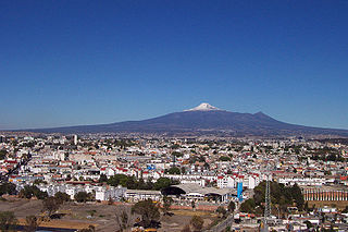
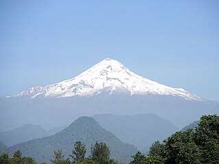
WPico de Orizaba, also known as "Citlaltépetl", is an inactive stratovolcano, the highest mountain in Mexico and the third highest in North America, after Denali of Alaska in the United States and Mount Logan of Canada. Pico de Orizaba is also the highest volcanic summit in North America. It rises 5,636 metres (18,491 ft) above sea level in the eastern end of the Trans-Mexican Volcanic Belt, on the border between the states of Veracruz and Puebla. The volcano is currently dormant but not extinct, with the last eruption taking place during the 19th century. It is the second most prominent volcanic peak in the world after Africa's Mount Kilimanjaro.
 W
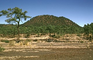
WParícutin is a cinder cone volcano located in the Mexican state of Michoacán, near the city of Uruapan and about 322 kilometers (200 mi) west of Mexico City. The volcano surged suddenly from the cornfield of local farmer Dionisio Pulido in 1943, attracting both popular and scientific attention.
 W
WThe Pinacate Peaks are a group of volcanic peaks and cinder cones located mostly in the Mexican state of Sonora along the international border adjacent to the U.S. state of Arizona, surrounded by the vast sand dune field of the Gran Desierto de Altar, at the desert's southeast.
 W
WThe Revillagigedo Islands or Revillagigedo Archipelago are a group of four volcanic islands in the Pacific Ocean, known for their unique ecosystem. They lie approximately 285 miles (458 km) from Socorro Island south and southwest of Cabo San Lucas, the southern tip of the Baja California Peninsula, and 698 to 1,092 kilometres west of Manzanillo. They are located around 18°49′N 112°46′W. Technically part of the Mexican state of Colima, the islands are under Mexican federal jurisdiction.
 W
WRocas Alijos, or Escollos Alijos are a group of tiny, steep and barren volcanic islets or above-water rocks in the Pacific Ocean at 24°57′31″N 115°44′59″W. They are part of Comondú municipality of the Mexican state of Baja California Sur, and situated about 300 kilometres (190 mi) west of the mainland. The total surface area is less than 1,000 square metres (11,000 sq ft). The official area figure of 0.012 square kilometres (0.0046 sq mi).
 W
WThe Sierra Chichinautzin volcanic field, also known as El Pedegral, is located in the Trans-Mexican Volcanic Belt, approximately 350 kilometres (220 mi) from where the Cocos Plate subducts beneath the North American Plate.
 W
WTres Vírgenes is a complex of volcanoes located Mulegé Municipality in the state of Baja California Sur, on the Baja California Peninsula in northwestern Mexico. This Volcano is apart of a volcanic ridge that extends from Baja California towards the Guaymas Basin.
 W
WThe volcanoes of east-central Baja California are located on the Baja California Peninsula near the Gulf of California, in the state of Baja California Sur, in Mexico.
 W
WXitle is a monogenetic volcano in the Ajusco range in Cumbres del Ajusco National Park. It is located in the Tlalpan borough in the southwestern part of Mexico City. It is an ash cone volcano with a conical form, round base, altitude of approximately 300m, and a slope between 30° and 40°.