 W
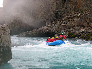
WOn an island like Iceland, the rivers are short in length. None of the rivers are important as a means of navigation due to the impracticality of settlements in the Highlands of Iceland where they originate.
 W
WAndakilsá is a river in West Iceland (Vesturland).
 W
WAustari-Jökulsá is a glacial river in the north of Iceland. After the confluence with Vestari-Jökulsá it forms the Héraðsvötn.
 W
WBerufjarðará is a river in the East Fjords region of Iceland.
 W
WThe Brúará is a river of Iceland. It is fed by springs and discharges at the Rotarsandur Area and the Brúará Canyons. It is a right tributary of the Hvítá. The whole river course is designated as a nature protected area.
 W
WThe river Elliðaár is situated in the Reykjavík area in the south-west of Iceland. Two small rivers have their source in the volcanic mountain range of Bláfjöll and stream down to Elliðavatn lake at the eastern suburban border of the city, its outlet forming the river. On their way, they pass through the nature reserve area of Heiðmörk.
 W
WThe best known valley Fossárdalur in Iceland runs from the direction of Þingvellir into the southern side of Hvalfjörður.
 W
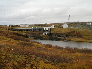
WThe Glerá River is a river in northern Iceland. It originates from glaciers in the mountains of the Tröllaskagi peninsula and also draws from some freshwater springs on its way down Glerá Valley. It runs through the town of Akureyri before it flows into the sea in Eyjafjörður. The river formed the sandbank of Oddeyri where it enters the sea. It was important in the dawn of the industrial age in Akureyri when it was dammed and used to produce electricity from 17 September 1922. The original power station has been demolished now but the dam remains. A new power station has been built to commemorate 100 years of hydroelectric power in Iceland. This 290 kW power station was opened on August 27, 2005.
 W
WHéraðsvötn is a river in Iceland. It is formed by the confluence of Austari-Jökulsá and Vestari-Jökulsá.
 W
WHvítá is a river in Iceland that begins at the Hvítárvatn glacier lake on the Langjökull glacier in the highlands of Iceland at 64°37′N 19°50′W. The river flows for 40 kilometres (25 mi) before dropping down into a narrow gorge at the Gullfoss waterfall.
 W
WJökulsá á Breiðamerkursandi is a river in Southeast Iceland in Austur-Skaftafellssýsla in the middle of Breiðamerkursandur, a glacial outwash plain.
 W
WJökulsá á Dal, also called Jökulsá á Brú or Jökla, is a river in the northeast of Iceland.
 W
WJökulsá á Fjöllum is the second longest river in Iceland (206 km). Its source is the Vatnajökull glacier. It flows into the Greenland Sea. Jökulsá á Fjöllum streams over the waterfalls Selfoss, Dettifoss, and Hafragilsfoss, the second of which is the most powerful waterfall in Europe.
 W
WKolbeinsá is a farm and river about 10 km long in Westfjords, Iceland
 W
WThe Kúðafljót is a river in the south of Iceland. It is one of the largest glacier rivers in the country.
 W
WMarkarfljót is a river in the south of Iceland. It is approximately 100 kilometers long.
 W
WThe Múlakvísl is a river in the south of Iceland on the western side of Mýrdalssandur.
 W
WNorðurá is a river that runs through the Borgarfjörður region in central west Iceland. It is a tributary of the Hvítá.
 W
WThe Ölfusá is a river in Iceland. It begins at the junction between the Hvítá and Sog rivers, just north of the town of Selfoss, and flows for 25 km into the Atlantic ocean. It is Iceland's largest river by volume with an average discharge of 423 m³/s. Its drainage basin is 5760 km². The Ölfusá is home to a large salmon fishing industry. The Flói Nature Reserve is located on its eastern shore near its mouth.
 W
WÖxará is a lake-to-lake river in Iceland in Þingvellir National Park, a tributary of Lake Þingvallavatn. It descends to the rift forming Öxarárfoss, a waterfall.
 W
WSelá is a river in Vopnafjörður, Iceland, and one of Iceland's most exclusive rivers for salmon angling.
 W
WThe Skaftá is a river in South Iceland. It is primarily glacial in origin and has had its course modified by volcanic activity; as a result of both, it often floods because of glacial melting.
 W
WSkeiðará is a relatively short glacier river. It has its source on the glacier Skeiðarárjökull, one of the southern arms of the Vatnajökull in the south of Iceland.
 W
WThe Skjálfandafljót River is situated in the north of Iceland. Skjálfandafljót is 178 kilometres (111 mi) long, and is the fourth longest river of Iceland.
 W
WSog is a river in Iceland. It runs from Lake Þingvallavatn for 21.9 kilometres (13.6 mi) to its confluence with the river Hvítá, forming the river Ölfusá which then runs for another 25 km into the Atlantic Ocean. Its average discharge is 110 m3/s (3,900 cu ft/s).
 W
WÞjórsá is Iceland's longest river at 230 kilometers. It is in the south of the island.
 W
WYtri-Rangá is a river in Iceland popular for salmon fishing. It is over 55 kilometres (34 mi) long, rising north of Hekla, passing to the west of Hella before, 10 kilometres (6.2 mi) further south, joining with the river Þverá to become the Hólsá. The designation Ytri, "outer", distinguished it from the Eystri or East Rangá, an affluent of the Þverá.