 W
WGuanabara Bay is an oceanic bay located in Southeast Brazil in the state of Rio de Janeiro. On its western shore lies the cities of Rio de Janeiro and Duque de Caxias, and on its eastern shore the cities of Niterói and São Gonçalo. Four other municipalities surround the bay's shores. Guanabara Bay is the second largest bay in area in Brazil, at 412 square kilometres (159 sq mi), with a perimeter of 143 kilometres (89 mi).
 W
WThe Arsenal de Marinha do Rio de Janeiro (AMRJ) is a military organization of the Brazilian Navy. It is located in Ilha das Cobras, at the Guanabara Bay, in the city of Rio de Janeiro. The Arsenal is the main maintenance center and naval base of the Brazilian Navy, involving the design, construction and maintenance of ships and submarines, not only for the Brazilian Navy, but also to friendly nations. The AMRJ provides shipbuilding services both for military strategic reasons, as economic ones, seeking nationalisation of components and the encouragement of domestic industry. Beside the AMRJ, the Brazilian Navy also has naval bases, that act in support of the Naval Districts, ships in transit or in specific technical areas. Among them are the Naval Base of Aratu, the Naval Base of Val-de-Cães and the River Base of Ladário.
WBotafogo is a beachfront neighborhood (bairro) in Rio de Janeiro, Brazil. It is a mostly upper middle class and small commerce community, and is located between the hills of Mundo Novo, Dona Marta and São João. The word Botafogo also refers to a Latin American ballroom dance move, named so because the area of Botafogo is where it originated.
 W
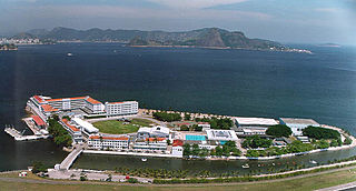
WThe Brazilian Naval School is the service academy of the Brazilian Navy, located in Rio de Janeiro, on Villegagnon Island just inside of Guanabara Bay.
WFlamengo is a neighborhood in Rio de Janeiro, Brazil.
 W
WFort Coligny was a fortress founded by Nicolas Durand de Villegaignon in Rio de Janeiro, Brazil in 1555, in what constituted the so-called France Antarctique historical episode.
 W
WGovernador Island is the largest island in Guanabara Bay, in Rio de Janeiro, Brazil. It has a population of about 211,018 inhabitants, in a small area of 42 km2 (16 sq mi).
WGreater Rio de Janeiro, officially the Rio de Janeiro Metropolitan Region is a large metropolitan area located in Rio de Janeiro state in Brazil, the second largest in Brazil and third largest in South America. It consists of 22 municipalities, including the state capital, Rio de Janeiro.
 W
WGuapimirim, is a city in the Rio de Janeiro Metropolitan Area, and a municipality located in Rio de Janeiro state, Southeast Region, Brazil.
WGuapimirim Environmental Protection Area is a coastal marine protected area on Guanabara Bay in the state of Rio de Janeiro, southeastern Brazil.
 W
WIlha das Cobras is an island located within Guanabara Bay in the city and state of Rio de Janeiro, Brazil. It is east of the neighborhood Guanabara. It is home to the Arsenal de Marinha do Rio de Janeiro base of the Brazilian Navy.
 W
WIlha Fiscal is an island in Guanabara Bay, bordering the historic city center of Rio de Janeiro, in southeastern Brazil.
 W
WJardim Gramacho is a neighborhood in the city of Duque de Caxias and the state of Rio de Janeiro.
 W
WMagé is a municipality located in the Brazilian state of Rio de Janeiro.
 W
WMarina da Glória is a marina located in the neighbourhood of Glória in Rio de Janeiro, Brazil. This venue hosted the sailing events for the 2016 Summer Olympics within the Flamengo Park cluster, from 7 to 19 August 2016. and the 2016 Summer Paralympics. It also hosted the draw procedure for the Qualification for the 2014 FIFA World Cup.
 W
WThe Meriti is a river in Rio de Janeiro state in south-eastern Brazil.
 W
WNiterói is a municipality of the state of Rio de Janeiro in the southeast region of Brazil. It lies across Guanabara Bay facing the city of Rio de Janeiro and forms part of the Rio de Janeiro Metropolitan Area. It was the state capital, as marked by its golden mural crown, from 1834 to 1894 and again from 1903 to 1975. It has an estimated population of 511,786 inhabitants (2018) and an area of 129.375 km2 (49.952 sq mi), making it the fifth most populous city in the state. It has the highest Human Development Index of the state and the seventh largest among Brazil's municipalities in 2010. Individually, it is the second municipality with the highest average monthly household income per capita in Brazil and appears in 13th place among the municipalities of the country according to social indicators related to education. The city has the nicknames of Nikity, Nicki City and the Smile City (Cidade Sorriso).
 W
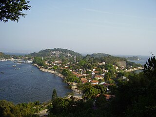
WPaquetá Island is an island in Guanabara Bay, Rio de Janeiro. The name of the island is a Tupi word meaning "many pacas". The island is an auto-free zone, so travel is limited to bicycles and horse-drawn carriages. Paquetá has twenty baobabs, the only ones in Brazil beside the Baobá in Passeio Público. One of the trees is called "Maria Gorda", which residents kiss for luck.
 W
WThe Pista Cláudio Coutinho is a walking/running trail located beneath Sugarloaf Mountain in the Rio de Janeiro neighborhood of Urca. The paved trail is 1.25 km long, has many native Brazilian trees with lot´s of birds and small monkeys. Halfway down the trail is the entrance to the unpaved trail that leads to the top of the first of Sugarloaf Mountain's two humps. The area is frequented by families, tourists and local runners.
 W
WPonte do Saber is a cable-stayed bridge in Rio de Janeiro, Brazil.
 W
WRio de Janeiro, or simply Rio, is anchor to the Rio de Janeiro metropolitan area and the second-most populous municipality in Brazil and the sixth-most populous in the Americas. Rio de Janeiro is the capital of the state of Rio de Janeiro, Brazil's third-most populous state, after São Paulo and Minas Gerais. Part of the city has been designated as a World Heritage Site, named "Rio de Janeiro: Carioca Landscapes between the Mountain and the Sea", by UNESCO on 1 July 2012 as a Cultural Landscape.
 W
WPresident Costa e Silva Bridge, commonly known as the Rio–Niterói Bridge, is a box girder bridge crossing Guanabara Bay, in the State of Rio de Janeiro in Brazil. It connects the cities of Rio de Janeiro and Niterói. It is currently the longest prestressed concrete bridge in the southern hemisphere, and the sixth-longest in the world. From its completion in 1974 until 1985 it was the world's second-longest bridge, second only to the Lake Pontchartrain Causeway.
 W
WRio de Janeiro-Santos Dumont Airport is the second major airport serving Rio de Janeiro, Brazil. It is named after the Brazilian aviation pioneer Alberto Santos Dumont (1873–1932). It is operated by Infraero.
 W
WSão Gonçalo is a municipality located in the Brazilian state of Rio de Janeiro. It is on northeastern Guanabara Bay in the Rio de Janeiro Metropolitan Area.
 W
WSugarloaf Mountain is a peak situated in Rio de Janeiro, Brazil, at the mouth of Guanabara Bay on a peninsula that juts out into the Atlantic Ocean. Rising 396 m (1,299 ft) above the harbor, its name is said to refer to its resemblance to the traditional shape of concentrated refined loaf sugar. It is known worldwide for its cableway and panoramic views of the city and beyond.
 W
WUrca is a traditional and wealthy residential neighborhood with nearly 7,000 inhabitants in Rio de Janeiro, Brazil. Although most of the neighborhood dates from the 1920s, parts of it are much older. What is now called the Forte São João, a military base at the foot of the Sugarloaf Mountain, is where the first Portuguese settlement in Rio was founded by Estácio de Sá on March 1, 1565. The French had arrived 12 years earlier and founded a settlement, called France Antarctique, close to what is now Flamengo and Gloria districts, in downtown Rio. The French, riven by internal disputes between Catholics and Protestants, were massacred by the Portuguese and their Indian allies in attacks organised from here, expelling them from the nearby Villegagnon Island. The street now called Rua São Sebastião, in Urca, which leads from behind the fort to the Urca casino, was originally a trail from the Portuguese fort skirting the edge of the sea to the mainland along the peninsula that houses the Sugar Loaf and a smaller hill, the Morro da Urca. Rua São Sebastião thus has some claim to be the oldest street in Rio.
WVillegagnon Island is located near the mouth of the large Guanabara Bay, in the city of Rio de Janeiro, Brazil.