 W
WAn alley or alleyway is a narrow lane, path, or passageway, often reserved for pedestrians, which usually runs between, behind, or within buildings in the older parts of towns and cities. It is also a rear access or service road, or a path, walk, or avenue in a park or garden.
 W
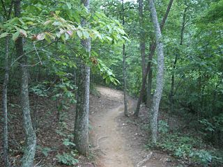
WA trail is usually a path, track or unpaved lane or road. In the United Kingdom and the Republic of Ireland, path or footpath is the preferred term for a walking trail. The term is also applied, in North America, to routes along rivers, and sometimes to highways. In the US, the term was historically used for a route into or through wild territory used by emigrants. In the USA "trace" is a synonym for trail, as in Natchez Trace. Some trails are single use and can only be used for walking, cycling, horse riding, snowshoeing, and cross-country skiing; others, as in the case of a bridleway in the UK, are multi-use, and can be used by walkers, cyclists and equestrians. There are also unpaved trails used by dirt bikes and other off-road vehicles and in some places, like the Alps, trails are used for moving cattle and other livestock.
 W
WA bike path is a bikeway separated from motorized traffic and dedicated to cycling or shared with pedestrians or other non-motorized users. In the US a bike path sometimes encompasses shared use paths, "multi-use path", or "Class III bikeway" is a paved path that has been designated for use by cyclists outside the right of way of a public road. It may or may not have a center divider or stripe to prevent head-on collisions. In the UK, a shared-use footway or multi-use path is for use by both cyclists and pedestrians.
 W
WA bridle path, also bridleway, equestrian trail, horse riding path, ride, bridle road, or horse trail, is a path, trail or a thoroughfare that is used by people riding on horses. Trails originally created for use by horses often now serve a wider range of users, including equestrians, hikers, and cyclists. Such paths are either impassable for motorized vehicles, or vehicles are banned. The laws relating to allowable uses vary from country to country.
 W
WA byway in the United Kingdom is a track, often rural, which is too minor to be called a road. These routes are often unsurfaced, typically having the appearance of 'green lanes'. Despite this, it is legal to drive any type of vehicle along certain byways, the same as any ordinary tarmac road.
 W
WThe Czech Hiking Markers Standard is an international system of hiking markers for tourist trails, used in more countries than any competing standard. The signs and markers can be used in both wilderness and cities.
 W
WCzech Tourist Club, known also as Czech Hiking Club was created in 1888. With over 40.000 members, it is a large organisation responsible for maintaining the dense Czech Hiking Markers System.
 W
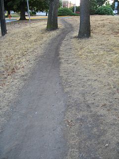
WA desire path is a path created as a consequence of erosion caused by human or animal foot traffic. The path usually represents the shortest or most easily navigated route between an origin and destination. The width and severity of erosion are often indicators of the traffic level that a path receives. Desire paths emerge as shortcuts where constructed paths take a circuitous route, have gaps, or are non-existent.
 W
WIn mountain biking and skiing, a fall line refers to the line down a mountain or hill which is most directly downhill; that is, the direction a ball or other body would accelerate if it were free to move on the slope under gravity. In mountain biking, a trail follows the "fall line" if it generally descends in the most downward direction, rather than traversing in a sideways direction. A skier is said to be "skiing the fall line" if he or she is moving generally down, making turns either side of the fall line, rather than moving across the slope. Mathematically the fall line, the line of greatest slope, is the negative of the gradient and perpendicular to the contour lines.
 W
WA footpath is a type of thoroughfare that is intended for use only by pedestrians and not other forms of traffic such as motorized vehicles, cycles, and horses. They can be found in a wide variety of places, from the centre of cities, to farmland, to mountain ridges. Urban footpaths are usually paved, may have steps, and can be called alleys, lanes, steps, etc.
 W
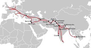
WThe hippie trail is the name given to the overland journey taken by members of the hippie subculture and others from the mid-1950s to the late 1970s between Europe and South Asia, mainly through Iran, Afghanistan, Pakistan, India, and Nepal. The hippie trail was a form of alternative tourism, and one of the key elements was travelling as cheaply as possible, mainly to extend the length of time away from home. The term "hippie" became current in the mid-to-late 1960s; "beatnik" was the previous term from the later 1950s.
 W
WHistoric roads are paths or routes that "have great historical importance or fame". Examples exist from prehistoric times until the early 20th century. They include ancient trackways, tracks, and roads that existed in "the period of history before the fall of the Western Roman Empire" in 476 AD. "The first roads were paths made by animals and later adapted by humans." Many historic routes, such as the Silk Road, the Amber Road, and the Royal Road of the Persian Empire, existed before the Christian era and covered great distances.
Liberation Route Europe is an international remembrance trail that connects the main regions along the advance of the Western Allied Forces toward the liberation of Europe and final stage of the Second World War. The route started in 2008 as a Dutch regional initiative in the Arnhem-Nijmegen area and then developed into a transnational route that was officially inaugurated in Arromanches on June 6, 2014, during the Normandy D-day commemorations. The route goes from Southern England,, through France, Belgium, Luxembourg, the Netherlands to Berlin, in Germany and then extends to the Czech Republic and Poland. The southern route starts in Italy. As a form of remembrance tourism LRE aims to unfold these Allied offensives of 1944 and 1945 in one narrative combining the different perspectives and points of view. By combining locations with personal stories of people who fought and suffered there, it gives visitors the opportunity to follow the Allied march and visit significant sites from war cemeteries to museums and monuments but also events and commemorations. In April 2019, Liberation Route Europe became a certified Cultural Route of the Council of Europe.
 W
WA long-distance trail is a longer recreational trail mainly through rural areas used for hiking, backpacking, cycling, horse riding or cross-country skiing. They exist on all continents except Antarctica.
 W
WThe Manayunk Canal Towpath is a trail that runs along the Schuylkill River Canal in Manayunk, Pennsylvania, a northwest section of Philadelphia. The Towpath parallels the Manayunk Canal and the Schuylkill River. The Towpath is accessible from Fairmount Park to the East and from the Schuylkill River Trail to the West. As the Towpath runs through heavy industry and rural-like settings, its surface varies between boardwalk, gravel, and pavement. This makes the Towpath ideal for running, walking, and cycling. Fishing in the Schuylkill Canal along the Manayunk Towpath is a favorite past time for visitors and residents alike. Visible along the Towpath are rail lines, old canal locks, ruins of the lock tender's house and old textile mills. Plentiful wildlife thrives along the Manayunk Canal Towpath including many species of birds, fish, turtles, and native plants. The Manayunk Development Corporation is currently organizing a full restoration of the Manayunk Canal; once the restoration is complete, it will be possible for canoes and small boats to sail through the Manayunk Canal Towpath as they make their way down the Schuylkill River.
 W
WThe National Trails System was created by the National Trails System Act, codified at 16 U.S.C. § 1241 et seq.
 W
WPenedo Furado is a waterfall and lake located in the parish of Vila de Rei, in Vila de Rei Municipality in the Castelo Branco, Portugal.
 W
WThe Saucon Rail Trail is a converted railroad track that runs through Upper Saucon Township and Lower Saucon Township in Pennsylvania. The trail is 7.5 miles long and is mostly flat with few hills. It is open during all seasons. The surface of the trial is covered in gravel and crushed rock with some parts covered in pavement. The trail is popular for walking, running, and biking. The trail is also wheelchair accessible. The Saucon Rail Trail is used for organized events like 5Ks, 10Ks, and races throughout the course of the year. Dogs are allowed on the trail as long as they remain on leash.
 W
WA scenic viewpoint – also called an observation point, viewpoint, viewing point, vista point, lookout, scenic overlook, etc. – is an elevated location where people can view scenery and photograph it. Scenic viewpoints may be created alongside mountain roads, often as simple turnouts or lay-bys where motorists can pull over onto pavement, gravel, or grass on the right-of-way.
 W
WSingletrack describes a type of mountain biking trail that is approximately the width of the bike. It contrasts with double-track or fire road which is wide enough for four-wheeled off-road vehicles. It is often smooth and flowing, but may also feature technical rocky sections, go over tree roots, and include berms, banked turns, switch-backs, hills, drops, jumps, and so forth. Singletrack which descends significantly, and in the most downward direction, is said to be following the fall line.
 W
WThe Sufi Trail is an 801-kilometre (498 mi) long-distance footpath in Western Turkey from Istanbul to Konya following the Ottoman Sultans Hajj route. The Sufi Trail connects to the Sultans Trail, a long-distance footpath from Vienna to Istanbul.
 W
WTrail blazing or way marking is the practice of marking paths in outdoor recreational areas with signs or markings that follow each other at certain, though not necessarily exactly defined, distances and mark the direction of the trail.
 W
WTrail ethics deals with ethics as it applies to the use of trails. It is similar to both environmental ethics and human rights in that it deals with the shared interaction of humans and nature. There are multiple agencies and groups that support and encourage ethical behavior on trails.
 W
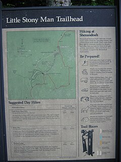
WA trailhead is the point at which a trail begins, where the trail is often intended for hiking, biking, horseback riding, or off-road vehicles. Modern trailheads often contain rest rooms, maps, sign posts and distribution centers for informational brochures about the trail and its features, and parking areas for vehicles and trailers. The United States access board states "A trailhead is defined as an outdoor space that is designated by an entity responsible for administering or maintaining a trail to serve as an access point to the trail."
 W
WIn late December 1980, there was a series of reported sightings of unexplained lights near Rendlesham Forest, Suffolk, England which have become linked with claims of UFO landings. The events occurred just outside RAF Woodbridge, which was used at the time by the United States Air Force (USAF). USAF personnel, including deputy base commander Lieutenant Colonel Charles I. Halt, claimed to see things they described as a UFO sighting.
 W
WWayfinding encompasses all of the ways in which people orient themselves in physical space and navigate from place to place.