 W
WTides are the rise and fall of sea levels caused by the combined effects of the gravitational forces exerted by the Moon and the Sun, and the rotation of the Earth.
 W
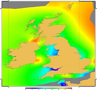
WAn amphidromic point, also called a tidal node, is a geographical location which has zero tidal amplitude for one harmonic constituent of the tide. The tidal range for that harmonic constituent increases with distance from this point.
 W
WAmsterdam Ordnance Datum or Normaal Amsterdams Peil (NAP) is a vertical datum in use in large parts of Western Europe. Originally created for use in the Netherlands, its height was used by Prussia in 1879 for defining Normalnull, and in 1955 by other European countries. In the 1990s, it was used as the reference level for the United European leveling Network (UELN) which in turn led to the European Vertical Reference System (EVRS).
 W
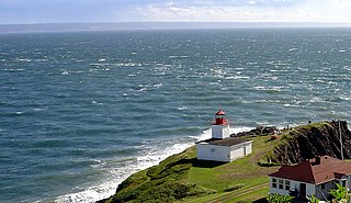
WThe Dory Rips is a phenomenon involving extreme tidal agitation of waters located in the Bay of Fundy off the headland of Cape d'Or in Nova Scotia, Canada.
 W
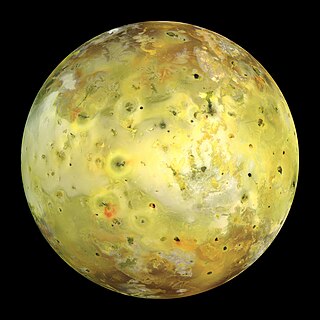
WA galactic tide is a tidal force experienced by objects subject to the gravitational field of a galaxy such as the Milky Way. Particular areas of interest concerning galactic tides include galactic collisions, the disruption of dwarf or satellite galaxies, and the Milky Way's tidal effect on the Oort cloud of the Solar System.
 W
WHead of tide, tidal limit or tidehead is the farthest point upstream where a river is affected by tidal fluctuations, or where the fluctuations are less than a certain amount. This applies to rivers which flow into tidal bodies such as oceans, bays and deltas.
 W
WThe Hill sphere or Roche sphere of an astronomical body is the region in which it dominates the attraction of satellites. The outer shell of that region constitutes a zero-velocity surface. To be retained by a planet, a moon must have an orbit that lies within the planet's Hill sphere. That moon would, in turn, have a Hill sphere of its own. Any object within that distance would tend to become a satellite of the moon, rather than of the planet itself. One simple view of the extent of the Solar System is the Hill sphere of the Sun with respect to local stars and the galactic nucleus.
 W
WThe Horizontal Falls, or Horizontal Waterfalls, nicknamed the "Horries" and known as Garaanngaddim to the local Indigenous people, are an unsusual natural phenomenon on the coast of the Kimberley region in Western Australia, where tidal flows cause waterfalls on the ebb and flow of each tide.
 W
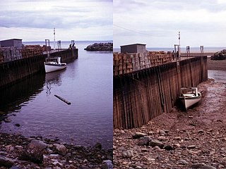
WThe intertidal zone, also known as the foreshore or seashore, is the area above water level at low tide and underwater at high tide. This area can include several types of habitats with various species of life, such as seastars, sea urchins, and many species of coral. Sometimes it is referred to as the littoral zone, although that can be defined as a wider region.
 W
WA tidal island is a piece of land that is connected to the mainland by a natural or man-made causeway that is exposed at low tide and submerged at high tide. Because of the mystique surrounding tidal islands, many of them have been sites of religious worship, such as Mont-Saint-Michel with its Benedictine Abbey. Tidal islands are also commonly the sites of fortresses because of their natural fortifications.
 W
WA king tide is an especially high spring tide, especially the perigean spring tides which occur three or four times a year.
 W
WLong-period tides are gravitational tides with periods longer than one day, typically with amplitudes of a few centimeters or less. Long-period tidal constituents with relatively strong forcing include the lunar fortnightly (Mf) and lunar monthly (Ms) as well as the solar semiannual (Ssa) and solar annual (Sa) constituents.
 W
WThe theory of tides is the application of continuum mechanics to interpret and predict the tidal deformations of planetary and satellite bodies and their atmospheres and oceans under the gravitational loading of another astronomical body or bodies.
 W
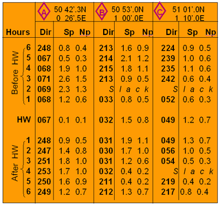
WTidal diamonds are symbols on British admiralty charts that indicate the direction and speed of tidal streams.
 W
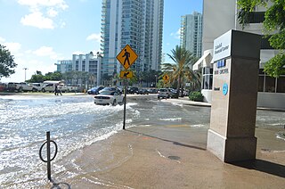
WTidal flooding, also known as sunny day flooding or nuisance flooding, is the temporary inundation of low-lying areas, especially streets, during exceptionally high tide events, such as at full and new moons. The highest tides of the year may be known as the king tide, with the month varying by location.
 W
WTidal heating occurs through the tidal friction processes: orbital and rotational energy is dissipated as heat in either the surface ocean or interior of a planet or satellite. When an object is in an elliptical orbit, the tidal forces acting on it are stronger near periapsis than near apoapsis. Thus the deformation of the body due to tidal forces varies over the course of its orbit, generating internal friction which heats its interior. This energy gained by the object comes from its gravitational energy, so over time in a two-body system, the initial elliptical orbit decays into a circular orbit. Sustained tidal heating occurs when the elliptical orbit is prevented from circularizing due to additional gravitational forces from other bodies that keep tugging the object back into an elliptical orbit. In this more complex system, gravitational energy still is being converted to thermal energy; however, now the orbit's semimajor axis would shrink rather than its eccentricity.
 W
WTidal power or tidal energy is harnessed by converting energy from tides into useful forms of power, mainly electricity using various methods.
 W
WTidal race or tidal rapid is a natural occurrence whereby a fast-moving tide passes through a constriction, resulting in the formation of waves, eddies and hazardous currents. The constriction can be a passage where the sides narrow, for example the Gulf of Corryvreckan and the Saltstraumen maelstrom, or an underwater obstruction, such as is found at the Portland Race in the United Kingdom.
 W
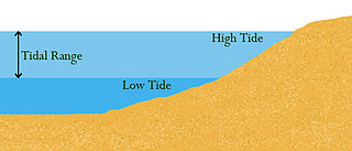
WTidal range the height difference between high tide and low tide. Tides are the rise and fall of sea levels caused by gravitational forces exerted by the Moon and Sun and the rotation of Earth. Tidal range is not constant but changes depending on the locations of the Moon and Sun.
 W
WIn oceanography, a tidal resonance occurs when the tide excites one of the resonant modes of the ocean. The effect is most striking when a continental shelf is about a quarter wavelength wide. Then an incident tidal wave can be reinforced by reflections between the coast and the shelf edge, the result producing a much higher tidal range at the coast.
 W
WTidal triggering of earthquakes is the idea that tidal forces may induce seismicity.
 W
WTide pools or rock pools are shallow pools of seawater that form on the rocky intertidal shore. Many of these pools exist as separate bodies of water only at low tide.
 W
WTide-Predicting Machine No. 2, also known as Old Brass Brains, was a special-purpose mechanical computer that uses gears, pulleys, chains, and other mechanical components to compute the height and time of high and low tides for specific locations. The machine can perform tide calculations much faster than a person could do with pencil and paper. The U.S. Coast and Geodetic Survey put the machine into operation in 1910. It was used until 1965, when it was replaced by an electronic computer.
 W
WVanishing island refers to any permanent island which is exposed at low tide but is submersed at high tide. Vanishing islands occur globally. There are vanishing islands in the Philippines and several in the San Juan Islands.
 W
WVertical Offshore Reference Frames (VORF) is a set of high resolution surfaces which together define the vertical datum for hydrographic surveying and charting in the United Kingdom and Ireland. The following surfaces are included:Chart Datum (CD) Lowest Astronomical Tide (LAT) Mean Sea Level (MSL) Mean Low Water Springs (MLWS) Mean High Water Springs (MHWS) Highest Astronomical Tide (HAT) Land datums including Ordnance Datums Newlyn, Belfast and Poolbeg