 W
WThe era of steamboats on the Arrow Lakes and adjoining reaches of the Columbia River is long-gone but was an important part of the history of the West Kootenay and Columbia Country regions of British Columbia. The Arrow Lakes are formed by the Columbia River in southeastern British Columbia. Steamboats were employed on both sides of the border in the upper reaches of the Columbia, linking port-towns on either side of the border, and sometimes boats would be built in one country and operated in the other. Tributaries of the Columbia include the Kootenay River which rises in Canada, then flows south into the United States, then bends north again back into Canada, where it widens into Kootenay Lake. As with the Arrow Lakes, steamboats once operated on the Kootenay River and Kootenay Lake.
 W
WSteam navigation on Lake Coeur d'Alene lasted from the 1880s to the 1930s. More steamboats operated on Lake Coeur d’Alene than on any other lake west of the Great Lakes. The high point of steam navigation was probably from 1908 to 1913. After that railroads, and increasingly automobile and truck traffic on newly built highways supplanted steam navigation, although some vessels continued to be operated until the mid-1930s.
 W
WSteamboats on the Colorado River operated from the river mouth at the Colorado River Delta on the Gulf of California in Mexico, up to the Virgin River on the Lower Colorado River Valley in the Southwestern United States from 1852 until 1909, when the construction of the Laguna Dam was completed. The shallow draft paddle steamers were found to be the most economical way to ship goods between the Pacific Ocean ports and settlements and mines along the lower river, putting in at landings in Sonora state, Baja California Territory, California state, Arizona Territory, New Mexico Territory, and Nevada state. They remained the primary means of transportation of freight until the advent of the more economical railroads began cutting away at their business from 1878 when the first line entered Arizona Territory.
 W
WFrom 1886 to 1920, steamboats ran on the upper reaches of the Columbia and Kootenay in the Rocky Mountain Trench, in western North America. The circumstances of the rivers in the area, and the construction of transcontinental railways across the trench from east to west made steamboat navigation possible.
 W
WMany steamboats operated on the Columbia River and its tributaries, in the Pacific Northwest region of North America, from about 1850 to 1981. Major tributaries of the Columbia that formed steamboat routes included the Willamette and Snake rivers. Navigation was impractical between the Snake River and the Canada–US border, due to several rapids, but steamboats also operated along the Wenatchee Reach of the Columbia, in northern Washington, and on the Arrow Lakes of southern British Columbia.
 W
WThe Congo River is divided into three navigable parts, by seagoing ship to Matadi, where there is a wharf and port, a rail bypassing the mighty falls for 200 miles; and then a middle section of over 1000 miles from Leopoldville (Kinshasa) to Stanleyville (Kisangani) where the Stanley Falls breaks the river. The upper section of the river is partially navigable to Lubumbashi, a measure of 1000 miles. The large copper deposits of Katanga are conveyed from Elisabethville (Lumbumbashi). The Congo River was an open river in that it was free for all nations to use as per an 1885 international agreement, which was tested by an Oscar Chinn, a British national, in the International Court in 1931.
 W
WThe Coos Bay Mosquito Fleet comprised numerous small steamboats and motor vessels which operated in the late 19th and early 20th centuries on Coos Bay, a large and mostly shallow harbor on the southwest coast of the U.S. state of Oregon, to the north of the Coquille River valley. Coos Bay is the major harbor on the west coast of the United States between San Francisco and the mouth of the Columbia River.
 W
WThe Cowlitz River flows into the Columbia River at a point 68 miles from the Columbia's mouth, in southwestern Washington, United States.
 W
WFerries and steamboats of Lake Crescent, Washington were used for water transport of passengers and freight before highways were built in the area in the early 1920s. Prior to highway construction, Lake Crescent was used as a route from Port Townsend into the northwestern part of the Olympic Peninsula. Ferries, steamboats and similar water craft were built and used on the lake until the Olympic Highway was completed along the south shore of the lake in 1922.
 W
WTwelve paddlewheel steamboats plied the upper Fraser River in British Columbia from 1863 until 1921. They were used for a variety of purposes: working on railroad construction, delivering mail, promoting real estate in infant townsites and bringing settlers in to a new frontier. They served the towns of Quesnel, Barkerville and Fort George. Some only worked the Fraser from Soda Creek to Quesnel, while others went all the way to Tête Jaune Cache or took the Nechako River and served Fort Fraser and beyond.
 W
WThis article is about Steamboats of the Lower Fraser River and Harrison Lake. The first steamboat on the Fraser River was the SS Beaver which entered Pacific waters in 1835. It was an itinerant supply for the Hudson's Bay Company roving throughout the lower Columbia River in Oregon and around coastal Washington, British Columbia and southeastern Russian America (Alaska), long before those political entities came into being.
 W
WThe history of commercial passenger shipping on the Great Lakes is long but uneven. It reached its zenith between the mid-19th century and the 1950s. As early as 1844, palace steamers carried passengers and cargo around the Great Lakes. By 1900, fleets of relatively luxurious passenger steamers plied the waters of the lower lakes, especially the major industrial centres of Chicago, Milwaukee, Detroit, Cleveland, Buffalo, and Toronto.
 W
WThe Lakes Route is an alternate name for the Douglas Road, which was the first formally designated "road" into the Interior of British Columbia, Canada from its Lower Mainland area flanking the Lower Fraser River. Also known as the Douglas-Lillooet Trail or the Lillooet Trail, the route consisted of a series of wagon roads connected via lake travel in between. A variety of craft were used on the lakes, from steamboats to sail-driven rafts to, through the early 20th Century, diesel and other engines. Lake travel continued for commerce, passenger travel and heavy freight until after World War II.
 W
WThe Mackenzie River in Canada's Northwest Territories is a historic waterway, used for centuries by Indigenous Canadian peoples as a travel and hunting corridor. It is part of a larger watershed that includes the Slave, Athabasca, and Peace rivers extending from northern Alberta. In the 1780s, Peter Pond, a trader with the North West Company became the first known European to visit this watershed and begin viable trade with the Athapascan-speaking Dene of these rivers. The Mackenzie River itself, the great waterway extending to the Arctic Ocean, was first put on European maps by Alexander Mackenzie in 1789, the Scottish trader who explored the river. The watershed thus became a vital part of the North American fur trade, and before the advent of the airplane or road networks, the river was the only communication link between northern trading posts and the south. Water travel increased in the late 19th century as traders, dominated primarily by the Hudson's Bay Company (HBC), looked to increase water services in the Mackenzie River District.
 W
WSteamboats played a major role in the 19th-century development of the Mississippi River and its tributaries by allowing the practical large-scale transport of passengers and freight both up- and down-river. Using steam power, riverboats were developed during that time which could navigate in shallow waters as well as upriver against strong currents. After the development of railroads, passenger traffic gradually switched to this faster form of transportation, but steamboats continued to serve Mississippi River commerce into the early 20th century. A small number of steamboats are used for tourist excursions into the 21st century.
 W
WOkanagan Lake is a large, deep lake in the Okanagan Valley of British Columbia, Canada. The lake is 135 km (84 mi) long, between 4 and 5 km wide, and has a surface area of 348 km2.
 W
WThe history of steamboats on the Oregon Coast begins in the late 19th century. Before the development of modern road and rail networks, transportation on the coast of Oregon was largely water-borne. This article focuses on inland steamboats and similar craft operating in, from south to north on the coast: Rogue River, Coquille River, Coos Bay, Umpqua River, Siuslaw Bay, Yaquina Bay, Siletz River, and Tillamook Bay. The boats were all very small, nothing like the big sternwheelers and propeller boats that ran on the Columbia River or Puget Sound. There were many of them, however, and they came to be known as the "mosquito fleet."
 W
WThe Peace River, which flows from the Rocky Mountains in British Columbia to the Peace–Athabasca Delta and Lake Athabasca in Alberta, was navigable by late nineteenth and early twentieth century steamboats from the Rocky Mountain Falls at Hudson's Hope to Fort Vermilion, where there was another set of rapids, then via the lower Peace from Vermilion to Lake Athabasca. The Peace is part of the Mackenzie Basin, a larger river complex which includes the Athabasca, Slave, and Mackenzie Rivers.
 W
WThe Puget Sound mosquito fleet was a multitude of private transportation companies running smaller passenger and freight boats on Puget Sound and nearby waterways and rivers. This large group of steamers and sternwheelers plied the waters of Puget Sound, stopping at every waterfront dock. The historical period defining the beginning and end of the mosquito fleet is ambiguous, but the peak of activity occurred between the First and Second World Wars.
 W
WThe Skeena River is British Columbia’s fastest flowing waterway, often rising as much as 17 feet (5.2 m) in a day and fluctuating as much as sixty feet between high and low water. For the steamboat captains, that wide range made it one of the toughest navigable rivers in British Columbia. Nevertheless, at least sixteen paddlewheel steamboats plied the Skeena River from the coast to Hazelton from 1864 to 1912.
 W
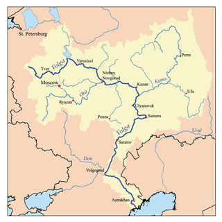
WThe Volga River is Europe's longest river, and a major trade artery in that continent. The technological arrival of the steam engine allowed cargoes to be more easily moved upstream. The use of steamboats on the Volga River began in the year 1821.
 W
WLake Washington steamboats and ferries operated from about 1875 to 1951, transporting passengers, vehicles and freight across Lake Washington, a large lake to the east of Seattle, Washington. Before modern highways and bridges were built, the only means of crossing the lake, other than the traditional canoe or rowboat, was by steamboat, and, later, by ferry. While there was no easily navigable connection to Puget Sound, the Lake Washington Ship Canal now connects Lake Washington to Lake Union, and from there Puget Sound is reached by way of the Hiram M. Chittenden Locks.
 W
WThe Willamette River flows northwards down the Willamette Valley until it meets the Columbia River at a point 101 miles from the Pacific Ocean, in the U.S. state of Oregon.
 W
WYaquina Bay, like Coos Bay, is a shallow coastal bay on the Oregon Coast in the Pacific Northwest of North America. The principal town on Yaquina Bay is Newport, Oregon. The Yaquina River flows into the bay. Until modern roads reached Newport in the late 1920s, the principal transportation method to and from Newport was by ship or boat.
 W
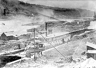
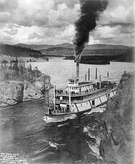
WSteamboats on the Yukon River played a role in the development of Alaska and Yukon. Access to the interior of Alaska and Yukon was hindered by large mountains and distance, but the wide Yukon River provided a feasible route. The first steamers on the lower Yukon River were work boats for the Collins Overland Telegraph in 1866 or 1867, with a small steamer called Wilder. The mouth of the Yukon River is far to the west at St. Michael and a journey from Seattle or San Francisco covered some 4,000 miles (6,400 km).