 W
WThe San Joaquin River is the longest river of Central California in the United States. The 366-mile (589 km) long river starts in the high Sierra Nevada, and flows through the rich agricultural region of the northern San Joaquin Valley before reaching Suisun Bay, San Francisco Bay, and the Pacific Ocean. An important source of irrigation water as well as a wildlife corridor, the San Joaquin is among the most heavily dammed and diverted of California's rivers.
 W
WStockton Deepwater Shipping Channel also called the Baldwin-Stockton Deepwater Shipping Channel or Stockton Deep Water Channel is a manmade deepwater water channel that runs from Suisun Bay and the Sacramento River - Sacramento Deep Water Ship Channel to the Port of Stockton and the Stockton Channel in California. The Stockton Ship Channel is 41 mi (66 km) long and about 37 ft (11 m) deep, allowing up to Panama Canal size ocean ships access to the Port of Stockton at the City of Stockton. The Stockton Deepwater Shipping Channel is part of the vast Sacramento–San Joaquin River Delta that has a connection to the Pacific Ocean. Stockton Deepwater Shipping Channel is also called the lower San Joaquin River.
 W
WThe Sacramento–San Joaquin River Delta, or California Delta, is an expansive inland river delta and estuary in Northern California. The Delta is formed at the western edge of the Central Valley by the confluence of the Sacramento and San Joaquin rivers and lies just east of where the rivers enter Suisun Bay. The Delta is recognized for protection by the California Bays and Estuaries Policy. Sacramento–San Joaquin Delta was designated a National Heritage Area on March 12, 2019. The city of Stockton is located on the San Joaquin River on the eastern edge of the delta. The total area of the Delta, including both land and water, is about 1,100 square miles (2,800 km2). Its population is around 500,000 residents.
 W
WAndrus Island is an island in the Sacramento-San Joaquin River Delta in Sacramento County, California, twenty kilometres northeast of Antioch. The 3,000-hectare (7,400-acre) island is bounded on the north, and northwest by the Sacramento River, on the west, Georgiana Slough, on the southeast, Mokelumne River, and San Joaquin River, on the southwest Jackson Slough, and Seven Mile Slough. The island is entirely within the bounds of the immense Rio Vista Gas Field, although well drilling pads and associated infrastructure make up only a small part of its land use, which is mainly agriculture.
 W
WThe Big Creek Hydroelectric Project is an extensive hydroelectric power scheme on the upper San Joaquin River system, in the Sierra Nevada of central California. The project is owned and operated by Southern California Edison (SCE). The use and reuse of the waters of the San Joaquin River, its South Fork, and the namesake of the project, Big Creek – over a vertical drop of 6,200 ft (1,900 m) – have over the years inspired a nickname, "The Hardest Working Water in the World".
 W
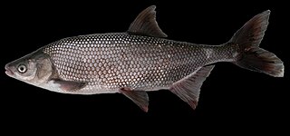
WThe California roach is a cyprinid fish native to western North America and abundant in the intermittent streams throughout central California. Once considered the sole member of its genus, it has recently been split into a number of closely related species and subspecies.
 W
WH. V. Eastman Lake is an artificial lake formed by the construction of Buchanan Dam across the Chowchilla River in the foothills of Madera County, California. A small percentage of the northwest area of the reservoir is in Mariposa County.
 W
WThe Friant-Kern Canal is a 152 mi (245 km) aqueduct managed by the United States Bureau of Reclamation in Central California to convey water to augment irrigation capacity in Fresno, Tulare, and Kern counties. A part of the Central Valley Project, canal construction began in 1949 and was completed in 1951 at a cost of $60.8 million.
 W
WThe hitch is a cyprinid fish endemic to central California, and was once very common. The name is derived from the Pomoan word for this species.
 W
WMammoth Pool Reservoir is a reservoir on the San Joaquin River in the Sierra Nevada, within the Sierra National Forest in California. It creates the border between Fresno County and Madera County. It is about 45 miles (72 km) north-northeast of Fresno.
WLake Martha is a lake in Kings Canyon National Park, on the Le Conte Divide, 1.0 mile (1.6 km) north of Mount Reinstein and 1.2 miles (1.9 km) southwest of Mount Goddard. Lake Martha is notable for being the source of the south fork of the San Joaquin River. It is also on the easiest route to Hell for Sure Pass. Due to its elevation, it can be completely frozen at high summer (August).
 W
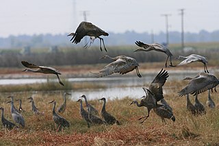
WThe Merced National Wildlife Refuge encompasses 10,262 acres (41.53 km2) of wetlands, native grasslands, vernal pools, and riparian areas in California. It was established in 1951 under the Lea Act to attract wintering waterfowl from adjacent farmland where their foraging was causing crop damage. In the last few decades, changes in agricultural practices and refuge management have reduced these wildlife/crop issues.
 W
WMillerton Lake is an artificial lake near the town of Friant about 15 mi (24 km) north of downtown Fresno. The reservoir was created by the construction of 319 ft high Friant Dam on the San Joaquin River which, with the lake, serves as much of the county line between Fresno County to the south and Madera County to the north.
 W
WPardee Dam is a 345-foot (105 m)-high structure across the Mokelumne River which marks the boundary between Amador and Calaveras Counties, located in the foothills of the Sierra Nevada approximately 30 miles (48 km) northeast of Stockton.
WThe Port of Stockton is a major deepwater port on the Stockton Ship Channel of the Pacific Ocean and an inland port located more than seventy nautical miles from the ocean, in Stockton, California on the Stockton Channel and San Joaquin River-Stockton Deepwater Shipping Channel. The port sits on about 4,200 acres (17 km2), and occupies an island in the Sacramento–San Joaquin River Delta, and a portion of a neighborhood known as Boggs Tract. It is governed by a commission appointed by the City of Stockton and San Joaquin County. In 2012 it employed 4,500 people and made about $4.9 million in local tax funds.
 W
WThe Sacramento blackfish is a species of freshwater fish in central California. A cyprinid, the blackfish is the sole member of its genus.
 W
WThe Sacramento perch is an endangered sunfish native to the Sacramento–San Joaquin River Delta, Pajaro, and Salinas River areas in California, but widely introduced throughout the western United States.
 W
WThe Sacramento pikeminnow, also known as the Sacramento squawfish, is a large cyprinid fish of California, United States. It is native to the Los Angeles River, Sacramento-San Joaquin, Pajaro-Salinas, Russian River, Clear Lake and upper Pit River river basins. It is predatory and reaches up to 1.4 m (4.6 ft) in total length.
 W
WThe San Joaquin River National Wildlife Refuge is a protected area of along the San Joaquin River in the northern San Joaquin Valley, California. It is within San Joaquin County and Stanislaus County
 W
WThe San Joaquin Valley is the area of the Central Valley of the U.S. state of California that lies south of the Sacramento–San Joaquin River Delta and is drained by the San Joaquin River. It comprises seven counties of Northern and one of Southern California, including, in the north, all of San Joaquin and Kings counties, most of Stanislaus, Merced, and Fresno counties, and parts of Madera and Tulare counties, along with a majority of Kern County, in Southern California. Although the valley is predominantly rural, it does contain urban centers such as Fresno, Bakersfield, Stockton, Modesto, Turlock, Tulare, Porterville, Visalia, Merced, Hanford, and Madera.
 W
WThe San Luis National Wildlife Refuge in the San Joaquin Valley of central California is one of the great remnants of a historically bountiful wintering grounds for migratory waterfowl on the Pacific Flyway. Located in the Bear Creek, Salt Slough, and San Joaquin River floodplain, it hosts a myriad of tree-lined channels and oxbows, wetlands and native grasslands.
 W
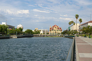
WStockton Channel is in Stockton, California. Stockton Channel runs form the San Joaquin River-Stockton Deepwater Shipping Channel at the Port of Stockton to Downtown Stockton. The Stockton Channel is often called the Stockton Waterfront, and its northeastern arm is known as McLeod Lake. The Channel is about 2.5 miles long and dates back to the 1800s. The Stockton Channel started as the Stockton Slough, a water channel made when the San Joaquin River changed course in the past. McLeod lake is named after Alexander Roderick McLeod a Hudson Bay trappers who came to Stockton to trap beavers in the area. The Stockton Marina is on the Stockton Channel. The Interstate 5 in California crosses the Channel at its midpoint. United States Army Corps of Engineers does once a year maintenance on the Stockton Channel, which requires dredging to remove silt. The Mormon Slough branches off the Stockton Channel. The Stockton Channel is contained by levees. The Miners Levee is on the north side and the Tuleburg Levee on the south side. The Stockton Channel is a small part of the Sacramento–San Joaquin River Delta. The Stockton Channel over flowed its banks in the great flood of 1955. The Smith Channel runs parallel to the north of the Stockton Channel. There was a dam on the Mormon Slough to stop flooding and slit build up in the Stockton Channel. The Dam was removed on 24 October 2016. At the downtown end of the Stockton Channel, there was in the past a creek called Miner Channel. Miner Channel ran between Miner Street and Channel Street. Miner Street sometimes flood, so it was piped and filled in. In 2000 archaeologists did an excavation of the past site of Miner Channel and uncovered artifacts from 1890s to the 1930s. The excavation was done before the new Cineplex complex was built.
 W
WSuisun Bay is a shallow tidal estuary in northern California. It lies at the confluence of the Sacramento River and San Joaquin River, forming the entrance to the Sacramento–San Joaquin River Delta, an inverted river delta. Suisun Marsh, the tidal marsh land to the north, is the largest marsh in California. Grizzly Bay forms a northern extension of Suisun Bay. Suisun Bay is directly north of Contra Costa County.
 W
WThousand Island Lake is a large alpine lake in the Sierra Nevada, within the Ansel Adams Wilderness in eastern Madera County, California.
 W
WThe tule perch Hysterocarpus traskii is a surfperch (Embiotocidae) native to the rivers and estuaries of central California, United States of America. It is the sole member of its genus, and the only freshwater surfperch.