 W
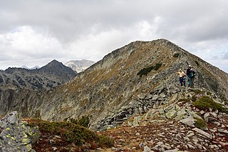
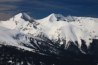
WBanderishki Chukar is a 2,737 m-high peak in the Pirin mountain range, south-western Bulgaria. It is located in the northern part of Pirin on the main mountain ridge. It is the highest granite peak on the main mountain ridge. It is the 12th highest summit in Pirin.
 W
WBanski Suhodol is a peak in the Pirin mountain, south-western Bulgaria. It is located in the northern part of Pirin on the main ridge. Its height is 2,884 m which ranks it on third place in Pirin after Vihren (2,914 m) and Kutelo (2,908 m).
 W
WBashliyski Chukar is a 2,683 m-high peak in the Pirin mountain range, south-western Bulgaria. It is located in the northern part of Pirin and is built up of granite. It is situated on a short ridge stemming from Banderishki Chukar peak (2,732 m) in south-western direction, separating the Malko Spano Pole and Bashliyski cirques.
 W
WBayuvi Dupki is a peak in the Pirin mountain range, south-western Bulgaria. It falls within the borders of the Bayuvi Dupki–Dzhindzhiritsa reserve in Pirin National Park. It is situated on the main ridge of the range between the peaks of Banski Suhodol to the south-east and Kamenititsa to the north-west. Its height is 2,820 m. The eastern slopes descend steeply to the Bayuvi Dupki Cirque, while the western slopes face the valley of the Vlahina river. A tourist eco-path traverses the western slope. The northern face is popular with climbers. The peak is built up of karstified marbles. The summit accommodates many rare herbaceous plants, including edelweiss and the only locality of Euphrasia drosocalyx in the Balkan Peninsula.
 W
WChengelchal is a 2,709 m high peak in the Pirin mountain range, south-western Bulgaria. It is located in the northern part of Pirin on the mountain's main ridge to the south of the summit of Dzhano (2,668 m), with which it is linked via a narrow and rocky saddle known as Malkoto Konche.
 W
WDisilitsa is a 2,700 m high peak in the Pirin mountain range, south-western Bulgaria. It is located on the Polezhan secondary ridge at the end of a stem between Ushitsite and the summit of Kaymakchal (2,753 m) in the south. The slopes of Disilitsa are steep and rocky; they are covered in mountain pine at lower altitude. To the north there is a panoramic view towards the wooded slopes of the Yulen Nature Reserve and the Razlog Valley. To the north-west are located the two Perleshki Lakes and the cirque to the south-east hosts the Pleshivoto Lake, one of the highest in Pirin. The peak is built up of granite.
 W
WDzhano is a 2,668 m high peak in the Pirin mountain range, south-western Bulgaria. It is located in the northern part of Pirin on the mountain's main ridge between Demirkapia Saddle and the summit of Chengelchal (2,709 m) in the south. From Dzhano the main ridge turns in southern direction. To the north the short secondary ridge Dzhangalitsa leads to the summit of Sivria (2,591 m). The north-eastern slopes descent to the Kremenski cirque and the homonymous lakes, to the east is the Kamenishki cirque and to the west — the Demirkapia one. Seen from Popovo Lake the summit appears imposing, though lower than the peaks along the main ridge further south. The peak is built up of porphyry granite blocks and is covered in moraines.
 W
WDzhengal is a peak on the Bulgarian Pirin mountain range. It is situated in one of the external ridges of the mountain, the Polejan Ridge, between the Dzhengal Gate and Momin Dvor Peak and towers to the west of the Popovo Lake. It is 2,730 m high, which places it in the top 10 peaks in the range.
 W
WGazey is a peak in the Pirin mountain, Bulgaria situated on a small sideward ridge of the Polejansli Ridge. It is 2,761 m high, which makes it ninth in the mountain. Viewed from Polejan it looks small, rising slightly above the Upper Polejan lake but its western slopes are dizzy as they descent towards the valley of Damyanitsa. The peak looks majestic from the valley, it can be clearly seen even from the Razlog Valley. Below the larger peak tower a lower one which also looks imposing. The ridge of the same name forms a cirque in which the two Gazey lakes, some of the highest in the Balkans are located as well as the Gazey river. also a word used tto describe one who gazes about much
 W
WKamenitsa is a peak in the Pirin mountain range, south-western Bulgaria. It is located in the northern part of Pirin on the 22 km-long Kamenitsa secondary ridge between the summits of Malka Kamenitsa to the north and Yalovarnika (2,763 m) to the south. Its height is 2,822 m which ranks it on fifth place in Pirin, behind Vihren (2,914 m), Kutelo (2,908 m), Banski Suhodol (2,884 m) and Polezhan (2,851 m). The peak is built up of granite blocks covered in lichens.
 W
WKaymakchal, also known as Izvorets (Изворец) is a peak in the Pirin mountain range, south-western Bulgaria. It is located in the northern part of Pirin on the Polezhan secondary ridge. It is 2,753 m high and is built up of granite.
 W
WKralev Dvor is a 2,680 m high peak in the Pirin mountain range, south-western Bulgaria. It is located on the southern part of the main mountain ridge. It is a pyramidal peak formed by cirque erosion by the glaciers in the cirques of Demir Kapia, Kralev Dvor and Belemeto. Seen from Tevnoto Lake, it has a triangular shape leaning in north-northwestern direction. To the north is located another massive pyramid-shaped summit, Momin Dvor (2,723 m). The two peaks are connected via an easily accessible saddle on the main path between the Bezbog refuge and Tevnoto Lake shelter. To the south the Kamenitsa secondary ridge stems from the main mountain ridge with the summits of Malka Kamenitsa and Kamenitsa Peak (2,822 m).
 W
WKuklite is a 2,686 m-high peak in the Pirin mountain range, south-western Bulgaria. It is located in the northern part of Pirin on the Kamenitsa secondary ridge between the summits of Yalovarnika (2,763 m), Zabat (2,688 m) to the north-east and Golena (2,633 m) to the south. It is built up of granite. The western and north-western slopes of Kuklite are very steep and are open to the pebbly Begovitsa cirque; the foothills contain accumulations of moraines, densely covered in mountain pine at places. The eastern and south-eastern slopes facing the Bashmandra cirque are grassy and oblique. The Begovishko glacial lake is situated at the northern foothills of the summit.
 W
WKutelo is a summit in the Pirin mountain range, southwestern Bulgaria. With a height of 2,908 m it is the second highest peak in Pirin after Vihren (2,914 m), and the third one in Bulgaria, behind Musala (2,925 m) in Rila and Vihren. Kutelo is a double peak with a small saddle between the two parts, the lower being only one meter below the higher one, at 2,907 m. Seen from the town of Bansko it appears higher than Vihren.
 W
WMalak Polezhan is a peak in the northern section of the Pirin mountain range, south-western Bulgaria. Its height is 2,822 m which places it among the top ten summits of Pirin. The peak is built up of granite. Malak Polezhan is situated on the Polezhan side-ward ridge of the range between the peaks of Polezhan (2,851 m) to the north-east and Dzhengal (2,730 m) to the south.
 W
WMomin Dvor is a 2,723 m high peak in the Pirin mountain range, south-western Bulgaria. It is located in the northern part of Pirin on its main ridge between the summits of Kralev Dvor (2,680 m) and Dzhengal (2,730 m). Momin Dvor is pyramid-shaped and was formed by glacial erosion from the three neighbouring cirques: Valyavishki, Popovski and Belemeto. It is built up of porphyry granite.
 W
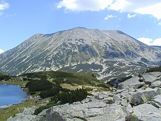
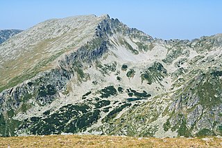
WOrelyak, also known as Orelek or Orlovi skali, is a peak in the Pirin mountain range, south-western Bulgaria. Reaching height of 2,099 m, it is the highest summit of Central Pirin, the second-highest subdivision of the mountain range. Orelayk is situated on Pirin's main ridge to the north of the Baba Peak and to the north-west of the Chala Peak. It has the shape of a triangular dome. The western slopes descend steeply, at places vertically, to the valley of the Pirinska Bistritsa river. Orelayk is built up of karstified marbles. Near its highest point is located a 96 m-high radio and television repeater. The lower part of the northern slopes falls within the territory of the Orelyak Reserve, created to protect the old growth beech forests of Central Pirin.
 W
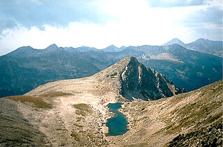
WPolezhan (Bulgarian: Полежан [polɛˈʒan], known pre-1942 as Mangar Tepe is the highest granite peak in the Pirin Mountains and the fourth highest after Vihren, Kutelo and Banski Suhodol. The closest mountain hut is Hizha Bezbog named after Bezbog which lies near Polezhan. Depending on weather conditions the mountain hut is about 2-3h from Polezhan. Two of the highest lakes in Pirin are situated next to Polezhan, namely the Upper Polezhan Lake, the second highest lake in Bulgaria, as well as the Upper Gazei Lake.
 W
WSinanitsa is a marble peak in the northern part of the Pirin Mountains of southwestern Bulgaria. 2,516 metres high, Sinanitsa gives its name to the Sinanitsa Lateral Ridge, one of the four best pronounced lateral ridges in Pirin. Sinanitsa is also known as Chukata, Varovita Chuka or The Split Peak, the latter because of its unusual south face.
 W
WSivria is a 2,591 m high peak in the Pirin mountain range, south-western Bulgaria. It is located in the northern part of Pirin on the Dzhangalitsa ridge that stems from Pirin's main ridge at the summit of Dzhano (2,668 m). The eastern slopes descent to the Kremenski Lakes, while the northern and western slopes descent almost vertically to the Popovski cirque.
 W
WSvesthnik is a 1,975 m peak in the Pirin mountain range, south-western Bulgaria, making it the second highest summit in South Pirin after Ushite (1,978 m). It rises on the main mountain ridge to the south of Popovi Livadi saddle and to the north-west of Ushite. Svesthnik is built up of granite and has a conical shape with rounded steep slopes. Its slopes are covered with forests of Scots pine and Norway spruce, while the summit itself is bare, covered with subalpine herbaceous vegetation.
 W
WTodorka is a massive peak in the Pirin Mountains of south-western Bulgaria. It is the only peak of the Todorka side ridge and has a summit elevation of 2746 m (9009 ft.) above sea level. Todorka is the 11th highest peak in Pirin and is made of granite, and although not rocky, it is steep. It is a relatively short crest with three peaks - Golyama (Big), Sredna (Middle) and Malka (Little) Todorka. Golyama Todorka is located to the north and viewed from the town of Bansko looks like a dramatic pyramid. There are several ski tracks from its slopes, and has been developed extensively since 2000 and is now a major ski area, with a lift-served summit of 2600 m (8530 ft). Bansko hosted World Cup races for the women in 2009 and for the men in 2011.
 W
WUshite is a 1,978 m peak in the Pirin mountain range, south-western Bulgaria, making it the highest summit in South Pirin. It is situated on the main mountain ridge between the peaks of Sveshtnik (1,975 m) and Mutorok (1,971 m). Ushite is covered with forests. In Bulgarian its name means "the ears" and the etymology is linked with the presence of several rock piles on the summit likened to ears.
 W
WVihren is the highest peak of Bulgaria's Pirin Mountains. Reaching 2,914 metres (9,560 ft), it is Bulgaria's second and the Balkans' third highest, after Musala and Mount Olympus. Although due to the karst topography Vihren is deprived of lakes and streams, a number of Pirin's lakes are located around the peak, as is Europe's southernmost glacial mass, the Snezhnika glacielet. Until 1942 Vihren was known as Eltepe ; it was also called Buren (stormy) and Malnienosets (lightning-bringer). The UNESCO World Heritage Site Pirin National Park was originally known as the Vihren National Park. Vihren is included in the 100 Tourist Sites of Bulgaria under No. 2.
 W
WYalovarnika is a 2,763 m-high peak in the Pirin mountain range, south-western Bulgaria. It is located in the northern part of Pirin on the 22 km-long Kamenitsa secondary ridge between the summits of Kamenitsa (2,822 m) to the north and Zabat (2,688 m), Kuklite (2,686 m) and Golena (2,633 m) to the south.