 W
WʻEua is an island in the kingdom of Tonga. It is close to Tongatapu, but forms a separate administrative division. It has an area of 87.44 km2 (33.76 sq mi), and a population in 2016 of 4,945 people.
 W
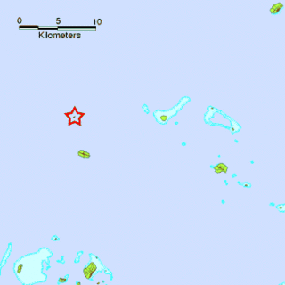
WFatumanongi is an island in Tonga. It is located within the Ha'apai Group in the centre of the country, to the northeast of the national capital of Nukuʻalofa.
 W
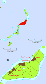
WFoa is an island in Tonga. It is located within the Haʻapai group in the centre of the country, to northeast of the national capital of Nukuʻalofa.
 W
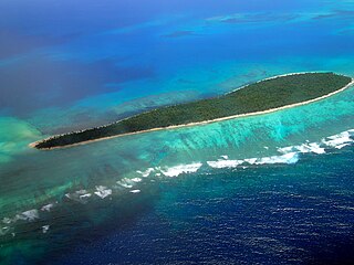
WFonualei is an uninhabited 5 km2 volcanic island close to Vavaʻu in the kingdom of Tonga. It was seen by Don Francisco Mourelle de la Rua on the La Princesa on 26 February 1781. He reported the island to be barren from eruptions, and called it for that reason Amargura.
 W
WHaʻapai is a group of islands, islets, reefs and shoals with an area of 109.30 square kilometres (42.20 sq mi) in the central part of the Kingdom of Tonga, with the Tongatapu group to the south and the Vavaʻu group to the north. Seventeen of the Haʻapai islands are populated with altogether 6,125 people. Its highest point is Kao at almost 1,050 metres (3,440 ft).
 W
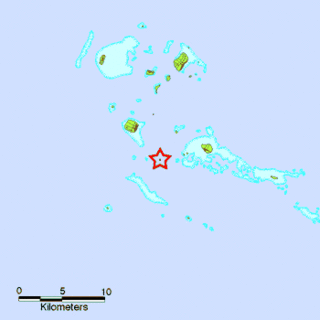
WHunga Tonga-Hunga Haʻapai is a volcanic island located about 30 kilometres south-southeast of Fonuafoʻou island in Tonga. The volcano is part of the highly active Tonga-Kermadec Islands volcanic arc, a subduction zone extending from New Zealand north-northeast to Fiji. It lies about 100 kilometres (62 mi) above a very active seismic zone. The island arc is formed at the convergent boundary where the Pacific Plate subducts under the Indo-Australian Plate.
 W
WKao is an island and stratovolcano in Tonga. It reaches 1,030 m (3,379 ft) above sea level, the highest point in Tonga. Although the island does not display fresh-looking lava flows, it is likely very recent in origin due to the absence of deep gullies or high sea cliffs. Kao lies about 6 km (3.7 mi) north of Tofua island. The slopes of the island rise at angles exceeding 35 degrees to the summit, which has a series of small volcanic craters. An eruption from Kao was reported on July 10, 1847.
 W
WLifuka is an island in the Kingdom of Tonga. It is located within the Haʻapai Group in the centre of the country, to northeast of the national capital of Nukuʻalofa.
 W
WLulunga is an island group and a district in Haʻapai administrative division of the Kingdom of Tonga. The archipelago consists of 17 islands, only 5 of which are inhabited. These are Haʻafeva, Matuku, Kotu, ʻOʻua and Tungua. The population of the whole island chain is nearly 500, most of whom live on Haʻafeva.
 W
WMatuku is a tiny island in Lulunga, a part of Haʻapai in Tonga. It is easily reached by outboard motorboat from the neighbouring hub of Haʻafeva and is on the course from there to the culturally important island of Kotu.
 W
WThe Minerva Reefs are a group of two submerged atolls located in the Pacific Ocean south of Fiji and Tonga.
 W
WNiua is a division of the Kingdom of Tonga, namely the northernmost group of islands. It consists of three islands which together have an area of 71.69 km2 and a population of 1,232. The largest village is Hihifo on Niuatoputapu. Piu'o Tafahi is the highest point with an elevation of 560 m.
 W
WNiuafoʻou is the most northerly island in the kingdom of Tonga. It is a volcanic rim island with an area of 15 km2 (5.8 sq mi) and a population of 650 in 2006. The Niuafoʻou language is spoken on the island.
WNiuatoputapu is a high island in the island nation of Tonga, Pacific Ocean. Its highest point is 157 metres (515 ft), and its area is 16 square kilometres (6.2 sq mi). Its name means sacred island. Older European names for the island are Traitors island or Keppel island.
 W
WNomuka is a small island in the southern part of the Haʻapai group of islands in the Kingdom of Tonga. It is part of the Nomuka Group of islands, also called the ʻOtu Muʻomuʻa.
 W
WNukunamo is an islet which belongs to Foa island, Tonga. It is located within the Ha'apai Group.
 W
WPangaimotu is a small island in the Tongatapu group of Tonga, lying near the capital Nukuʻalofa. It is reachable by a 10-minute boat trip from Nukuʻalofa. Aside from the beaches, a centrepiece of the island's attraction is a wreck jumping from the hull of the upturned ship 50 metres off the island's main beach. The island also contains the Big Mama Yacht Club, the Pangaimotu Island Resort and a vanilla plantation.
 W
WTafahi is a small island in the north of the Tonga archipelago, in fact closer to Savaiʻi (Samoa) than to the main islands of Tonga. It is only 9 km (5.6 mi) north-northeast away from Niuatoputapu, and fishermen commute in small outboard motorboats almost daily between the two. The island has a population of no more than 40.
 W
WTatafa is an islet which belongs to ʻUiha island, Tonga. It is located within the Ha'apai Group.
 W
WTofanga is an islet which belongs to Uonukuhahake island, Tonga. It is located within the Ha'apai Group.
 W
WTofua Caldera is the summit caldera of a steep-sided composite cone that forms Tofua Island in Tonga. Tofua forms part of Tonga's Ha'apai island group.
 W
WTongatapu is the main island of the Kingdom of Tonga and the location of its capital Nukuʻalofa. It is located in Tonga's southern island group, to which it gives its name, and is the country's most populous island, with 74,611 residents (2016), 70.5% of the national population, on 260 square kilometres. Its maximum elevation is 65 metres above sea level. Tongatapu is Tonga's centre of government and the seat of its monarchy.
WUonukuhahake is an island in Lifuka district, in the Ha'apai islands of Tonga.
WUonukuhihifo is an islet which belongs to Uonukuhahake island, Tonga. It is located within the Ha'apai Group.
 W
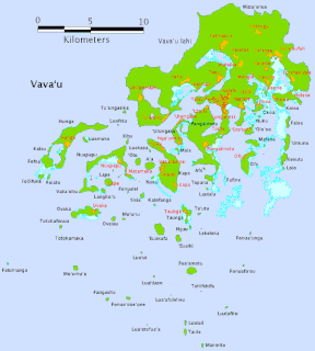
WVavaʻu is the island group of one large island and 40 smaller ones in Tonga. It is part of Vavaʻu District which includes several other individual islands. According to tradition the Maui god finished up both Tongatapu and Vavaʻu, but put a little more effort into the former. Vavaʻu rises 204 metres (669 ft) above sea level at Mount Talau. The capital is Neiafu, situated at the Port of Refuge.