 W
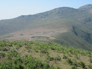
WAnamudi is a mountain located in the Indian state of Kerala. It is the highest peak in the Western Ghats and South India, at an elevation of 2,695 metres (8,842 ft) and a topographic prominence of 2,479 metres (8,133 ft). It lies on the border of Devikulam Taluk, Idukki district and Kothamangalam Taluk, Ernakulam district. The name Anamudi literally translates to "elephant's head" a reference to the resemblance of the mountain to an elephant's head. Anamudi Shola National Park (ASNP) was declared as National Park in December 2003 as per Notification No. 12876/F2 2003/F & WLD dated 14.12.2003 of Government of Kerala
 W
WArma Konda or Sitamma Konda, is a mountain peak in the northern part of the Eastern Ghats and located in Godavari river basin. It is located in the Madugula Konda sub range north of Paderu village in Andhra Pradesh, India.
 W
WBailadila Range, is a mountain range rising in the Deccan Plateau about 200 km west of the Eastern Ghats. It has been named 'Bailadila' because it resembles the hump of an ox. It is located near Kirandul town in the Dantewada district of southern Chhattisgarh, India.
 W
WBetlingchhip, also known as Betalongchhip, Balinchhip and Thaidawr is the highest peak of the Jampui Hills. It is located in the state of Tripura.
 W
WDeomali is a census town in Tirap district in the state of Arunachal Pradesh, India. The small sub-divisional town has scenic beauty and is surrounded by hills, tea gardens, forests and rivers.
 W
WDeomali, is a mountain peak in the Chandragiri-Pottangi subrange of the Eastern Ghats. It is located near Koraput town in the Koraput district of southern Odisha, India.
 W
WMount Dhupgarh or Dhoopgarh is the highest point in the Mahadeo Hills, Madhya Pradesh, India. Located in Pachmarhi, it has an elevation of 1,352 metres (4,429 ft).The top of the hill is a popular area to watch sunsets. Pachmarhi Hill station is located close to the peak.[
 W
WDoddabetta is the highest mountain in the Nilgiri Mountains at 2,637 metres (8,652 feet). There is a reserved forest area around the peak. It is 9 km from Ooty, on the Ooty-Kotagiri Road in the Nilgiris District of Tamil Nadu, India. It is a popular tourist attraction with road access to the summit. It is the fourth highest peak in South India next to Anamudi, Mannamalai and Meesapulimala. The peaks Hecuba, Kattadadu and Kulkudi are the three closely linked summits in the west of the Doddabetta range near to Udagamandalam.
 W
WDoli Gutta is a mountain peak in the northern part of the Deccan Plateau. It is located at the border of Jayashankar Bhupalpally district in Telangana and Bijapur district in Chhattisgarh, India.
 W
WGirinar or Girnar is one of the most ancient Hindu and Jain kshetras in India. It is part of Junagadh town and district in south-western Gujarat, India. Lord Dattatreya performed penance at the top of the hill. This was the kshetra where 22nd Tirthankar, Shri (Lord) Neminath attained nirvana. People have to climb 10,000 steps to have Neminath/Datta paduka darshan.
 W
WGuru Shikhar, a peak in the Arbuda Mountains of Rajasthan, is the highest point of the Aravalli Range. It rises to an elevation of 1,722 metres (5,650 ft). It is 15 km from Mount Abu and a road from there leads almost to the top of the mountain. It is named Guru-Shikhar or 'the peak of the guru' after Dattatreya, an incarnation of Vishnu, and a cave at the summit contains a temple dedicated to him, plus one dedicated his mother, Anasuya, wife of sage Atri nearby.
 W
WHikkim is a village in Lahaul and Spiti district in the northern Indian state of Himachal Pradesh at an elevation of 4,400 m (14,400 ft). It is 46 km (29 mi) from Kaza, the nearest town connected by road. It is one of the highest year-round inhabited locations in India, with residences from 4330 to 4400 m. Tangyud Monastery in adjacent Komic village 2 km to the southeast has residences up to 4520 m, and Korzok Monastery in adjacent Korzok village on Tso Moriri has year-round residences up to 4570 m. Most of the population is Buddhist. People use stones and wood extensively to build houses and structures.
 W
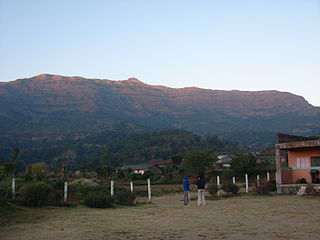
WKalsubai is a mountain in the Western Ghats, located in the Indian state of Maharashtra. Its summit, situated at an elevation of 1,646 metres (5,400 ft), is the highest point in Maharashtra.
 W
WKangchenjunga, also spelled Kanchenjunga, is the third highest mountain in the world. It rises with an elevation of 8,586 m (28,169 ft) in a section of the Himalayas called Kangchenjunga Himal delimited in the west by the Tamur River, in the north by the Lhonak Chu and Jongsang La, and in the east by the Teesta River. It lies between Nepal and Sikkim, India, with three of the five peaks directly on the border, and the remaining two in Nepal's Taplejung District.
 W
WKangto at 7,060 metres (23,163 ft) is a mountain of the Eastern Himalayas located in the Indian state of Arunachal Pradesh and it shares its border with the Tibet Autonomous Region of China. It is the highest point in Arunachal Pradesh. The area in which Kangto is located lies in the Sawa circle of East Kameng district of the state. On the Chinese side, it lies in Cona County of Shannan Prefecture, Tibet.
 W
WKaroh Peak is a 1,467-metre (4,813 ft) tall mountain peak in the Sivalik Hills range of greater Himalayas range located near Morni Hills area of Panchkula district, Haryana, India. It is highest point in the state of Haryana
WMorni is a village and tourist attraction in the Morni Hills at the height of 1,267 metres (4,157 ft) in the Panchkula district of the Indian state of Haryana. It is located around 45 kilometres (28 mi) from Chandigarh, 35 kilometres (22 mi) from Panchkula city and is known for its Himalayan views, flora, and lakes. The name of Morni is believed to derive from a queen who once ruled the area two thousand years back. She was a just and noble ruler of her Queendom and after her the Morni was occupied by the Raja of Morni,kotaha and Pindrawal Raja Mir Syed Muhammad Baquar Ali Khan C.I.E. and he was succeeded by his son Raja Mir Syed Muhammad Jafar Ali Khan II and then he was succeeded by his son Raja Mir Syed Muhammad Akbar Ali Khan II O.B.E and he was succeeded by his three sons Raja Mir Syed Muhammad Kasim Ali Khan III, Raja Mir Syed Muhammad Kazim Ali Khan I and Raja Mir Syed Muhammad Raza Ali Khan I
 W
WMullayanagiri is the highest peak in Karnataka, India. Mullayyanagiri is located at 13°23′26″N 75°43′18″E in the Chandra Dhrona Hill Ranges of the Western Ghats of Chikkamagaluru Taluk. With a height of 1,930 metres (6,330 ft), it is the highest peak in Karnataka. The summit of Mullayanagiri houses a police radio relay station. Seethalayyanagiri is a prominent peak is adjacent to this place.
 W
WNanda Devi is the second highest mountain in India after Kangchenjunga and the highest located entirely within the country. It is the 23rd-highest peak in the world. It was considered the highest mountain in the world before computations in 1808 proved Dhaulagiri to be higher. It was also the highest mountain in India until 1975 when Sikkim, the state in which Kangchenjunga is located, joined the Republic of India. It is part of the Garhwal Himalayas, and is located in Chamoli district of Uttarakhand, between the Rishiganga valley on the west and the Goriganga valley on the east. The peak, whose name means "Bliss-Giving Goddess", is regarded as the patron-goddess of the Uttarakhand Himalaya. In acknowledgment of its religious significance and for the protection of its fragile ecosystem, the peak as well as the circle of high mountains surrounding it—the Nanda Devi sanctuary—were closed to both locals and climbers in 1983. The surrounding Nanda Devi National Park was declared a UNESCO World Heritage Site in 1988.
 W
WParasnath is a mountain peak in the Parasnath Range. It is located towards the eastern end of the Chota Nagpur Plateau in the Giridih district of the Indian state of Jharkhand, India.. The hill is named after Lord Parshvanatha, the 23rd Tirthankara.
 W
WPhawngpui, also known as Blue Mountain is the highest mountain peak in the Mizo Hills and in the state of Mizoram, India, with an elevation of 2157 m. It is located in Lawngtlai district, in the southeastern region of Mizoram near the Myanmar border.
 W
WReo Purgyil, sometimes known as Leo Pargial and Leo Pargil, is a mountain peak at the southern end of the Zanskar Range in the Western Himalaya area of the Himalayas. It is located on the Himachal Pradesh/Tibetan border in the Kinnaur district of Himachal Pradesh, India.
 W
WSandakphu or Sandakpur is the highest peak in the state of West Bengal, India. It is the highest point of the Singalila Ridge in Darjeeling district on the West Bengal-Nepal border. The peak is located at the edge of the Singalila National Park and has a small village on the summit with a few hotels. Four of the five highest peaks in the world, Everest, Kangchenjunga, Lhotse and Makalu can be seen from its summit. It also affords a pristine view of the entire Kangchenjunga Range.
 W
WSaramati is a peak rising above the surrounding peaks at the mountainous border of Nagaland state, India and the Sagaing Region, Burma. It is located near Thanamir Village in the Kiphire district of Nagaland.
 W
WSonsogor is the highest peak in the state of Goa, India, at an elevation of 1,166 metres (3,825 ft) above sea level. It is located in Sattari taluka. It is also called Sonsogodd, Darsingha or Darsinga. It is a part of the Western Ghats mountain range.