 W
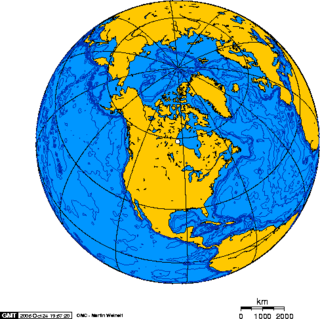
WNorth America is the third largest continent, and is also a portion of the second largest supercontinent if North and South America are combined into the Americas and Africa, Europe, and Asia are considered to be part of one supercontinent called Afro-Eurasia.
 W
WThe following sortable table comprises the 230 mountain peaks of greater North America with at least 100 kilometers of topographic isolation and at least 500 meters of topographic prominence.
WThe following sortable table comprises the 401 mountain peaks of greater North America with at least 3000 meters of elevation and at least 500 meters of topographic prominence.
WThe following sortable table comprises the 124 mountain peaks of greater North America with at least 4000 meters of elevation and at least 500 meters of topographic prominence.
WThe following sortable table comprises the 11 mountain peaks of greater North America with at least 5000 meters of elevation and at least 500 meters of topographic prominence.
 W
WAmerican Nations: A History of the Eleven Rival Regional Cultures of North America is an American non-fiction book written by Colin Woodard and published in 2011. Woodard proposes a framework for examining American history and current events based on a view of the country as a federation of eleven nations, each defined by a shared culture established by each nation's founding population.
 W
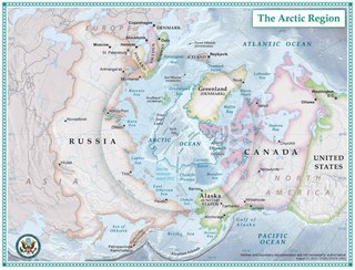
WThe Arctic is a polar region located at the northernmost part of Earth. The Arctic consists of the Arctic Ocean, adjacent seas, and parts of Alaska, Canada, Finland, Greenland (Denmark), Iceland, Norway, Russia, and Sweden. Land within the Arctic region has seasonally varying snow and ice cover, with predominantly treeless permafrost containing tundra. Arctic seas contain seasonal sea ice in many places.
 W
WThe North American Arctic is composed of the northern portions of Alaska (USA), Northern Canada and Greenland. Major bodies of water include the Arctic Ocean, Hudson Bay, the Gulf of Alaska and North Atlantic Ocean. The North American Arctic lies above the Arctic Circle. It is part of the Arctic, which is the northernmost region on Earth. The western limit is the Seward Peninsula and the Bering Strait. The southern limit is the Arctic Circle latitude of 66° 33’N, which is the approximate limit of the midnight sun and the polar night.
 W
WThe Bering Strait is a strait of the Pacific, which separates Russia and the United States slightly south of the Arctic Circle at about 65° 40' N latitude. The present Russia-US east–west boundary is at 168° 58' 37" W. The Strait is named after Vitus Bering, a Danish explorer in the service of the Russian Empire.
 W
WThe Continental Divide of the Americas is the principal, and largely mountainous, hydrological divide of the Americas. The Continental Divide extends from the Bering Strait to the Strait of Magellan, and separates the watersheds that drain into the Pacific Ocean from those river systems that drain into the Atlantic Ocean and, along the northernmost reaches of the Divide, those river systems that drain into the Arctic Ocean and Hudson Bay.
 W
WThis list of North American deserts identifies areas of the continent that receive less than 10 in (250 mm) annual precipitation. The "North American Desert" is also the term for a large U.S. Level 1 ecoregion (EPA) of the North American Cordillera, in the Deserts and xeric shrublands biome (WWF). The continent's deserts are largely between the Rocky Mountains and Sierra Madre Oriental on the east, and the rain shadow-creating Sierra Nevada, Transverse, and Peninsular Ranges on the west. The North American xeric region of over 95,751 sq mi (247,990 km2) includes: three major deserts; numerous smaller deserts; and large non-desert arid regions; in the western United States and in northeast, central, and northwest Mexico.
 W
WThis is a list of the extreme points of North America: the points that are highest and lowest, and farther north, south, east or west than any other location on the continent. Some of these points are debatable, given the varying definitions of North America.
WThis article comprises four sortable tables of mountain summits of greater North America that are the higher than any other point north or south of their latitude or east or west their longitude in North America.
 W
WThe Gonâve Microplate forms part of the boundary between the North American Plate and the Caribbean Plate. It is bounded to the west by the Mid-Cayman Rise spreading center, to the north by the Septentrional-Oriente fault zone and to the south by the Walton fault zone and the Enriquillo–Plantain Garden fault zone. The existence of this microplate was first proposed in 1991. This has been confirmed by GPS measurements, which show that the overall displacement between the two main plates is split almost equally between the transform fault zones that bound the Gonâve microplate. The microplate is expected to eventually become accreted to the North American Plate.
WThe following sortable table comprises the 200 highest mountain peaks of greater North America with at least 500 meters of topographic prominence.
 W
WThe Insular Islands were a giant chain of active volcanic islands somewhere in the Pacific Ocean during the Cretaceous period that rode on top a microplate called the Insular Plate, beginning around 130 million years ago. The Insular Islands were surrounded by two prehistoric oceans, the Panthalassa Ocean to the west and the Bridge River Ocean to the east. About 115 million years ago, these islands collided with the North American continent, fusing onto the North American Plate and closing the Bridge River Ocean during the Mid-Cretaceous time.
 W
WThe following sortable table comprises the 76 highest ocean islands of greater North America. Each of these islands rises at least 1000 meters above the sea.
WThe following sortable table comprises the 200 most topographically isolated mountain peaks of greater North America with at least 500 meters of topographic prominence.
WThe Laurentian Divide also called the Northern Divide and locally the height of land, is a continental divide in central North America that separates the Hudson Bay watershed to the north from the Gulf of Mexico watershed to the south and the Great Lakes-St. Lawrence watershed to the southeast.
 W
WThe Maritime Peninsula is a region of eastern North America that extends from the Kennebec River in the U.S. state of Maine northeast to the Maritime provinces of Canada and Quebec's Gaspé Peninsula. It is bounded by the Gulf of Saint Lawrence to the north and the Gulf of Maine to the south.
WThis article comprises three sortable tables of major mountain peaks of greater North America.
 W
WThe Pacific Coast Ranges, are the series of mountain ranges that stretch along the West Coast of North America from Alaska south to Northern and Central Mexico.
 W
WPortages in North America usually began as animal tracks and were improved by tramping or blazing. In a few places iron-plated wooden rails were laid to take a handcart. Heavily used routes sometimes evolved into roads when sledges, rollers or oxen were used, as at Methye Portage. Sometimes railways were built. The basic purpose of most canals is to avoid portages.
WThe following sortable tables comprise the most topographically prominent mountain peaks of greater North America. Each of these 353 summits has at least 1500 meters of topographic prominence.
WThe following sortable tables comprise the most topographically prominent mountain peaks of greater North America. Each of these 353 summits has at least 1500 meters of topographic prominence.