 W
WThe Azolla event is a scenario hypothesized to have occurred in the middle Eocene epoch, around 49 million years ago, when blooms of the freshwater fern Azolla are thought to have happened in the Arctic Ocean. As they sank to the stagnant sea floor, they were incorporated into the sediment; the resulting draw-down of carbon dioxide has been speculated to have helped transform the planet from a "greenhouse Earth" state, hot enough for turtles and palm trees to prosper at the poles, to the current icehouse Earth known as the Late Cenozoic Ice Age.
 W
WThe Campanian Ignimbrite eruption was a major volcanic eruption in the Mediterranean during the late Quaternary, classified at 7 on the Volcanic Explosivity Index (VEI). The event has been attributed to the Archiflegreo volcano, the 13-kilometre-wide (8.1 mi) caldera of the Phlegraean Fields, located 20 km (12 mi) west of Mount Vesuvius under the western outskirts of the city of Naples and the Gulf of Pozzuoli, Italy. Estimates of the date, magnitude and the amount of ejected material have varied considerably during several centuries of investigation. This applies to most significant volcanic events that originated in the Campanian Plain, as it is one of the most complex volcanic structures in the world. However, continued research, advancing methods and accumulation of volcanological, geochronological, and geochemical data has amounted to ever more precise dating.
 W
WThe Cretaceous–Paleogene (K–Pg) boundary, formerly known as the Cretaceous–Tertiary (K-T) boundary, is a geological signature, usually a thin band of rock. The K–Pg boundary marks the end of the Cretaceous Period, the last period of the Mesozoic Era, and marks the beginning of the Paleogene Period, the first period of the Cenozoic Era. Its age is usually estimated at around 66 Ma, with radiometric dating yielding a more precise age of 66.043 ± 0.011 Ma.
 W
WThe Cretaceous–Paleogene (K–Pg) extinction event, also known as the Cretaceous–Tertiary (K–T) extinction, was a sudden mass extinction of three-quarters of the plant and animal species on Earth, approximately 66 million years ago. With the exception of some ectothermic species such as the sea turtles and crocodilians, no tetrapods weighing more than 25 kilograms survived. It marked the end of the Cretaceous period, and with it the end of the entire Mesozoic Era, opening the Cenozoic Era that continues today.
 W
WThe Deccan Traps is a large igneous province of west-central India. They are one of the largest volcanic features on Earth. They consist of multiple layers of solidified flood basalt that together are more than 2,000 m (6,600 ft) thick, cover an area of c. 500,000 km2 (200,000 sq mi), and have a volume of c. 1,000,000 km3 (200,000 cu mi). Originally, the Deccan Traps may have covered c. 1,500,000 km2 (600,000 sq mi), with a correspondingly larger original volume.
 W
WThe Hatepe eruption, named for the Hatepe Plinian pumice tephra layer, sometimes referred to as the Taupo eruption and dated to either around AD 180 or 233 was Taupo Volcano's most recent major eruption. It is considered New Zealand's largest eruption during the last 20,000 years. The eruption ejected some 120 km3 (29 cu mi) of material, of which 30 km3 (7.2 cu mi) was ejected in a few minutes. This makes it one of the most violent eruptions in the last 5,000 years, comparable to the Minoan eruption in the 2nd millennium BC, the 946 eruption of Paektu Mountain and the 1815 eruption of Mount Tambora.
 W
WHuaynaputina is a stratovolcano in a volcanic upland in southern Peru. Part of the Central Volcanic Zone of the Andean Volcanic Belt, it is the product of the subduction of the oceanic Nazca tectonic plate beneath the continental part of the South American tectonic plate at a rate of 10.3 centimetres per year (4.1 in/year). Huaynaputina is a large volcanic crater, lacking an identifiable mountain profile, with an outer stratovolcano and three younger volcanic vents. The vents of Huaynaputina form a north-northwest–south-southeast trend.
WHuaynaputina is a stratovolcano in a volcanic upland in southern Peru. Part of the Central Volcanic Zone of the Andean Volcanic Belt, it is the product of the subduction of the oceanic Nazca tectonic plate beneath the continental part of the South American tectonic plate at a rate of 10.3 centimetres per year (4.1 in/year). Huaynaputina is a large volcanic crater, lacking an identifiable mountain profile, with an outer stratovolcano and three younger volcanic vents. The vents of Huaynaputina form a north-northwest–south-southeast trend.
 W
WThe Island Park Caldera, in the U.S. states of Idaho and Wyoming, is one of the world's largest calderas, with approximate dimensions of 80 by 65 km. Its ashfall is the source of the Huckleberry Ridge Tuff that is found from southern California to the Mississippi River near St. Louis. This super-eruption of approximately 2,500 km3 (600 cu mi) occurred 2.1 Ma and produced 2,500 times as much ash as the 1980 eruption of Mount St. Helens. Island Park Caldera has the smaller and younger Henry's Fork Caldera nested inside it.
 W
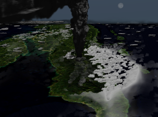
WThe 1883 eruption of Krakatoa in the Sunda Strait began on the afternoon of Sunday, 26 August 1883—with origins as early as that May—and peaked on the late morning of Monday, 27 August 1883, when over 70% of the island of Krakatoa and its surrounding archipelago were destroyed as it collapsed into a caldera.
 W
WKuwae is a submarine caldera between the Epi and Tongoa islands in Vanuatu. Kuwae Caldera cuts through the flank of the Tavani Ruru volcano on Epi and the northwestern end of Tongoa.
 W
WLaki or Lakagígar is a volcanic fissure in the western part of Vatnajökull National Park, Iceland, not far from the volcanic fissure of Eldgjá and the small village of Kirkjubæjarklaustur. The fissure is properly referred to as Lakagígar, while Laki is a mountain that the fissure bisects. Lakagígar is part of a volcanic system centered on the volcano Grímsvötn and including the volcano Thordarhyrna. It lies between the glaciers of Mýrdalsjökull and Vatnajökull, in an area of fissures that run in a southwest to northeast direction.
WLaki or Lakagígar is a volcanic fissure in the western part of Vatnajökull National Park, Iceland, not far from the volcanic fissure of Eldgjá and the small village of Kirkjubæjarklaustur. The fissure is properly referred to as Lakagígar, while Laki is a mountain that the fissure bisects. Lakagígar is part of a volcanic system centered on the volcano Grímsvötn and including the volcano Thordarhyrna. It lies between the glaciers of Mýrdalsjökull and Vatnajökull, in an area of fissures that run in a southwest to northeast direction.
 W
WThe Mid-Pleistocene Transition (MPT), also known as the Mid-Pleistocene Revolution (MPR), is a fundamental change in the behaviour of glacial cycles during the Quaternary glaciations. The transition happened approximately 1.25–0.7 million years ago, in the Pleistocene epoch. Before the MPT, the glacial cycles were dominated by a 41,000 year periodicity with low-amplitude, thin ice sheets and a linear relationship to the Milankovitch forcing from axial tilt. After the MPT there have been strongly asymmetric cycles with long-duration cooling of the climate and build-up of thick ice sheets, followed by a fast change from extreme glacial conditions to a warm interglacial. The cycle lengths have varied, with an average length of approximately 100,000 years.
 W
WThe Minoan eruption was a major catastrophic volcanic eruption that devastated the Aegean island of Thera in around 1600 BCE. It destroyed the Minoan settlement at Akrotiri, as well as communities and agricultural areas on nearby islands and the coast of Crete with subsequent earthquakes and tsunamis. With a VEI magnitude between 6 and 7, resulting in an ejection of approximately 60 km3 (14 cu mi) of dense-rock equivalent (DRE), the eruption was one of the largest volcanic events on Earth in human history.
 W
WThe 1808 mystery eruption was a large volcanic eruption conjectured to have taken place in late 1808, possibly in the southwest Pacific. A VEI-6 eruption, comparable to the 1883 eruption of Krakatoa, is suspected of having contributed to a period of global cooling that lasted for years, analogous to how the 1815 eruption of Mount Tambora (VEI-7) led to the Year Without a Summer in 1816.
 W
WThe Oruanui eruption of New Zealand's Taupo Volcano, the world's most recent supereruption, had a Volcanic Explosivity Index of 8. It is one of the largest eruptions in the history of New Zealand. It occurred about 26,500 years ago in the Late Pleistocene and generated approximately 430 km3 (100 cu mi) of pyroclastic fall deposits, 320 km3 (77 cu mi) of pyroclastic density current (PDC) deposits and 420 km3 (100 cu mi) of primary intracaldera material, equivalent to 530 km3 (130 cu mi) of magma, totaling 1,170 km3 (280 cu mi) of total deposits. The eruption is divided into 10 different phases on the basis of nine mappable fall units and a tenth, poorly preserved but volumetrically dominant fall unit.
 W
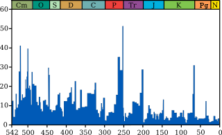
WThe Permian–Triassic extinction event, also known as the P–Tr extinction, the P–T extinction, the End-Permian Extinction, and colloquially as the Great Dying, formed the boundary between the Permian and Triassic geologic periods, as well as between the Paleozoic and Mesozoic eras, approximately 251.9 million years ago. It is the Earth's most severe known extinction event, with up to 96% of all marine species and 70% of terrestrial vertebrate species becoming extinct. It was the largest known mass extinction of insects. Some 57% of all biological families and 83% of all genera became extinct.
 W
WThe 1991 eruption of Mount Pinatubo in the Philippines' Luzon Volcanic Arc was the second-largest volcanic eruption of the 20th century, behind only the 1912 eruption of Novarupta in Alaska. Eruptive activity began on April 2 as a series of phreatic explosions from a fissure that opened on the north side of Mount Pinatubo. Seismographs were set up and began monitoring the volcano for earthquakes. In late May, the number of seismic events under the volcano fluctuated from day-to-day. Beginning June 6, a swarm of progressively shallower earthquakes accompanied by inflationary tilt on the upper east flank of the mountain, culminated in the extrusion of a small lava dome.
 W
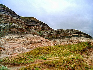
WThe Quaternary period has seen the extinctions of numerous predominantly megafaunal species, which have resulted in a collapse in faunal density and diversity and the extinction of key ecological strata across the globe. The most prominent event in the Late Pleistocene is differentiated from previous Quaternary pulse extinctions by the widespread absence of ecological succession to replace these extinct species, and the regime shift of previously established faunal relationships and habitats as a consequence.
 W
WIn 1257, a catastrophic eruption occurred at Samalas volcano on the Indonesian island of Lombok. The event had a probable Volcanic Explosivity Index of 7, making it one of the largest volcanic eruptions during the current Holocene epoch. It created eruption columns reaching tens of kilometres into the atmosphere and pyroclastic flows that buried much of Lombok and crossed the sea to reach the neighbouring island of Sumbawa. The flows destroyed human habitations, including the city of Pamatan, which was the capital of a kingdom on Lombok. Ash from the eruption fell as far as 340 kilometres (210 mi) away in Java; the volcano deposited more than 10 cubic kilometres (2.4 cu mi) of rocks and ash.
 W
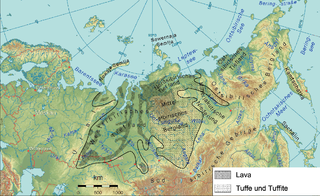
WThe Siberian Traps is a large region of volcanic rock, known as a large igneous province, in Siberia, Russia. The massive eruptive event that formed the traps is one of the largest known volcanic events in the last 500 million years.
 W
WThe 1815 eruption of Mount Tambora was the most powerful volcanic eruption in recorded human history, with a Volcanic Explosivity Index (VEI) of 7. The eruption ejected 160–180 cubic kilometres (38–43 cu mi) of material into the atmosphere. It is the most recently known VEI-7 event and the most recent confirmed VEI-7 eruption.
 W
WThe Youngest Toba eruption was a supervolcanic eruption that occurred around 75,000 years ago at the site of present-day Lake Toba in Sumatra, Indonesia. It is one of the Earth's largest known explosive eruptions. The Toba catastrophe theory holds that this event caused a global volcanic winter of six to ten years and possibly a 1,000-year-long cooling episode.
 W
WThe year 1816 is known as the Year Without a Summer because of severe climate abnormalities that caused average global temperatures to decrease by 0.4–0.7 °C (0.7–1 °F). Summer temperatures in Europe were the coldest on record between the years of 1766–2000. This resulted in major food shortages across the Northern Hemisphere.