 W
WThe Neotropical realm is one of the eight biogeographic realms constituting Earth's land surface. Physically, it includes the tropical terrestrial ecoregions of the Americas and the entire South American temperate zone.
 W
WThe Alto Paraná Atlantic forests, also known as the Paraná-Paraíba interior forests, is an ecoregion of the tropical moist forests biome, and the South American Atlantic Forest biome. It is located in southern Brazil, northeastern Argentina, and eastern Paraguay.
 W
WThe Amazon biome contains the Amazon rainforest, an area of tropical rainforest, and other ecoregions that cover most of the Amazon basin and some adjacent areas to the north and east. The biome contains blackwater and whitewater flooded forest, lowland and montane terra firme forest, bamboo and palm forest, savanna, sandy heath and alpine tundra. Some areas are threatened by deforestation for timber and to make way for pasture or soybean plantations.
 W
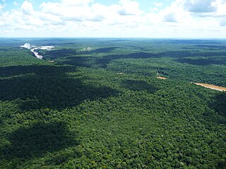
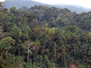
WThe Amazon rainforest, alternatively, the Amazon Jungle, also known in English as Amazonia, is a moist broadleaf tropical rainforest in the Amazon biome that covers most of the Amazon basin of South America. This basin encompasses 7,000,000 km2 (2,700,000 sq mi), of which 5,500,000 km2 (2,100,000 sq mi) are covered by the rainforest. This region includes territory belonging to nine nations.
 W
WThe Amazon-Orinoco-Southern Caribbean mangroves (NT1401) is an ecoregion along the coasts of Colombia, Venezuela, Guyana, Suriname, French Guiana and Brazil.
 W
WThe Cerrado is a vast tropical savanna ecoregion of Brazil, particularly in the states of Goiás, Mato Grosso do Sul, Mato Grosso, Tocantins, Minas Gerais and the Federal District. The core areas of the Cerrado biome are the Brazilian highlands, the Planalto. The main habitat types of the Cerrado consist of forest savanna, wooded savanna, park savanna and gramineous-woody savanna. Savanna wetlands and gallery forests are also included. The second largest of Brazil's major habitat types, after the Amazonian rainforest, the Cerrado accounts for a full 21 percent of the country's land area.
 W
WThe Gran Chaco or Dry Chaco is a sparsely populated, hot and semiarid lowland natural region of the Río de la Plata basin, divided among eastern Bolivia, western Paraguay, northern Argentina, and a portion of the Brazilian states of Mato Grosso and Mato Grosso do Sul, where it is connected with the Pantanal region. This land is sometimes called the Chaco Plain.
 W
WThe Guajira-Barranquilla xeric scrub is a xeric shrubland ecoregion in Colombia, Venezuela, and the ABC Islands, covering an estimated area of 150,000 km2 (58,000 sq mi). Rainfall varies from 125 to 600 mm, and the median temperature is 37 °C (99 °F).
 W
WThe Humid Chaco is tropical grasslands, savannas, and shrublands ecoregion in South America. It lies in the basin of the Paraná River, covering portions of central Paraguay and northern Argentina, and with a small portion extending into southwestern Brazil. The natural vegetation is a mosaic of grasslands, palm savanna, and forest.
 W
WThe Llanos is a vast tropical grassland plain situated to the east of the Andes in Colombia and Venezuela, in northwestern South America. It is an ecoregion of the tropical and subtropical grasslands, savannas, and shrublands biome.
 W
WThe Venezuelan Llanos also simply known as Los Llanos in Venezuela, is a large central depression very flat in a vast natural region of approximately 243,774 km2 of extension, equivalent to 26.6% of the total continental territory of the country.
 W
WThe Magellanic moorland or Magellanic tundra is an ecoregion on the Patagonian archipelagos south of latitude 48° S. It is characterized by high rainfall with a vegetation of scrubs, bogs and patches of forest in more protected areas. Cushion plants, grass-like plants and bryophytes are common.
 W
WThe Magellanic subpolar forests are a terrestrial ecoregion of southernmost South America, covering parts of southern Chile and Argentina, and are part of the Neotropical realm. It is a temperate broadleaf and mixed forests ecoregion, and contains the world's southernmost forests.
 W
WMaulino forest is a forest type naturally growing in the Chilean Coast Range of Central Chile from latitude 35°55 to 36°20 S. The chief tree species is Nothofagus glauca. Other tree species include Nothofagus leonii, Nothofagus alessandri and Gomorterga keule. The forest grows at a transition zone between Mediterranean climate to humid temperate climate. Precipitations vary from 1000 to 700 mm/a and are concentrated in winter. According to geographers Humberto Fuenzalida and Edmundo Pisano the forest is one of mesophytes on the transition zone of temperate rain forests.
 W
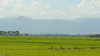
WThe Pampas are fertile South American lowlands that cover more than 1,200,000 square kilometres (460,000 sq mi) and include the Argentine provinces of Buenos Aires, La Pampa, Santa Fe, Entre Ríos, and Córdoba; all of Uruguay; and Brazil's southernmost state, Rio Grande do Sul. The vast plains are a natural region, interrupted only by the low Ventana and Tandil hills, near Bahía Blanca and Tandil (Argentina), with a height of 1,300 m (4,265 ft) and 500 m (1,640 ft), respectively.
 W
WThe Pantanal is a natural region encompassing the world's largest tropical wetland area, and the world's largest flooded grasslands. It is located mostly within the Brazilian state of Mato Grosso do Sul, but it extends into Mato Grosso and portions of Bolivia and Paraguay. It sprawls over an area estimated at between 140,000 and 195,000 square kilometres. Various subregional ecosystems exist, each with distinct hydrological, geological and ecological characteristics; up to 12 of them have been defined.
 W
WPáramo can refer to a variety of alpine tundra ecosystems. Some ecologists describe the páramo broadly as "all high, tropical, montane vegetation above the continuous timberline". A more narrow term classifies the páramo according to its regional placement in the northern Andes of South America and adjacent southern Central America. The páramo is the ecosystem of the regions above the continuous forest line, yet below the permanent snowline. It is a "Neotropical high mountain biome with a vegetation composed mainly of giant rosette plants, shrubs and grasses". According to scientists, páramos may be "evolutionary hot spots" and among the fastest evolving regions on Earth.
 W
WThe Patagonian grasslands (NT0804) is an ecoregion in the south of Chile, Argentina and the Falkland Islands. The grasslands are home to diverse fauna, including several rare or endemic species of birds. There are few protected areas. The grasslands are threatened by overgrazing by sheep, which supply high-quality merino wool. Efforts are being made to develop sustainable grazing practices to avoid desertification.
 W
WPeruvian Amazonia is the area of the Amazon rainforest included within the country of Peru, from east of the Andes to the borders with Ecuador, Colombia, Brazil and Bolivia. This region comprises 60% of the country and is marked by a large degree of biodiversity. Peru has the second-largest portion of the Amazon rainforest after the Brazilian Amazon.
 W
WThe Rupununi is a savanna plain in Guyana, in the Upper Takutu-Upper Essequibo region. It is an ecoregion of the Tropical and subtropical grasslands, savannas, and shrublands Biome.
 W
WA tepui, or tepuy, is a table-top mountain or mesa found in the Guiana Highlands of South America, especially in Venezuela and western Guyana. The word tepui means "house of the gods" in the native tongue of the Pemon, the indigenous people who inhabit the Gran Sabana.
 W
WThe Tropical Andes is northern of the three climate-delineated parts of the Andes, the others being the Dry Andes and the Wet Andes. The Tropical Andes' area spans 1,542,644 km2 (595,618 sq mi).
 W
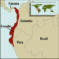
WTumbes-Chocó-Magdalena is a biodiversity hotspot, which includes the tropical moist forests and tropical dry forests of the Pacific coast of South America and the Galapagos Islands. The region extends from easternmost Panama to the lower Magdalena Valley of Colombia, and along the Pacific coast of Colombia and Ecuador to the northwestern corner of Peru. Formerly called the Chocó-Darién-Western Ecuador Hotspot, it has been expanded to include several new areas, notably the Magdalena Valley in northern Colombia. It is bounded on the east by the Andes Mountains. The Tumbes-Choco-Magdalena Hotspot is 1,500 km long and encircles 274,597 km². Tumbes-Choco-Magdalena is near the Pacific Ocean. The factors that threaten Tumbes-Choco-Magdalena are farming encroachment, deforestation, illegal crops, and population growth. Whereas the Panamanian and Colombian portion of the hotspot are relatively intact, approximately 98% of native forest in coastal Ecuador has been cleared, rendering it the most threatened tropical forest in the world. The hotspot includes a wide variety of habitats, ranging from mangroves, beaches, rocky shorelines, and coastal wilderness to some of the world's wettest rain forests in the Colombian Chocó. The hotspot includes a number of ecoregions:Chocó-Darién moist forests Ecuadorian dry forests (Ecuador) Guayaquil flooded grasslands (Ecuador) Gulf of Guayaquil-Tumbes mangroves Galápagos Islands xeric scrub (Ecuador) Magdalena Valley montane forests (Colombia) Magdalena-Urabá moist forests (Colombia) Manabí mangroves (Ecuador) Tumbes-Piura dry forests Piura mangroves (Peru) Western Ecuador moist forests
 W
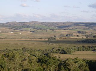
WThe Uruguayan savanna, also known as the Brazilian-Uruguayan savanna, is a subtropical grassland and savanna ecoregion which includes all of Uruguay, some areas of northeastern Argentina and southernmost Brazil.
 W
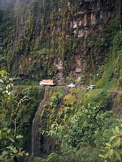
WThe Yungas is a narrow band of forest along the eastern slope of the Andes Mountains from Peru, Bolivia, and northern Argentina. It is a transitional zone between the Andean highlands and the eastern forests. Like the surrounding areas, the Yungas belong to the Neotropical realm; the climate is rainy, humid, and warm.