 W
WCapella Island is a 230-acre (0.93 km2) uninhabited island that is owned by the United States Virgin Islands. It is located about 2 miles (4 km) south of the island of St. Thomas. It is adjacent to Buck Island, home of Buck Island National Wildlife Refuge, about twice the size of Capella. Together Capella, Buck, and associated islets are sometimes referred to as the Capella Islands.
 W
WCas Cay is a fifty-acre (200,000-square-metre) undeveloped island, situated a mile south of Red Hook on the eastern side of Saint Thomas in the United States Virgin Islands. It is under the protection of the Department of Natural Resources. Ferries here depart from Compass Point Marina, right east of Nadir. It is a tropical island, which has a hundred feet tall hill with bird species such as the Red-billed- and White-tailed tropicbird. It is also home to endemic plant species such as orchids, Tabebuia, gumbo-limbos, as well as the seagrape, manchineel and numerous mangroves. It is home to lizards such as anoles, ameiva and geckos. The island has a high density of rats as well. It has a mangrove lagoon and is one of the largest mangrove areas in the Virgin Islands. Besides the mangrove ecosystem, the wildlife sanctuary, the natural whirlpool and blowhole, many visit the island for recreational activities such as snorkeling, scuba diving, kayaking and bird watching. The nearby Cas Cay-Mangrove Lagoon Marine Reserve & Wildlife Sanctuary is located in the Jersey Bay immediately north of Cas Cay.
 W
WGrass Cay is an island of the United States Virgin Islands.
 W
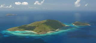
WGreat Saint James is an island of the United States Virgin Islands, located off the east end of St. Thomas and belongs to subdistrict East End, Saint Thomas. The island is approximately 165 acres (67 ha) in size, and is located 0.4 kilometres (0.25 mi) southeast of Saint Thomas. There is one estate on Great Saint James. The island has most notably been owned by financier and sex offender Jeffrey Epstein, along with the neighboring Little Saint James island.
 W
WThe Hans Lollik Islands are two islands in the US Virgin Islands. Great Hans Lollik Island ("GHL") is found approximately 8,000 feet beyond the central northshore of St. Thomas, US Virgin Islands, separated from St. Thomas by the Leeward Passage. Little Hans Lollik and Pelican Cay lie to the north of Hans Lollik on the same shelf. The major part of the benthic zone around Hans Lollik is rocky and supports a dense diverse coral habitat.
 W
WHassel Island is a small island of the U.S. Virgin Islands, a United States territory located in the Caribbean Sea. Hassel Island lies in the Charlotte Amalie harbor just south of Saint Thomas and east of Water Island, with which it is part of the sub-district of Water Island.
 W
WInner Brass Island is a 130-acre undeveloped tropical Caribbean island, situated 0.4 miles north off the Nordside of Saint Thomas in the United States Virgin Islands. There is a resort site located here, along with white sandy beaches, tropical reefs, and also a helicopter pad. It is reached by boat or kayaking from St. Thomas' north shore.
WKalkun Cay is a rocky, steep and narrow islet, located in the middle of the Savana Passage in the United States Virgin Islands. It is one mile northeast of Savana Island and one mile west of West Point on the island of Saint Thomas. Kalkun Cay is 73 feet high and covered with underbrush and grass. It is an important habitat of native seabirds.
 W
WLeduck Island is an island in the United States Virgin Islands, also spelled LeDuck Island, which is located 0.5 miles east of Sabbat Point in Johns Folly, separated from Saint John by the Sabbat Channel. LeDuck Island lies by the entrance to Coral Bay and is 85 feet high. Leduck Island is located within the Virgin Islands National Park and is one of the largest offshore islands to Saint John, along with Grass Cay and Congo Cay.
 W
WLittle Saint James is a small private island of the United States Virgin Islands, located southeast of neighboring Great Saint James, both off the southern coast of the larger St. Thomas island, and belongs to the subdistrict East End, Saint Thomas. The 70–78 acres (28–32 ha) island was owned by American convicted child sex offender Jeffrey Epstein from 1998 until his 2019 death. During Epstein's ownership, the island acquired local nicknames such as "Island of Sin" and "Pedophile Island," as it was alleged to be a location where sexual abuse of underage girls occurred.
WLovango Cay is a private island of the district of Saint John, in the United States Virgin Islands.
WMingo Cay is an island part of Central sub-district, in Saint John, United States Virgin Islands. It is located between Saint Thomas and Saint John.
WOuter Brass is an island of the United States Virgin Islands, located off of Nordside, St. Thomas.
 W
WProtestant Cay is a four-acre triangular islet in the Christiansted Harbor, 200 yards north of Christiansted. It has the closest beach to Downtown Christiansted. The island is home to a resort, the Hotel on the Cay, which is home to a protected sand beach, small shop and beach bar. The ferries to Protestant Cay are free of charge and leave from King’s Wharf in Christiansted.
WRamgoat Cay is an islet in the United States Virgin Islands, located 310 yards northeast of Henley Cay and 1300 feet north of Hawksnest Point on the island of Saint John. It is 30 feet high and located within the Virgin Islands National Park.
WRuth Island is an artificial island off the southern coast of Saint Croix, U.S. Virgin Islands near Port Alucroix. It was created in the mid-1960s from the dredging of Krauses Lagune and is about 40 acres (16 ha).
 W
WSaint Croix is an island in the Caribbean Sea, and a county and constituent district of the United States Virgin Islands (USVI), an unincorporated territory of the United States.
 W
WSaint John is one of the Virgin Islands in the Caribbean Sea and a constituent district of the United States Virgin Islands (USVI), an unincorporated territory of the United States.
 W
WSaint Thomas is one of the Virgin Islands in the Caribbean Sea which, together with Saint John, Water Island, Hassel Island, and Saint Croix, form a county and constituent district of the United States Virgin Islands (USVI), an unincorporated territory of the United States. Located on the island is the territorial capital and port of Charlotte Amalie. As of the 2010 census, the population of Saint Thomas was 51,634, about 48.5% of the US Virgin Islands total. The district has a land area of 32 square miles (83 km2).
 W
WSavana Island is an islet of the United States Virgin Islands. It is located off the West End of St. Thomas at 18°20'N 65°05'W, approximately 7 miles west of Cyril E. King Airport..
WThatch Cay is a small, uninhabited 230 acre island one-half mile off the northeastern coast of Saint Thomas. Its highest peak is 482 feet. It is one of the last privately held, undeveloped islands in the U.S. Virgin Islands.
WTurtledove Cay is a rocky 3.78 acre islet, located 100 yards north of Saba Island in the United States Virgin Islands. Its elevation is 50 feet and the islet is covered with tall grass. It is joined with Saba Island by a reef, which is bare at times of extremely low water. Turtledove Cay are all designated wildlife reserves by the territorial U.S.V.I. government. Turtledove Cay is home to large quantities of native avifauna, including large colonies of noddies and other seabirds.
WWater Island, U.S. Virgin Islands was acquired by the USA in 1917 from Denmark but continued to be owned by the Danish East Asiatic Company until several decades later. Since 1996, it has formed part of the United States Virgin Islands, a United States territory located in the Caribbean Sea. The island is of volcanic origin and lies to the south of Saint Thomas in the Charlotte Amalie harbor. Ferry service runs regularly from Crown Bay, Saint Thomas to Phillips Landing, Water Island; the ferry ride is about 10 minutes.
 W
WWhistling Cay is a 19-acre (7.7 ha) islet, situated 300 yards (270 m) west of Mary Point on Saint John in the United States Virgin Islands. It is covered with trees and high cliffs in the north, where it reaches a 130-foot (40 m) elevation. A gravel beach is located on the southeast side of the island. It is separated from Saint John by the Fungi Passage, which has a depth of 21 feet (6.4 m).