 W
WA flood barrier, surge barrier or storm surge barrier is a specific type of floodgate, designed to prevent a storm surge or spring tide from flooding the protected area behind the barrier. A surge barrier is almost always part of a larger flood protection system consisting of floodwalls, levees, and other constructions and natural geographical features.
 W
WThe Acushnet River is the largest river, 8.6 miles (13.8 km) long, flowing into Buzzards Bay in southeastern Massachusetts, in the United States. The name "Acushnet" comes from the Wampanoag or Algonquian word, "Cushnea", meaning "as far as the waters", a word that was used by the original owners of the land in describing the extent of the parcel they intended to sell to the English settlers from the nearby Plimouth colony. Quite naturally, the English mistook "Cushnea" for a fixed placename or the name of a specific river.
 W
WA coupure is a means of closing an opening in a wall, floodwall or levee (dike). The word comes from the French verb couper which means to cut. In historic times a coupure was a location where a breach in the city walls or the walls of a fortress was closed. In more modern times a coupure is a way of allowing traffic to pass a flood protection structure.
 W
WThe Eider Barrage is located at the mouth of the river Eider near Tönning on Germany’s North Sea coast. Its main purpose is protection from storm surges by the North Seas. It is Germany’s largest coastal protection structure. It was also intended to contribute to economic recovery in the districts of Norderdithmarschen and Eiderstedt.
 W
WThe Europoortkering or barrier of the Europoort is a program of engineering works in addition to the Delta Plan, designed to protect the maritime access routes from the port of Rotterdam and thus, the entire South Holland against storms and tides.
 W
WA flood wall is a primarily vertical artificial barrier designed to temporarily contain the waters of a river or other waterway which may rise to unusual levels during seasonal or extreme weather events. Flood walls are mainly used on locations where space is scarce, such as cities or where building levees or dikes (dykes) would interfere with other interests, such as existing buildings, historical architecture or commercial use of embankments.
 W
WFloodgates, also called stop gates, are adjustable gates used to control water flow in flood barriers, reservoir, river, stream, or levee systems. They may be designed to set spillway crest heights in dams, to adjust flow rates in sluices and canals, or they may be designed to stop water flow entirely as part of a levee or storm surge system. Since most of these devices operate by controlling the water surface elevation being stored or routed, they are also known as crest gates. In the case of flood bypass systems, floodgates sometimes are also used to lower the water levels in a main river or canal channels by allowing more water to flow into a flood bypass or detention basin when the main river or canal is approaching a flood stage.
 W
WThe River Foss Barrier is a floodgate that straddles the River Foss in York, England at the confluence of the Rivers Ouse and Foss just south of Clifford's Tower. The barrier was opened in 1988 after flooding from the Foss and two other becks caused more damage to properties in the city than when the Ouse was in spate. The purpose of the barrier is to prevent backing up of floodwater from the Foss when it meets the surgewater of the Ouse and cannot drain away. The pumps adjacent to the barrier move water from the Foss into the Ouse.
 W
WThe Fox Point Hurricane Barrier is a 3,000-foot (910 m) long tidal flood barrier spanning the Providence River in Providence, Rhode Island, located 750 feet (230 m) upstream from Fox Point. It was constructed between 1960 and 1966 to protect the low-lying downtown area of the city from damaging storm surge and floods associated with hurricanes and other major storm events.
 W
WThe Gulf Intracoastal Waterway West Closure Complex is a part of the New Orleans Drainage System; it consists of a navigable floodgate, a pumping station, flood walls, sluice gates, foreshore protection, and an earthen levee. The complex was designed to reduce risk for residences and businesses in the project area from a storm surge associated with a tropical event, with an intensity that has a one percent chance of occurring in any given year. This project was operated for the first time on August 29, 2012, in response to Hurricane Isaac.
 W
WThe Hartelkering is a storm surge barrier in Spijkenisse, Netherlands. The barrier is part of the Europoortkering, itself part of the Delta Works project and is designed to close the Hartelkanaal in case of a storm surge.
 W
WThe Concertainer, known colloquially as the HESCO MIL, Hesco barrier, or Hesco bastion, is a modern gabion primarily used for flood control and military fortifications. It is made of a collapsible wire mesh container and heavy duty fabric liner, and used as a temporary to semi-permanent levee or blast wall against small-arms fire and/or explosives. It has seen considerable use in Iraq and Afghanistan.
 W
WThe Inner Harbor Navigation Canal Lake Borgne Surge Barrier is a storm surge barrier constructed near the confluence of and across the Gulf Intracoastal Waterway (GIWW) and the Mississippi River Gulf Outlet (MRGO) near New Orleans. The barrier runs generally north-south from a point just east of Michoud Canal on the north bank of the GIWW and just south of the existing Bayou Bienvenue flood control structure.
 W
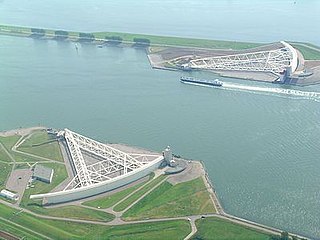
WThe Maeslantkering is a storm surge barrier on the Nieuwe Waterweg, in South Holland, Netherlands. Part of the Delta Works, the barriers are controlled by a supercomputer, and automatically close when Rotterdam is threatened by floods.
 W
WMOSE is a project intended to protect the city of Venice, Italy, and the Venetian Lagoon from flooding.
 W
WThe Navigation Pass S-1 of Saint Petersburg Dam is a storm surge barrier in the eastern part of the Finnish Gulf to the south of the island of Kotlin, Russia. It is part of a waterway from the Baltic Sea to Saint Petersburg located at eastern end of Neva Bay. The scheme of S-1 is similar to the Maeslantkering barrier in the Netherlands and consists of two submersible caissons with dimensions 125×22 metres, which are used to close the navigable channel and thus stop storm tides from proliferating into Neva Bay. The channel is 200 metres wide and 16 metres deep. The Saint Petersburg Ring Road crosses it via an underwater tunnel.
 W
WThe Oosterscheldekering, between the islands Schouwen-Duiveland and Noord-Beveland, is the largest of the thirteen ambitious Delta Works series of dams and storm surge barriers, designed to protect the Netherlands from flooding from the North Sea. The construction of the Delta Works was a response to the widespread damage and loss of life in the North Sea flood of 1953.
WThe Saint Petersburg Flood Prevention Facility Complex, unofficially the Saint Petersburg Dam, is a 25 km (16 mi) long complex of dams for flood control near Saint Petersburg, Russia. The dam extends from Lomonosov northward to Kotlin Island, then turns east toward Cape Lisiy Nos near Sestroretsk.
 W
WThe Inner Harbor Navigation Canal (IHNC) Seabrook Floodgate Structure is a flood barrier in the Industrial Canal in New Orleans, Louisiana. The floodgate is designed to protect the Industrial Canal and the surrounding areas from a storm surge from Lake Ponchartrain. It consists of two 50-foot (15 m) wide vertical lift gates and a 95-foot (29 m) wide sector gate.
 W
WThe Severn Barrage is any of a range of ideas for building a barrage from the English coast to the Welsh coast over the Severn tidal estuary. Ideas for damming or barraging the Severn estuary have existed since the 19th century. The building of such a barrage would constitute an engineering project comparable with some of the world's biggest. The purposes of such a project has typically been one, or several of: transport links, flood protection, harbour creation, or tidal power generation. In recent decades it is the latter that has grown to be the primary focus for barrage ideas, and the others are now seen as useful side-effects. Following the Severn Tidal Power Feasibility Study (2008–10), the British government concluded that there was no strategic case for building a barrage but to continue to investigate emerging technologies. In June 2013 the Energy and Climate Change Select Committee published its findings after an eight-month study of the arguments for and against the Barrage. MPs said the case for the barrage was unproven. They were not convinced the economic case was strong enough and said the developer, Hafren Power, had failed to answer serious environmental and economic concerns.
 W
WThe Tainter gate is a type of radial arm floodgate used in dams and canal locks to control water flow. It is named for Wisconsin structural engineer Jeremiah Burnham Tainter.
 W
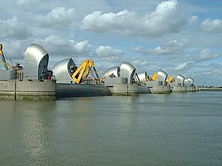
WThe Thames Barrier is a retractable barrier system that is designed to prevent the floodplain of most of Greater London from being flooded by exceptionally high tides and storm surges moving up from the North Sea. It has been operational since 1982. When needed, it is closed (raised) during high tide; at low tide, it can be opened to restore the river's flow towards the sea. Built approximately 3 km (1.9 mi) due east of the Isle of Dogs, its northern bank is in Silvertown in the London Borough of Newham and its southern bank is in the New Charlton area of the Royal Borough of Greenwich.
 W
WThere are three outfall canals in New Orleans, Louisiana – the 17th Street, Orleans Avenue and London Avenue canals. These canals are a critical element of New Orleans’ flood control system, serving as drainage conduits for much of the city. There are 13 miles (21 km) of levees and floodwalls that line the sides of the canals. The 17th Street Canal is the largest and most important drainage canal and is capable of conveying more water than the Orleans Avenue and London Avenue Canals combined.
 W
WThe Vasse and Wonnerup Floodgates is a heritage listed site in Western Australia that comprises two locations. The two locations are the site of the Vasse floodgates on the Vasse River and the Wonnerup floodgates on the Wonnerup Estuary. In addition, the 2004 site of the Vasse floodgates was also the site of the Ballarat Bridge which was built in 1871 as part of a logging rail line where the Ballarat Steam engine was the first steam engine to operate in Western Australia.