 W
WAgo Bay is a bay in the city of Shima, Mie Prefecture, Japan. It is part of the Ise-Shima region.
 W
WThe Aomori Bay is a bay located north of the island of Honshu, in Japan. It is considered to be part of the larger Mutsu Bay.
 W
WAsō Bay is a large, complex inlet that nearly cleaves in two the Japanese island of Tsushima. The bay is notable for its ria coastline, with many peninsulas and various small islands found in close proximity to the shore. It forms part of the Iki-Tsushima Quasi-National Park. Pearls are cultured and Japanese amberjack are farmed in its waters.
 W
WHagushi bay is located in Yomitan, Okinawa. The bay is at the mouth of Hija River. The north side of the mouth of the river has a public beach called Toguchi Beach.
 W
WHiroshima Bay is a bay in the Inland Sea, Japan. Administratively, the bay is divided between Hiroshima and Yamaguchi Prefectures. The bay's shore is a Ria. Its surface area is about 1,000 km², with a mean depth of 25 meters.
 W
WIse Bay is a bay located at the mouth of the Kiso Three Rivers between Mie and Aichi Prefectures in Japan. Ise Bay has an average depth of 19.5 metres and a maximum depth of 30 metres toward the centre. The mouth of the bay is 9 kilometres wide and is connected to the smaller Mikawa Bay by two channels: the Nakayama Channel and the Morosaki Channel. Mikawa Bay is subsequently joined to the Pacific Ocean by the Irako Channel, which ranges from 50 to 100 metres in depth.
 W
WIshikari Bay is a bay located in Hokkaido of Japan, connected to the Sea of Japan. Ishikari Bay is the area east of the straight line from Cape Shakotan on the west of Shakotan Peninsula to Cape Ofuyu.
 W
WKabira Bay is located on the north coast of Ishigaki Island, Okinawa Prefecture, Japan. Renowned for its white sands, turquoise waters and dense vegetation, the bay forms part of the Iriomote-Ishigaki National Park. Alongside Mount Omoto it has been designated a Place of Scenic Beauty. Black pearls are cultured in the bay.
 W
WMatoya Bay is a bay in the city of Shima and Toba, Mie Prefecture, Japan. It is part of the Ise-Shima region.
 W
WMiho Bay is a bay on the north coast of western Honshu, the largest island of Japan. The bay faces the Sea of Japan and within the borders of Tottori Prefecture. Miho bay is bounded to the west by Yumigahama Peninsula, which forms the western border with Shimane Prefecture.
 W
WMikawa Bay is a bay to the south of Aichi Prefecture, Japan, surrounded by Chita Peninsula to the west and Atsumi Peninsula to the east and south. Its area is approximately 604 km2. Pollution of the shallow, enclosed waters of the bay has become a concern in recent years.
 W
WMiyako Bay is a bay in Iwate Prefecture, in the northern Tōhoku region of northern Japan. It is a long and narrow, roughly triangular body of water extending southwest to northeast where it opens to the Pacific Ocean. The Omoe Peninsula forms its southern border and Cape Anegasaki forms its southern border. This gives it an area of approximately 24 km2 (9.3 sq mi).
 W
WMoroiso (諸磯) is the name of an inlet in the Miura Peninsula south of Tokyo in Japan.
 W
WMutsu Bay is a bay located within Aomori Prefecture, in the northern Tōhoku region of northern Japan. It has an east-west distance of approximately 40 kilometers (25 mi) and a north-south distance of approximately 40 kilometers (25 mi) at its eastern end, with a total area of approximately 1,667.89 square kilometers (643.98 sq mi).
 W
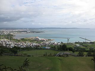
WNakagusuku Bay is a bay on the southern coast of Okinawa Island on the Pacific Ocean in Japan. The bay covers 220 square kilometres (85 sq mi) and ranges between 10 metres (33 ft) to 15 metres (49 ft) deep. The bay is surrounded by the municipalities of Uruma, Kitanakagusuku, Nakagusuku, Nishihara, Yonabaru, Nanjō, all in Okinawa Prefecture. In 1852, while visiting the Ryukyu Kingdom, Commodore Matthew Perry mapped Okinawa and labeled Nakagusuku Bay as "Perry's Bay". During the final months of World War II, the bay became a U.S. Navy forward base, and was nicknamed "Buckner Bay".
 W
WNemuro Bay is a body of water on the northern coast of the Nemuro Peninsula in Hokkaidō, Japan.
 W
WOsaka Bay is a bay in western Japan. As an eastern part of the Seto Inland Sea, it is separated from the Pacific Ocean by the Kii Channel and from the neighbor western part of the Inland Sea by the Akashi Strait. Its western shore is formed by Awaji Island, and its northern and eastern shores are part of the Kansai metropolitan area.
 W
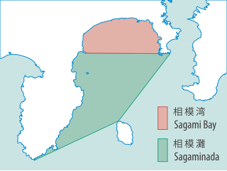
WSagami Bay lies south of Kanagawa Prefecture in Honshu, central Japan, contained within the scope of the Miura Peninsula, in Kanagawa, to the east, the Izu Peninsula, in Shizuoka Prefecture, to the west, and the Shōnan coastline to the north, while the island of Izu Ōshima marks the southern extent of the bay. It lies approximately 40 kilometres (25 mi) southwest of the capital, Tokyo. Cities on the bay include Odawara, Chigasaki, Fujisawa, Hiratsuka, Itō, and Kamakura.
 W
WSōya Bay is a bay on the north coast of Hokkaidō, Japan. It is demarcated by Cape Sōya to the east and Cape Noshappu to the west, with Wakkanai Port to the southwest, and the Sōya Straits to the north. The Koetoi is the main river that flows into the bay. In the middle of the bay mouth, the water is approximately 30 metres (98 ft) deep, while the bed is of rock or sand.
 W
WSuruga Bay is a bay on the Pacific coast of Honshū in Shizuoka Prefecture, Japan. It is situated north of a straight line from Omaezaki Point to Irōzaki Point at the tip of the Izu Peninsula and surrounded by Honshū to the southwest and west and the Izu Peninsula to the east.
 W
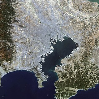
WTokyo Bay is a bay located in the southern Kantō region of Japan, and spans the coasts of Tokyo, Kanagawa Prefecture, and Chiba Prefecture. Tokyo Bay is connected to the Pacific Ocean by the Uraga Channel. Its old name was Edo Bay . The Tokyo Bay region is both the most populous and largest industrialized area in Japan.
 W
WToyama Bay is a bay located on the northern shores of the Hokuriku region of Honshu, Japan on the Sea of Japan The bay borders Toyama and Ishikawa prefectures. The bay is known for the mirages on the horizon during the winter months and for being a spawning ground for the firefly squid. It is also one of Japan's three largest bays. Parts of the bay are within the borders of the Noto Hantō Quasi-National Park.
 W
WThe Uchiura Bay or Funka Bay is a bay southeast of the island of Hokkaido in northern Japan. It has also been known as Iburi Bay and Volcano Bay.
 W
WWakasa Bay is a bay located in the Chūbu region of Japan, and spans the coasts of Kyoto Prefecture, and Fukui Prefecture.