 W
WThe Spring Mountains are a mountain range of Southern Nevada in the United States, running generally northwest-southeast along the west side of Las Vegas and south to the border with California. Most land in the mountains is owned by the United States Forest Service and the Bureau of Land Management and managed as the Spring Mountains National Recreation Area within the Humboldt-Toiyabe National Forest and the Red Rock Canyon National Conservation Area.
 W
WBlue Diamond Hill is a 4,931-foot (1,503 m) peak that borders Red Rock Canyon in Nevada, west of Las Vegas. The Blue Diamond Mine is located on the hill, and the small community of Blue Diamond, Nevada is located nearby. Several housing projects have been proposed for the hill since 2002.
 W
WBridge Mountain is a mountain located in the Spring Mountain range of southern Nevada. It is located on land managed by the United States Bureau of Land Management as the Red Rock Canyon National Conservation Area, part of the Rainbow Mountain Wilderness. Bridge Mountain is named for the natural feature of a bridge-like natural arch of sandstone near the summit.
 W
WThe Carpenter 1 Fire was a large wildfire on Mount Charleston, 25 miles (40 km) northwest of Las Vegas, Nevada. The fire began on July 1, 2013 near Pahrump, Nevada, before spreading eastward. Carpenter 1 was seen for miles across the Las Vegas metropolitan area, and was the largest fire to occur on Mount Charleston in decades. After eight weeks of battling the fire, Carpenter 1 was fully contained on August 18, 2013. The fire consumed nearly 28,000 acres (11,000 ha), causing parts of Nevada State Route 156 and 157 to be closed. This resulted in the evacuation of residents and closure of businesses and portions of the Spring Mountains National Recreation Area. The fire, stretching between 5,000–11,000 feet (1,500–3,400 m) elevations, was fought by hundreds of firefighters and eight Hotshot crews, as well as helicopters, fire engines, water tenders, and a DC-10 tanker plane. According to the National Interagency Fire Center, the Carpenter 1 fire was considered "the highest ranked priority fire in the nation" at the time of its occurrence. Evidence of the damage can still be seen on the South Loop Trail to Charleston Peak.
 W
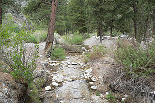
WCarpenter Canyon is a canyon on the western side of the Spring Mountains, partially within the Humboldt-Toiyabe National Forest, in Clark County, southern Nevada west of the Las Vegas Valley.
 W
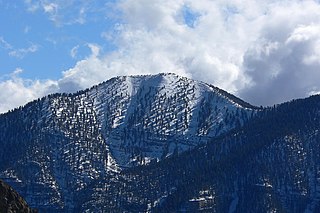
WMount Charleston, including Charleston Peak at 11,916 feet (3,632 m), is the highest mountain in both the Spring Mountains and Clark County, in Nevada, United States. It is the eighth-highest mountain in the state. Well separated from higher peaks by large, low basins, Charleston Peak is the most topographically prominent peak in Nevada, and the eighth-most-prominent peak in the contiguous United States. It is one of eight ultra-prominent peaks in Nevada. It is located about 35 miles (56 km) northwest of Las Vegas within the Mount Charleston Wilderness, which is within the Spring Mountains National Recreation Area of the Humboldt–Toiyabe National Forest.
 W
WThe Mount Charleston Wilderness Area is located west of Las Vegas in the southern part of the state of Nevada in the western United States. It was created by the U.S. Congress in 1989 under the provisions allowed by the Wilderness Act of 1964, and is managed by both the Bureau of Land Management and the U.S. Forest Service.
 W
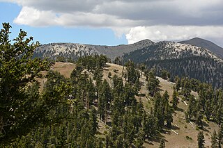
WGriffith Peak is located in the Spring Mountains in Clark County of southern Nevada. It is approximately 28 miles (45 km) northwest of the Las Vegas Strip and 3.9 miles (6.3 km) southeast of Mount Charleston.
 W
WThe Lee Canyon Ski and Snowboard Resort, officially Las Vegas Ski and Snowboard Resort, is located in Lee Canyon, 35 miles (56 km) northwest of Las Vegas, Nevada, United States in the Humboldt-Toiyabe National Forest and Spring Mountains National Recreation Area. The base lodge is situated at the base of Lee Peak, to the north of Mount Charleston, the eighth-highest peak in Nevada. The resort can be reached via US 95 to Nevada State Route 156.
 W
WMcFarland Peak is a limestone peak in the northern portion of the Spring Mountains in Clark County of southern Nevada. It is in the Toiyabe National Forest and the Mount Charleston Wilderness.
 W
WMount Charleston is an unincorporated town and census-designated place in Clark County, Nevada, United States. The population was 357 at the 2010 census.
 W
WMountain Springs is an unincorporated community in Clark County in southern Nevada. It is located in Mountain Springs Summit, the pass over the Spring Mountains through which Highway 160 connects Las Vegas and Pahrump. Public buildings include a fire house and a saloon.
 W
WMummy Mountain is the second highest peak of the Spring Mountains in Clark County, Nevada, United States. It is the twentieth highest mountain in the state. The mountain is located within the Mount Charleston Wilderness and the Humboldt-Toiyabe National Forest.
 W
WState Route 156, also known as Lee Canyon Road, is a state highway in Clark County, Nevada. The road is one of two highways connecting U.S. Route 95 to the Humboldt-Toiyabe National Forest and Spring Mountains area northwest of Las Vegas and its entire length is designated a Nevada Scenic Byway.
 W
WState Route 157, also known as Kyle Canyon Road, is a U.S. state highway in Clark County, Nevada. The highway connects the Las Vegas area to the recreational areas of Mount Charleston in the Spring Mountains.
 W
WState Route 158, also known as Deer Creek Road, is a state highway in Clark County, Nevada. The route connects Kyle Canyon Road to Lee Canyon Road in the Spring Mountains, in the Humboldt-Toiyabe National Forest.
 W
WThe Potosi mining district, or Potosi, was an area in Clark County of southern Nevada, U.S. It is listed on the National Register of Historic Places and includes three structures. The town was named after the famous silver-mining city of Potosi, Bolivia.
 W
WPotosi Mountain is a mountain about 30 miles (50 km) southwest of Las Vegas in the Spring Mountains, in Clark County of southern Nevada.
 W
WThe Red Rock Canyon National Conservation Area in Clark County, Nevada, is an area managed by the Bureau of Land Management as part of its National Landscape Conservation System, and protected as a National Conservation Area. It is about 15 miles (24 km) west of Las Vegas, and is easily seen from the Las Vegas Strip. More than three million people visit the area each year.
 W
WSandstone Ranch or Sand Stone Ranch, as it was first known, was listed on the United States National Register of Historic Places on April 2, 1976. The ranch is within the boundaries of the Spring Mountain Ranch State Park and Red Rock Canyon National Conservation Area and sits below the Wilson Range.
 W
WSpring Mountain Ranch State Park is a public recreation area located within the Red Rock Canyon National Conservation Area in Nevada's Cottonwood Valley, five miles (8.0 km) northwest of Blue Diamond, Nevada. The state park preserves the historic Sandstone Ranch, which was entered into the National Register of Historic Places as a historic district in 1976.
 W
WThe Spring Mountains National Recreation Area (SMNRA) is a U.S. National Recreation Area, administered by the U.S. Forest Service, west of Las Vegas, Nevada. It covers over 316,000 acres. The area runs from low meadows, to the 11,918-foot (3,633 m) Mount Charleston. The SMNRA is a part of the Humboldt-Toiyabe National Forest. It adjoins the Red Rock Canyon National Conservation Area, which is administered by the Bureau of Land Management.
 W
WMount Wilson is a mountain located in the Spring Mountain range of southern Nevada. It is located on land managed by the United States Bureau of Land Management as the Red Rock Canyon National Conservation Area, part of the Rainbow Mountain Wilderness Area. It is the highest peak in the Red Rock Canyon National Conservation Area.