 W
WAltyn-Tagh is a mountain range in Northwestern China that separates the Eastern Tarim Basin from the Tibetan Plateau. The western third is in Xinjiang while the eastern part forms the border between Qinghai to the south and Xinjiang and Gansu to the north.
 W
WBukadaban Feng or Buka Daban Feng, Syn Qing Feng or Bokalik Tagh, is a remote peak on the border between Ruoqiang County, Xinjiang and Qinghai provinces of China. The Chinese term 'Bukadaban Feng' is borrowed from the Uyghur for "bison peak". It is part of the Kunlun Mountains of East-Central Asia. At 6,860 metres (22,507 ft) – the height 7,720 metres (25,328 ft) on older maps was incorrect –, Bukadaban Feng is the highest point of the Qinghai province and with a prominence of 1,922 metres (6,306 ft), it is also an ultra prominent peak. The peak is considered part of Hoh Xil.
 W
WColoane Alto, at 172.4 metres (560 ft) above sea level, is the highest point of Macau, China. It is located on the island of Coloane.
 W
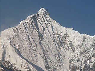
WMount Everest is Earth's highest mountain above sea level, located in the Mahalangur Himal sub-range of the Himalayas. The China–Nepal border runs across its summit point.
 W
WThe Helan Mountains, frequently called Alashan Mountains in older sources, are an isolated desert mountain range forming the border of Inner Mongolia's Alxa League and Ningxia. They run north-south parallel to the north-flowing Yellow River in the Ordos Loop section. The river is mostly east of the mountains, but in the north it crosses without making a significant gorge and flows on the west side. To the west lies the extremely arid Tengger Desert, while to the east is an irrigated area beside the Yellow River, in which lie the cities of Yinchuan and Shizuishan - a little further east of which lies the Mu Us portion of the Ordos Desert. To the north lies the Inner Mongolian city of Wuhai.
 W
WHuangmaojian is a 1,930-meter (6,330 ft) mountain in Longquan County in southwest of Zhejiang province in eastern China. The mountain is the highest peak of Zhejiang and part of the Wuyi Mountains that have their bulk in Fujian province. Huangmaojian is an ultra prominent peak. The mountain is located within the Fengyangshan–Baishanzu National Nature Reserve.
 W
WHuangshan, literally meaning the Yellow Mountain(s), is a mountain range in southern Anhui Province in eastern China. It was originally called “Yishan”, and it was renamed because of a legend that Emperor Xuanyuan once made alchemy here. Vegetation on the range is thickest below 1,100 meters (3,600 ft), with trees growing up to the treeline at 1,800 meters (5,900 ft).
 W
WK2, at 8,611 metres (28,251 ft) above sea level, is the second highest mountain in the world, after Mount Everest at 8,848 metres (29,029 ft). It is located on the China–Pakistan border between Baltistan in the Gilgit-Baltistan region of northern Pakistan, and Dafdar Township in Taxkorgan Tajik Autonomous County of Xinjiang, China. K2 is the highest point of the Karakoram mountain range and the highest point in both Pakistan and Xinjiang.
 W
WKawa Garbo or Khawa Karpo, as it is known by local residents and pilgrims, or Kawagebo Peak, is the highest mountain in the Chinese province of Yunnan. It is located on the border between Dêqên County, Yunnan, and the counties of Zogang and Zayü of the Tibet Autonomous Region. It rises about 20 kilometres (12 mi) west of Shengping (升平镇), the seat of Dêqên County, which lies on China National Highway 214. What is now Dêqên County has been part of Yunnan since the 1720s, when the current border with Tibet was established by the early Qing Dynasty. Kawagarbo is one of the most sacred peaks in the Tibetan world and is often referred to as Nyainqênkawagarbo to show its sacredness and avoid ambiguousness with the other Kawagarbo in the Anung-Derung-speaking Gongshan County.
 W
WKitten Mountain is a 2,142 metres (7,028 ft) mountain located on the border between Ziyuan County and Xing'an County, Guangxi Zhuang Autonomous Region (GZAR) in the People's Republic of China that lies about 80 kilometres (50 mi) from the prefecture-level city of Guilin.
 W
WKongur Tagh or Kongkoerh, is at 7,649 m the highest mountain wholly within the Xinjiang Uyghur Autonomous Region, China.
 W
WMount Gongga, also known as Minya Konka, is the highest mountain in Sichuan province, China. It is also known to locals as "The King of Sichuan Mountains". Situated in the Daxue Shan mountain range, between Dadu River and Yalong River, part of the Hengduan mountainous region, Mount Gongga is the easternmost 7,000 metres (23,000 ft) peak in the world and the third highest peak outside the Himalaya/Karakoram, after Tirich Mir and Kongur Tagh.
WMount Huanggang is the highest peak in the UNESCO designated Wuyi Mountains, China. It separates and is the highest point of both Fujian and Jiangxi provinces.
 W
WMount Tai is a mountain of historical and cultural significance located north of the city of Tai'an, in Shandong province, China. The tallest peak is the Jade Emperor Peak, which is commonly reported as being 1,545 meters (5,069 ft) tall, but is officially described by the PRC government as 1,532.7 meters (5,029 ft) tall.
 W
WMount Wutai, also known by its Chinese name Wutaishan and as Mount Qingliang, is a sacred Buddhist site at the headwaters of the Qingshui in Shanxi Province, China. Its central area is surrounded by a cluster of flat-topped peaks roughly corresponding to the cardinal directions. The north peak is the highest and is also the highest point in northern China.
 W
WPaektu Mountain, also known as Baekdu Mountain and in China as Changbai Mountain, is an active stratovolcano on the Chinese–North Korean border. At 2,744 m (9,003 ft), it is the highest mountain of the Changbai and Baekdudaegan ranges. Koreans assign a mythical quality to the volcano and its caldera lake, considering it to be their country's spiritual home. It is the highest mountain in Korea and Northeast China.
 W
WThe Qilian Mountains, together with the Altyn-Tagh also known as Nan Shan, as it is to the south of Hexi Corridor, is a northern outlier of the Kunlun Mountains, forming the border between Qinghai and the Gansu provinces of northern China.
WShikengkong is a mountain located between Yangshan County and Ruyuan Yao Autonomous County in northern Guangdong, China. With an altitude of 1,902 m (6,240 ft), it is the highest mountain in the province.
 W
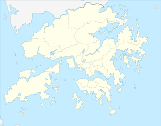
WTai Mo Shan is the highest peak in Hong Kong, with an elevation of 957 metres (3,140 ft). It is also the tallest coastal peak in Southern China and second tallest coastal peak in China after Mount Lao, and located at approximately the geographical centre of the New Territories.
 W
WMount Taibai is a mountain located on the border between Mei, Taibai and Zhouzhi counties in the south west of Shaanxi Province, China. The mount's highest point, Baxian Tower, rises to a height of 3,750 m (12,300 ft) and is the tallest in the Qinling Range, as well as the watershed between the Han River and Wei River. Mount Taibai is also the highest mountain in Eastern China.
 W
WThe Wuyi Mountains or Wuyishan are a mountain range located in the prefecture of Nanping, in northern Fujian province near the border with Jiangxi province, China. The highest peak in the area is Mount Huanggang at 2,158 metres (7,080 ft) on the border of Fujian and Jiangxi, making it the highest point of both provinces; the lowest altitudes are around 200 metres (660 ft). Many oolong and black teas are produced in the Wuyi Mountains, including da hong pao and lapsang souchong.
 W
WWuzhi Mountain is the highest mountain in Hainan, China, towering 1,840 metres (6,040 ft) above the center of Hainan Island. The surrounding areas of Wuzhi Mountain are inhabited mainly by the Li ethnic group. It is located adjacent to Wuzhishan City but is not part of that city's administrative area.
 W
WMount Xiaowutai is a mountain located in Yu County in the northwest of the province of Hebei. With an altitude of 2,882 m (9,455 ft), it is the highest mountain in the province.