 W
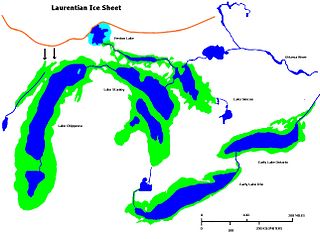
WLake Arkona was a stage of the lake waters in the Huron-Erie-Ontario basin following the end of the Lake Maumee levels and before the Lake Whittlesey stages, named for Arkona, Ontario, about 50 miles (80 km) east of Sarnia.
 W
WThe Calumet Shoreline is an ancient shoreline of Lake Michigan located in the Lake Michigan Basin. It can be clearly seen as a sand ridge along Ridge Road south of Chicago. Closer to the lake from the Calumet Shoreline, there are the Tolleston shorelines and farther from the lake are the Glenwood Shoreline, the Tinley Moraine, and the Valparaiso Moraine. The shoreline is named after the Calumet Region of Northern Indiana.
WLake Chicago was a prehistoric proglacial lake that is the ancestor of what is now known as Lake Michigan, one of North America's five Great Lakes. Fed by retreating glaciers, it drained south through the Chicago Outlet River.
 W
WThe Defiance Moraine was deposited about 14,800 years ago during the late Wisconsin glaciation and spans the northern portion of the state of Ohio from Defiance, Ohio in the west to near Pymatuning Reservoir in the east.
 W
WEarly Lake Erie was a prehistoric proglacial lake that existed at the end of the last ice age approximately 13,000 years ago. The early Erie fed waters to Glacial Lake Iroquois.
 W
WThe Fort Wayne Moraine is considered contemporary to the last stages of the Valparaiso Moraine. Centered on Fort Wayne, Indiana, the northern leg of the moraine is mostly overlaid by the younger Wabash Moraine angling northeastward through Williams County, Ohio. It only becomes identifiable in Lenawee County, Michigan south and northeast of Adrian before ending in the intermingling of moraines around Ann Arbor. The south and eastern leg of the moraine follows the northern bank of the St. Marys River into the State of Ohio. At the north bend of the St. Marys River, the moraine arcs northeastward through Lima, continuing in a northward arc to reach north of U.S. 30 in Hancock County to pass through Upper Sandusky, again bending to the north to end 15 miles (24 km) to 20 miles (32 km) to the northeast.
 W
WThe Glenwood Shoreline is an ancient shoreline of the precursor to Lake Michigan, Lake Chicago. It is named after the town of Glenwood, Illinois. The shoreline was formed when the lake was higher during the last Ice Age, while ice blocked the Straits of Mackinac. After the straits were freed, the lake receded and left behind a sand ridge at an elevation of about 640 feet (200 m) where the shore resided. This ridge can be seen clearly in Glenwood, Illinois, Dyer, Indiana, and Schererville, Indiana, all south of Chicago.
 W
WThe Great Black Swamp was a glacially fed wetland in northwest Ohio, sections of lower Michigan, and extreme northeast Indiana, United States, that existed from the end of the Wisconsin glaciation until the late 19th century. Comprising extensive swamps and marshes, with some higher, drier ground interspersed, it occupied what was formerly the southwestern part of proglacial Lake Maumee, a holocene precursor to Lake Erie. The area was about 25 miles (40 km) wide and 100 miles (160 km) long, covering an estimated 1,500 square miles (4,000 km2). Gradually drained and settled in the second half of the 19th century, it is now highly productive farmland. However, this development has been detrimental to the ecosystem as a result of agricultural runoff. This runoff, in turn, has contributed to frequent toxic algal blooms in Lake Erie.
 W
WAn ice age is a long period of reduction in the temperature of the Earth's surface and atmosphere, resulting in the presence or expansion of continental and polar ice sheets and alpine glaciers. Earth's climate alternates between ice ages and greenhouse periods, during which there are no glaciers on the planet. Earth is currently in the Quaternary glaciation, known in popular terminology as the Ice Age. Individual pulses of cold climate within an ice age are termed glacial periods, and intermittent warm periods within an ice age are called interglacials or interstadials.
 W
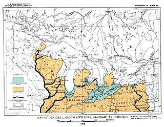
WLake Kankakee formed 14,000 years before present (YBP) in the valley of the Kankakee River. It developed from the outwash of the Michigan Lobe, Saginaw Lobe, and the Huron-Erie Lobe of the Wisconsin glaciation. These three ice sheets formed a basin across Northwestern Indiana. It was a time when the glaciers were receding, but had stopped for a thousand years in these locations. The lake drained about 13,000 YBP, until reaching the level of the Momence Ledge. The outcropping of limestone created an artificial base level, holding water throughout the upper basin, creating the Grand Kankakee Marsh.
WThe Lake Border Moraine is a complex group of moraines bordering the southern end of Lake Michigan. It can be traced north along the eastern shore of the lake basin and across the highlands between the northern Lake Michigan and Saginaw Bay. It continues around the Saginaw Basin into the " thumb " of Michigan, and south through southeastern Michigan on the eastern side of the "thumb." Along Lake Michigan, north to Holland the system is close to the shore. From Holland north to Oceana County it is 15 miles (24 km) to 25 miles (40 km) east of the shore. In Oceana County it forms the prominent "clay banks" along the shoreline of Lake Michigan. It again bears inland from Hart, where more recent moraines reside between it and Lake Michigan. It runs north of the great interlobate moraine that exists between the Lake Michigan and Saginaw lobes of the Laurentian ice sheet. A little north of Cadillac turns to the east. A short distance from Cadillac, it splits with the southern ridge or outer member heading to the Saginaw basin. The northern ridge heads towards Lake Huron, but turns south before reaching the shore. In Newaygo and Lake counties it rest on an earlier interlobate moraine. It separates in Wexford and Missaukee counties to continue south along the west side of the Saginaw basin.
WLake Chippewa was a prehistoric proglacial lake. The basin is now Lake Michigan. It formed about 10,600 years before present (YBP). The lake occupied the depression left by the Michigan Lobe of the Laurentide Ice Sheet.
 W
WThe Laurentide Ice Sheet was a massive sheet of ice that covered millions of square kilometers, including most of Canada and a large portion of the Northern United States, multiple times during the Quaternary glacial epochs, from 2.588 ± 0.005 million years ago to the present.
WThe Marseilles moraine is a terminal moraine that encircles the southern tip of Lake Michigan in North America. It begins near Elgin, Illinois, and extends south and west of Chicago metropolitan area, turning eastward 30 miles (48 km) to 40 miles (64 km) south of the lake in Kankakee and Iroqouis counties, entering Indiana. It formed during the Wisconsin glaciation. The glacier had been in retreat when it stopped for an extended period, depositing glacial till and sand creating the hills of the moraine.
 W
WLake Maumee was a proglacial lake and an ancestor of present-day Lake Erie. It formed about 14,000 Years Before Present (YBP) as the Huron-Erie Lobe of the Laurentide Ice Sheet retreated at the end of the Wisconsin glaciation. As water levels continued to rise the lake evolved into Lake Arkona and then Lake Whittlesey.
 W
WThe Niagara Escarpment is a long escarpment, or cuesta, in the United States and Canada that runs predominantly east–west from New York, through Ontario, Michigan, Wisconsin, and Illinois. The escarpment is most famous as the cliff over which the Niagara River plunges at Niagara Falls, for which it is named.
WThe Packerton Moraine in north-central Indiana has been considered by most persons who have studied it to be a large interlobate moraine between the Saginaw and the Erie lobes. The northeast-southwest direction of the eskers north of Disko, Wabash County, and the southeast-northwest trend south of there indicated that the part of the Packerton moraine south of Disko was built by the Erie lobe and the part north of Disko by the Saginaw lobe. An esker, Miami County shows a northeast-southwest alignment, providing evidence that Packerton moraine in Miami County was built by the Erie lobe. A small area in the northwestern was deposited by the Saginaw lobe. It is named the Packerton moraine from the village of Packerton in Kosciusko County. Thirteen kames and eskers complexes are mixed with sand and gravel. The till is, sandier, especially in the part deposited by the Saginaw lobe, than in the lobe passed over some source of sand, whereas the Erie lobe did not. Water-laid or wind-blown sands are found throughout the moraine. The bulk of the sand seems to have been water-deposited, but locally the sand appears to have been reworked by the wind. Few of the sand deposits exhibit dunal forms.
WLake Stanley, also called the Stanley unconformity, is a postglacial freshwater lake that occupied part of what is now the basin of Lake Huron during a hydrologically significant period from 10,000 years Before Present (B.P.). The lake’s surface level was approximately 70 meters below the current lake’s water surface.
 W
WThe Tinley Moraine is a moraine around the Lake Michigan basin in North America. It was formed during the Wisconsin Glaciation and is younger than the higher and wider terminal moraine called the Valparaiso Moraine, which is located farther from the lake than the Tinley Moraine. Compared to the Valparaiso Moraine, the Tinley Moraine is much narrower and occupies a similar swath, about 6 miles (10 km) closer to Lake Michigan, and passes through the communities of Flossmoor, Western Springs, and Arlington Heights. The moraine probably was named after the village of Tinley Park, a village southwest of Chicago that lies on the moraine.
 W
WThe Valparaiso Moraine is a recessional moraine that forms an immense U around the Lake Michigan basin in North America. It is a band of high, hilly terrain made up of glacial till and sand. It begins near the border of Wisconsin and Illinois and extends south through Lake, McHenry, Cook, DuPage and Will counties in Illinois, and then turns southeast, entering Indiana. From this point, the moraine curves northeast through Lake, Porter, and LaPorte counties of Indiana into Michigan. It continues into Michigan as far as Montcalm County.
 W
WLake Warren was a proglacial lake that formed in the Lake Erie basin around 12,700 years before present (YBP) when Lake Whittlesey dropped in elevation. Lake Warren is divided into three stages: Warren I 690 feet (210 m), Warren II 680 feet (210 m), and Warren III 675 feet (206 m), each defined by the relative elevation above sea level.
 W
WLake Wayne formed in the Lake Erie and Lake St. Clair basins around 12,500 years before present (YBP) when Lake Arkona dropped in elevation. About 20 feet (6.1 m) below the Lake Warren beaches it was early described as a lower Lake Warren level. Based on work in Wayne County, near the village of Wayne evidence was found that Lake Wayne succeeded Lake Whittlesey and preceded Lake Warren. From the Saginaw Basin the lake did not discharge water through Grand River but eastward along the edge of the ice sheet to Syracuse, New York, thence into the Mohawk valley. This shift in outlets warranted a separate from Lake Warren. The Wayne beach lies but a short distance inside the limits of the Warren beach. Its character is not greatly different when taken throughout its length in Michigan, Ohio, Pennsylvania and New York. At the type locality in Wayne County, Michigan, it is a sandy ridge, but farther north, and to the east through Ohio it is gravel. The results of the isostatic rebound area similar to the Lake Warren beaches.
 W
WLake Whittlesey was a proglacial lake that was an ancestor of present-day Lake Erie. It formed about 14,000 years ago. As the Erie Lobe of the Wisconsin Glacier retreated at the end of the last ice age, it left melt-water in a previously-existing depression area that was the valley of an eastward-flowing river known as the Erigan River that probably emptied into the Atlantic Ocean following the route of today's Saint Lawrence River. The lake stood at 735 feet (224 m) to 740 feet (230 m) above sea level. The remanent beach is not horizontal as there is a ‘hinge line’ southwest of a line from Ashtabula, Ohio, through the middle part of Lake St. Clair. The hinge line is where the horizontal beaches of the lake have been warped upwards towards the north by the isostatic rebound as the weight of the ice sheet was removed from the land. The rise is 60 feet (18 m) north into Michigan and the Ubly outlet. The current altitude of the outlet is 800 feet (240 m) above sea level. Where the outlet entered the Second Lake Saginaw at Cass City the elevation is 740 feet (230 m) above sea level. The Lake Whittlesey beach called the Belmore Beach and is a gravel ridge 10 feet (3.0 m) to 15 feet (4.6 m) high and one-eighth mile wide. Lake Whittlesey was maintained at the level of the Ubly outlet only until the ice melted back on the "Thumb" far enough to open a lower outlet. This ice recession went far enough to allow the lake to drop about 20 feet (6.1 m) below the lowest of the Arkona beaches to Lake Warren levels.